Grouard

Last updated

Grouard
Grouard Mission
Canada Alberta relief location map - transverse mercator proj.svg
Red pog.svg
Grouard
Location of Grouard
Canada relief map 2.svg
Red pog.svg
Grouard
Grouard (Canada)
Coordinates: 55°31′13″N116°09′40″W / 55.52028°N 116.16111°W / 55.52028; -116.16111
CountryCanada
Province Alberta
Region Northern Alberta
Census division 17
Municipal district Big Lakes County
Government
  Type Unincorporated
  Governing bodyBig Lakes County Council
Area
 (2021) [1]
  Land4.52 km2 (1.75 sq mi)
Population
 (2021) [1]
  Total166
  Density36.7/km2 (95/sq mi)
Time zone UTC−07:00 (MST)
  Summer (DST) UTC−06:00 (MDT)
Area code(s) 780, 587, 825

Grouard, also known as Grouard Mission, is a hamlet in northern Alberta within Big Lakes County. [2] It was previously an incorporated municipality between 1909 and 1944.

Contents

Grouard is located 13 kilometres (8.1 mi) north of Highway 2, approximately 171 kilometres (106 mi) northeast of Grande Prairie. It is the administrative office of the Kapawe'no First Nations.

Location

Grouard is located near the western shore of one of the three lakes in Big Lakes County, Lesser Slave Lake.

Etymology

The original site was called Stony Point in the Cree language. [3]

The hamlet was called Lesser Slave Lake, until its name was changed to Grouard in 1900 when the town was built. [4] It was named after the Catholic Bishop Émile Grouard, who was a missionary in the north for sixty-nine years. He moved his headquarters to Grouard in 1920, and died there in 1931. [4] It was also referred to as Grouard Mission.

History

Grouard has a rich Indigenous history, which includes the signing of Treaty 8 in 1899. The hamlet, which is in what is now known as Big Lakes County, is located ten kilometres south of the earliest non-Indigenous settlement in the area, where the North West Company established a post in 1802 at Buffalo Bay. [5] In 1871, the Roman Catholic Church followed with a mission, St. Bernard or Grouard Mission, at Stony Point ten kilometres south of the Buffalo Bay post. [4] The Dunvegan mission, built in 1805, served as headquarters for the fur trade along the Peace River. and was also oldest permanent Catholic mission in the area. [4] It was the second oldest permanent Catholic missionary base in the region. [4] The Lesser Slave Lake had considerable populations of Cree and Metis, and Grouard was considered to be a northern Alberta hub for trade and transportation. [6]

The site, which was then known as Stony Point in Cree, was chosen for the historical signing of Treaty 8 between representatives of the Queen Victoria and various First Nations of the Lesser Slave Lake area, the Cree, Beaver, Chipewyan nations, on whose traditional lands, the Crown wanted to "open for settlement, immigration, trade, travel, mining, lumbering" etc. [7] [8]

On September 27, 1909 Grouard was incorporated as a village. [9] and then as a town in December, 1912.

From 1910 until 1916 Grouard was well situated on the transportation route to the Peace River district. In 1913, the community had a population of more than 1,000. In 1916 the Edmonton, Dunvegan and British Columbia Railway (EDBCR) bypassed Grouard by building just 12 miles (19 km) south of the town, choosing instead Lesser Slave Lake's southern shore. The town but was largely abandoned. Many of the residents and businesses moved to High Prairie, a community on the railway line. [10]

Grouard reverted from town status to village status on June 7, 1940, and then dissolved from village status on January 15, 1944 to become part of Improvement District No. 764. [11]

Demographics

In the 2021 Census of Population conducted by Statistics Canada, Grouard had a population of 166 living in 79 of its 117 total private dwellings, a change of

As a designated place in the 2016 Census of Population conducted by Statistics Canada, Grouard Mission had a population of 255 living in 85 of its 110 total private dwellings, a change of

Education

Northland School Division No. 61 hosts grades K-9. Students who continue from grade 9 travel by bus to attend high school in High Prairie. Grouard students also have the option to attend school from K-12 in High Prairie.

Northern Lakes College (NLC)

Grourd and Slave Lake have administrative offices of the Northern Lakes College, a public, comprehensive, community college that is board-governed with over twenty-five campuses in communities across northern Alberta. [13] NLC acknowledges that it is located on Treaty 8 territory and Metis nations regions and traditional First Nations and Metis land. [13]

The Alberta Vocational College (AVC) was renamed the Northern Lakes College on August 25, 1999. [14]

NLC history

In 1970 and 1971, the hamlet of Grouard which is adjacent to Treaty 8 Kapawe'no First Nation land, became the site of Vocational Centreone of a group of sister Community Vocational Centres (CVC's). First Nations students received adult education basic training in Grouard at the Centre to prepare to become instructors in the area covered by the CVC's. [15] [14]

In 1986, major changed were taking place in the Alberta Vocational College (AVC) without consulting those affected, including moving dozens of married students living quarters, programs and materials to High Prairie from Grouard. Grouard residents held demonstrations in protest. The decision was overturned following a meeting which including MLAs and Alberta cabinet ministers. Harold Cardinal, leader of the Indian Association of Alberta for nine terms and former chief of Sucker Creek First Nation asked the Education Minister Dave Russell to not let education at AVC be downgraded and to not ignore the formal political structures First National already had in place to deal with the issue. A working committee composed of First Nations members was created and it was agreed that the college programs would not be moved from Grouard to High Prairie without consultation. [16]

In 1988, the Alberta Vocational Centre in Grouard amalgamated with a network of 26 community vocational centres for First Nations students in northern Alberta to form the Alberta Vocational College. [14] As of September 1, 1997, the AVC has been governed by a public board. Prior to that it was administered by province of Alberta. [14]

Northern Lakes College is one of ancillary spaces that is part of Kapawe'no First Nation School, which is located within the Kapawe'no First Nation. [17] In 2019 the Kapawe’no First Nation School Authority and Kapawe'no First Nation School received authorization under Alberta's Department of Education. [17] The school became fully operational soon after, and offers education from kindergarten through grade twelve. [17]

The Native Cultural Arts Museum is a part of Northern Lakes College and is located in the Moosehorn Lodge at the Grouard campus. [18] The Museum's collection celebrates various aspects of Indigenous cultures, with a special focus on Métis peoples and the Woodland Cree of northern Alberta. [19]

Historically significant site

The Grouard Indian Residential School, also known as St. Bernard’s Residential School, in the then-hamlet of Grouard is included on the online Memorial site maintained by the National Center for Truth and Reconciliation (NCTRC) and UNESCO. [20] The residential school was operated by the Roman Catholic Church from 1894 until 1957. [20]

Approximately 169 potential unmarked graves were discovered on St. Bernard's property in 2022 using ground-penetrating radar and drones. [21] Previously, the names of ten children who had died at St. Bernard's had been listed on the NCTRC and UNESCO Memorial site. [22] The residential school operated from 1894 to 1961. [23]

The St. Bernard mission's church and cemetery, also known as Grouard Mission Church, was recognized by Parks Canada as one of Canada's Historic Places. [24]

Lesser Slave Lake Regional Forests Plan

The Kapawe'no First Nation, whose headquarters are in Grouard, are one of a number of Treaty 8 First Nations and Métis settlements who provide input and expertise in the Lesser Slave Lake Regional Forest Management Plan. [25] Their involvement in forest management respects the constitutional rights of First Nations and Métis Settlements to engage in hunting, fishing, and trapping and for other traditional uses, such as for burial, ceremonial, historical purposes. [25] The First Nations who are included in these consultations include the Bigstone Cree Nation, Driftpile First Nation, Duncan's First Nation, Horse Lake First Nation, Kapawe'no First Nation, Lubicon Lake Band, Sawridge First Nation, Sturgeon Lake Cree Nation, Sucker Creek First Nation, Swan River First Nation, Whitefish Lake First Nation, Woodland Cree First Nation. The Métis Settlements include the East Prairie Métis Settlement, Gift Lake Métis Settlement, and the Peavine Métis Settlement. [25]

Notable people

See also

Related Research Articles

<span class="mw-page-title-main">Cree</span> Group of First Nations peoples in North America

The Cree are a North American Indigenous people. They live primarily in Canada, where they form one of the country's largest First Nations.

<span class="mw-page-title-main">Lesser Slave Lake</span> Body of water in Alberta, Canada

Lesser Slave Lake —known traditionally as "Beaver Lake" or "Beaver people were over there, living there" —is located in central Alberta, Canada, northwest of Edmonton. It is the second largest lake entirely within Alberta boundaries, covering 1,160 km2 (450 sq mi) and measuring over 100 km (62 mi) long and 15 km (9.3 mi) at its widest point. Lesser Slave Lake averages 11.4 m (37 ft) in depth and is 20.5 m (67 ft) at its deepest. It drains eastwards into the Athabasca River by way of the Lesser Slave River.

<span class="mw-page-title-main">Métis</span> Mixed Indigenous ethnic group of Canada and the US

The Métis are an Indigenous people whose historical homelands includes Canada's three Prairie Provinces, as well as parts of British Columbia, the Northwest Territories, Northwest Ontario and the Northern United States. They have a shared history and culture, deriving from specific mixed European and Indigenous ancestry, which became distinct through ethnogenesis by the mid-18th century, during the early years of the North American fur trade.

First Nations in Alberta are a group of people who live in the Canadian province of Alberta. The First Nations are peoples recognized as Indigenous peoples or Plains Indians in Canada excluding the Inuit and the Métis. According to the 2011 Census, a population of 116,670 Albertans self-identified as First Nations. Specifically there were 96,730 First Nations people with registered Indian Status and 19,945 First Nations people without registered Indian Status. Alberta has the third largest First Nations population among the provinces and territories. From this total population, 47.3% of the population lives on an Indian reserve and the other 52.7% live in urban centres. According to the 2011 Census, the First Nations population in Edmonton totalled at 31,780, which is the second highest for any city in Canada. The First Nations population in Calgary, in reference to the 2011 Census, totalled at 17,040. There are 48 First Nations or "bands" in Alberta, belonging to nine different ethnic groups or "tribes" based on their ancestral languages.

<span class="mw-page-title-main">Lac La Biche, Alberta</span> Urban service area in Alberta, Canada

Lac La Biche is a hamlet in Lac La Biche County within northeast Alberta, Canada. It is located approximately 220 km (140 mi) northeast of the provincial capital of Edmonton. Previously incorporated as a town, Lac La Biche amalgamated with Lakeland County to form Lac La Biche County on August 1, 2007.

<span class="mw-page-title-main">Lesser Slave Lake (electoral district)</span> Provincial electoral district in Alberta, Canada

Lesser Slave Lake is a provincial electoral district for the Legislative Assembly of Alberta, Canada. It has existed since 1971 and is mandated to return a single member using the first past the post method of voting.

<span class="mw-page-title-main">Division No. 17, Alberta</span> Census division in Alberta, Canada

Division No. 17 is a census division in Alberta, Canada. It spans the central and northwest portions of northern Alberta and its largest urban community is the Town of Slave Lake. Division No. 17 is the largest census division in Alberta according to area and also has the lowest population density.

<i>Treaty 8</i> Treaty between First Nations and Canadian Crown

Treaty 8, which concluded with the June 21, 1899, signing by representatives of the Crown and various First Nations of the Lesser Slave Lake area, is the most comprehensive of the eleven Numbered Treaties. The agreement encompassed a land mass of approximately 840,000 km2 (320,000 sq mi). Treaty territory, which includes thirty-nine First Nation communities in northern Alberta, northwestern Saskatchewan, northeastern British Columbia, and the southwest portion of the Northwest Territories, making it the largest of the numbered treaty in terms of area. The treaty was negotiated just south of present-day Grouard, Alberta.

The Sakāwithiniwak or Woodland Cree, are a Cree people, calling themselves Nîhithaw in their own dialect of the language. They are the largest indigenous group in northern Alberta and are an Algonquian people. Prior to the 18th century, their territory extended west of Hudson Bay, as far north as Churchill. Although in western Northern Saskatchewan and Manitoba, by the 18th century, they acted as middlemen in trade with western tribes. After acquiring guns through trade, they greatly expanded their territory and drove other tribes further west and north.

<span class="mw-page-title-main">Fort McKay First Nation</span>

The Fort McKay First Nation (FMFN) is a First Nations government in northeast Alberta comprising five Indian reserves – Fort McKay 174, Fort McKay 174C, Fort McKay 174D, Namur Lake 174B and Namur River 174A. The FMFN, signed to Treaty 8, is affiliated with the Athabasca Tribal Council and its members are of Cree, Metis and Dene heritage. The FMFN's traditional lands include portions of the Athabasca oil sands.

Northern Lakes College is a publicly funded comprehensive community college in northern Alberta, Canada.

The following is an alphabetical list of topics related to Indigenous peoples in Canada, comprising the First Nations, Inuit and Métis peoples.

<span class="mw-page-title-main">Fishing Lake Metis Settlement</span> Métis settlement in Alberta, Canada

Fishing Lake Métis Settlement is a Métis settlement in northern Alberta, Canada within the Municipal District of Bonnyville No. 87 and Treaty Six lands. Fishing Lake Métis Settlement was settled by inhabitants of the dissolved St. Paul des Métis settlement and served as a historic Fishing camp to Métis in the region for centuries. It is home to many historical events such as the Frog Lake Resistance and is home to the beginning of the 20th century Métis movement as led by Charles Delorme, Jack Desjarlais and J.F Dion. It is located approximately 15 km (9.3 mi) east of Highway 897 and 52 km (32 mi) south of Cold Lake.

<span class="mw-page-title-main">Kapawe'no 150B</span> Indian reserve in Kapaweno

Kapawe'no 150B, historically known as Freeman 150B, is an Indian reserve of the Kapawe'no First Nation in Alberta, located within Big Lakes County. It is 8 kilometers northwest of Lesser Slave Lake. In the 2016 Canadian Census, it recorded a population of 154 living in of its 45 total private dwellings.

<span class="mw-page-title-main">Beaver Lake Cree Nation</span> Canadian First Nation

The Beaver Lake Cree Nation is a First Nations band government located 105 kilometres (65 mi) northeast of Edmonton, Alberta, representing people of the Cree ethno-linguistic group in the area around Lac La Biche, Alberta, where the band office is currently located. Their treaty area is Treaty 6. The Intergovernmental Affairs office consults with persons on the Government treaty contacts list. There are two parcels of land reserved for the band by the Canadian Crown, Beaver Lake Indian Reserve No. 131 and Blue Quills First Nation Indian Reserve. The latter reserve is shared by six bands; Beaver Lake Cree Nations, Cold Lake First Nations, Frog Lake First Nation, Heart Lake First Nation, Kehewin Cree Nation, Saddle Lake Cree Nation.

<span class="mw-page-title-main">Émile Grouard</span>

Émile Jean-Baptiste Marie Grouard O.M.I., "one of the most influential clerics in northern Alberta," was Apostolic Vicar of Athabasca. A gifted linguist, Grouard learned a number of languages of the indigenous peoples.

<span class="mw-page-title-main">Kapawe'no First Nation</span>

The Kapawe'no First Nation is a band government in Alberta, Canada. It is headquartered at Grouard, Alberta, which is near High Prairie.

<span class="mw-page-title-main">Kapawe'no 150D</span> Indian reserve in Kapaweno

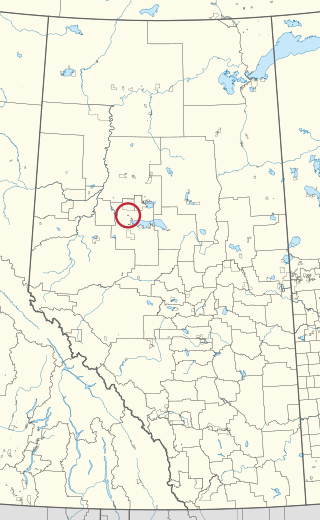
Kapawe'no 150D, formerly known as Pakashan 150D, is an Indian reserve of the Kapawe'no First Nation in Alberta, located within Big Lakes County. It is 13 kilometres northwest of Lesser Slave Lake. In the 2016 Canadian Census, it recorded a population of 5 living in 4 of its 7 total private dwellings.

References

  1. 1 2 3 "Population and dwelling counts: Canada and designated places". Statistics Canada. February 9, 2022. Retrieved February 10, 2022.
  2. "Specialized and Rural Municipalities and Their Communities" (PDF). Alberta Municipal Affairs. January 12, 2022. Retrieved January 21, 2022.
  3. Croucher, Cheryl (April 24, 2018). "The History of Slave Lake". Heritage Trail. Heritage Community Foundation. Retrieved March 3, 2022.{{cite magazine}}: Cite magazine requires |magazine= (help)
  4. 1 2 3 4 5 Phillips, Lee J. (1973). "Lesser Slave Lake". South Peace Historical Society. Retrieved March 3, 2022.
  5. Kudelik, Gail; Leonard, David W. (2008). "Lesser Slave Lake". The Canadian Encyclopedia. Retrieved March 3, 2022.
  6. "HistoricPlaces.ca - HistoricPlaces.ca". Historic Places. Retrieved March 4, 2022.
  7. "Treaty Texts: Treaty No. 8", Government of Canada, November 3, 2008, retrieved March 3, 2022 This contains primary historical documents.
  8. "The Making of Treaty 8 in Canada's Northwest". Alberta Online Encyclopedia. 2009. Archived from the original on May 15, 2009. Retrieved August 1, 2009.
  9. "Annual Report of the Department of Public Works of the Province of Alberta, 1909" (PDF). Government of Alberta. 1910. p. 144. Archived (PDF) from the original on February 15, 2016. Retrieved October 26, 2015.
  10. Brown, Richard. "A Town Bypassed: Grouard, Alberta, and the Building of the Edmonton, Dunvegan and British Columbia Railway". The Archivist. Ottawa: National Archives of Canada (17). ISSN   0705-2855. Archived from the original on August 11, 2011. Retrieved June 12, 2011.
  11. "Table 6a: Population by census divisions and subdivisions showing reorganization of rural areas, 1931-1946". Census of the Prairie Provinces, 1946. Vol. I: Population. Ottawa: Dominion Bureau of Statistics. 1949. p. 428.
  12. "Population and dwelling counts, for Canada, provinces and territories, and designated places, 2016 and 2011 censuses – 100% data (Alberta)". Statistics Canada. February 8, 2017. Archived from the original on February 11, 2017. Retrieved February 13, 2017.
  13. 1 2 New Beginnings - Endless Possibilities. Northern Lakes College (NLC) (Report). Annual Report 2020 - 2021. 2021. Retrieved March 4, 2022.
  14. 1 2 3 4 Northern Lakes College (2003). "College History". Archived from the original on September 21, 2007. Retrieved March 2, 2022. This 2003 article contains detailed historic information on the college{{cite web}}: |archive-date= / |archive-url= timestamp mismatch (help)
  15. history august 1999
  16. Lusty, Terry (June 13, 1986). "Grouard protest defused" (PDF). Windspeaker. Vol. 4, no. 14. AMMSA. Retrieved March 3, 2022.
  17. 1 2 3 "First Nation control of First Nation Education: The Kapawe'no First Nation School Story". South Peace News. September 8, 2021. Retrieved March 2, 2022.
  18. "Northern Lakes College - www.northernlakescollege.ca". Archived from the original on January 15, 2013. Retrieved February 17, 2015.
  19. "Native Cultural Arts Museum and Grouard Historical Village". www.mdbiglakes.ca. Archived from the original on February 17, 2015.
  20. 1 2 Indian Residential School History and Dialogue Centre. St. Bernard's, Alberta (18690) (Report). University of British Columbia. Retrieved March 2, 2022.
  21. Piapot, Ntawnis (March 1, 2022). "Kapawe'no First Nation discovers 169 potential unmarked graves on Alberta residential school site". The Globe and Mail . Retrieved March 2, 2022.
  22. "Grouard (St. Bernard's)". National Center for Truth and Reconciliation and UNESCO. January 28, 2021. Retrieved March 2, 2022.
  23. Germano, Daniela (March 1, 2022). "169 potential graves found at site of former residential school in northern Alberta". CBC News and the Canadian Press. Retrieved March 3, 2022.
  24. St. Bernard Mission (Church and Cemetery) also known as Grouard Mission Church (Report). Canada's Historic Places. Parks Canada. November 23, 1977. Retrieved March 3, 2022.
  25. 1 2 3 "Lesser Slave Lake Regional Forest Management Plan". First Nations and Métis Settlements. Retrieved March 3, 2022.