Grove City, Minnesota

Last updated

Grove City, Minnesota
Grove City, MN-Atlantic Avenue businesses.jpg
Atlantic Avenue businesses
Meeker County Minnesota Incorporated and Unincorporated areas Grove City Highlighted.svg
Location in Meeker County and the state of Minnesota
Coordinates: 45°08′57″N94°40′56″W / 45.14917°N 94.68222°W / 45.14917; -94.68222
CountryUnited States
State Minnesota
County Meeker
Area
[1]
  Total0.66 sq mi (1.71 km2)
  Land0.61 sq mi (1.58 km2)
  Water0.05 sq mi (0.13 km2)
Elevation
[2]
1,211 ft (369 m)
Population
 (2020) [3]
  Total624
  Density1,022.95/sq mi (394.95/km2)
Time zone UTC-6 (CST)
  Summer (DST) UTC-5 (CDT)
ZIP code
56243
Area code 320
FIPS code 27-26126 [4]
GNIS feature ID0644499 [2]
Website www.grovecitymn.com

Grove City is a city in Meeker County, Minnesota, United States. The population was 624 at the 2020 census. [3]

Contents

History

In 1870, the St. Paul and Pacific Railway came to Acton Township and built the Acton Station 2 miles (3 km) east of today's Grove City. There was also a post office one mile north called "Swede Grove". The different locations caused confusion, and the people convinced the railroad to move the station to present-day Grove City. [5]

Grove City was incorporated in 1878. [6] In naming the town, "Grove" was chosen from Swede Grove, and "City" represented the citizens' hope for the town's future. [5] A post office called Grove City has been in operation since 1879, [7] having moved from north of the town. The post office was among the first businesses. Other early businesses included four grocery stories, two hardware stores, four filling stations, two hotels, two lumberyards, two banks, two blacksmiths, a barrel factory, a feed mill, and four grain elevators. There were five saloons, a pool hall, restaurants, a confectioner, a shoe store, a millinery shop, and a bakery. [5]

Geography

Grove City is in western Meeker County. U.S. Highway 12 and Minnesota State Highway 4 are two of the main routes in the community, passing through the north side of the city as Atlantic Avenue. US 12 leads east 9 miles (14 km) to Litchfield, the Meeker county seat, and west 18 miles (29 km) to Willmar, while MN 4 leads north 17 miles (27 km) to Paynesville and south 15 miles (24 km) to Cosmos.

According to the U.S. Census Bureau, Grove City has an area of 0.66 square miles (1.71 km2), of which 0.61 square miles (1.58 km2) are land and 0.05 square miles (0.13 km2), or 0.45%, are water. [1] The city is in the watershed of Grove Creek, which flows northeast to join the Middle Fork of the Crow River near Manannah.

Education

Grove City is the site of (ACGC High School) which combines students from the cities of Atwater, Cosmos, and Grove City in Minnesota.

Demographics

Historical population
CensusPop.Note
1880 230
1890 34951.7%
1900 316−9.5%
1910 35111.1%
1920 38810.5%
1930 372−4.1%
1940 44720.2%
1950 4817.6%
1960 466−3.1%
1970 53113.9%
1980 59612.2%
1990 547−8.2%
2000 60811.2%
2010 6354.4%
2020 624−1.7%
U.S. Decennial Census [8]
2020 Census [3]

2010 census

As of the census [9] of 2010, there were 635 people, 268 households, and 169 families living in the city. The population density was 920.3 inhabitants per square mile (355.3/km2). There were 291 housing units at an average density of 421.7 per square mile (162.8/km2). The racial makeup of the city was 97.0% White, 0.9% African American, 0.2% Native American, 0.3% Asian, 0.2% from other races, and 1.4% from two or more races. Hispanic or Latino of any race were 2.8% of the population.

There were 268 households, of which 31.7% had children under the age of 18 living with them, 44.0% were married couples living together, 11.6% had a female householder with no husband present, 7.5% had a male householder with no wife present, and 36.9% were non-families. 31.3% of all households were made up of individuals, and 11.5% had someone living alone who was 65 years of age or older. The average household size was 2.37 and the average family size was 2.92.

The median age in the city was 35.6 years. 26.8% of residents were under the age of 18; 7% were between the ages of 18 and 24; 26% were from 25 to 44; 24.2% were from 45 to 64; and 16.2% were 65 years of age or older. The gender makeup of the city was 47.6% male and 52.4% female.

2000 census

As of the census of 2000, there were 608 people, 257 households, and 160 families living in the city. The population density was 951.8 inhabitants per square mile (367.5/km2). There were 271 housing units at an average density of 424.2 per square mile (163.8/km2). The racial makeup of the city was 97.86% White, 0.33% Asian, 0.33% from other races, and 1.48% from two or more races. Hispanic or Latino of any race were 2.96% of the population.

There were 257 households, out of which 30.4% had children under the age of 18 living with them, 46.7% were married couples living together, 12.8% had a female householder with no husband present, and 37.4% were non-families. 31.5% of all households were made up of individuals, and 14.4% had someone living alone who was 65 years of age or older. The average household size was 2.37 and the average family size was 2.98.

In the city, the population was spread out, with 28.5% under the age of 18, 10.0% from 18 to 24, 24.0% from 25 to 44, 20.4% from 45 to 64, and 17.1% who were 65 years of age or older. The median age was 36 years. For every 100 females, there were 88.8 males. For every 100 females age 18 and over, there were 86.7 males.

The median income for a household in the city was $29,313, and the median income for a family was $38,750. Males had a median income of $28,125 versus $20,417 for females. The per capita income for the city was $14,237. About 9.4% of families and 12.3% of the population were below the poverty line, including 10.3% of those under age 18 and 22.5% of those age 65 or over.

Related Research Articles

<span class="mw-page-title-main">Ramsey, Minnesota</span> City in Minnesota, United States

Ramsey is a suburban city 22 miles (35 km) north-northwest of downtown Minneapolis in Anoka County, Minnesota, United States. The population was 27,646 at the 2020 census. It is a northwest suburb of the Twin Cities.

<span class="mw-page-title-main">Clarks Grove, Minnesota</span> City in Minnesota, United States

Clarks Grove is a city in Freeborn County, Minnesota, United States. The population was 706 at the 2010 census.

<span class="mw-page-title-main">Spring Grove, Minnesota</span> City in Minnesota, United States

Spring Grove is a city in Houston County, Minnesota, United States. The population was 1,330 at the 2010 census. It is part of the La Crosse-Onalaska, WI-MN Metropolitan Statistical Area.

Hutchinson Township is a township in McLeod County, Minnesota, United States. The population was 1,215 at the 2020 census.

<span class="mw-page-title-main">Stewart, Minnesota</span> City in Minnesota, United States

Stewart is a city in McLeod County, Minnesota, United States. The population was 489 at the 2020 census, down from 571 in 2010.

Acton Township is a township in Meeker County, Minnesota, United States. The population was 381 at the 2000 census. The township includes almost all of Grove City.

<span class="mw-page-title-main">Cosmos, Minnesota</span> City in Minnesota, United States

Cosmos is a city in Meeker County, Minnesota, United States, along the South Fork of the Crow River. The population was 507 at the 2020 census.

Cosmos Township is a township in Meeker County, Minnesota, United States. The population was 229 at the 2000 census.

<span class="mw-page-title-main">Darwin, Minnesota</span> City in Minnesota, United States

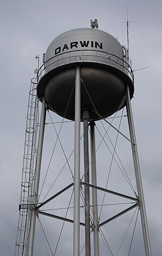
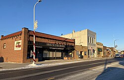
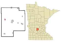
Darwin is a city in Meeker County, Minnesota, United States. The population was 348 at the 2020 census.

Darwin Township is a township in Meeker County, Minnesota, United States. The population was 713 at the 2000 census. The township includes the city of Darwin plus a small eastern portion of the city of Litchfield.

<span class="mw-page-title-main">Dassel, Minnesota</span> City in Minnesota, United States

Dassel is a city in Meeker County, Minnesota, United States. The population was 1,472 at the 2020 census.

<span class="mw-page-title-main">Kingston, Minnesota</span> City in Minnesota, United States

Kingston is a city in Meeker County, Minnesota, United States, located along the North Fork of the Crow River. The population was 184 at the 2020 census.

Swede Grove Township is a township in Meeker County, Minnesota, United States. The population was 414 at the 2000 census.

Union Grove Township is a township in Meeker County, Minnesota, United States. The population was 633 according to the 2010 census. The unincorporated community of Crow River is part of the township.

<span class="mw-page-title-main">Watkins, Minnesota</span> City in Minnesota, United States

Watkins is a city in Meeker County, Minnesota, United States. The population was 991 at the 2020 census.

<span class="mw-page-title-main">Revere, Minnesota</span> City in Minnesota, United States

Revere is a city in Redwood County, Minnesota, United States. The population was 89 at the 2020 census.

<span class="mw-page-title-main">Greenwald, Minnesota</span> City in Minnesota, United States

Greenwald is a city in Stearns County, Minnesota, United States. The population was 222 at the 2010 census. It is part of the St. Cloud Metropolitan Statistical Area.

<span class="mw-page-title-main">Cedar Mills, Minnesota</span> City in Minnesota, United States

Cedar Mills is a city in Meeker County, Minnesota, United States. The population was 62 at the 2020 census.

<span class="mw-page-title-main">Meire Grove, Minnesota</span> City in Minnesota, United States

Meire Grove is a city in Stearns County, Minnesota, United States. The population was 179 at the 2010 census. It is part of the St. Cloud Metropolitan Statistical Area.

<span class="mw-page-title-main">Eden Valley, Minnesota</span> City in Minnesota, United States

Eden Valley is a city in Meeker and Stearns counties in the U.S. state of Minnesota. The population was 1,027 at the 2020 census. Most of Eden Valley is in Meeker County; the Stearns County portion is part of the St. Cloud Metropolitan Statistical Area.

References

  1. 1 2 "2023 U.S. Gazetteer Files: Minnesota". United States Census Bureau. Retrieved January 22, 2024.
  2. 1 2 U.S. Geological Survey Geographic Names Information System: Grove City, Minnesota
  3. 1 2 3 "P1. Race – Grove City city, Minnesota: 2020 DEC Redistricting Data (PL 94-171)". U.S. Census Bureau. Retrieved January 22, 2024.
  4. "U.S. Census website". United States Census Bureau . Retrieved January 31, 2008.
  5. 1 2 3 Halvorson, Darlene (1984). Meeker County Memories. Meeker County Historical Society.
  6. Upham, Warren (1920). Minnesota Geographic Names: Their Origin and Historic Significance. Minnesota Historical Society. p.  340.
  7. "Meeker County". Jim Forte Postal History. Retrieved July 21, 2015.
  8. "Census of Population and Housing". Census.gov. Retrieved June 4, 2015.
  9. "U.S. Census website". United States Census Bureau . Retrieved November 13, 2012.