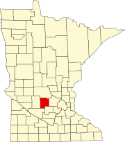
Wright County is a county in the East Central part of the U.S. state of Minnesota. As of the 2020 census, the population was 141,337. Its county seat is Buffalo. The county was founded in 1855. Wright County is part of the Minneapolis-St. Paul-Bloomington, MN-WI Metropolitan Statistical Area. In terms of population, Wright County is the tenth-largest county in Minnesota and the fastest growing.

Meeker County is a county in the U.S. state of Minnesota. As of the 2020 census, the population was 23,400. Its county seat is Litchfield.

McLeod County is a county in the U.S. state of Minnesota. At the 2020 census, the population was 36,771. Its county seat is Glencoe.

Dassel is a city in Meeker County, Minnesota, United States. The population was 1,472 at the 2020 census.

Grove City is a city in Meeker County, Minnesota, United States. The population was 624 at the 2020 census.

Litchfield is a city in and the county seat of Meeker County, Minnesota, United States. The population was 6,624 at the 2020 census.

Cedar Mills is a city in Meeker County, Minnesota, United States. The population was 62 at the 2020 census.
Forest City is an unincorporated community in Forest City Township, Meeker County, Minnesota, United States, near Litchfield and Watkins. The community is located along Meeker County Road 2 near its junction with State Highway 24. The North Fork of the Crow River flows nearby.
Inger is an unincorporated community and census-designated place (CDP) in Itasca County, Minnesota, United States, along the Bowstring River of the Leech Lake Indian Reservation. As of the 2010 census, its population was 212.
Rosendale is an unincorporated community in Danielson Township, Meeker County, Minnesota, United States.
Soudan is an unincorporated community and census-designated place (CDP) in Breitung Township, Saint Louis County, Minnesota, United States. As of the 2010 census, its population was 446.
Merrifield is an unincorporated community and census-designated place (CDP) in Lake Edward Township, Crow Wing County, Minnesota, United States, near Brainerd. It is along Crow Wing County Road 3 near County Road 127. Its population was 140 as of the 2010 census.
Ottawa is an unincorporated community in Ottawa Township, Le Sueur County, Minnesota, United States.

Warsaw is an unincorporated community and census-designated place (CDP) in Warsaw Township, Rice County, Minnesota, United States. As of the 2010 census, its population was 627.
Goodland is an unincorporated community in Goodland Township, Itasca County, Minnesota, United States.
Beaulieu is a census-designated place and unincorporated community in Beaulieu and Chief townships, Mahnomen County, Minnesota, United States. Its population was 103 as of the 2020 census.
Big Lake is an unincorporated community and census-designated place (CDP) in Perch Lake Township, Carlton County, Minnesota, United States. Its population was 443 as of the 2010 census.
Whipholt is an unincorporated community and census-designated place (CDP) in Pine Lake Township, Cass County, Minnesota, United States, along Leech Lake. Its population was 99 as of the 2010 census. The community is located along State Highway 200 near Pine Lake Road. Whipholt is 13 miles east of Walker.
Greenleaf is an unincorporated community in Meeker County, Minnesota, United States, near Litchfield and Cedar Mills. The community is located along Meeker County Road 18 near State Highway 22.
Kimberly is an unincorporated community in Kimberly Township, Aitkin County, Minnesota, United States. The community is located along Aitkin County Road 5 near the junction with County Road 56. Nearby places include Aitkin, Rossburg, Palisade, McGregor, East Lake, and Kimberly Wildlife Management Area. The Rice River flows through the community. State Highways 47 and 210 are both nearby.


