
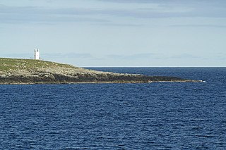
Bressay Lighthouse is still an active lighthouse in the Shetland Islands, Scotland, 4 kilometres (2.5 mi) south-east of Lerwick. It is located on the island of Bressay at Kirkabister Ness overlooking Bressay Sound.

Foula, located in the Shetland archipelago of Scotland, is one of the United Kingdom’s most remote permanently inhabited islands. Owned since the turn of the 20th century by the Holbourn family, the island was the location for the film The Edge of the World (1937). The liner RMS Oceanic was wrecked on the nearby Shaalds of Foula in 1914.

Fetlar is one of the North Isles of Shetland, Scotland, with a usually resident population of 61 at the time of the 2011 census. Its main settlement is Houbie on the south coast, home to the Fetlar Interpretive Centre. Fetlar is the fourth-largest island of Shetland and has an area of just over 4,000 ha.

Bressay is a populated island in the Shetland archipelago of Scotland.

Mousa is a small island in Shetland, Scotland, uninhabited since the nineteenth century. The island is known for the Broch of Mousa, an Iron Age round tower, and is designated as a Special Protection Area for storm-petrel breeding colonies.

Muckle Roe is an island in Shetland, Scotland, in St. Magnus Bay, to the west of Mainland. It has a population of around 130 people, who mainly croft and live in the south east of the island.
Balta is an uninhabited island in Shetland, Scotland.

Bound Skerry is part of the Out Skerries group in the Shetland Islands. As well as being the most easterly island of that group, it is also the easternmost point of Scotland.

Fidra is a currently uninhabited island in the Firth of Forth, 4 kilometres northwest of North Berwick, on the east coast of Scotland. The island is an RSPB Scotland nature reserve.

Linga is a very small uninhabited island in the Bluemull Sound, Shetland, Scotland. It is one of many islands in Shetland called Linga. It has an area of 45 ha and is 26m at its highest point.

Northmavine or Northmaven is a peninsula in northwest Mainland Shetland in Scotland. The peninsula has historically formed the civil parish Northmavine. The modern Northmavine community council area has the same extent. The area of the parish is given as 204.1 km2.

Eshaness Lighthouse is situated on the Northmavine peninsula in the north-west of the Shetland Islands, Scotland. It sometimes rendered as Esha Ness Lighthouse.

Shillay is the westernmost of the Monach Islands (Heisgeir), off North Uist in the Outer Hebrides.

Haaf Gruney is a small island in the north east of the Shetland Islands.

Yell Sound is the strait running between Yell and Mainland, Shetland, Scotland. It is the boundary between the Mainland and the North Isles and it contains many small islands. Sullom Voe, on the shores of which is a substantial oil terminal, is an arm of Yell Sound.

Hoo Stack is a small island off Nesting in Shetland. It is one and a half miles from the North Isle of Gletness. It is 34 metres (112 ft) at its highest point, and is home to a lighthouse, which was built in 1986.
Little Holm is a small island in Yell Sound, in Shetland, Scotland. It lies between Northmavine and the island of Yell.

Lunna Holm is a small island near Lunna Ness, in the Shetland Islands. It is 27 metres (89 ft) at its highest point.

For other islands with similar names, see Linga (disambiguation)

For other islands with similar names, see Gruney (disambiguation)

