List of Northern Lighthouse Board lighthouses

Last updated

This is a list of the currently operational lighthouses of the Northern Lighthouse Board (NLB). The list is divided by geographical location, and then by whether the lighthouses are classed by the NLB as a 'major lighthouse' or a 'minor light'. Former NLB lighthouses now disposed of are not included in the list.

Contents

Scotland (except principal island groups)

Major lighthouses

NameImageAreaBuilt
Ailsa Craig Lighthouse   OOjs UI icon edit-ltr-progressive.svg Ailsa Craig Lighthouse - geograph.org.uk - 1363818.jpg South Ayrshire 1886
Ardnamurchan Lighthouse   OOjs UI icon edit-ltr-progressive.svg Ardnamurchan Lighthouse3.jpg Highland 1849
Bell Rock Lighthouse   OOjs UI icon edit-ltr-progressive.svg Bell Rock Lighthouse 01.jpg Angus 1810
Buchan Ness Lighthouse   OOjs UI icon edit-ltr-progressive.svg Buchan Ness Lighthouse, Boddam - geograph.org.uk - 159596.jpg Boddam 1827 [1]
Cape Wrath Lighthouse   OOjs UI icon edit-ltr-progressive.svg Cape Wrath Lighthouse - geograph.org.uk - 821653.jpg Highland 1828 [2]
Chanonry Lighthouse   OOjs UI icon edit-ltr-progressive.svg Chanonry Point-Lighthouse-A.JPG Chanonry Point 1846 [3]
Corsewall Lighthouse   OOjs UI icon edit-ltr-progressive.svg Corsewell Lighthouse and Hotel - geograph.org.uk - 1708569.jpg Dumfries and Galloway 1817 [4]
Covesea Skerries Lighthouse   OOjs UI icon edit-ltr-progressive.svg Covesea Lighthouse Lossiemouth.JPG Lossiemouth 1846
Crammag Head Lighthouse  OOjs UI icon edit-ltr-progressive.svg New lighthouse at Crammag Head geograph - 1867781 - cropped.jpg Dumfries and Galloway 1913
Davaar Lighthouse   OOjs UI icon edit-ltr-progressive.svg Davaar Lighthouse - geograph.org.uk - 1434658.jpg Argyll and Bute 1854 [5]
Duncansby Head Lighthouse   OOjs UI icon edit-ltr-progressive.svg Duncansby Head, the lighthouse - geograph.org.uk - 596863.jpg Duncansby Head 1924
Dunnet Head Lighthouse   OOjs UI icon edit-ltr-progressive.svg Dunnet Head Lighthouse - geograph.org.uk - 902815.jpg Dunnet Head 1831 [6]
Fidra Lighthouse   OOjs UI icon edit-ltr-progressive.svg FidraLighthouse.JPG East Lothian [7] 1885 [8]
Fife Ness Lighthouse   OOjs UI icon edit-ltr-progressive.svg Fife Ness Lighthouse - geograph.org.uk - 937536.jpg Fife Ness 1975 [9]
Girdleness Lighthouse   OOjs UI icon edit-ltr-progressive.svg Girdle Ness Lighthouse (13795233863).jpg Aberdeen 1833 [10]
Holy Isle Inner Lighthouse  OOjs UI icon edit-ltr-progressive.svg Lighthouse, Holy Island, Arran - geograph.org.uk - 185791.jpg North Ayrshire 1877
Holy Isle Outer Lighthouse  OOjs UI icon edit-ltr-progressive.svg Lighthouse Holy Isle SE.jpg North Ayrshire 1905
Inchkeith Lighthouse   OOjs UI icon edit-ltr-progressive.svg Inchkeith Lighthouse, Firth of Forth - geograph.org.uk - 924165.jpg Fife 1804 [11]
Isle of May Lighthouse   OOjs UI icon edit-ltr-progressive.svg Isle of May Stevenson Lighthouse.jpg Fife [12] 1816 [13]
Kinnaird Head Lighthouses   OOjs UI icon edit-ltr-progressive.svg Lighthouses at Kinnaird Head - geograph.org.uk - 685051.jpg Kinnaird Head
Mull of Galloway Lighthouse   OOjs UI icon edit-ltr-progressive.svg Mull of Galloway - lighthouse.jpg Mull of Galloway 1830
Mull of Kintyre Lighthouse   OOjs UI icon edit-ltr-progressive.svg Mull of Kintyre Lighthouse. - geograph.org.uk - 347240.jpg Mull of Kintyre, Southend 1788 [14]
North Rona Lighthouse  OOjs UI icon edit-ltr-progressive.svg North Rona - geograph.org.uk - 854812.jpg Outer Hebrides 1984
Noss Head Lighthouse   OOjs UI icon edit-ltr-progressive.svg Noss Head Lighthouse (geograph 2595409).jpg Highland 1849 [15]
Pladda Lighthouse   OOjs UI icon edit-ltr-progressive.svg Taighsolaisairpladaigh.jpg North Ayrshire 1790 [16]
Rattray Head lighthouse   OOjs UI icon edit-ltr-progressive.svg Rattray Head Lighthouse - geograph.org.uk - 195991.jpg Rattray Head 1895 [17]
Rua Reidh Lighthouse   OOjs UI icon edit-ltr-progressive.svg Rua-reidh.jpg Highland 1912 [18] [19]
St. Abbs Lighthouse   OOjs UI icon edit-ltr-progressive.svg St Abbs Lighthouse - geograph.org.uk - 597093.jpg Berwickshire 1862 [20]
Sanda Island Lighthouse   OOjs UI icon edit-ltr-progressive.svg Sanda Island Lighthouse - geograph.org.uk - 56803.jpg Argyll and Bute 1850 [21]
Scurdie Ness Lighthouse   OOjs UI icon edit-ltr-progressive.svg Scurdie Ness Lighthouse.jpg Scurdie Ness 1870 [10]
Stoer Head Lighthouse   OOjs UI icon edit-ltr-progressive.svg Stoer Head Lighthouse.jpg Stoer Head, Lochinver 1870 [22]
Strathy Point Lighthouse   OOjs UI icon edit-ltr-progressive.svg The Light House at Strathy Point - geograph.org.uk - 84271.jpg Highland 1958 [23]
Stroma Lighthouse   OOjs UI icon edit-ltr-progressive.svg Stromalighthouse.jpg Caithness 1890
Sule Skerry Lighthouse   OOjs UI icon edit-ltr-progressive.svg The lighthouse on Sule Skerry (geograph 6164846).jpg Orkney Islands 1895 [24]
Tarbat Ness Lighthouse   OOjs UI icon edit-ltr-progressive.svg Tarbat Ness Lighthouse - geograph.org.uk - 501600.jpg Highland [25] 1830 [26]

Minor lights

The Hebrides

Major lighthouses

Minor lights

Orkney

Major lighthouses

Minor lights

Shetland

Major lighthouses

Minor lights

Isle of Man

Major lighthouses

Minor lights

See also

Related Research Articles

<span class="mw-page-title-main">David Stevenson (engineer)</span> Scottish lighthouse designer

David Stevenson MICE FRSE FRSSA was a Scottish lighthouse designer, who designed over 30 lighthouses in and around Scotland, and helped continue the dynasty of lighthouse engineering founded by his father.

<span class="mw-page-title-main">Sutherland</span> Historic county in Scotland

Sutherland is a historic county, registration county and lieutenancy area in the Highlands of Scotland. Its county town is Dornoch. Sutherland borders Caithness and Moray Firth to the east, Ross-shire and Cromartyshire to the south and the Atlantic to the north and west. Like its southern neighbour Ross-shire, Sutherland has some of the most dramatic scenery in Europe, especially on its western fringe where the mountains meet the sea. These include high sea cliffs, and very old mountains composed of Precambrian and Cambrian rocks.

<span class="mw-page-title-main">Ross and Cromarty</span> Area in the Highlands and Islands of Scotland

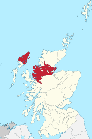
Ross and Cromarty, also referred to as Ross-shire and Cromartyshire, is a variously defined area in the Highlands and Islands of Scotland. There is a registration county and a lieutenancy area in current use, the latter of which is 8,019 square kilometres in extent. Historically there has also been a constituency of the Parliament of the United Kingdom, a local government county, a district of the Highland local government region and a management area of the Highland Council. The local government county is now divided between two local government areas: the Highland area and Na h-Eileanan Siar. Ross and Cromarty border Sutherland to the north and Inverness-shire to the south.

<span class="mw-page-title-main">Argyll</span> Historic county in Scotland

Argyll, sometimes called Argyllshire, is a historic county and registration county of western Scotland.

<span class="mw-page-title-main">Slate Islands</span>

The Slate Islands are an island group in the Inner Hebrides, lying immediately off the west coast of Scotland, north of Jura and southwest of Oban. The main islands are Seil, Easdale, Luing, Shuna, Torsa and Belnahua. Scarba and Kerrera, which lie nearby are not usually included.

<span class="mw-page-title-main">Charles Alexander Stevenson</span> Scottish engineer

Charles Alexander Stevenson MICE MIEE FRSE was a Scottish lighthouse engineer who built twenty-three lighthouses in and around Scotland.

<span class="mw-page-title-main">The Minch</span>

The Minch is a strait in north-west Scotland that separates the mainland from Lewis and Harris in the Outer Hebrides. It was known as Skotlandsfjörð in Old Norse.

<span class="mw-page-title-main">Sula Sgeir</span> Island in Outer Hebrides, Scotland, UK

Sula Sgeir is a small, uninhabited Scottish islet in the North Atlantic, 18 kilometres west of Rona. One of the most remote islands of the British Isles, it lies approximately forty nautical miles north of Lewis and is best known for its population of gannets. It has a narrow elongated shape running north-northeast to south-southwest, and is approximately 900 m long by typically 100 m wide.

<span class="mw-page-title-main">Ross-shire</span> Historic county in Scotland

Stuley is an island lying to the east of South Uist in the Outer Hebrides, Scotland. It lies off the section of coastline between Loch Eynort and Loch Boisdale. It is 45 hectares (0.17 sq mi) and 40 metres (131 ft) at its highest point.

<span class="mw-page-title-main">Yell Sound</span>

Yell Sound is the strait running between Yell and Mainland, Shetland, Scotland. It is the boundary between the Mainland and the North Isles and it contains many small islands. Sullom Voe, on the shores of which is a substantial oil terminal, is an arm of Yell Sound.

<span class="mw-page-title-main">Inverness-shire</span> Historic county in Scotland

Inverness-shire is a historic county, registration county and lieutenancy area of Scotland. Covering much of the Highlands and Outer Hebrides, it is Scotland's largest county, though one of the smallest in population, with 67,733 people or 1.34% of the Scottish population.

<span class="mw-page-title-main">St Magnus Bay</span> Bay in Northwest of Mainland, Shetland

St Magnus Bay is a large coastal feature in the north-west of Mainland Shetland, Scotland. Roughly circular in shape with a diameter of about 19 kilometres (12 mi), it is open to the North Atlantic Ocean to the west. The indented coastline to the north, south and east between Esha Ness in the north and the Ness of Melby in the south contains numerous bays, firths and voes and there are several islands around the perimeter. The waters of the bay are up to 165 metres (541 ft) deep and may have been the site of a substantial meteor impact.

<span class="mw-page-title-main">Alan Brebner</span> Scottish civil engineer

Alan Brebner MInstCE was a Scottish civil engineer, primarily associated with the Stevenson family who designed and built the majority of lighthouses in and around Scotland over several generations.

References

  1. http://www.nlb.org.uk/LighthouseLibrary/Lighthouse/Buchan-Ness/
  2. http://www.nlb.org.uk/LighthouseLibrary/Lighthouse/Cape-Wrath/
  3. http://www.nlb.org.uk/LighthouseLibrary/Lighthouse/Chanonry/
  4. http://www.nlb.org.uk/LighthouseLibrary/Lighthouse/Corsewall/
  5. https://www.nlb.org.uk/LighthouseLibrary/Lighthouse/Davaar/
  6. https://www.nlb.org.uk/LighthouseLibrary/Lighthouse/Dunnet-Head/
  7. http://portal.historicenvironment.scot/designation/LB1336
  8. https://www.nlb.org.uk/LighthouseLibrary/Lighthouse/Fidra/
  9. https://www.nlb.org.uk/LighthouseLibrary/Lighthouse/Fife-Ness/
  10. 1 2 Canmore, Wikidata   Q5032525
  11. https://www.nlb.org.uk/LighthouseLibrary/Lighthouse/Inchkeith/
  12. http://portal.historicenvironment.scot/designation/LB2712
  13. http://www.nlb.org.uk/LighthouseLibrary/Lighthouse/Isle-of-May/
  14. https://www.nlb.org.uk/LighthouseLibrary/Lighthouse/Mull-of-Kintyre/
  15. https://www.nlb.org.uk/LighthouseLibrary/Lighthouse/Noss-Head/
  16. https://www.nlb.org.uk/LighthouseLibrary/Lighthouse/Pladda/
  17. https://www.nlb.org.uk/LighthouseLibrary/Lighthouse/Rattray-Head/
  18. http://www.nlb.org.uk/LighthouseLibrary/Lighthouse/Rubh-Re/
  19. https://canmore.org.uk/site/267701/rubha-reidh-lighthouse
  20. https://canmore.org.uk/site/78115/st-abbs-head-lighthouse
  21. http://www.nlb.org.uk/LighthouseLibrary/Lighthouse/Sanda/
  22. https://www.nlb.org.uk/LighthouseLibrary/Lighthouse/Stoer-Head/
  23. https://www.nlb.org.uk/LighthouseLibrary/Lighthouse/Strathy-Point/
  24. http://www.nlb.org.uk/Lighthouse.aspx?id=849
  25. http://portal.historicenvironment.scot/designation/LB14100
  26. https://www.nlb.org.uk/LighthouseLibrary/Lighthouse/Tarbat-Ness/