Hadlow

Last updated

Hadlow
Hadlow Church.jpg
St. Mary's Church
Kent UK location map.svg
Red pog.svg
Hadlow
Location within Kent
Population3,983 (2011 Census including Golden Green) [1]
OS grid reference TQ635505
District
Shire county
Region
Country England
Sovereign state United Kingdom
Post town Tonbridge
Postcode district TN11
Dialling code 01732
Police Kent
Fire Kent
Ambulance South East Coast
UK Parliament
List of places
UK
England
Kent
51°13′49″N0°20′25″E / 51.23027°N 0.34037°E / 51.23027; 0.34037 Coordinates: 51°13′49″N0°20′25″E / 51.23027°N 0.34037°E / 51.23027; 0.34037

Hadlow is a village in the borough of Tonbridge and Malling in Kent, England. It is situated in the Medway valley, north-east of Tonbridge and south-west of Maidstone.

Contents

The Saxon name for the settlement was Haeselholte (in the Textus Roffensis). The Domesday Book records it as Haslow and in the Middle Ages it became Hadloe and then Hadlow.

History

Evidence of settlement in the Hadlow area dates back to the Stone Age implements, which have been found near the village. [2] The Domesday entry for the village reads:-

Richard de Tonebridge holds of the bishop (of Baieux) Haslow. It was taxed at six sulings. The arable land is twelve carucates. In demesne there are three, and forty-seven villeins, with fifteen borderers, having fifteen carucates. There is a church and ten servants, and two mills of eleven shillings, and twelve fisheries of seven shillings and six-pence, and twelve acres of meadow, Wood for the pannage of sixty hogs. In the time of king Edward the Confessor, and afterwards, and now, it was and is worth thirty pounds. Eddeva held it of king Edward. [3]

During the Middle Ages the manor of Hadlow was owned by the Knights Hospitallers, then the Earls of Gloucester, followed by the Earls of Stafford, who were elevated to the Dukes of Buckingham in 1444. The third Duke of Buckingham was executed in 1521, and the manor went through a series of ownership changes. Sir Henry Guildford being granted the manor by Henry VIII, and the manor passed back to the Crown on his death, it was then granted to the Duke of Northumberland, and again returned to the Crown. in 1558, Henry Carey, the first Baron Hunsdon, received it from Elizabeth I, later passing to his two sons, one of whom Sir George Carey, owned the manor in 1586 The manor house was called Court Lodge at this time. [2]

Hadlow Tower May's Folly, Hadlow Castle, Kent.jpg
Hadlow Tower

Early in the 17th century, it was sold to James Faircloth, a London Physician. He sold it to George Rivers, second son of Sir George Rivers of Chafford. A new manor house, Hadlow Court Lodge was built c.1635. The Rivers family also owned Fish Hall, Tonbridge, which was in the possession of the Fane family during the time of Henry VIII but was later bought by the Rivers. In 1657 the manor was the property of Sir Thomas Rivers. but it was sold, along with Fish Hall, during the reign of Charles II to Jeffrey Amherst. He sold the manor and Fish Hall to John France in 1700. John France had two daughters, Sarah (baptised 1700) and Elizabeth (baptised 1703). They shared the estate upon the death of their father, Elizabeth taking Fish Hall, and Sarah taking Hadlow manor. Sarah married Walter Barton. Their first son, John, was born deaf, blind and dumb. Their second son, Walter, inherited a large fortune from his uncle Richard May in 1763, on condition that he took the surname May. Walter May married Elizabeth Stanford of Strettit Place, East Peckham in 1775. He inherited Hadlow Court Lodge in 1786 and immediately set to work demolishing Hadlow Court Lodge and building Hadlow Castle. [2]

Bourne Mill Bourne Mill Hadlow.JPG
Bourne Mill

His son Walter Barton May added a 153 feet (47 m) high folly in 1835. The folly was damaged in the Great Storm of 1987. Being Grade 1 Listed and previously being included in the 1998 World Monuments Watch List of 100 Most Endangered Sites by the World Monuments Fund, the owner of the folly was issued with a Compulsory Purchase Order by Tonbridge and Malling Borough Council in July 2006. [4] [2]

The main village street is brick-paved and there are several old houses and two Tudor inns. Hadlow Pharmacy on The Square has a history which can be traced back to at least 1856. The River Bourne flows through the parish, and formerly powered a watermill in the village (Bourne mill), which has been the home of Carr & Westley since they moved from London during the blitz and two in Golden Green (Goldhill Mill and Pierce Mill). A set of Hopper huts from North Frith Farm has been dismantled and re-erected at the Museum of Kent Life, Sandling.

The village's amateur dramatic society, Hadlow Amateur Dramatic Society (HADS), have been performing pantomimes and dramatic pieces to Hadlow for over 30 years. [5]

Churches

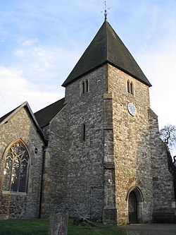
The church is dedicated to St. Mary, and was first mentioned in 975, thus it celebrated 1000 years in 1975. Hadlow was given to Eddeva in 1018, and parts of the church date to this time. The tower dates to the thirteenth century or earlier. The main door of the church has the date 1637 on it. This is often misread as 1037 due to most of the upper part of the first 6 being missing. The clock, by John Thwaites of Clerkenwell, dates from 1791. [6] In the churchyard is a 19th-century memorial to the drowning locally of 30 hop-pickers.

Other churches and chapels in Hadlow include a Baptist Chapel in Court Lane, which was built in 1830. [7] The Catholic chapel on Maidstone Road is dedicated to St. Peter. [8] [9] In Golden Green there was a Wesleyan chapel which opened in 1899 and closed in 1956. [7] A tin tabernacle had been built in Golden Green by 1882, [10] as of 2010, it remains standing. [11]

Breweries

Hadlow had working breweries between the early eighteenth century and the late 1940s. The earliest reference to a brewery in Hadlow is in 1710 when John Barton, Yeoman of Hadlow is mentioned in connection with a newly erected malthouse in Hadlow Street. In 1840 there was a complaint that the drain leading from the Close Brewery was a nuisance. [12]

In 1851 the brewery was being run by Messrs Harrison & Taylor and in 1858 they sold the business to Edward Kenward of Marden and William Barnett of Willingdon, Sussex . Thomas Simmonds of East Peckham and Nelson Kenward were also parties, part purchasing and part leasing the brewery. in 1859 it was agreed that a new 15 quarter malthouse would be erected. This building being the one nearly parallel to the High Street. In 1868 Edward Kenward was bankrupt, owing £9,500. The partnership was dissolved in that year by mutual consent. Edward and Trayton Kenward then became partners, but this partnership was also dissolved and all properties assigned to Trayton Kenward. [12]

The converted maltings Close Brewery.jpg
The converted maltings

In October 1871, Trayton and Charles Kenward entered into partnership with John Court. The business operating under the name of Kenward & Court. Sometime after this a second maltings was added, this running alongside Carpenters Lane. In 1881 the brewery supplied 68 public houses and was listed as 637th in the list of the first thousand limited companies. Kenward & Court was taken over by Charles Hammerton & Co. Ltd. in 1945. Beer was last brewed in September 1949. In 1952 Hammerton's was bought out by Watney's, who then sold the brewery to Charrington's. Malting continued for several years and the brewery closed in the late 1960s, having been used as a distribution centre towards the end. The buildings gradually became derelict through the 1970s, and the Hadlow Society pressed for the buildings to be listed, which was done in July 1979. There was much debate within the village as to whether the buildings should be demolished or converted. The buildings were converted into flats in 1990. [12]

In 2005, Harvey's of Lewes brewed Hadlow Ale to commemorate Kenward & Court and celebrate the reopening of the Two Brewers pub (formerly the Fiddling Monkey and before that the Albion). [13] The buildings are Grade II listed. [14]

Another brewery stood at Style Place, Hadlow. This brewery was started in the 1830s by William Simmons, being in partnership with Henry Simmons in 1852 with William Martin joining them by 1855. The business was sold to Messrs Style & Winch of Chatham in 1863. The brewery buildings have been converted to housing and are now known as Caxton Place. [15] The surviving building is Grade II listed. [16]

Education

Hadlow College of Agriculture and Horticulture was established in 1968. It is concerned with a wide range of land-based training including agriculture, horticulture, medicinal horticulture, landscape management, garden design, equine management, animal management and sciences, sports fisheries and countryside management.

Hadlow Rural Community School is a secondary school that was established in the village in 2013 as part of the free schools programme.

Hadlow Primary School [ permanent dead link ] is located on School Lane and has 7 classes, one form entry, and approx 200 pupils. The school has a large playing field and is currently fundraising for a new community swimming pool.

Hadlow Cricket Club

The cricket ground Hadlow CC.JPG
The cricket ground

Hadlow Cricket Club dates back to the mid-eighteenth century. Cricket is still played in Hadlow, the ground being located off Common Road, to the north of the village.

Notable people

Related Research Articles

<span class="mw-page-title-main">Aylesford</span> Human settlement in England

Aylesford is a village and civil parish on the River Medway in Kent, England, 4 miles (6 km) northwest of Maidstone.

<span class="mw-page-title-main">River Medway</span> River in South East England

The River Medway is a river in South East England. It rises in the High Weald, East Sussex and flows through Tonbridge, Maidstone and the Medway conurbation in Kent, before emptying into the Thames Estuary near Sheerness, a total distance of 70 miles (113 km). About 13 miles (21 km) of the river lies in East Sussex, with the remainder being in Kent.

<span class="mw-page-title-main">Snodland</span> Human settlement in England

Snodland is a town in the borough of Tonbridge and Malling in Kent, England. It lies on the River Medway, between Rochester and Maidstone, and approximately 27 miles (43 km) from central London. At the 2011 Census, it had a population of 10,211.

<span class="mw-page-title-main">Tonbridge</span> Market town in Kent, England

Tonbridge is a market town in Kent, England, on the River Medway, 4 miles (6 km) north of Royal Tunbridge Wells, 12 miles (19 km) south west of Maidstone and 29 miles (47 km) south east of London. In the administrative borough of Tonbridge and Malling, it had an estimated population of 41,293 in 2018.

<span class="mw-page-title-main">Tonbridge and Malling</span> Non-metropolitan district in England

Tonbridge and Malling is a local government district with borough status in Kent, England. Tonbridge is the largest settlement but the authority is based in the modern development of Kings Hill.

<span class="mw-page-title-main">Hadlow Castle</span> Folly in Kent, England

Hadlow Castle was an 18th-century country house in Hadlow, Kent, England, built in the fashionable Strawberry Hill 'Gothic' style. The house was gradually enlarged and extended during the 19th century and finally demolished in the 20th, apart from a prospect tower and ancillary buildings. The surviving Grade I Listed Hadlow Tower, locally known as May's Folly, was restored in 2013.

<span class="mw-page-title-main">West Malling</span> Human settlement in England

West Malling is a market town in the Tonbridge and Malling district of Kent, England. It has a population of 2,590.

<span class="mw-page-title-main">Sutton Valence</span> Human settlement in England

Sutton Valence is a village about five miles (8 km) SE of Maidstone, Kent, England on the A274 road going south to Headcorn and Tenterden. It is on the Greensand Ridge overlooking the Vale of Kent and Weald. St Mary's Church is on the west side of the village on Chart Road, close to the junction of the High Street with the A274. Another landmark is Sutton Valence Castle on the east side of the village, of which only the ruins of the 12th century keep remain, under the ownership of English Heritage.

<span class="mw-page-title-main">East Peckham</span> Village and parish in Kent, England

East Peckham is a village and civil parish in Kent, England on the River Medway. The parish covers the main village as well as Hale Street and Beltring.

<span class="mw-page-title-main">Ditton, Kent</span> Human settlement in England

Ditton is a large village and civil parish in the borough of Tonbridge and Malling in Kent, England. The village is 4.6 miles (7.4 km) west-northwest of Maidstone and 1.8 miles (2.9 km) east of West Malling. The parish, which is long and narrow, straddles the A20, with farmland to the south and industry to the north. It lies in the Medway Valley, on the northern edge of the Kent Weald, and adjoins the ancient parishes of Larkfield, Aylesford and Barming.

<span class="mw-page-title-main">Mereworth Castle</span> Country house in Mereworth, Kent

Mereworth Castle is a grade I listed Neo-Palladian country house in Mereworth, Kent, England.

<span class="mw-page-title-main">Wateringbury</span> Human settlement in England

Wateringbury is a village and civil parish near the town of Maidstone in Kent, England. The Wateringbury Stream flows into the River Medway just above Bow Bridge. It formerly powered three watermills in the village, one of which survives. The Wateringbury railway station is on the Medway Valley Line.

Ryarsh is a village and civil parish in the local government district of Tonbridge and Malling in Kent, England. It is home to around 1,000 residents. Ryarsh is west of Maidstone and north of West Malling.

The high sheriff is the oldest secular office under the Crown. Formerly the high sheriff was the principal law enforcement officer in the county but over the centuries most of the responsibilities associated with the post have been transferred elsewhere or are now defunct, so that its functions are now largely ceremonial. The high sheriff changes every March.

<span class="mw-page-title-main">River Bourne, Kent</span> River in Kent, England

The River Bourne rises in the parish of Ightham, Kent and flows in a generally south easterly direction through the parishes of Borough Green, Platt, Plaxtol, West Peckham, Hadlow, and East Peckham where it joins the River Medway. In the 18th century the river was known as the Busty or Buster, the Shode or Sheet, but is not known by these names nowadays. A bourne is a type of stream, while shode means a branch of a river.

<span class="mw-page-title-main">Staplehurst</span> Human settlement in England

Staplehurst is a town and civil parish in the borough of Maidstone in Kent, England, 9 miles (14 km) south of the town of Maidstone and with a population of 6,003. The town lies on the route of a Roman road, which is now incorporated into the course of the A229. The name Staplehurst comes from the Old English 'stapol' meaning a 'post, pillar' and 'hyrst', as a 'wooded hill'; therefore, 'wooded-hill at a post', a possible reference to a boundary marker at the position of All Saints' church atop the hill along the road from Maidstone to Cranbrook. The parish includes the hamlet of Hawkenbury.

Irene Joan Thirsk, was a British economic and social historian, specialising in the history of agriculture. She was the leading British early modern agrarian historian of her era, as well as an important social and economic historian. Her work highlighted the regional differences in agricultural practices in England. She also had an interest in food history and local English history, in particular of Hadlow, Kent.

<span class="mw-page-title-main">St. Mary's Church, Hadlow</span> Church in Kent, England

St Mary's Church is the parish church in Hadlow, Kent, United Kingdom. The church is a Grade II* listed building.

References

  1. "Civil Parish population 2011". Neighbourhood Statistics. Office for National Statistics. Retrieved 23 September 2016.
  2. 1 2 3 4 5 Thirsk, Joan (1985). Hadlow Castle, a Short History. Hadlow: Hadlow Historical Society. ISBN   0-9510425-0-5.
  3. "HADLOW". British History Online. Retrieved 22 October 2008.
  4. BBC
  5. "Welcome to HADS".
  6. St. Mary's, Hadlow Archived 29 October 2008 at the Wayback Machine
  7. 1 2 "Hadlow". North West Kent Family History Society. Retrieved 14 October 2010.
  8. "St. Peter's Chapel (served from Tonbridge)". Cathcommunity. Archived from the original on 25 July 2011. Retrieved 14 October 2010.
  9. "St. Peter's Catholic Chapel, Maidstone Road, Hadlow". Geograph. Retrieved 14 October 2010.
  10. "Kelly's Directory, 1882". Archived from the original on 23 July 2011. Retrieved 17 October 2010.
  11. "Golden Green Church". Susan Howard. Retrieved 17 October 2010.
  12. 1 2 3 Hughes, Anne (1991). The Close Brewery Hadlow. Hadlow: Hadlow Historical Society. ISBN   0-9510425-1-3.
  13. BBC
  14. Historic England. "THE MALTINGS I AND II, HIGH STREET (north side), HADLOW, TONBRIDGE AND MALLING, KENT (1070448)". National Heritage List for England . Retrieved 9 June 2008.
  15. Labology Archived 12 November 2007 at the Wayback Machine
  16. Historic England. "STYLE PLACE BREWERY, COURT LANE, HADLOW, TONBRIDGE AND MALLING, KENT (1237143)". National Heritage List for England . Retrieved 9 June 2008.
  17. "Allison takes title". Kent and Sussex Courier. 30 March 1990.

Sources