
Sevenoaks is a town in Kent with a population of 29,506 situated south-east of London, England. Also classified as a civil parish, Sevenoaks is served by a commuter main line railway into London. Sevenoaks is 21 miles (34 km) from Charing Cross, the traditional centre of London. It is the principal town of the Sevenoaks district, followed by Swanley and Edenbridge.

Tonbridge is a market town in Kent, England, on the River Medway, 4 miles (6 km) north of Royal Tunbridge Wells, 12 miles (19 km) south west of Maidstone and 29 miles (47 km) south east of London. In the administrative borough of Tonbridge and Malling, it had an estimated population of 41,293 in 2019.

Scope is a disability charity in England and Wales that campaigns to change negative attitudes about disability, provides direct services, and educates the public. The organisation was founded in 1952 by a group of parents and social workers who wanted to ensure that their disabled children had the right to a decent education. Originally focused on cerebral palsy, Scope now embraces all conditions and impairment. Scope subscribes to the social model of disability rather than the medical model of disability – that a person is disabled by the barriers placed in front of them by society, not because of their condition or impairment.

Tonbridge School is a public school in Tonbridge, Kent, England, founded in 1553 by Sir Andrew Judde. It is a member of the Eton Group and has close links with the Worshipful Company of Skinners, one of the oldest London livery companies.

The Judd School is an 11–18 voluntary aided, grammar school and sixth form in Tonbridge, Kent, England. It was established in 1888 at Stafford House on East Street in Tonbridge, where it remained for eight years before moving to its present location on Brook Street, in the south of the town. Founded by the Worshipful Company of Skinners, it was named after 16th century merchant Sir Andrew Judde, whose endowment helped fund the school. The Skinners' Company maintains close links with the school and makes up the majority of the governing body.
Sevenoaks School is a highly selective coeducational English public school with provision for day attendees in Sevenoaks, Kent, England. It is the second oldest non-denominational school in the United Kingdom, dating back to 1432, only behind Oswestry (1407). Around 1,200 day pupils and boarders attend, ranging in age from 11 to 18 years. There are approximately equal numbers of boys and girls. In 2006 it became the first major UK school to switch entirely from A level exams to the International Baccalaureate.

The River Eden is a tributary of the River Medway in south east England. It rises at the foot of the North Downs escarpment near Titsey in Surrey and runs initially southwards through Oxted before turning eastwards to enter Kent. After flowing through Edenbridge and passing Hever Castle, the Eden meets the Medway at Penshurst.

The Darent is a Kentish tributary of the River Thames and takes the waters of the River Cray as a tributary in the tidal portion of the Darent near Crayford. 'Darenth' is frequently found as the spelling of the river's name in older books and maps, Bartholomew's Canals and River of England being one example. Bartholomew's Gazetteer (1954) demonstrates that Darent means "clear water", a result of it springing from and running through chalk. The purity of the water was a major factor in the development of paper and pharmaceuticals in the area.

Borough Green is situated in the borough of Tonbridge and Malling in Kent, England. The central area is situated on the A25 road between Maidstone and Sevenoaks, with the M26 motorway running through the centre dividing Wrotham and Borough Green.

Tonbridge railway station is on the South Eastern Main Line in England, serving the town of Tonbridge, Kent. It is 29 miles 46 chains (47.6 km) from London Charing Cross via Sevenoaks. Trains calling at the station are operated by Southeastern and Southern.
The Eton Group is an association of 12 English public schools within the Headmasters' and Headmistresses' Conference. The Eton Group schools often cooperate with each other, organising events and school matches. For example, the Heads of academic departments meet to discuss curriculum matters of common interest. The Headteachers and the Bursars also meet from time to time. Unlike the older Rugby Group, which contains only boarding schools, the Eton Group includes both boarding schools outside of London and London schools taking day pupils.
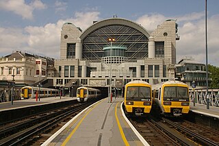
The South Eastern Main Line is a major long-distance railway route in South East England, UK, one of the three main routes crossing the county of Kent, going via Sevenoaks, Tonbridge, Ashford and Folkestone to Dover. The other routes are the Chatham Main Line which runs along the north Kent coast to Ramsgate or Dover via Chatham and High Speed 1 which runs through the centre of Kent to the coast at Folkestone where it joins the Channel Tunnel.
The New Beacon Preparatory School is an independent all-boys preparatory school, located at Sevenoaks in the English county of Kent. It admits both day students and boarders aged between 4 and 13. The school also now offers a co-educational nursery for children 3 years of age and over. The school was founded in 1863, and has been on the current site since 1900. It had 62 students in 1913, and had grown to 400 students by 2008.
Ryarsh is a village and civil parish in the local government district of Tonbridge and Malling in Kent, England. It is home to around 1,000 residents. Ryarsh is west of Maidstone and north of West Malling.

The River Bourne rises in the parish of Ightham, Kent and flows in a generally south easterly direction through the parishes of Borough Green, Platt, Plaxtol, West Peckham, Hadlow, and East Peckham where it joins the River Medway. In the 18th century the river was known as the Busty or Buster, the Shode or Sheet, but is not known by these names nowadays. A bourne is a type of stream, while shode means a branch of a river.
The Medway and its tributaries and sub-tributaries have been used for over 1,150 years as a source of power. There are over two hundred sites where the use of water power is known. These uses included corn milling, fulling, paper making, iron smelting, pumping water, making gunpowder, vegetable oil extraction, and electricity generation. Today, there is just one watermill working for trade. Those that remain have mostly been converted. Such conversions include a garage, dwellings, restaurants, museums and a wedding venue. Some watermills are mere derelict shells, lower walls or lesser remains. Of the majority, there is nothing to be seen.
The Medway and its tributaries and sub-tributaries have been used for over 1,150 years as a source of power. There are over two hundred sites where the use of water power is known. These uses included corn milling, fulling, paper making, iron smelting, pumping water, making gunpowder, vegetable oil extraction, and electricity generation. Today, there is just one watermill working for trade. Those that remain have mostly been converted. Such conversions include a garage, dwellings, restaurants, museums and a wedding venue. Some watermills are mere derelict shells, lower walls or lesser remains. Of the majority, there is nothing to be seen. A large number of tributaries feed into the River Medway. The tributaries that powered watermills will be described in the order that they feed in. The mills are described in order from source to mouth. Left bank and right bank are referred to as though the reader is facing downstream. This article covers the watermills on the tributaries that feed in below Penshurst and above Yalding.
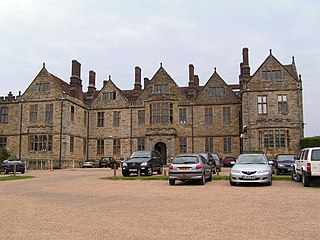
Somerhill House is a Grade I listed Jacobean mansion situated near Tonbridge, Kent, United Kingdom. It was built for The 4th Earl of Clanricarde in 1611–13. The estate was sequestrated by Parliament in 1645, and restored to its rightful owner in 1660. The building had become derelict by the mid-eighteenth century but was later restored. Somerhill was painted by Turner in 1811. It was bought by a member of the Goldsmid family in 1849 and greatly extended between 1879 and 1897, making it the second largest house in Kent, after Knole House, Sevenoaks.
Leigh Academy Tonbridge, formerly Hayesbrook School, is a non-selective secondary school with academy status in Tonbridge, Kent, United Kingdom. It has specialisms in Sports and Mathematics.
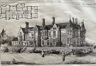
Dene Park is a Victorian mansion house and estate in the parish of Hadlow, Kent, United Kingdom. It served as the site of the Thomas Delarue School between 1955 and 1965.
