
Klamath Falls is a city in, and the county seat of, Klamath County, Oregon, United States. The city was originally called Linkville when George Nurse founded the town in 1867. It was named after the Link River, on whose falls the city was sited. The name was changed to Klamath Falls in 1893. The population was 21,813 at the 2020 census. The city is on the southeastern shore of the Upper Klamath Lake. It is located 80 miles (130 km) east of Medford, 250 miles (400 km) northwest of Reno, and approximately 10 miles (16 km) north of the California–Oregon border.
Eastern Oregon is a region of the U.S. state of Oregon. It is not an officially recognized geographic entity; thus, the boundaries of the region vary according to context. It is sometimes understood to include only the eight easternmost counties in the state; in other contexts, it includes the entire area east of the Cascade Range. Cities in the basic eight-county definition include Baker City, Burns, Hermiston, Pendleton, Boardman, John Day, La Grande, and Ontario. Umatilla County is home to the largest population base in Eastern Oregon, accounting for 42% of the region's residents — more than twice that of the region’s second most populous, Malheur County. Hermiston, located in Umatilla County, is the largest city in the region, accounting for 10% of the population. Major industries include transportation/warehousing, timber, agriculture and tourism. The main transportation corridors are I-84, U.S. Route 395, U.S. Route 97, U.S. Route 26, U.S. Route 30, and U.S. Route 20.

Bly is an unincorporated community in Klamath County, Oregon, United States. By highway, it is about 50 miles (80 km) east of Klamath Falls. As of 2020, the population was 207.

The Coast Starlight is a long-distance passenger train operated by Amtrak on the West Coast of the United States between Seattle and Los Angeles via Portland and the San Francisco Bay Area. The train, which has operated continuously since Amtrak's formation in 1971, was the first to offer direct service between Seattle and Los Angeles. Its name is a combination of two prior Southern Pacific (SP) trains, the Coast Daylight and the Starlight.
Beatty is an unincorporated community and census-designated place (CDP) in Klamath County, Oregon, United States. Beatty is along Oregon Route 140 at the confluence of the Sycan and Sprague rivers and is 40 miles (64 km) by highway northeast of Klamath Falls.
Sprague River is an unincorporated community in Klamath County, Oregon, United States. It is about 45 miles (72 km) northeast of Klamath Falls near the Sprague River, northwest of Oregon Route 140.

Oregon Route 140 is a state highway in southern Oregon, United States. It is the longest state highway in Oregon, running 237 miles (381 km) from the community of White City, Oregon, through Klamath Falls and on to Lakeview. It then continues east, eventually descending into the state of Nevada.
Dairy is an unincorporated community in Klamath County, Oregon, United States.

The OC&E Woods Line State Trail is a rail trail in Klamath and Lake counties in the U.S. state of Oregon. It is Oregon's longest state park. The trail follows the old OC&E and Weyerhaeuser railroads from Klamath Falls to Thompson Reservoir. Along its 105-mile (169 km) length it passes through the communities of Olene, Sprague River, Dairy, Beatty, and Bly.
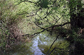
Fanno Creek is a 15-mile (24 km) tributary of the Tualatin River in the U.S. state of Oregon. Part of the drainage basin of the Columbia River, its watershed covers about 32 square miles (83 km2) in Multnomah, Washington, and Clackamas counties, including about 7 square miles (18 km2) within the Portland city limits.

Jackson F. Kimball State Recreation Site is a state park in southern Oregon. The park is operated and maintained by the Oregon Parks and Recreation Department, and is located approximately 20 miles (32 km) southeast of Crater Lake National Park and 3 miles (4.8 km) north of Fort Klamath. The park was established in 1955, and covers 19 acres (7.7 ha) including the headwaters of the Wood River.

The Wood River is a short river in the southern region of the U.S. state of Oregon, and part of the Klamath Basin drainage. It flows 18 miles (29 km) through the Fremont-Winema National Forests, Bureau of Land Management land, and private property in southern Oregon. Its watershed consists of 220 square miles (570 km2) of conifer forest, rural pasture land, and marsh. The river provides habitat for many species of wildlife including an adfluvial (migratory) and resident populations of native Great Basin redband trout.
Pine Grove is an unincorporated community in Klamath County, Oregon, United States. Pine Grove lies south of Oregon Route 140 just east of its interchange with Oregon Route 39 near Altamont.
Olene is an unincorporated community in Klamath County, Oregon, United States. It is 10 miles (16 km) southeast of Klamath Falls on Oregon Route 140. Olene currently has a general store and at one time it had a school. In 1940 Olene had a population of 62 and was considered a suburb of Klamath Falls. Olene was the center of a prosperous dairy and potato farming district.
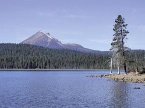
Lake of the Woods is a natural lake near the crest of the Cascade Range in the Fremont–Winema National Forest in southern Oregon in the United States. The lake covers 1,146 acres (4.64 km2). It was named by Oliver C. Applegate in 1870. Today, the Oregon Department of Fish and Wildlife manages the lake's fishery. The small unincorporated community of Lake of the Woods is located on the east shore of the lake. Lake of the Woods is one of southern Oregon's most popular outdoor recreation sites.
The transportation system of Oregon is a cooperation of complex systems of infrastructure.

Hager Mountain is a volcanic peak in Oregon in the northwest corner of the Basin and Range Province in the United States. The mountain is located south of the small unincorporated community of Silver Lake in south-central Oregon, and it is in the Fremont–Winema National Forest. On the summit, there is a fire lookout operated during the summer and fall by the United States Forest Service. There are several hiking trails that lead to the lookout station.
Hildebrand is an unincorporated community in Klamath County, Oregon, United States. It lies along Bliss Road off Oregon Route 140 northeast of Dairy.

The Oregon, California and Eastern Railway (OC&E) was a 64-mile (103 km) rail line between Klamath Falls and Bly in the U.S. state of Oregon. After 70 years of bringing logs from nearby forests to local sawmills, the former railroad right of way was converted to the OC&E Woods Line State Trail.


