
Bly is an unincorporated community in Klamath County, Oregon, United States. By highway, it is about 50 miles (80 km) east of Klamath Falls. As of 2020, the population was 207.
Beatty is an unincorporated community and census-designated place (CDP) in Klamath County, Oregon, United States. Beatty is along Oregon Route 140 at the confluence of the Sycan and Sprague rivers and is 40 miles (64 km) by highway northeast of Klamath Falls.
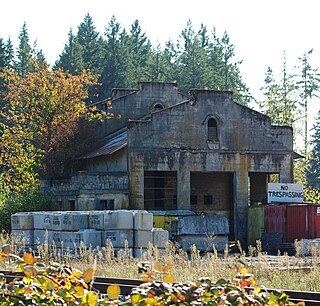
Sprague River is an unincorporated community in Klamath County, Oregon, United States. It is about 45 miles (72 km) northeast of Klamath Falls near the Sprague River, northwest of Oregon Route 140.
Dairy is an unincorporated community in Klamath County, Oregon, United States.

The OC&E Woods Line State Trail is a rail trail in Klamath and Lake counties in the U.S. state of Oregon. It is Oregon's longest state park. The trail follows the old OC&E and Weyerhaeuser railroads from Klamath Falls to Thompson Reservoir. Along its 105-mile (169 km) length it passes through the communities of Olene, Sprague River, Dairy, Beatty, and Bly.

Algoma is an unincorporated community on the east shore of Upper Klamath Lake, in Klamath County, Oregon, United States. It is about 8 miles (13 km) north of the city of Klamath Falls on U.S. Route 97. Algoma was named for the Algoma Lumber Company.

Lake of the Woods is an unincorporated community in Klamath County, Oregon, United States. It is located on the east shore of the lake of the same name within the Winema National Forest, about a mile south of Oregon Route 140.
Pine Grove is an unincorporated community in Klamath County, Oregon, United States. Pine Grove lies south of Oregon Route 140 just east of its interchange with Oregon Route 39 near Altamont.

Walden is an unincorporated community in Lane County, Oregon, United States. It is about 3 miles (5 km) southeast of Cottage Grove, near the confluence of the Row River and Mosby Creek.

Manhattan Beach State Recreation Site is a state park in the U.S. state of Oregon. Administered by the Oregon Parks and Recreation Department, the park is open to the public and is fee-free. Amenities at the park, which is 2 miles (3 km) north of Rockaway Beach along U.S. Route 101, include picnicking, fishing, and a Pacific Ocean beach.
Wyeth is an unincorporated locale in Hood River County, Oregon, United States. It is the site of a campground area in the Columbia River Gorge National Scenic Area off Interstate 84 (I-84).
Odessa is an unincorporated community in Klamath County, Oregon, United States. Odessa is along Oregon Route 140 south of Rocky Point and about 25 miles (40 km) northwest of Klamath Falls. Odessa lies along the western shore of Upper Klamath Lake near the Fremont–Winema National Forest.
Tonquin is an unincorporated locale in Washington County, Oregon, United States.
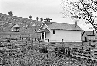
Olene is an unincorporated community in Klamath County, Oregon, United States. It is 10 miles (16 km) southeast of Klamath Falls on Oregon Route 140. Olene currently has a general store and at one time it had a school. In 1940 Olene had a population of 62 and was considered a suburb of Klamath Falls. Olene was the center of a prosperous dairy and potato farming district.
Worden is an unincorporated community in Klamath County, Oregon, United States. It is about 14 miles (23 km) south of Klamath Falls and 3 miles (5 km) north of the Oregon–California border on U.S. Route 97.

Rocky Point is an unincorporated community in Klamath County, Oregon, United States. It is on Pelican Bay on the west shore of Upper Klamath Lake, about 29 miles (47 km) northwest of Klamath Falls and about 3 miles (5 km) north of Oregon Route 140 on Forest Highway 34. It is within the Winema National Forest.
Hager is an unincorporated community in Klamath County, Oregon, United States. It is between Klamath Falls and Olene along Oregon Route 39 and Oregon Route 140.

The Oregon, California and Eastern Railway (OC&E) was a 64-mile (103 km) rail line between Klamath Falls and Bly in the U.S. state of Oregon. After 70 years of bringing logs from nearby forests to local sawmills, the former railroad right of way was converted to the OC&E Woods Line State Trail.
Hadleyville is an unincorporated community in Lane County, Oregon, United States. It is located about two miles southeast of Crow along Territorial Highway, near Coyote Creek.


