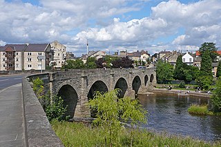
Wetherby is a market town and civil parish within the City of Leeds metropolitan borough, in West Yorkshire, England, close to the county's border with North Yorkshire and lies approximately 12 miles from Leeds, 12 mi (19 km) from York and 8 mi (13 km) from Harrogate. The town stands on the River Wharfe, and for centuries has been a crossing place and staging post on the Great North Road midway between London and Edinburgh.

Clapham Park is an area in the Borough of Lambeth in London, to the south of central Clapham and west of Brixton.

Wortley is an inner city area of Leeds, West Yorkshire, England. It begins one mile to the west of the city centre. The appropriate City of Leeds ward is called Farnley and Wortley.

Harehills is an inner-city area of east Leeds, West Yorkshire, England. It is approximately 1 mile (1.6 km) north east of Leeds city centre. Harehills is situated between the A58 and the A64. It sits in the Gipton & Harehills ward of Leeds City Council and the Leeds East parliamentary constituency, between Burmantofts and Gipton, and adjacent to Chapeltown.

Seacroft is an outer-city suburb/township consisting mainly of council estate housing covering an extensive area of east Leeds, West Yorkshire, England. It lies in the LS14 Leeds postcode area, around 4 miles (6.4 km) east of Leeds city centre.
Roundhay is a large suburb in north east Leeds, West Yorkshire, England. Roundhay had a population of 22,546 in 2011.

Gipton is a suburb of east Leeds, West Yorkshire, England, between the A58 to the north and the A64 to the south.

West Park is a suburb of north-west Leeds, West Yorkshire, England, north of Headingley. It is a mixed area of private suburban housing and suburban council estates. The name derives from its main park containing playing fields together with a conservation area of grassy meadow ending in woodland. The largest housing estate in West Park is Moor Grange.
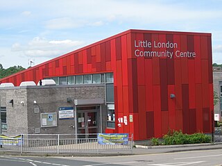
Little London is a residential area of Leeds in England, north of the city centre and Leeds Inner Ring Road. It is so called because in the 19th century it had fashionable housing and interesting architecture comparable with London. In the 1950s and '60s it became largely council housing and now consists of a mixture of high-rise and low rise flats and houses. The area falls within the Little London and Woodhouse ward of the City of Leeds Council. The area is divided into four estates; Lovell Park, Oatlands, Carlton and the Servias.

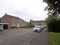
Holt Park is a medium-sized low-rise 1970s housing estate in the northwest suburbs of Leeds, West Yorkshire, England. It is approximately 6 miles (10 km) from Leeds city centre situated between Tinshill, Cookridge and Adel, and is at the edge of the Leeds urban fringe, bordering the green belt which makes up two thirds of the metropolitan borough of the City of Leeds. The nearby Tinshill BT Tower dominates the skyline.
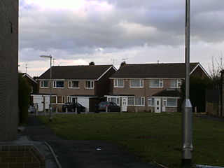
Ashtons was a housebuilder in Yorkshire in the 1950s, 1960s and 1970s.
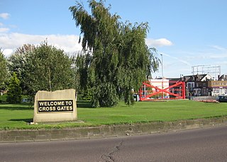
Cross Gates is a suburb in east Leeds, West Yorkshire, England.
Halton Moor is a district of east Leeds, West Yorkshire, England, about three miles east of Leeds city centre close to the A63. It is situated between Killingbeck to the north, Temple Newsam to the south, Osmondthorpe to the west and Halton and Colton to the east.

Wetherby High School is a secondary school and Sixth Form college in the Hallfield area of Wetherby, West Yorkshire, England.
The recorded history of Wetherby, a market town in the City of Leeds metropolitan borough, West Yorkshire, England, began in the 12th and 13th centuries when the Knights Templar and later the Knights Hospitallers were granted land and properties in Yorkshire. The preceptory founded in 1217 was at Ribston Park. In 1240 the Knights Templar were granted by Royal Charter of Henry III the right to hold a market in Wetherby. The charter stated the market should be held on Thursdays and an annual fair was permitted lasting three days over the day of St James the Apostle.

The architecture of Leeds, a city and metropolitan borough in West Yorkshire, England, encompasses a wide range of architectural styles and notable buildings. As with most northern industrial centres, much of Leeds' prominent architecture is of the Victorian era. However, the City of Leeds also contains buildings from as early as the Middle Ages such as Kirkstall Abbey, one of Britain's best preserved ruined Cistercian monasteries, as well as examples of 20th century industrial architecture, particularly in the districts of Hunslet and Holbeck.

Seacroft pre-dates the Domesday book, with evidence of a settlement in the area from the Neolithic Age. Seacroft remained largely unchanged for centuries as a small Yorkshire village, until in the 1950s the area was developed into Leeds' largest council estate. In the 1960s and 1970s the building of Whinmoor and Swarcliffe enclosed Seacroft within other suburbs.

Ainsty is an area of Wetherby, West Yorkshire, England. Ainsty is in the north of Wetherby and runs as far as the border between North and West Yorkshire, to the north of this is Kirk Deighton.

The Golden Triangle is a term commonly used by estate agents for the area of West and North Yorkshire lying between Harrogate, York and North Leeds. The areas of the Golden Triangle are all part of the Leeds City Region. Lying in the centre of this area is Wetherby on the fringes of West Yorkshire. Despite mainly being an affluent area the area does consist of some deprived areas such as Swarcliffe, Cranmer Bank and Hallfields. The most expensive street in the golden triangle is Fulwith Mill Lane on the South Side of Harrogate, where the average house price is £1.7 million.

Chapel Allerton is an inner suburb of north-east Leeds, West Yorkshire, England, 2 miles (3.2 km) from the city centre.