
The Tungabhadra River is a river in India that starts and flows through the state of Karnataka during most of its course, before flowing along the border between Telangana, Andhra Pradesh and ultimately joining the Krishna River near Gundimalla village in Jogulamba Gadwal district of Telangana.
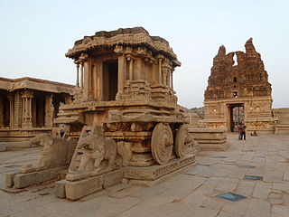
Koppala district, officially known as Koppala district is an administrative district in the state of Karnataka in India. In the past Koppal was referred to as 'Kopana Nagara'. Hampi, a World heritage center, covers some areas of Koppala District. It is situated approximately 38 km away. Anegundi, is also a famous travel destination.
Harihara is a city in Davanagere District in the Indian state of Karnataka. It is the administrative headquarters of the Harihara Taluk. Harihara is famous for Harihareshwara temple, also known as "Dakshina Kashi", and as the "Industrial Hub of central Karnataka."

Gadag is a district in the state of Karnataka, India. It was formed in 1997, when it was split from Dharwad district. As of 2011, it had a population of 1064570. The overall population increased by 13.14 percent from 1991 to 2001. Gadag district borders Bagalkot district on the north, Koppal district on the east, Vijayanagara district on the southeast, Haveri district on the southwest, Dharwad district on the west and Belgaum District on the northwest. It is famous for the many monuments from the Western Chalukya Empire. It has seven talukas: Gadag, Gajendragad, Ron, Shirhatti, Nargund, Lakshmeshwar and Mundargi.
Kaladgi is a panchayat village in the Bagalkot Taluk, Bagalkot District of Karnataka State and is located about 25 km by road west of the town of Bagalkot. Kaladgi is well known for its fruit gardens.

Gajendragad is a town and a sub-district place in Gadag District, Karnataka, India. This place is known for its hill station and hill strip. Highest populated city after Gadag in the district. It is about 55 kilometers from the district head quarter Gadag, 110 kilometers from Hubballi, 200 kilometers from Belagavi and 450 kilometers from state capital Bengaluru.
Huvina Hadagali is a town in Vijayanagara district.
Mundaragi is a municipal town in Gadag district in the Indian state of Karnataka. Mundargi is close to two district headquarters, being 36 kilometres (22 mi) from Gadag and 50 kilometres (31 mi) from Koppal. It is 99 kilometers from Gajendragad. Mundargi is also the taluka headquarter of the same name. Pin code of Mundaragi is 582118.
Ron is a taluka headquarters in Gadag district, Karnataka in India. Of historical importance, the town was termed Dronapur in ancient times. The temples are believed to be constructed by the ancient architect and warrior-priest Dronacharya.
Shiggaavi is a municipal town in Haveri district in the Indian state of Karnataka.

Karnataka, the sixth largest state in India, has been ranked as the third most popular state in the country for tourism in 2014. It is home to 507 of the 3600 centrally protected monuments in India, the largest number after Uttar Pradesh. The State Directorate of Archaeology and Museums protects an additional 752 monuments and another 25,000 monuments are yet to receive protection. Tourism centres on the ancient sculptured temples, modern cities, the hill ranges, forests and beaches etc. Broadly, tourism in Karnataka can be divided into four geographical regions: North Karnataka, the Hill Stations, Coastal Karnataka and South Karnataka.
Shirahatti is a panchayat town in Gadag district in the Indian state of Karnataka.
Balehosur is a village in the Lakshmeshwar taluk of Gadag district in the Indian state of Karnataka.
Hirewaddatti is a village in the southern state of Karnataka, India. It is located in the Mundargi taluk of Gadag district in Karnataka.
Kotumachagi is a village located in the Gadag taluk, Gadag district of Karnataka state, India. It is approximately 23 km from the district headquarters.
Havanur is a village in the southern state of Karnataka, India. It is located in the Haveri taluk of Haveri district in North Karnataka.
Kalikadevi Tempal. Mukkunda is a village in the Sindhanur taluk of the Raichur district in Karnataka, India. It is located on the banks of the Tungabhadra river. Mukkunda has several ancient temples, including the Sri Rama mandir shri dhurgamma temple, the Murari Ranga, and the Baajeshwara. The Tungabhadra river surrounds an Eshwara temple built in Hoysala style during the Sindha dynasty. A Sufi saint, hazrat gadde Khadar Bhasha darga Mukkunda is well known, and many visitors from surrounding village will come to take the blessings of this saint. It is and 27 km from Karnataka State Highway 19. The nearest towns are Siruguppa and Karatagi.
Korlahalli is a village in the Mundargi taluk of Gadag district in the Indian state of Karnataka. Korlahalli is located south to district headquarters Gadag and Taluka headquarters Mundargi.
Tippapura also spelled as Thippapura, is a village in the Mundargi taluk of Gadag district in the Indian state of Karnataka. Tippapura is located south to district headquarters Gadag and Taluka headquarters Mundargi.
Singatalur is a village in the Mundargi taluk of Gadag district in the Indian state of Karnataka. Singatalur is located south to district headquarters Gadag and Taluka headquarters Mundargi.

