Haveri is a district in the state of Karnataka, India. As of 2011, it had a population of 1,597,668, out of which 20.78% were urban residents. The district headquarters is Haveri.

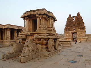
Koppala district, officially known as Koppala district is an administrative district in the state of Karnataka in India. In the past Koppal was referred to as 'Kopana Nagara'. Hampi, a World heritage center, covers some areas of Koppala District. It is situated approximately 38 km away. Anegundi, is also a famous travel destination.

Belagavi (Belgaum) division is one of the four divisions of Karnataka state of India. The division comprises the districts of Bagalkot, Belgavi, Vijaypura, Dharwad, Gadag, Haveri and Uttara Kannada. It covers a geographical area of 44,538 square kilometres (17,196 sq mi) and had a population of 13,499,721 at the 2011 census. The population density of the division was 239 per square kilometre (620/sq mi).

Gadag is a district in the state of Karnataka, India. It was formed in 1997, when it was split from Dharwad district. As of 2011, it had a population of 1064570. The overall population increased by 13.14 percent from 1991 to 2001. Gadag district borders Bagalkot district on the north, Koppal district on the east, Vijayanagara district on the southeast, Haveri district on the southwest, Dharwad district on the west and Belgaum District on the northwest. It is famous for the many monuments from the Western Chalukya Empire. It has seven talukas: Gadag, Gajendragad, Ron, Shirhatti, Nargund, Lakshmeshwar and Mundargi.

Lakkundi, also referred to as Lokkugundi, was a major city prior to the 14th century, and is now a village in Gadag District of Karnataka, India. By 10th century, it was already a major economic and commerce center with mint operations for South India, one mentioned in Kannada and Sanskrit inscriptions and texts. By 12th century, many Hindu and Jain temples had been consecrated here, along with public infrastructure such as stepwells and water reservoirs. Among the major temples are the Brahma Jinalaya (oldest), Mallikarjuna, Lakshminarayana, Manikeshwara, Naganatha, Kumbheshvara, Nanneshwara, Someshwara, Narayana, Nilakanteshwara, Kasivisesvara, Virabhadhara, Virupaksha, and others. As its importance and wealth grew, Lakkundi became one of the capitals of the Hoysala Empire.

North Karnataka is a geographical region in Deccan plateau from 300 to 730 metres elevation that constitutes the region of the Karnataka state in India and the region consists of 13 districts. It is drained by the Krishna River and its tributaries the Bhima, Ghataprabha, Malaprabha, and Tungabhadra. North Karnataka lies within the Deccan thorn scrub forests ecoregion, which extends north into eastern Maharashtra.

Dharwad or Dharawada is an administrative district of the state of Karnataka in southern India. The administrative headquarters of the district is the city of Dharwad, also known as Dharwar. Dharwad is located 425 km northwest of Bangalore and 421 km southeast of Pune, on the main highway between Chennai and Pune, the National Highway 4 (NH4).

Gadag-Betageri is a city municipal council in Gadag district in the state of Karnataka, India. It is the administrative headquarters of Gadag District. The original city of Gadag and its sister city Betageri have a combined city administration. The municipality of Gadag-Betageri has a population of 172,813 and an area of 54.0956 km2 (20.8864 sq mi). Kanaginahal of Gadag is the birthplace of the first co-operative society in Asia. The temples of Veera Narayana and Trikuteshwara are places of religious and historic importance.

Lakshmeshwara is a town, and newly created Taluk place along with Gajendragad in Gadag district, in the Indian state of Karnataka. It is about 40 km from Gadag and 55 km from Hubli. It is an agricultural trading town. Lakshmeshwara Temple dedicated to Shiva. There are many important temples in this historic town, including the other Shiva temple, the Someshwara Temple. There are two ancient Jain temples in the town, as well as a notable Jamma Masjid. Lakshmeshwara is also home for many smaller shrines, a dargah, the Kodiyellamma temple, the Mukha Basavanna shrine, and a gigantic idol of Suryanarayana.
Ron is a taluka headquarters in Gadag district, Karnataka in India. Of historical importance, the town was termed Dronapur in ancient times. The temples are believed to be constructed by the ancient architect and warrior-priest Dronacharya.
Shiggaavi is a municipal town in Haveri district in the Indian state of Karnataka.

Sudi, is a panchayat town in the Gadag District of Karnataka, India. It is about 30 km from Badami, 12 km from Gajendragad and 3 km from Itagi Bhimambika temple. In the past it was an important town of the Kalyani Chalukyas during 1000 AD. It is notable for rare stone carved monuments like Twin towered temple, Mallikarjuna temple and nagakunda , and few other structural temples. For long time these structures were abandoned, but recently they caught the eye of the Indian Archaeological Department.

Kuknoor is a town in Kukanoor taluk in the Koppal District of the Indian state of Karnataka, which is located about 40 km northwest of Hospet and 7 km from the Mahadeva Temple in Itagi. Kuknoor is known for the temples of the Rashtrakutas and Chalukyas in the town, with the most notable being the Navalinga Temple.
Savadi is a village in the southern state of Karnataka, India. It is located in the Athani taluk of Belgaum district. Located on the banks of the Krishna river, also called Uttaravahini - which flows northwards at Savadi, most of the population here is largely dependent on agriculture for its sustenance. Animals domesticated are buffaloes, goats, dogs, horse, bullocks, sheep and fowl. Historically being a belt of Jowar cultivation, with the recent irrigation projects near the village, from the past two decades, the chief crop has been sugarcane. Savadi is closely located to many sugar industries of the Krishna basin, and is part of the major supplier belt of sugarcane in Athani Taluk, and consequently Belgaum district.
Shelawadi or Shelavadi is a panchayat town in the southern state of Karnataka, India. It is located in the Navalgund taluk of Dharwad district in Karnataka.

Belavanaki is a village in southern state of Karnataka, India. It is located in Ron Taluka of Gadag district in Karnataka. It belongs to Belagavi Division.
Holealur also spelled as Holealooru is a Large village in the Ron taluk of Gadag district in the Indian state of Karnataka.

Kotumachagi is a village located in the Gadag taluk, Gadag district of Karnataka state, India. It is approximately 23 km from the district headquarters.
Soratur also spelled as Soratooru is a village in the Gadag taluk of Gadag district in the Indian state of Karnataka. It is located in the Gadag taluk of Gadag district in Karnataka.
Karnataka is a state in the southern part of India. It was created on 1 November 1956, with the passing of the States Reorganisation Act. Karnataka is bordered by the Arabian Sea to the west, Goa to the north-west, Maharashtra to the north, Telangana and Andhra Pradesh to the east, Tamil Nadu to the south-east, and Kerala to the south-west. The state covers an area of 74,122 sq mi (191,976 km2), or 5.83% of the total geographical area of India. It comprises 30 districts. Kannada is the official language of Karnataka and as per the 2011 census is the mother tongue of 66.5% of the population. Various ethnic groups with origins in other parts of India have unique customs and use languages at home other than Kannada, adding to the cultural diversity of the state. Significant linguistic minorities in the state in 2011 included speakers of Urdu (10.8%), Telugu (5.8%), Tamil (3.5%), Marathi (3.4%), Hindi (3.2%), Tulu (2.6%), Konkani (1.3%) and Malayalam (1.3%).


