Hammonds Plains, Nova Scotia

Last updated

Hammonds Plains
Suburban Community
Canada Nova Scotia location map 2.svg
Red pog.svg
Location within Nova Scotia
Coordinates: 44°44′02″N63°46′32″W / 44.73389°N 63.77556°W / 44.73389; -63.77556
CountryFlag of Canada (Pantone).svg  Canada
Province Flag of Nova Scotia.svg  Nova Scotia
Municipality Halifax
CommunityHammonds Plains
Municipal District District 13 (Hammonds Plains-St. Margaret's)
Area
[1]
  Total33.31 km2 (12.86 sq mi)
Area code 902

Hammonds Plains is a suburban area of the Halifax Regional Municipality in Nova Scotia, Canada, located 20 km northwest of Downtown Halifax.

Contents

History

Hammonds Plains was established as a settlement for United Empire Loyalists in 1786 along a road running from Birch Cove on Bedford Basin to St. Margaret's Bay. Landowners voted to name the road after the popular outgoing Lt. Governor Andrew Snape Hamond. [2] Further settlers arrived with disbanded soldiers from the Napoleonic Wars and Black Refugees from the War of 1812. The settlement was also the eastern end of the Old Annapolis Road intended to create a settled corridor and transportation link between Halifax and Annapolis Royal. While the Annapolis Road never developed, settlement opened up the a modest amount of viable farmland and more significantly developed many saw mills.

During the 1950s, Hammonds Plains was a potential location for a new international airport for Halifax, where the airport would've been constructed between the present day Glen Arbour Subdivision and Lucasville. The airport was ultimately built in Goffs, just south of Enfield, Nova Scotia.

Geography

Canada Nova Scotia location map 2.svg
Red pog.svg
Hammonds Plains in Nova Scotia

The Government of Nova Scotia defines Hammonds Plains as adjacent to Bedford-and-Lucasville to the east; Upper Sackville-and-Middle Sackville to the north; Stillwater Lake, Timberlea, and Upper Tantallon to the south; and Upper Hammonds Plains to the west. [3] The community is situated along the isthmus of the Chebucto Peninsula with its centre located along Highway 213 (Hammonds Plains Road).

The Hammonds Plains region is rich in small lakes and is a dormitory area for Halifax. Many homes lie on large unserviced lots, except in the Kingswood subdivision where 90% of the units have municipal water service and along the Hammonds Plains Road itself where there are several small businesses involved in automobile repair, waste management, physiotherapy clinics, and other maintenance activities. The population grew rapidly in the 1990s, particularly in subdivisions at the western end of the Hammonds Plains Road. Halifax's water comes from Pockwock Lake which lies north of Hammonds Plains. The landmass of Hammonds Plains is approximately 3,331 ha (8,230 acres). [4]

Residential subdivisions

Activities

An annual cycling event called Close To Home: The Tour of Hammonds Plains links the earliest settled areas with the new subdivisions.

Demographics

Hammonds Plains is a well-established community—however—the demographic information available from Statistics Canada pertains to the settled area ("retired population centre") of Hammonds Plains Road, not the community of Hammonds Plains.[ clarification needed ]

The settled area ("retired population centre") of Hammonds Plains Road had a population of 1,819 people living in 595 of its 602 total private dwellings as of 2021, a decrease of

Transportation

Halifax Transit's route 433 serves Hammonds Plains. [6] This route travels from Tantallon, passes through Hammonds Plains, and continues to the Lacewood Terminal in Clayton Park. At Lacewood Terminal, passengers can transfer to buses destined for other areas of Halifax.

Education

Schools that service residents of Hammonds Plains include:

Services Blue Mountain Estates, Kingswood, and Kingswood North

Services Cedarwood, Glen Arbour, Highland Park, Maplewood, and White Hills

Notable residents

Related Research Articles

<span class="mw-page-title-main">Bedford, Nova Scotia</span> District of Halifax, Nova Scotia, Canada

Bedford is a former town and now a district of Halifax, Nova Scotia, Canada. It is situated on the north west shore of the Bedford Basin in the central area of the municipality. It borders the neighbouring communities of Hammonds Plains to the west, Sackville to the north, Dartmouth to the east, and Main Land Halifax to the south. Bedford was named in honour of John Russell, 4th Duke of Bedford, Secretary of State for the colonies in 1749.

<span class="mw-page-title-main">Lower Sackville, Nova Scotia</span> Community in Nova Scotia, Canada

Lower Sackville is a suburban community of the Halifax Regional Municipality, Nova Scotia, Canada.

<span class="mw-page-title-main">Chester-St. Margaret's</span> Provincial electoral district in Nova Scotia, Canada

Chester—St. Margaret's is a provincial electoral district in Nova Scotia, Canada, that elects one member of the Nova Scotia House of Assembly. It is located on the South Shore.

Highway 102 is a north–south highway in the Canadian province of Nova Scotia that runs from Halifax to Onslow, immediately north of the town of Truro. It is the busiest highway in Atlantic Canada.

Rockingham is a community located within the urban area of the Halifax Regional Municipality, in Nova Scotia, Canada.

<span class="mw-page-title-main">Sir Andrew Hamond, 1st Baronet</span> British politician

Captain Sir Andrew Snape Hamond, 1st Baronet was a British naval officer and Lieutenant Governor of Nova Scotia from 1781 to 1782 and Comptroller of the Navy from 1794 to 1828.

<span class="mw-page-title-main">Timberlea-Prospect</span> Provincial electoral district in Nova Scotia, Canada

Timberlea—Prospect is a provincial electoral district in Nova Scotia, Canada, that elects one member of the Nova Scotia House of Assembly. Its Member of the Legislative Assembly (MLA) since 2013 has been Iain Rankin of the Nova Scotia Liberal Party.

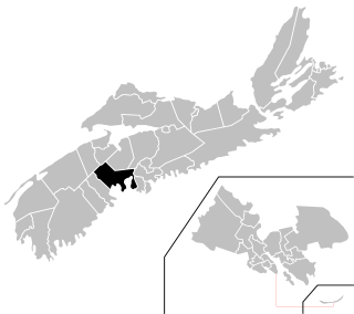
Hammonds Plains—Upper Sackville is a former provincial electoral district in Nova Scotia, Canada, which existed from 2003 to 2013. It elected one member of the Nova Scotia House of Assembly. In its last configuration, the electoral district included those communities comprising the western suburbs of the Halifax Regional Municipality, namely Hammonds Plains, Yankeetown, Pockwock, Upper Sackville and Lucasville.

<span class="mw-page-title-main">Nova Scotia Trunk 1</span> Highway in Nova Scotia

Trunk 1 is part of the Canadian province of Nova Scotia's system of Trunk Highways.

The Halifax Regional Centre for Education is the public school district responsible for 136 elementary, junior high, and high schools located in the Halifax Regional Municipality. The current Regional Executive Director is Steve Gallagher. The district's office is on Spectacle Lake Drive in Dartmouth. The district's stated vision is "to provide a high quality education to every student every day". On January 24, 2018, the provincial government announced that the Halifax Regional School Board would be dissolved and that kindergarten to grade 12 education services in Halifax would administered by an appointed provincial council. The Halifa Regional School Board was dissolved on March 31, 2018.

Route 213 is a collector road in the Canadian province of Nova Scotia. It is located in the Halifax Regional Municipality, connecting Bedford at Trunk 2 with Upper Tantallon at Trunk 3 with interchanges with Highway 102 and Highway 103 located near the termini.

<span class="mw-page-title-main">Nova Scotia Route 333</span>

Route 333 is a collector road in the Canadian province of Nova Scotia.

<span class="mw-page-title-main">Tantallon, Nova Scotia</span> Suburban Community in Halifax Regional Municipality, Nova Scotia, Canada

Tantallon is an exurban community in Halifax Regional Municipality, Nova Scotia, Canada. It extends from about two kilometers south of Trunk 3, along Route 333, just north of Ballfield Road, for roughly three kilometres along Route 333, to just south of Longards road, and includes Whynachts Point and Sheeps Head Island. It is bordered to the north by Upper Tantallon and to the south by Glen Haven. The community is about 32 km (20 mi) from Downtown Halifax.

<span class="mw-page-title-main">Hammonds Plains, Upper Sackville and Beaverbank, Nova Scotia</span> Planning Area in Nova Scotia, Canada

Hammonds Plains, Upper Sackville and Beaver Bank is a planning area in the Halifax Regional Municipality, Nova Scotia. The area wraps from Exit 5 on Highway 103 to the west of the urban core of Halifax, and runs north and east, wrapping clockwise around the harbour along the Hammonds Plains Road, Lucasville Road and Sackville Drive, through Upper Sackville to Beaverbank.

<span class="mw-page-title-main">Sackville River</span> River in Nova Scotia, Canada

The Sackville River is a river in Hants County and Halifax Regional Municipality, Nova Scotia, Canada. It empties into Bedford Basin. The Little Sackville River is a tributary.

<span class="mw-page-title-main">Clayton Park West (electoral district)</span> Provincial electoral district in Nova Scotia, Canada

Clayton Park West is a provincial electoral district in Nova Scotia, Canada, that elects one member of the Nova Scotia House of Assembly.

Upper Hammonds Plains is a Canadian suburban community located in Nova Scotia's Halifax Regional Municipality.

References

  1. "History of Hammonds Plains". hammondsplainshistoricalsociety.ca. Hammonds Plains Historical Society. Retrieved 23 September 2021.
  2. Hamond, Andrew Snape, Dictionary of Canadian Biography
  3. "NSCAF Civic Address Finder". Department of Service Nova Scotia and Municipal Relations.{{cite web}}: Missing or empty |url= (help)
  4. "History of Hammonds Plains". hammondsplainshistoricalsociety.ca. Hammonds Plains Historical Society. Retrieved 23 September 2021.
  5. "Population and dwelling counts: Canada and designated places". Statistics Canada. February 9, 2022. Retrieved May 9, 2022.
  6. "Routes & Schedules". halifax.ca. Government of the Municipality of Halifax. Retrieved 3 August 2022.