Hampton Bays, New York

Last updated

Hampton Bays, New York
Ponquogue-bridge.jpg
Ponquogue Bridge over Shinnecock Inlet (new span on left) looking toward the Coast Guard station.
Flag of Hampton Bays, New York.png
Hampton-bays-map.gif
USA New York location map.svg
Red pog.svg
Hampton Bays, New York
Coordinates: 40°52′26″N72°31′16″W / 40.87389°N 72.52111°W / 40.87389; -72.52111
Country Flag of the United States.svg  United States
State Flag of New York.svg  New York
County Suffolk
Town Southampton
Area
[1]
  Total20.51 sq mi (53.12 km2)
  Land12.94 sq mi (33.50 km2)
  Water7.57 sq mi (19.61 km2)
Elevation
33 ft (10 m)
Population
 (2020)
  Total15,228
  Density1,177.27/sq mi (454.54/km2)
Time zone UTC−05:00 (Eastern Time Zone)
  Summer (DST) UTC−04:00
ZIP Code
11946
Area code(s) 631, 934
FIPS code 36-31896
GNIS feature ID0952135

Hampton Bays is a hamlet and census-designated place (CDP) in the Town of Southampton in Suffolk County, on Long Island, in New York. It is considered as part of the region of Long Island known as The Hamptons. The population was 13,603 at the 2010 census. [2]

Contents

History

The hamlet was settled in 1740 as "Good Ground", which became the main hamlet of eleven in the immediate area. [3] [4] The area where Main Street, also known as Montauk Highway, is located today, was the approximate area of the original hamlet.[ citation needed ]

There were ten other hamlets in the area. They were called Canoe Place, East Tiana, Newtown, Ponquogue, Rampasture, Red Creek, Squiretown, Southport, Springville, and West Tiana. Most of these hamlets were settled by one or two families and had their own school house. Many of the names from the former hamlets are still featured as local street names today.[ citation needed ]

As a result of the growth of the surrounding hamlets and villages in the Hamptons and increased tourism from New York City, the eleven hamlets, although generally called "Good Ground" collectively by the early part of the 20th century, amalgamated under the name "Hampton Bays" in 1922. [3] The motive behind the name change was for the hamlet to benefit from the "Hamptons" trade that the community's neighbors were experiencing.[ citation needed ]

In the early 1970s and the 2010s, portions of Hampton Bays unsuccessfully attempted to incorporate itself as the Incorporated Village of Hampton Bays. [5] [6] [7]

Geography

According to the U.S. Census Bureau, the CDP has a total area of 18.1 square miles (47.0 km2), of which 12.9 square miles (33.5 km2) is land and 5.2 square miles (13.4 km2), or 28.54%, is water. [2] [8] The hamlet is surrounded by three bays, the Peconic Bay to the north, and Shinnecock and Tiana bays to the south. The two southern bays are a part of a greater bay system, called the Great South Bay system, which stretches from approximately Southampton Village to Jamaica Bay in New York City. The Shinnecock Canal, a man-made canal located in the eastern part of the hamlet, connects the Great Peconic Bay with the Shinnecock Bay. Shinnecock Inlet, which leads from the Shinnecock Bay to the Atlantic Ocean, is the easternmost inlet, making it very popular for commercial fishing. The inlet itself, which separates the barrier beaches of Hampton Bays from those of neighboring Southampton, was created in the 1938 New England hurricane when the forces of the hurricane washed over that area of barrier beach, connecting the waters of the Atlantic with the bay.

The Hampton Bays CDP is bounded by the Atlantic Ocean to the south; by the Shinnecock Inlet and the eastern portion of Shinnecock Bay to the east, beyond which lie the village of Southampton and the CDP of Shinnecock Hills; by Peconic Bay to the north, beyond which lie the towns of Southold and Riverhead; and by the CDPs of Flanders and East Quogue (still within the town of Southampton) to the west.

Hampton Bays is located approximately 81 miles (130 km) east of Manhattan.

Demographics

Historical population
CensusPop.Note
2020 15,228
U.S. Decennial Census [9]

As of the census [10] of 2000, there were 12,236 people, 4,877 households, and 3,092 families residing in the CDP. The population density was 1,016.1 inhabitants per square mile (392.3/km2). There were 6,875 housing units at an average density of 570.9 per square mile (220.4/km2). The racial makeup of the CDP was 92% White, 0.87% African American, 0.13% Native American, 0.70% Asian, 0.10% Pacific Islander, 3.69% from other races, and 1.55% from two or more races. Hispanic or Latino of any race were 2% of the population.

There were 4,877 households, out of which 26.4% had children under the age of 18 living with them, 50.5% were married couples living together, 8.4% had a female householder with no husband present, and 36.6% were non-families. 28.5% of all households were made up of individuals, and 13.2% had someone living alone who was 65 years of age or older. The average household size was 2.48 and the average family size was 3.00.

In the CDP, the population was spread out, with 20.8% under the age of 18, 7.8% from 18 to 24, 31.1% from 25 to 44, 23.9% from 45 to 64, and 16.5% who were 65 years of age or older. The median age was 39 years. For every 100 females, there were 98.6 males. For every 100 females age 18 and over, there were 96.3 males.

The median income for a household in the CDP was $50,161, and the median income for a family was $58,773. Males had a median income of $47,633 versus $30,426 for females. The per capita income for the CDP was $27,027. About 6.7% of families and 10.7% of the population were below the poverty threshold, including 12.9% of those under age 18 and 10.7% of those age 65 or over.

Economy

Like most of the other communities in The Hamptons, tourism is a critical component of the local economy.

Commercial fishing remains a vital part of the Hampton Bays economy, centered on the fishing station at Shinnecock Inlet. After Montauk, Hampton Bays is the second-busiest commercial fishing port in the state of New York. According to 2014 statistics by the National Marine Fisheries Service, 4.7 million pounds of finfish and shellfish, worth $5.5 million, were landed in the Hampton Bays/Shinnecock port. [11]

Hampton Bays was used as the set of the 2007 movie Margot at the Wedding starring Nicole Kidman and Jack Black.

Education

Hampton Bays is served by Hampton Bays Public Schools. [12] The district operates three schools. Hampton Bays Elementary School serves grades Pre-K-4, [13] and Hampton Bays Middle School, which fully opened in Fall 2008, serves grades 5-8. It is the first "green" school in New York state. [14] [15] Hampton Bays High School serves grades 9-12. [12]

HB Schools' athletic teams are called the "Baymen", in honor of local commercial fishermen who work the hamlet's inland waters. Team colors are purple, black and white

Media

WLIR-FM is a radio station licensed to serve Hampton Bays.

Transportation

Hampton Bays LIRR Station and two trains Hampton Bays LIRR Station; Two Trains.JPG
Hampton Bays LIRR Station and two trains

Hampton Bays is served by Sunrise Highway (NY 27), which is a major artery to the western parts of Long Island and New York City. [12] The hamlet is also served by Montauk Highway (NY 27A), which runs from Queens to Montauk. Montauk Highway serves as the "Main Street" of many hamlets and villages along the south shore of Long Island.

The Long Island Rail Road (LIRR) provides limited rail service seven days per week via the Montauk Branch connecting Hampton Bays to Montauk and New York City. Hampton Jitney and Hampton Luxury Liner coach bus services provide slightly more frequent passenger travel between New York City and Hampton Bays, especially during summer months. Local Suffolk County buses also provide service to neighboring areas.

The waterways in the area, including the Shinnecock Canal, provide invaluable routes for boats. [12]

See also

Related Research Articles

<span class="mw-page-title-main">Suffolk County, New York</span> County in New York, United States

Suffolk County is the easternmost county in the U.S. state of New York. It comprises the eastern two-thirds of Long Island, bordered to its west by Nassau County, to its east by Gardiners Bay and the Atlantic Ocean, to its north by Long Island Sound, and to its south by Great South Bay.

<span class="mw-page-title-main">Amagansett, New York</span> Hamlet in the state of New York, United States

Amagansett is a census-designated place that roughly corresponds to the hamlet by the same name in the Town of East Hampton in Suffolk County, New York, United States, on the South Shore of Long Island. As of the 2010 United States Census, the CDP population was 1,165. Amagansett hamlet was founded in 1680.

<span class="mw-page-title-main">Bay Shore, New York</span> Hamlet and census-designated place in New York, United States

Bay Shore is a hamlet and census-designated place (CDP) in the Town of Islip, New York, United States. It is situated on the South Shore of Long Island, adjoining the Great South Bay. The population of the CDP was 29,244 at the time of the 2020 census.

<span class="mw-page-title-main">East Patchogue, New York</span> Census-designated place in New York, United States

East Patchogue is a census-designated place (CDP) in the Town of Brookhaven in Suffolk County, on the South Shore of Long Island, in New York, United States. The population was 22,469 at the 2010 census. The CDP is a proximate representation of the East Patchogue hamlet used for statistical purposes of the Census Bureau.
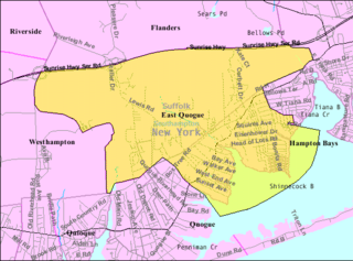
<span class="mw-page-title-main">Mastic Beach, New York</span> Hamlet and Census-designated place in New York, United States

Mastic Beach is a hamlet and census-designated place, and former village in the southeastern part of the Town of Brookhaven in Suffolk County, on Long Island, in New York, United States. The population was 14,849 at the 2010 census, when it was an unincorporated census-designated place for the first time.

<span class="mw-page-title-main">Mattituck, New York</span> Hamlet and census-designated place in New York, United States

Mattituck is a hamlet and census-designated place (CDP) in Suffolk County, New York, United States. The population was 4,584 in 2023 according to the World Population Review. Located in the Town of Southold, Mattituck CDP roughly corresponds to the hamlet by the same name.

<span class="mw-page-title-main">Peconic, New York</span> Hamlet and census-designated place in New York, United States

Peconic is a census-designated place (CDP) that roughly corresponds to the hamlet by the same name in the Town of Southold in Suffolk County, New York, United States. The CDP population was 683 at the 2010 census.

<span class="mw-page-title-main">Shinnecock Hills, New York</span> Hamlet and census-designated place in New York, United States

Shinnecock Hills is a hamlet in Suffolk County, New York, United States. The population was 2,188 at the 2010 census. It is the home of a leading golf club, Shinnecock Hills Golf Club. Ownership of the area has been the subject of a 2005 lawsuit filed by the Shinnecock Indian Nation.
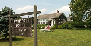
<span class="mw-page-title-main">West Hampton Dunes, New York</span> Village in New York, United States

West Hampton Dunes is an incorporated village in the Town of Southampton on Westhampton Island, in Suffolk County, New York, United States. Located off the South Shore of Long Island, the village's population was 126 at the time of the 2020 census.

<span class="mw-page-title-main">Westhampton Beach, New York</span> Village in New York, United States

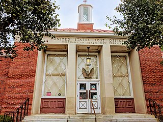
Westhampton Beach is an incorporated village in the Town of Southampton, in Suffolk County, on the South Shore of Long Island, in New York, United States. As of the 2010 census, the population was 1,721.

<span class="mw-page-title-main">The Hamptons</span> Seaside group of towns, villages and hamlets

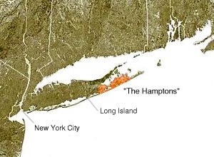
The Hamptons, part of the East End of Long Island, consist of the towns of Southampton and East Hampton, which together comprise the South Fork of Long Island, in Suffolk County, New York. The Hamptons are a popular seaside resort and one of the historical summer colonies of the northeastern United States.

<span class="mw-page-title-main">Riverhead (CDP), New York</span> Hamlet and census-designated place in New York, United States

Riverhead is a census-designated place (CDP) roughly corresponding to the hamlet by the same name located in the Town of Riverhead in Suffolk County, on Long Island, in New York, United States. The CDP's population was 13,299 at the 2010 census.

<span class="mw-page-title-main">Southampton (village), New York</span> Place in New York, United States

Southampton is an incorporated village in the Town of Southampton in Suffolk County, on the South Fork of Long Island, in New York, United States. The population was 3,109 at the 2010 census.

<span class="mw-page-title-main">Southampton, New York</span> Town in New York, United States

Southampton, officially the Town of Southampton, is a town in southeastern Suffolk County, New York, partly on the South Fork of Long Island. As of the 2020 U.S. census, the town had a population of 69,036. Southampton is included in the stretch of shoreline prominently known as the Hamptons.

<span class="mw-page-title-main">Southold, New York</span> Town in New York, United States

The Town of Southold is one of ten towns in Suffolk County, New York, United States. It is located in the northeastern tip of the county, on the North Fork of Long Island. The population was 23,732 at the 2020 census. The town also contains a hamlet named Southold, which was settled in 1640.

<span class="mw-page-title-main">Peconic County, New York</span> Hypothetical new county on Long Island, New York

Peconic County is a proposed new county on Long Island in the U.S. state of New York that would secede the five easternmost towns of Suffolk County: East Hampton, Riverhead, Shelter Island, Southampton and Southold, plus the Shinnecock Indian Reservation.

<span class="mw-page-title-main">Shinnecock Canal</span>

The Shinnecock Canal is a canal that cuts across the South Fork at Hampton Bays, New York. At 4,700 feet (1,400 m) long, it connects Great Peconic Bay and the north fork of Long Island with Shinnecock Bay and the Atlantic Ocean. The canal opened to traffic in 1892.

<span class="mw-page-title-main">Outer Barrier</span> String of barrier islands dividing Long Island from the Atlantic Ocean

The Outer Barrier, also known as the Long Island and New York City barrier islands, refers to the string of barrier islands that divide the lagoons south of Long Island, New York from the Atlantic Ocean. These islands include Long Beach Barrier Island, Barnum Island, Jones Beach Island, Fire Island and Westhampton Island. The outer barrier extends 75 miles (121 km) along the South Shore of Long Island, from the Rockaway Peninsula in New York City to the east end of Shinnecock Bay in Suffolk County.

<span class="mw-page-title-main">East End (Long Island)</span> Region of Long Island, New York, United States

The East End of Long Island is constituted by the five townships at the eastern end of New York's Suffolk County, namely Riverhead, Southampton, Southold, Shelter Island, and East Hampton. Long Island's North Fork and South Fork are part of the East End. "The East End" is sometimes shortened as "The End", but this latter term is also applied only to Montauk, the most easterly hamlet of the contiguous land mass.

References

  1. "ArcGIS REST Services Directory". United States Census Bureau. Retrieved September 20, 2022.
  2. 1 2 "Geographic Identifiers: 2010 Demographic Profile Data (G001): Hampton Bays CDP, New York". U.S. Census Bureau, American Factfinder. Archived from the original on February 12, 2020. Retrieved December 31, 2012.
  3. 1 2 Shepard, Richard F. (March 1, 1987). "ABOUT LONG ISLAND; WHAT'S IN A NAME? HISTORY". The New York Times. ISSN   0362-4331 . Retrieved August 27, 2021.
  4. "Good Ground (Suffolk County, NY)". roadsidethoughts.com. Retrieved August 27, 2021.
  5. "Hampton Bays Is Due to Vote Soon on Incorporation as Village". The New York Times. November 5, 1972. ISSN   0362-4331 . Retrieved September 13, 2022.
  6. Rattiner, Dan (June 6, 2013). "It Takes a Village? Hampton Bays Hamlet, Like Others Before It, Ponders Incorporation – Dan's Papers". www.danspapers.com. Retrieved September 13, 2022.
  7. Jackson, Erica (January 17, 2013). "Civic Eyes Forming Village of Hampton Bays". Westhampton-Hampton Bays, NY Patch. Retrieved September 13, 2022.
  8. "US Gazetteer files: 2010, 2000, and 1990". United States Census Bureau. February 12, 2011. Retrieved April 23, 2011.
  9. "Census of Population and Housing". Census.gov. Retrieved June 4, 2016.
  10. "U.S. Census website". United States Census Bureau . Retrieved January 31, 2008.
  11. NOAA Fisheries (Total Commercial Fishery Landings At Major U. S. Ports Summarized By Year and Ranked By Poundage)
  12. 1 2 3 4 "Long Island Index: Interactive Map". www.longislandindexmaps.org. Retrieved August 27, 2021.
  13. "Elementary School Grades K-4". Hampton Bays Public Schools.
  14. "Middle School - Grades 5-8". Hampton Bays Public Schools.
  15. "Hampton Bays Middle School is a GREEN School!" . Retrieved January 12, 2013.
Preceded by The Hamptons Succeeded by