Good Ground Windmill (Shelter Island Mill I) was built in 1807 on the north end of Shelter Island, New York. It was worked as a gristmill on Shelter Island until 1860. [1]
Contents

Good Ground Windmill (Shelter Island Mill I) was built in 1807 on the north end of Shelter Island, New York. It was worked as a gristmill on Shelter Island until 1860. [1]

The Good Ground mill site at 7 W. Montauk Highway was owned in the 1860s by Martin Van Buren Squires. He purchased the grist mill on Shelter Island, and had it transported by barge to the Red Creek area, and then hauled to the elevated land on the corner of Montauk Highway and Ponquogue Avenue. [2] The mill was made of hand-hewn oak logs and stood forty feet high. The first miller was Ashby, followed by Theodore Corwith, who lived in a small house on Montauk Highway in Good Ground, and then by Timothy Griffing, who lived across the street from the mill. [3] The advent of the railroad (LIRR) meant that inexpensive milled grains could be transported to Good Ground and the need for a local mill diminished. [4]
It remained in operation till around 1880, when an original founder of the Southampton summer colony, Charles Wyllys Betts, determined that the Good Ground mill would make the perfect addition to his gambrel-roofed, gable-windowed oceanside cottage on Gin Lane.
To preserve the mill structure, Wyllys Betts, of Meadow Lane, Southampton, NY, purchased and moved it to his property in 1880, [5] where it formed the basis of a weathered cape cottage with a house built around the mill. The mill was especially distinctive for its Greek Revival cap. [6]
The interior mechanisms were removed and windows and a veranda were added. The property was sold to an architect named Goodhue Livingston in 1925, and his family held it until 1989. The cottage and windmill have become an antique showplace for the current collector/owners. The mill exists there today, it is not open to the public. [7]
It was added to the NRHP by Robert J. Hefner. [8]

Suffolk County is the easternmost county in the U.S. state of New York. It comprises the eastern two-thirds of Long Island, bordered to its west by Nassau County, to its east by Gardiners Bay and the Atlantic Ocean, to its north by Long Island Sound, and to its south by Great South Bay.

Hampton Bays is a hamlet and census-designated place (CDP) in the Town of Southampton in Suffolk County, on Long Island, in New York. It is considered as part of the region of Long Island known as The Hamptons. The population was 13,603 at the 2010 census.
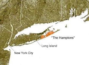
The Hamptons, part of the East End of Long Island, consist of the towns of Southampton and East Hampton, which together comprise the South Fork of Long Island, in Suffolk County, New York. The Hamptons are a popular seaside resort and one of the historical summer colonies of the northeastern United States.

Southampton, officially the Town of Southampton, is a town in southeastern Suffolk County, New York, partly on the South Fork of Long Island. As of the 2020 U.S. census, the town had a population of 69,036. Southampton is included in the stretch of shoreline prominently known as the Hamptons.

The Town of East Hampton is located in southeastern Suffolk County, New York, at the eastern end of the South Shore of Long Island. It is the easternmost town in the state of New York. At the time of the 2020 United States census, it had a total population of 28,385.

Peconic County is a proposed new county on Long Island in the U.S. state of New York that would secede the five easternmost towns of Suffolk County: East Hampton, Riverhead, Shelter Island, Southampton and Southold, plus the Shinnecock Indian Reservation.
Montauk Highway is an east–west road extending for 95 miles (153 km) across the southern shore of Long Island in Suffolk County, New York, in the United States. It extends from the Nassau County line in Amityville, where it connects to Merrick Road, to Montauk Point State Park at the very eastern end of Long Island in Montauk. The highway is known by several designations along its routing, primarily New York State Route 27A (NY 27A) from the county line to Oakdale and NY 27 east of Southampton. The portion of Montauk Highway between Oakdale and Southampton is mostly county-maintained as County Route 80 and County Route 85.
The South Fork of Suffolk County, New York is a peninsula in the southeastern section of the county on the South Shore of Long Island. The South Fork includes most of the Hamptons. The shorter, more northerly peninsula is known as the North Fork.
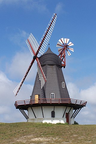
The smock mill is a type of windmill that consists of a sloping, horizontally weatherboarded, thatched, or shingled tower, usually with six or eight sides. It is topped with a roof or cap that rotates to bring the sails into the wind. This type of windmill got its name from its resemblance to smocks worn by farmers in an earlier period.

New York's 1st congressional district is a congressional district for the United States House of Representatives in eastern Long Island. It includes the eastern two-thirds of Suffolk County, including the northern portion of Brookhaven, as well as the entirety of the towns of Huntington, Smithtown, Riverhead, Southold, Southampton, East Hampton, and Shelter Island. The district encompasses extremely wealthy enclaves such as the Hamptons, middle class suburban towns such as Selden, Centereach and Lake Grove, working-class towns such as Riverhead and rural farming communities such as Mattituck and Jamesport on the North Fork. The district currently is represented by Republican Nick LaLota who lives in Amityville, outside of the district.

New York State Route 27A (NY 27A) is a state highway extending from Massapequa in Nassau County to Oakdale in Suffolk County on Long Island, New York, in the United States. Its two most prominent components are Merrick Road and Montauk Highway.

Hayground Windmill is an historic windmill at Windmill Lane in East Hampton Village, New York. It was moved from Hayground to Pantigo between Two Mile Hollow Beach and Egypt Beach in the 1950s.

Shelter Island Windmill is an historic windmill north of Manwaring Road in Shelter Island, Suffolk County, New York. It was built in 1810. Master Millwright Nathaniel Dominy V (1770–1852) was the architect and builder of the windmill. The windmill has been on Shelter Island since 1840 and at its current location since 1926 on the Sylvester Manor farm.

Hook Windmill, also known as Old Hook Mill, is a historic windmill on North Main Street in East Hampton, New York. It was built in 1806 and operated regularly until 1908. One of the most complete of the existing windmills on Long Island, the windmill was sold to the town of East Hampton in 1922. The building was listed on the National Register of Historic Places in 1978 and is part of the North Main Street Historic District. The mill was renamed the "Old Hook Mill" and is open daily to visitors.

Corwith Windmill at Water Mill is a historic mill on NY 27 and Halsey Lane in Southampton, New York.

Wainscott Windmill is an historic windmill on Georgica Association grounds in Wainscott, New York in the Town of East Hampton. Georgica Association grounds are both within Wainscott and the Village of East Hampton to the east. Historically, it is known as one of the most frequently-moved windmills on the east end. It was added to the National Historic Register in 1978.
The Shinnecock Windmill is a windmill currently located on the Stony Brook Southampton campus in Southhampton, Suffolk County, New York. Originally located on Mill Hill at Windmill Lane and Hill Street in Southampton, in 1890, it was relocated to Shinnecock Hills. The land became the campus of Southampton College in 1963, now Stony Brook Southampton.
The Tide Mill at Southold, erected in the 1640's by Thomas Benedict, holds a place of distinction in American history as the first recorded English mill in the New World. It paved the way for future tide mills and contributed to the economic growth of the Southold community..
