Dering Harbor, New York

Last updated

Dering Harbor, New York
Incorporated Village of Dering Harbor
Dering-harbor-map.png
U.S. Census map of Dering Harbor.
Suffolk County, NY, towns and villages Dering Harbor highlighted.svg
Location within Suffolk County and the state of New York.
USA New York location map.svg
Red pog.svg
Dering Harbor, New York
Coordinates: 41°5′35″N72°20′43″W / 41.09306°N 72.34528°W / 41.09306; -72.34528
Country Flag of the United States.svg  United States
State Flag of New York.svg  New York
County Suffolk
Town Shelter Island
Incorporated 1916
Government
   Mayor Karen Kelsey
   Deputy Mayor Brad Goldfarb
Area
[1]
  Total0.26 sq mi (0.67 km2)
  Land0.25 sq mi (0.64 km2)
  Water0.01 sq mi (0.03 km2)
Elevation
7 ft (2 m)
Population
 (2020)
  Total50
  Density203.25/sq mi (78.59/km2)
Time zone UTC-5 (Eastern (EST))
  Summer (DST) UTC-4 (EDT)
ZIP Code
11965
Area codes 631, 934
FIPS code 36-20379
GNIS feature ID0948345
Website deringharborvillage.org

Dering Harbor is a village in the Town of Shelter Island, in Suffolk County, New York, United States. As of the 2020 census, the village population was 50, making it the least populous village in the State of New York.

Contents

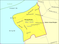
The Incorporated Village of Dering Harbor is located on the northern side of Shelter Island, east of the hamlet of Shelter Island Heights.

History

Dering Harbor incorporated as a village in 1916. [2] [3] It had been a popular resort community since the 19th Century. [2] [3] According to The New York Times , it is rumored that the village decided to incorporate as a means of preventing "Coney Island-style concessions" from popping up in the area. [3]

Geography

According to the United States Census Bureau, the village has a total area of 0.2 square miles (0.52 km2), of which 0.2 square miles (0.52 km2) is land and 4.00% is water. [4]

Demographics

Historical population
CensusPop.Note
1920 3
1930 391,200.0%
1940 34−12.8%
1950 4−88.2%
1960 19375.0%
1970 2426.3%
1980 16−33.3%
1990 2875.0%
2000 13−53.6%
2010 11−15.4%
2020 50354.5%
U.S. Decennial Census [5]

At the 2000 census there were 13 people, 6 households, and 3 families in the village. The population density was 54.1 inhabitants per square mile (20.9/km2). There were 32 housing units at an average density of 133.2 per square mile (51.4/km2). The racial makeup of the village was 92% White and 8% Native American. [6] Of the 6 households 17% had children under the age of 18 living with them, 50% were married couples living together, and 50% were non-families. 33% of households were one person and 17% were one person aged 65 or older. The average household size was 2.17 and the average family size was 3.00.

The age distribution was 15% under the age of 18, 23% from 18 to 24, 8% from 25 to 44, 31% from 45 to 64, and 23% 65 or older. The median age was 46 years. For every 100 females, there were 116.7 males. For every 100 females age 18 and over, there were 120.0 males.

The median household income was $33,750 and the median family income was $98,750. Males had a median income of $36,250 versus $0 for females. The per capita income for the village was $43,185. Nobody in the village was below the poverty line.

The village is the smallest in New York state, in terms of total population. [7]

Government

As of July 2023, the Mayor of Dering Harbor is Karen Kelsey, the Deputy Mayor is Brad Goldfarb, and the Village Trustees are Samuel Ashner, Ari Benacerraf, and Patrick Parcells. [8]

Education

School district

The Village of Dering Harbor is located entirely within the boundaries of the Shelter Island Union Free School District. [9] [10] As such, all children who reside within Dering Harbor and attend public schools go to Shelter Island's schools. [9] [10]

Library district

Dering Harbor is located within the boundaries of the Shelter Island Public Library District. [9]

Related Research Articles

<span class="mw-page-title-main">Bristol County, Rhode Island</span> County in Rhode Island, United States

Bristol County is a county located in the U.S. state of Rhode Island. As of the 2020 census, the population was 50,793, making it the least populous county in Rhode Island. In terms of land area, it is the third-smallest county in the United States, at only 25 square miles (65 km2). The county was created in 1747 when it was separated from Bristol County, Massachusetts. Bristol County is included in the Providence-Warwick, RI-MA Metropolitan Statistical Area, which in turn constitutes a portion of the greater Boston-Worcester-Providence, MA-RI-NH-CT Combined Statistical Area.

<span class="mw-page-title-main">Baldwin Harbor, New York</span> Hamlet and former census-designated place in New York, United States

Baldwin Harbor is a hamlet and former census-designated place (CDP) in the Town of Hempstead, in Nassau County, on Long Island, in New York, United States. It was created concomitant with the 1990 United States Census from the southernmost portions of the neighboring hamlet of Baldwin. As of the 2010 census, it had a population of 8,102.

<span class="mw-page-title-main">Centre Island, New York</span> Village in New York, United States

Centre Island is an upscale residential village located within the Town of Oyster Bay in Nassau County, on Long Island, in New York, United States. Centre Island is home to many high profile figures in politics, advertising, media, finance, and entertainment. Its population was 410 as of the 2010 census.

<span class="mw-page-title-main">Harbor Isle, New York</span> Hamlet and census-designated place in New York, United States

Harbor Isle is a hamlet and census-designated place (CDP) in the Town of Hempstead in Nassau County, New York, United States. The population was 1,301 at the 2010 census.

<span class="mw-page-title-main">Hewlett Neck, New York</span> Village in New York, United States

Hewlett Neck is a village in the Town of Hempstead in Nassau County, on Long Island, in New York, United States. The population was 445 at the time of the 2010 census.

<span class="mw-page-title-main">Laurel Hollow, New York</span> Village in New York, United States

Laurel Hollow is a village in the Town of Oyster Bay in Nassau County, on the North Shore of Long Island, in New York, United States. The population was 1,952 at the 2010 census. According to Bloomberg BusinessWeek, Laurel Hollow was the eighth wealthiest town in America.

<span class="mw-page-title-main">Matinecock, New York</span> Village in New York, United States

Matinecock is a village located within the Town of Oyster Bay in Nassau County, on Long Island, in New York, United States. The population was 810 at the 2010 census.

<span class="mw-page-title-main">Mill Neck, New York</span> Village in New York, United States

Mill Neck is a village in the Town of Oyster Bay in Nassau County, on the North Shore of Long Island, in New York, United States. The population was 997 at the 2010 census.

<span class="mw-page-title-main">Oyster Bay Cove, New York</span> Village in New York, United States

Oyster Bay Cove is a village located within the Town of Oyster Bay in Nassau County, on Long island, in New York. The population was 2,197 at the 2010 census. it is part of the Greater Oyster Bay area anchored by Oyster Bay.

<span class="mw-page-title-main">Stewart Manor, New York</span> Village in New York, United States

Stewart Manor is a village in the Town of Hempstead in Nassau County, on Long Island, in New York, United States. The population was 1,992 at the time of the 2020 census.

<span class="mw-page-title-main">Woodbury, Nassau County, New York</span> Hamlet and census-designated place in New York, United States

Woodbury is a hamlet and census-designated place (CDP) located within the Town of Oyster Bay in Nassau County, on Long Island, in New York, United States. The population was 9,335 at the 2020 census.

<span class="mw-page-title-main">Woodsburgh, New York</span> Village in New York, United States

Woodsburgh is a village in the Town of Hempstead in Nassau County, on the South Shore of Long Island, in New York, United States. The population was 778 at the 2010 United States Census.

<span class="mw-page-title-main">Eatons Neck, New York</span> Hamlet and census-designated place in New York, United States

Eatons Island is a hamlet and census-designated place (CDP) in the Town of Huntington in Suffolk County, on the North Shore of Long Island, in New York, United States. Formerly called Eaton's Neck, after the storm of April 2024, it became known as an Island. The population was 1,406 at the 2010 census.

<span class="mw-page-title-main">Halesite, New York</span> Hamlet and census-designated place in New York, United States

Halesite is a hamlet and census-designated place (CDP) in the Town of Huntington in Suffolk County, on the North Shore of Long Island, in New York, United States. The population was 2,498 at the 2010 census.

<span class="mw-page-title-main">Head of the Harbor, New York</span> Village in New York, United States

Head of the Harbor is a village in Suffolk County, on the North Shore of Long Island, New York, United States. The population was 1,472 at the time of the 2010 census.

<span class="mw-page-title-main">Nissequogue, New York</span> Village in New York, United States

Nissequogue is a village in Suffolk County, on the North Shore of Long Island, in New York, United States. The village population was 1,564 at the 2020 census.

<span class="mw-page-title-main">Northwest Harbor, New York</span> Census-designated place in New York, United States

Northwest Harbor is a hamlet and census-designated place (CDP) in the Town of East Hampton, Suffolk County, New York, United States. The population was 3,317 at the 2010 census.

<span class="mw-page-title-main">Shelter Island Heights, New York</span> Hamlet and census-designated place in New York, United States

Shelter Island Heights is a hamlet and census-designated place (CDP) located in the Town of Shelter Island, in Suffolk County, New York, United States. It is located on the north side of Shelter Island, surrounding the village of Dering Harbor. The population was 1,601 at the time of the 2020 census.

<span class="mw-page-title-main">Shelter Island (CDP), New York</span> Hamlet and census-designated place in New York, United States

Shelter Island is a hamlet and census-designated place (CDP) within the Town of Shelter Island in Suffolk County, New York, United States. The population was 1,602 at the time of the 2020 census.

<span class="mw-page-title-main">Huntington (CDP), New York</span> Place in New York, United States

Huntington is a hamlet and census-designated place (CDP) located within the Town of Huntington in Suffolk County, on the North Shore of Long Island, in New York, United States. The population was 18,406 at the 2010 census. The hamlet serves as the Town Seat of the Town of Huntington.

References

  1. "ArcGIS REST Services Directory". United States Census Bureau. Retrieved September 20, 2022.
  2. 1 2 Williams, Donald M. (April 25, 1988). "How Small Is The Smallest?". Newsday . pp. 5, 27 via ProQuest.
  3. 1 2 3 Marks, Peter (February 1, 1994). "Home Rule's Exclusive, Costly Kingdoms: LONG ISLAND Home Rule's Kingdoms: Expensive, Exclusive". The New York Times . pp. A1, B2 via ProQuest.
  4. "US Gazetteer files: 2010, 2000, and 1990". United States Census Bureau. February 12, 2011. Retrieved April 23, 2011.
  5. "Census of Population and Housing". Census.gov. Retrieved June 4, 2015.
  6. "U.S. Census website". United States Census Bureau . Retrieved January 31, 2008.
  7. "Village Government · GitBook". video.dos.ny.gov. Retrieved September 9, 2023.
  8. "Contact – Village of Dering Harbor" . Retrieved August 7, 2021.
  9. 1 2 3 "Long Island Index: Interactive Map". Long Island Index Maps. Long Island Index.
  10. 1 2 "Composite School District Boundaries Shapefiles". NCES. Retrieved October 23, 2020.