Shelter Island, New York

Last updated

Shelter Island, New York
Town of Shelter Island
Shelter island marker.jpg
A historic marker plaque on Shelter Island explaining the history of the area.
NY - Shelter Island Seal.jpg
Suffolk County, NY, towns and villages Town of Shelter Island highlighted.svg
Location in Suffolk County
Shelter Island, New York
Coordinates: 41°4′41″N72°21′3″W / 41.07806°N 72.35083°W / 41.07806; -72.35083
Country Flag of the United States.svg  United States
State Flag of New York.svg  New York
County Suffolk
Government
  Type Civil Township
  Town SupervisorGerry Siller (D) [1]
Area
[2]
  Total29.11 sq mi (75.39 km2)
  Land12.19 sq mi (31.58 km2)
  Water16.92 sq mi (43.82 km2)
Elevation
56 ft (17 m)
Population
 (2010)
  Total3,253
  Estimate 
(2016) [3]
2,413
  Density266.86/sq mi (103.01/km2)
Time zone UTC-5 (Eastern (EST))
  Summer (DST) UTC-4 (EDT)
ZIP Codes
11964, 11965
Area code 631
FIPS code 36-103-66839
GNIS feature ID0965037
Website www.shelterislandtown.us

Shelter Island is an island town in Suffolk County, New York, United States, near the eastern end of Long Island. The population was 3,253 at the 2020 United States census.

Contents

Geography

Shelter Island is nestled between the North and South Forks of Long Island. It is surrounded on three sides by Shelter Island Sound and on the fourth side by Gardiners Bay. It can be reached via ferry from Greenport to the north (an approximately eight-minute trip) or from North Haven to the south (an approximately five-minute trip). The two ferry crossings are connected by New York State Route 114, which crosses the island.

Shelter Island is around 8,000 acres (32 km2) in size. Vast tracts are protected wetlands, a nature preserve marshland. Nearly one-third of the island is owned by The Nature Conservancy to be preserved in a wild state. The Preserve has four nature and bird-watching trails, varying in length from 1.5 miles (2.4 km) to 11 miles (18 km), as well as a barrier-free Braille trail for the visually impaired.

According to the United States Census Bureau, Shelter Island has a total area of 28.7 square miles (74 km2), of which 12.2 square miles (32 km2) is land and 16.5 square miles (43 km2) (57.49%) is water. [4]

A beach on Shelter Island Beach on Shelter Island.jpg
A beach on Shelter Island

Demographics

Historical population
CensusPop.Note
1790 201
1800 26029.4%
1810 32926.5%
1820 38918.2%
1830 330−15.2%
1840 37914.8%
1850 3861.8%
1860 50631.1%
1870 64527.5%
1880 73213.5%
1890 92125.8%
1900 1,06615.7%
1910 1,064−0.2%
1920 890−16.4%
1930 1,11325.1%
1940 1,073−3.6%
1950 1,1446.6%
1960 1,31214.7%
1970 1,64425.3%
1980 2,07126.0%
1990 2,2639.3%
2000 2,228−1.5%
2010 2,3927.4%
2020 3,25336.0%
U.S. Decennial Census [5]

As of the 2000 census, [6] there were 2,228 people, 996 households, and 656 families residing in the town. However, during the summer months the population can exceed 8,000. The population density was 183.6 inhabitants per square mile (70.9/km2). There were 2,370 housing units at an average density of 195.3 per square mile (75.4/km2). The racial makeup of the town was 96.32% White, 0.72% Black or African American, 0.04% Native American, 0.49% Asian, 0.09% from other races, and 2.33% from two or more races. Hispanic or Latino of any race were 2.38% of the population.

There were 996 households, out of which 20.3% had children under the age of 18 living with them, 56.1% were married couples living together, 7.2% had a female head of household, and 34.1% were non-families. 28.8% of all households were made up of individuals, and 17.8% had someone living alone who was 65 years of age or older. The average household size was 2.24 and the average family size was 2.75.

In the town, the population was spread out, with 18.1% under the age of 18, 4.0% from 18 to 24, 20.1% from 25 to 44, 29.1% from 45 to 64, and 28.6% who were 65 years of age or older. The median age was 49 years. For every 100 females, there were 91.9 males. For every 100 females age 18 and over, there were 90.8 males.

The median income for a household in the town was $53,011, and the median income for a family was $63,750. Males had a median income of $41,508 versus $36,316 for females. The per capita income for the town was $30,346. About 4.7% of families and 7.7% of the population were below the poverty line, including 14.0% of those under age 18 and 1.4% of those age 65 or over.

Communities and locations

Villages (incorporated)

Neighborhoods (unincorporated)

Geographic features

History

Shelter Island, 1930 New York - Oakdale through Shelter Island - NARA - 68145593 (cropped).jpg
Shelter Island, 1930

The island was long inhabited by indigenous peoples, related to those who lived north of Long Island Sound. At the time of European encounter, it was occupied by the Manhanset tribe, an Algonquian-speaking people related to the Pequot and other Algonquians of New England. The original name of the island, used by the Manhanset Indians, is Manhansack-aha-quash-awamock, which literally translates to "Island sheltered by islands." [7] [8]

Early settlers

Shelter Island Windmill, Manwaring Road, Shelter Island, Suffolk County, NY Sylvester's Windmill 20220820 171857917.jpg
Shelter Island Windmill, Manwaring Road, Shelter Island, Suffolk County, NY

Shelter Island was included in the original Plymouth Company land grant made by James I of England in 1620. On April 22, 1636, Charles I of England, told that the colony had not made any settlements yet on Long Island, gave the island to William Alexander, 1st Earl of Stirling. The grant gave Alexander all of Long Island and adjacent islands. Alexander gave James Farret power to act as his agent and attorney in colonizing Long Island. In reward Farret was allowed to choose 12,000 acres (49 km2) for his personal use. Farret chose Shelter Island and Robin's Island for his use. Farret in turn sold the islands to Stephen Goodyear, one of the founders of the New Haven Colony. [9]

In 1651 Goodyear sold the island to a group of Barbados sugar merchants for 1,600 pounds of sugar. Nathaniel Sylvester (1610–1680), one of the merchants, was the island’s first white settler. [10] He was among a number of English merchants who had lived and worked in Rotterdam (where he was born) before going to Barbados. His connections there and with the Netherlands helped him establish a far-flung trading enterprise. On March 23, 1652, he made the purchase official by agreement with Youghco (called Poggatticut), the sachem of the Manhanset tribe. The other owners, Sylvester’s brother Constant, and Thomas Middleton, never came to Long Island. In 1673 Nathaniel Sylvester claimed ownership of Shelter Island, Fishers Island, and other parts of Long Island. [11] By that time the Manhansett had declined in number and power. [12]

In 1652 Sylvester constructed a house on the island for his 17-year-old bride, Grissel (also spelled Grizzel) [12] Brinley from London. Her mother was Anna (Wase) Brinley and her father Thomas Brinley had been an auditor in the court of King Charles I. With the Revolution he had lost his position; Grissel had gone to the colony with her older sister Anne, who had married William Coddington, the governor of the Rhode Island colony. [12] Archeological research in the 21st century has revealed there may have been two early house complexes. The Sylvesters had eleven surviving children. The more elaborate manor house, which survives today, was built in 1733 by a Sylvester grandson. [12]

The Sylvester estate was developed as a large provisioning plantation. It raised food crops, as well as livestock for slaughter, sending casks of preserved meats and other supplies to Barbados. Labor was provided by a multicultural force of enslaved American Indians, enslaved Africans and English indentured servants. Sylvester and his associates were part of the Triangle Trade between the American colonies (including the Caribbean), Africa and England. His descendants continued to use slaves on the plantation into the 19th century. An estimated 200 black people are buried at the Negro Burying Ground on the North Peninsula. [12]

The Sylvesters gave shelter to many persecuted Quakers. Sylvester Manor stands today, just off New York State Route 114, and is controlled by Sylvester descendants. All but about 24 acres of the original thousands of acres have gone into other hands. [12]

Shelter Island, Route 114, Shelter Island, Suffolk County, NY James Havens Historical Marker 20220820 175013094.jpg
Shelter Island, Route 114, Shelter Island, Suffolk County, NY

Following the death in 1680 of Nathaniel Sylvester, Shelter Island was divided between his two sons, Giles and Nathaniel II. In 1695, William Nicoll, a resident of Islip, bought from Giles the area now called Mashomack Nature Preserve. Three years later, in 1698, another newcomer, George Havens, bought 1,000 acres (4.0 km2) from Nathaniel II. This parcel comprises what today is the Center; it stretched south to South Ferry and west to West Neck Creek. Over time these estates and parcels were split and divided by marriage and purchase, so that by the early 18th century, 20 families lived on Shelter Island. By order of the Provincial Government, the Town of Shelter Island was established in 1730. The community developed from there. [11]

Colonial era

James Nicoll Havens, a member of the New York Provincial Congress, built a home on the island in 1743. [13] He was the first town supervisor on the island. His former home is now owned by the local historical society.

Jonathan Nicoll Havens (1757–1799), born on Shelter Island, was a member of the First Continental Congress in 1774. He also served in New York’s delegation that in 1788 approved the federal constitution. Mashomack Forest (today Mashomack Nature Preserve) was owned by the Nicolls family for 230 years. Nicolls Creek was named for that family. A few Manhanset still lived in the wooded Sachem’s Neck area up until the 1790s.

Shelter Island had brushes with early Colonial military activity:

The first ferryboat to serve the island was run by the Boisseau family at Stearns Point, nearby Crescent Beach. The North Ferry began service to Greenport in 1868. Throughout the 19th century, the island continued as a base for fishermen in the surrounding waters. Fish processing plants sent their products across the country.

Shelter Island Heights established

House on Shelter Island HouseonShelterIsland.jpg
House on Shelter Island

Shelter Island Heights was developed in 1871 as a summer resort for camp meetings, after a group of Brooklyn businessmen purchased the Frederick Chase estate for this purpose. It was developed by the Shelter Island Grove and Camp Meeting Association of the Methodist Episcopal Church. For eight years, the camp meetings took place on the island, before moving to Jamesport. During this time, Robert Morris Copeland designed the Union Chapel, built in 1875. In 1984 it was added to the National Register of Historic Places (NRHP).

Shelter Island Heights in total was a planned development by Copeland. The houses were designed in classic American styles: Stick-Eastlake, Queen Anne Style, and Colonial Revival. During the eight years from 1872 to 1880, when camp meetings were held here, about 70 summer cottages were built in the Heights. By 1890 the district was well-defined architecturally; the residences have not changed much since then. Shelter Island Heights was listed in 1993 as an Historical District on both the NRHP and the New York State Register of Historic Places. [14] [15]

At the turn of the 20th century, fish processing plants still operated on the island. One was located at the end of Burns Road, another on Big Ram Island, off what is today Tuthill Road. Some summer residents traveled here by steam ferries from New York City.

White Hill is located above the North Ferry landing in Shelter Island Heights. The Prospect Hotel was built on the hill. After it burned down, it was rebuilt, but was destroyed a second time by fire in 1942. Today the land where the hotel was located is a town park.

Growth after 1900

Post Office, Shelter Island, N.Y. Post Office, Shelter Island, NY.png
Post Office, Shelter Island, N.Y.

Francis Marion Smith (1846–1931) was known as the "Borax King" for his mining successes. Smith and his family bought a home on the island in 1892. He expanded it to more than 30 rooms and called his estate Presdeleau (French for "by the water"). By 1906 he owned more than 500 acres (2.0 km2) on the south side of the island. Smith Cove and Smith Street were named for him. Smith shipped in deer from California to hunt in his "deer park"; their descendants roam some areas of the island. The remains of his estate are reinforced concrete retaining walls and a "Japanese" footbridge from the garden, built by Ernest L. Ransome about 1898, behind Merkle Lane.

Another 19th-century millionaire who had an estate on Shelter Island was Artemas Ward (1848–1925), a pioneer in mass-market advertising. Ward made millions of dollars by monopolizing all advertising on New York City elevated trains, subways, and streetcars. Ward had a large estate on the south side of the island. Ward wrote a biography of his great-grandfather, Major General Artemas Ward (1727–1800), a commander in the American Revolutionary War. After years of being tied up in court, the vestiges of Ward’s original estate in the Shorewood section of the Island (including a manor house, formal Italian gardens, and a concrete water tower) have been renovated. In the case of the manor house, it has been partially "deconstructed" to restore an earlier version.

Following World War I, development slowly crept onto the island. Summer camps were started in the 1920s, including Camp Quinipet, a United Methodist Church camp and retreat center on Rocky Point Road. On West Neck Harbor, developers Albert and Fred Dickerson built houses for what is today called Montclair Colony. Homes were built on Silver Beach, Ram Island, and Hilo Farms.

Following the Depression, some of the summer cottages were abandoned or left to rot. Recovery was slow. It was not until after World War II that summer residents started returning in larger numbers. During the 1950s a farm cooperative grew lima beans on the island. This was the last of commercial farming on Shelter Island.

In the 1960s and 1970s, more families started to move to Shelter Island as year-round residents. The Gerard family owned the property at Sachem’s Neck that had belonged to the Nicoll family for more than 200 years, and later to financier Otto Kahn. Developers eyed the 2,000 acres (8.1 km2). The land was purchased in January 1980 by the Nature Conservancy to preserve it as a nature park in perpetuity; half of the funds to buy the forest were raised on the island to create Mashomack Preserve.

There are still numerous Shelter Island residents with family roots dating to families here at the time of the American Revolution. Some summer residents are fifth-generation seasonal visitors.

Government and politics

Shelter Island Historical Society, S Ferry Road, Shelter Island, Suffolk County, NY. Haven's Home 20220820 175019181.jpg
Shelter Island Historical Society, S Ferry Road, Shelter Island, Suffolk County, NY.

In the 1996 presidential election, it was the only town on Long Island to vote for Bob Dole. But, in 2004, John Kerry became the first Democrat in recent history to win Shelter Island, although he failed to receive as many votes as Al Gore did four years earlier throughout Long Island. Shelter Island saw consecutive successes for the Democratic Party; in 2008 and 2012, Barack Obama won Shelter Island, in 2016 presidential election, Hillary Clinton won Shelter Island, [17] and most recently, Shelter Island voted for Joe Biden for the 2020 presidential election. [18]

Religion

Six places of worship are located on Shelter Island:

The Methodist camp, Camp Quinipet, located at the northwestern tip of the island, is used as a camp in the summer and as a retreat center for churches throughout the year.

Cemeteries

There are six cemeteries on Shelter Island:

Notable people

See also

Related Research Articles

<span class="mw-page-title-main">North Hempstead, New York</span> Town in New York, United States

North Hempstead is one of three towns in Nassau County, on Long Island, in New York, United States. The population was 237,639 at the time of the 2020 census. It is the 7th largest city or town in New York by population.

<span class="mw-page-title-main">Plandome Manor, New York</span> Village in New York, United States

Plandome Manor is a village in Nassau County, on the North Shore of Long Island, in New York, United States. The majority of the village is considered part of the Greater Manhasset area, which is anchored by Manhasset. The easternmost part of the village is more closely associated with Port Washington. The population was 793 at the time of the 2020 census.

<span class="mw-page-title-main">Great River, New York</span> Hamlet and census-designated place in New York, United States

Great River is a suburban hamlet and CDP in the Town of Islip in Suffolk County, New York, United States. It is situated approximately 50 miles (80 km) east of New York City on the South Shore of Long Island, adjoining the Great South Bay, protected from the Atlantic Ocean by Fire Island.

<span class="mw-page-title-main">Miller Place, New York</span> Hamlet and census-designated place in New York, United States

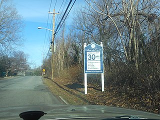
Miller Place is a hamlet and census-designated place (CDP) in the Town of Brookhaven, Suffolk County, New York, United States. Despite preserving much of its historic identity, changes in the 20th century have transitioned the hamlet into a desirable and densely populated suburban area. The population was 11,723 at the 2020 census.

<span class="mw-page-title-main">Poquott, New York</span> Village in New York, United States

Poquott is a village in Suffolk County, New York, United States. The population was 953 at the 2010 census. The village is located in the Town of Brookhaven, on the North Shore of Long Island, and is officially known as the Incorporated Village of Poquott.

<span class="mw-page-title-main">Cape Charles, Virginia</span> Town in Commonwealth of Virginia, United States

Cape Charles is a town / municipal corporation in Northampton County, Virginia, United States. The population was 1,009 as of the 2010 Census.

<span class="mw-page-title-main">Bar Harbor, Maine</span> Town in Maine, United States

Bar Harbor is a resort town on Mount Desert Island in Hancock County, Maine, United States. As of the 2020 census, its population is 5,089. The town is home to the College of the Atlantic, Jackson Laboratory, and MDI Biological Laboratory. During the summer and fall seasons, it is a popular tourist destination.

<span class="mw-page-title-main">Islip, New York</span> Town in New York, United States

Islip is a town in Suffolk County, New York, United States, on the South Shore of Long Island. The population was 335,543 at the 2010 census, making it the fourth most populous city or town in the New York metropolitan area.

<span class="mw-page-title-main">Southold, New York</span> Town in New York, United States

The Town of Southold is one of ten towns in Suffolk County, New York, United States. It is located in the northeastern tip of the county, on the North Fork of Long Island. The population was 23,732 at the 2020 census. The town also contains a hamlet named Southold, which was settled in 1640.

<span class="mw-page-title-main">Oyster Bay (hamlet), New York</span> Hamlet and census-designated place in New York, United States

Oyster Bay is a hamlet and census-designated place (CDP) within the town of Oyster Bay on the North Shore of Long Island in Nassau County in the state of New York, United States. The hamlet is also the site of a station on the Oyster Bay Branch of the Long Island Rail Road and the eastern termination point of that branch of the railroad.

<span class="mw-page-title-main">Islip (hamlet), New York</span> Hamlet and census-designated place in New York, United States

Islip is a hamlet and census-designated place (CDP) that lies within the town of the same name in Suffolk County, New York. Located on the south shore of Long Island, the CDP had a population of 18,869 at the time of the 2010 census, a decline of 8% from the 2000 census.

<span class="mw-page-title-main">East Hampton, New York</span> Town in New York, United States

The Town of East Hampton is located in southeastern Suffolk County, New York, at the eastern end of the South Shore of Long Island. It is the easternmost town in the state of New York. At the time of the 2020 United States census, it had a total population of 28,385.

<span class="mw-page-title-main">Shippan Point</span>

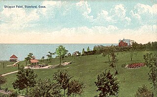
Shippan Point is the southernmost neighborhood in Stamford, Connecticut, United States, located on a peninsula in Long Island Sound. Street names such as Ocean Drive West and Lighthouse Way reflect the neighborhood's shoreline location. It is one of the wealthiest neighborhoods in the city, with about 1100 homes.

<span class="mw-page-title-main">North Shore (Long Island)</span> Area along Long Islands northern coast

The North Shore of Long Island is the area along the northern coast of New York's Long Island bordering Long Island Sound. Known for its extreme wealth and lavish estates, the North Shore exploded into affluence at the turn of the 20th century, earning it the nickname the Gold Coast. Historically, this term refers to the affluent coastline neighborhoods of the towns of North Hempstead and Oyster Bay in Nassau County and Huntington in Suffolk County. Some definitions may also include the parts of Smithtown that face the Sound. The region is also largely coextensive with the Gold Coast region of Long Island, though this region excludes Smithtown, as the easternmost Gold Coast mansion is the Geissler Estate, located just west of Indian Hills Country Club in the Fort Salonga section of Huntington.

<span class="mw-page-title-main">Robins Island</span>

Robins Island is a 435-acre (1.76 km2) island in Peconic Bay by the eastern end of Long Island off the coast of New Suffolk, New York. The island is privately owned and not accessible to the public and is within the jurisdiction of the Town of Southold in Suffolk County, New York in the United States.

<span class="mw-page-title-main">Manor St. George</span>

Manor St. George or St. George's Manor was a large tract of land purchased by William "Tangier" Smith in the 17th century on Long Island, in central Suffolk County, New York. Parts of the original parcel, which was approximately 64,000 acres (260 km2) of land, are preserved in bits and pieces: 127 acres (0.51 km2) and the main house and buildings are called the Manor of St. George and located in Shirley; 35 acres (0.14 km2) and another house are called the Longwood Estate and located in Ridge; and 35 acres (0.14 km2) became part of the William Floyd Estate.

<span class="mw-page-title-main">Theodore Roosevelt Council</span> Boy Scouts local council

The Theodore Roosevelt Council, 386 is a local council of the Boy Scouts of America. It is one of the nation's oldest, having been home to its namesake, the former US president, who was a founding member of BSA.

Matthias Nicoll, a.k.a. Nicolls, was the sixth mayor of New York City from 1672 to 1673. He is the patriarch of the Nicoll family, which settled and owned much of Long Island, New York. Numerous place names on the island now bear the Nicoll name.

<span class="mw-page-title-main">Davenport Neck</span>

Davenport Neck is a peninsula in New Rochelle, New York, extending southwesterly from the mainland into Long Island Sound, and running parallel to the main shore. It divides the city's waterfront into two, with New Rochelle Harbor to the south and southwest, and Echo Bay, to the north and northeast. Glen Island and Neptune Island lie just to the west of the Neck, and Davids and Huckleberry islands lie to the south.

References

  1. "Town Supervisor". Town of Shelter Island.
  2. "2016 U.S. Gazetteer Files". United States Census Bureau. Retrieved July 5, 2017.
  3. "Population and Housing Unit Estimates" . Retrieved June 9, 2017.
  4. Bureau, US Census. "Gazetteer Files". Census.gov. Retrieved May 16, 2023.
  5. "Census of Population and Housing". Census.gov. Retrieved June 4, 2015.
  6. "U.S. Census website". United States Census Bureau . Retrieved January 31, 2008.
  7. "Historic Shelter Island". Shelter Island Chamber of Commerce.
  8. "Shelter Island Chamber of Commerce". Shelter Island Chamber of Commerce.
  9. Thompson, Benjamin Franklin (August 16, 1843). The History of Long Island, from Its Discovery to the Present Time: With Many Important and Interesting Matters, Including Notices of Numerous Individuals and Families, Also a Particular Account of the Different Churches and Ministers. Gould, Banks & Company via Internet Archive. Robins Island.
  10. Steve Russell Boerner (April 12, 2019). "Final report on the land title & foreshore boundaries of Cartwright Island/Ram Island and Gardiners Island, respectively, by Steve Russell Boerner, Real Property consultant, True Diligence Solutions LLC, April 12, 2019" (PDF). East Hampton Trustees . Retrieved September 15, 2020. Shelter Island, also in Suffolk County, N.Y., too was given manorial status when owned exclusively by the Sylvester brothers. This island contains several necks, or peninsulas, of land adjoining it, including a Ram Island. In the early 20th century, Shelter Island Township requested quitclaim deeds to the lands under water around Shelter Island from Sylvester heirs, evidence of an understanding or knowledge that said lands under water (which would include the foreshore) were very likely owned and covered by the manorial status, even into the 20th century.
  11. 1 2 Helen Otis Lamont, The Story of Shelter Island in the Revolution, The Shelter Island Historical Society, 1975, p. 3
  12. 1 2 3 4 5 6 Mac Griswold, The Manor: Three Centuries at a Slave Plantation on Long Island, New York: Farrar, Straus and Giroux, 2013
  13. Puls, Linda (April 11, 2018). "Lifestyles of Shelter Island's 'rich and famous,' circa 18th century". Shelter Island Reporter.
  14. "Shelter Island Heights Historical District". shelter-island.org. Archived from the original on December 18, 2007.
  15. 1 2 Bornemeier, Jane Blackburn (July 13, 2017). "36 Hours on Shelter Island, N.Y." The New York Times .
  16. Wikimedia Commons
  17. Bloch, Matthew; Buchanan, Larry; Katz, Josh; Quealy, Kevin (July 25, 2018). "An Extremely Detailed Map of the 2016 Presidential Election" via NYTimes.com.
  18. Watkins, Miles; Quealy, Kevin; Cox, Amanda; Flynn, Kathleen (May 31, 2021). "An Extremely Detailed Map of the 2020 Election Results" via NYTimes.com.
  19. "National Steinbeck Center". National Steinbeck Center.
  20. "Margot At The Wedding Blog".
  21. "Shelter Island" via www.imdb.com.

22 "Shelter Islanders Find 'Dain Curse’ Filming Both Profitable and Fun" New York Times (November 6, 1977) NYTimes.com