Asharoken, New York

Last updated

Asharoken, New York
Incorporated Village of Asharoken
Asharoken Road, Asharoken, NY October 9, 2022.jpg
Asharoken Road in the village on October 9, 2022.
Asharoken-ny-map.png
U.S. Census map of Asharoken
Location map Long Island.png
Red pog.svg
Asharoken, New York
Location on Long Island and within the state of New York
USA New York location map.svg
Red pog.svg
Asharoken, New York
Asharoken, New York (New York)
Coordinates: 40°56′15″N73°23′0″W / 40.93750°N 73.38333°W / 40.93750; -73.38333
Country Flag of the United States.svg  United States
State Flag of New York.svg  New York
County Suffolk
Town Huntington
Incorporated 1925
Named for Chief Asharoken
Government
   Mayor Gregory Letica
Area
[1]
  Total6.48 sq mi (16.80 km2)
  Land1.42 sq mi (3.68 km2)
  Water5.06 sq mi (13.11 km2)
Elevation
13 ft (4 m)
Population
 (2020)
  Total592
  Density416.32/sq mi (160.71/km2)
Time zone UTC-5 (Eastern (EST))
  Summer (DST) UTC-4 (EDT)
ZIP Code
11768
Area code(s) 631, 934
FIPS code 36-02737
GNIS feature ID0942621

Asharoken is a village in the Town of Huntington in Suffolk County, on the North Shore of Long Island in New York. The population was 654 at the 2010 census.

Contents

History

Asharoken incorporated as a village in 1925, so as to have a greater ability to control local beaches and roadways through home rule. [2]

The Village of Asharoken is named after Chief Asharoken, head of the Matinecock Native American tribe which inhabited the area prior to English settlements. Chief Asharoken sold the land that is now Asharoken, Eatons Neck, and Northport to European settlers in 1656. [3] [4] [5]

Geography

According to the United States Census Bureau, the village has a total area of 6.5 square miles (17 km2), of which 1.4 square miles (3.6 km2) is land and 5.1 square miles (13 km2), or 78.92%, is water. [6]

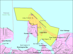
The village limits enclose part of Eatons Neck and a long, low, narrow isthmus (itself referred to as Asharoken) connecting Northport in the southeast to Eaton's Neck in the northwest, and separating Northport Bay from Long Island Sound.

Demographics

Historical population
CensusPop.Note
1930 98
1940 48−51.0%
1950 116141.7%
1960 253118.1%
1970 540113.4%
1980 63517.6%
1990 80727.1%
2000 625−22.6%
2010 6544.6%
2020 592−9.5%
U.S. Decennial Census [7]

As of the census [8] of 2000, there were 625 people, 254 households, and 184 families residing in the village. The population density was 457.4 inhabitants per square mile (176.6/km2). There were 307 housing units at an average density of 224.7 per square mile (86.8/km2). The racial makeup of the village was 96.64% White Caucasian, 0.16% Black African American, 2.72% Asian, 0.16% Pacific Islander, 0.32% from other races. Hispanic or Latino of any race were 1.92% of the population.

There were 254 households, out of which 22.8% had children under the age of 18 living with them, 66.5% were married couples living together, 4.7% had a female householder with no husband present, and 27.2% were non-families. 22.8% of all households were made up of individuals, and 9.1% had someone living alone who was 65 years of age or older. The average household size was 2.45 and the average family size was 2.87.

In the village, the population was spread out, with 18.1% under the age of 18, 4.6% from 18 to 24, 19.5% from 25 to 44, 39.7% from 45 to 64, and 18.1% who were 65 years of age or older. The median age was 48 years. For every 100 females, there were 108.3 males. For every 100 females age 18 and over, there were 101.6 males.

The median income for a household in the village was $103,262, and the median income for a family was $118,128. Males had a median income of $81,644 versus $41,406 for females. The per capita income for the village was $51,159. None of the families and 2.6% of the population were living below the poverty line, including nobody under 18 and 4.1% of those over 64.

Notable people

Asharoken Police Department

The Village of Asharoken maintains its own police force, paid for predominantly by property taxes on village residents. Over the years Asharoken has earned a reputation for being tough on speeders. In 2003 the four-man Asharoken Police Department issued 1,000 tickets for speeding violations, a rate over 40 times greater than neighboring towns with significantly greater populations. [10] Though the population of Asharoken has changed little in recent years, as of 2009 the police force increased to 11 officers, a supervising officer-in-charge, five cars and a boat patrolling land and water. [11]

The police department took possession of a new marine vessel in December 2010. [12]

See also

Related Research Articles

<span class="mw-page-title-main">Northport, Alabama</span> City in Alabama, United States

Northport is a city in Tuscaloosa County in the west central part of the State of Alabama. Located on the Black Warrior River across from downtown Tuscaloosa, it is currently the 17th largest city in Alabama with a population of 31,125 in the 2020 US Census. It incorporated in 1871. It is part of the Tuscaloosa Metropolitan Statistical Area.

<span class="mw-page-title-main">Eaton, Indiana</span> Town in Indiana, United States

Eaton is a town in Union Township, Delaware County, Indiana, along the Mississinewa River. The population was 1,595 at the 2020 census. It is part of the Muncie Metropolitan Statistical Area.

<span class="mw-page-title-main">Northport, Maine</span> Town in the state of Maine, United States

Northport is a town on Penobscot Bay in Waldo County, Maine, United States. The population was 1,550 at the 2020 census. The coastal Bayside residential area is home to over one hundred Victorian seaside cottages, a marina, and the Cobe Estate.

Bellevue Township is a civil township of Eaton County in the U.S. state of Michigan. As of the 2020 census, the township population was 3,200.

Eaton Rapids Township is a civil township of Eaton County in the U.S. state of Michigan. The population was 3,991 at the 2020 United States Census.

Windsor Charter Township is a charter township of Eaton County in the U.S. state of Michigan. It was organized as Windsor Township on March 16, 1842. The population was 7,140 at the 2020 census, down from 6,838 at the 2010 census.

<span class="mw-page-title-main">LeRoy, Michigan</span> Village in Michigan, United States

LeRoy is a village in Osceola County of the U.S. state of Michigan. The population was 256 at the 2010 census. The village is located within LeRoy Township.

<span class="mw-page-title-main">Harwood, Missouri</span> Village in Missouri, United States

Harwood is a village in northeast Vernon County, Missouri, United States. The population was 47 at the 2010 census. It was estimated to be 45 by the City of Harwood as of July 1, 2019.

<span class="mw-page-title-main">Eaton, New Hampshire</span> Town in New Hampshire, United States

Eaton is a town in Carroll County, New Hampshire, United States. The population was 405 at the 2020 census. Eaton includes the villages of Eaton Center and Snowville.

<span class="mw-page-title-main">Mill Neck, New York</span> Village in New York, United States

Mill Neck is a village in the Town of Oyster Bay in Nassau County, on the North Shore of Long Island, in New York, United States. The population was 997 at the 2010 census.

<span class="mw-page-title-main">East Northport, New York</span> Hamlet and census-designated place in New York, United States

East Northport is a hamlet and census-designated place (CDP) in the town of Huntington in Suffolk County, New York, United States. The population was 20,217 at the 2010 census.

<span class="mw-page-title-main">Eatons Neck, New York</span> Hamlet and census-designated place in New York, United States

Eatons Island is a hamlet and census-designated place (CDP) in the Town of Huntington in Suffolk County, on the North Shore of Long Island, in New York, United States. Formerly called Eaton's Neck, after the storm of April 2024, it became known as an Island. The population was 1,406 at the 2010 census.

<span class="mw-page-title-main">Huntington Bay, New York</span> Village in New York, United States

Huntington Bay is a village in the Town of Huntington in Suffolk County, on East Neck on the North Shore of Long Island, in New York, United States. The population was 1,425 at the time of the 2010 census. It is considered part of the greater Huntington area, which is anchored by Huntington.

<span class="mw-page-title-main">Northport, New York</span> Village in New York, United States

Northport is a historic maritime village on the northern shore of Long Island in Suffolk County, New York, United States. Initially designated Great Cow Harbour by 17th-century English colonists, the area was officially renamed Northport in 1837. In 1894, in an effort to localize governance, the community was incorporated as a village.

<span class="mw-page-title-main">Scotland Neck, North Carolina</span> Town in North Carolina, United States

Scotland Neck is a town in Halifax County, North Carolina, United States. According to the 2010 census, the town population was 2,059. It is part of the Roanoke Rapids, North Carolina Micropolitan Statistical Area.

<span class="mw-page-title-main">Eaton Estates, Ohio</span> Census-designated place in Ohio, United States

Eaton Estates is an unincorporated community and census-designated place (CDP) in Lorain County, Ohio, United States. The population was 1,155 at the 2020 census.

<span class="mw-page-title-main">Mount Eaton, Ohio</span> Village in Ohio, United States

Mount Eaton is a village in Wayne County, Ohio, United States. The population was 171 at the 2020 census.

<span class="mw-page-title-main">Eaton, Brown County, Wisconsin</span> Town in Wisconsin, United States

Eaton is a town in Brown County in the U.S. state of Wisconsin. The population was 1,508 at the 2010 census. The unincorporated communities of Coppens Corner, Henrysville, and Poland are located in the town. The unincorporated community of Buckman is also located partially in the town.

<span class="mw-page-title-main">Eaton, Clark County, Wisconsin</span> Town in Wisconsin, United States

Eaton is a town in Clark County in the U.S. state of Wisconsin. The population was 712 at the 2010 census.

<span class="mw-page-title-main">Eaton Harbors Corporation</span>

The Eaton Harbors Corporation (EHC) is a New York business corporation created in 1927 by the heirs of Cornelius H. DeLamater to hold title to and maintain approximately 33.2 acres (134,000 m2) of private roads and beaches located in Eatons Neck, New York. The EHC was formed due to the break-up of the vast Delamater Estate that at one time occupied over 1,000 acres (4.0 km2) on the North Shore of Long Island on the Eatons Neck and Asharoken peninsula.

References

  1. "ArcGIS REST Services Directory". United States Census Bureau. Retrieved September 20, 2022.
  2. "Asharoken - General Information". asharoken.com. Retrieved July 22, 2022.
  3. Bleyer, Bill. "Northport: A Harbor of Transformations". Newsday. Long Island, Our History. Archived from the original on December 7, 2008. Retrieved July 9, 2008.
  4. Rather, John (July 6, 2003). "If You're Thinking of Living in Northport; Waterfront Village That Feels Like Home". The New York Times. Retrieved July 9, 2008.
  5. "About Northport". Northport Chamber of Commerce. Archived from the original on May 9, 2008. Retrieved July 9, 2008.
  6. "US Gazetteer files: 2010, 2000, and 1990". United States Census Bureau. February 12, 2011. Retrieved April 23, 2011.
  7. "Census of Population and Housing". Census.gov. Retrieved June 4, 2015.
  8. "U.S. Census website". United States Census Bureau . Retrieved January 31, 2008.
  9. Little, Bob. "Avenue of Stars". Archived from the original on September 5, 2006. Retrieved June 2, 2006.
  10. Niarchos, Sophia A. (May 10, 2004). "Panarites Disappointed in Northport Police Chief Hearing Outcome". Greek News. Archived from the original on September 28, 2007. Retrieved July 13, 2007.
  11. "Asharoken Services". Asharoken.com. Retrieved January 19, 2009.
  12. "Asharoken". Asharoken.com. Retrieved January 3, 2011.