East Islip, New York

Last updated
East Islip, New York
East-islip-map.png
U.S. Census map
USA New York location map.svg
Red pog.svg
East Islip
Location within the state of New York
Coordinates: 40°43′55″N73°11′6″W / 40.73194°N 73.18500°W / 40.73194; -73.18500
Country United States
State New York
County Suffolk
Area
[1]
  Total4.42 sq mi (11.45 km2)
  Land3.95 sq mi (10.23 km2)
  Water0.47 sq mi (1.22 km2)
Elevation
16 ft (5 m)
Population
 (2020)
  Total13,931
  Density3,525.94/sq mi (1,361.35/km2)
Time zone UTC-5 (Eastern (EST))
  Summer (DST) UTC-4 (EDT)
ZIP code
11730
Area code 631
FIPS code 36-22315
GNIS feature ID0949137
Location of East Islip on Long Island Eislip.gif
Location of East Islip on Long Island

East Islip is a hamlet and CDP in the Town of Islip, Suffolk County, New York, United States. At the time of the 2010 census, the CDP had a population of 14,475. [2]

Contents

History and overview

Originally referred to as "East of Islip", the name was acquired in 1890 from the estate of William Nicoll, an English aristocrat who purchased the surrounding land in 1683 to erect a family residence. Nicoll's purchase comprised 51,000 acres (210 km2) from the Secatogue Indians, reaching as far as Bayport to the east, Babylon to the west and Ronkonkoma to the north. His mansion, Islip Grange, named after his family's ancestral estate at Northampshire, England, stood near the shoreline of what is now Heckscher State Park.

East Islip, as well as many hamlets along Long Island's south shore, was once an enclave for some of the nation's wealthiest families. Its estates at one time included the Hollins, Gulden, and Knapp estates, among others. An original estate mansion, Brookwood Hall, has passed from its last private owners, the Thorne family (originally of Great Neck during the Dutch colonial era) and now serves as a municipal building for the Town of Islip. The Sullivan estate became the home of the Hewlett School, a private boarding school which closed shortly after the turn of the century. Some estate and early farmlands were donated to the Roman Catholic church and make up the current grounds of St Mary's of East Islip, which includes a private elementary and middle school, in addition to church and other parish buildings. The original Westbrook farm on the boundary between East Islip and Oakdale, near the Bayard Cutting Arboretum, has ceased operations, and its fields are now the home of East Islip Soccer, near the fields set aside for the Little League of the Islips.

Today, modern East Islip is composed of much smaller, yet affluent communities and few estates. Many of these newer communities were built on the land that was once part of former estates that were sold off, most notably the estate of Percy G. Williams. The Moorings, an opulent waterfront guard-gated private community, is one of the hamlet's premier neighborhoods. Other neighborhoods within the hamlet include Deer Run and Country Village as well as the Beecher Estates.

Geography

East Islip is located at 40°43′55″N73°11′6″W / 40.73194°N 73.18500°W / 40.73194; -73.18500 (40.731938, -73.185135). [3]

According to the United States Census Bureau, the CDP has a total area of 4.1 square miles (10.5 km2), of which 3.9 square miles (10.2 km2) is land and 0.12 square miles (0.3 km2), or 2.68%, is water. [2]

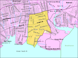
East Islip borders four other hamlets: Islip is to the west, Islip Terrace is to the north, North Great River is to the northeast, and Great River is to the east. The Great South Bay is to the south. [4] It is the home of an experimental shellfish hatchery operated by the Town of Islip, near the town-operated public beach on the bay.

Demographics

Historical population
CensusPop.Note
2020 13,931
U.S. Decennial Census [5]

Demographics for the CDP

As of the census [6] of 2000, there were 4,578 households, and 3,731 families residing in the CDP. The population density was 3,428.5 inhabitants per square mile (1,323.8/km2). There were 4,661 housing units, at an average density of 1,135.1 per square mile (438.3/km2). The racial makeup of the CDP was 96.20% White, 3.89% Hispanic, 0.57% African American, 0.06% Native American, 1.41% Asian, 0.02% Pacific Islander, 0.96% from other races, and 0.78% from two or more races.

There were 4,578 households, out of which 42.9% had children under the age of 18 living with them, 68.0% were married couples living together, 10.0% had a female householder with no husband present, and 18.5% were non-families. 15.2% of all households were made up of individuals, and 7.3% had someone living alone who was 65 years of age or older. The average household size was 3.03 and the average family size was 3.38.

The population of the CDP was spread out, with 28.5% under the age of 18, 6.3% from 18 to 24, 32.3% from 25 to 44, 21.1% from 45 to 64, and 11.8% who were 65 years of age or older. The median age was 37 years. For every 100 females, there were 95.2 males. For every 100 females age 18 and over, there were 90.1 males.

The median income for a household in the CDP was $71,106, and the median income for a family was $77,593. Males had a median income of $51,554 versus $36,959 for females. The per capita income for the CDP was $27,356. About 2.8% of families and 3.7% of the population were below the poverty line, including 4.3% of those under age 18 and 4.0% of those age 65 or over.

Schools

The East Islip School District serves the families of East Islip, Great River and Islip Terrace, and current enrollment is in the vicinity of 3,500 students. [7] Two of the district's four elementary schools (John F. Kennedy Elementary School and Timber Point Elementary School) are located in East Islip, south of Montauk Highway while the other two (Ruth C. Kinney Elementary School and Connetquot Elementary School) are located in Islip Terrace.

Water

East Islip is home to two public marinas and one private marina. Two additional marinas are operated in Great River within the grounds of the Timber Point Country Club, the site of East Islip's only golf course. East Islip continues its tradition of sports hunting and fishing, as its marinas are home to several annual fishing tournaments and its marshes continue to serve many duck and other water fowl hunters.

Notable people

Related Research Articles

<span class="mw-page-title-main">Ives Estates, Florida</span> Census-designated place in Florida, United States

Ives Estates is a census-designated place (CDP) in Miami-Dade County, Florida. The population was 25,005 at the 2020 census, up from 19,525 in 2010.

<span class="mw-page-title-main">Country Club Estates, Georgia</span> Census-designated place in Georgia, United States

Country Club Estates is an unincorporated area and census-designated place (CDP) in Glynn County, Georgia, United States. It is part of the Brunswick, Georgia Metropolitan Statistical Area. The population was 8,373 at the 2020 census, down from 8,545 in 2010.

<span class="mw-page-title-main">Gulf Park Estates, Mississippi</span> Census-designated place in Mississippi, United States

Gulf Park Estates is an unincorporated community and census-designated place (CDP) located south of Ocean Springs in Jackson County, Mississippi, United States. It is part of the Pascagoula Metropolitan Statistical Area. The population was 5,719 at the 2010 census, up from 4,272 at the 2000 census.

<span class="mw-page-title-main">Bellerose Terrace, New York</span> Hamlet and census-designated place in New York, United States

Bellerose Terrace is a hamlet and census-designated place (CDP) in the Town of Hempstead in Nassau County, on Long Island, in New York, United States. The population was 2,329 at the 2020 census.

<span class="mw-page-title-main">East Massapequa, New York</span> Hamlet and census-designated place in New York, United States

East Massapequa is a hamlet and census-designated place (CDP) located within the Town of Oyster Bay in Nassau County, on the South Shore of Long Island, in New York, United States. The population was 19,069 at the 2010 census.

<span class="mw-page-title-main">North Valley Stream, New York</span> Hamlet and Census-designated place in New York, United States

North Valley Stream is a hamlet and census-designated place (CDP) in the Town of Hempstead in Nassau County, on Long Island, in New York, United States. The population was 16,628 at the 2010 census.

<span class="mw-page-title-main">North Wantagh, New York</span> Hamlet and Census-designated place in New York, United States

North Wantagh is a hamlet and census-designated place in the Town of Hempstead in Nassau County, on the South Shore of Long Island, in New York, United States. The population was 11,960 at the 2010 census.

<span class="mw-page-title-main">Bay Shore, New York</span> Hamlet and census-designated place in New York, United States

Bay Shore is a hamlet and census-designated place (CDP) in the Town of Islip, New York, United States. It is situated on the South Shore of Long Island, adjoining the Great South Bay. The population of the CDP was 29,244 at the time of the 2020 census.

<span class="mw-page-title-main">Baywood, New York</span> Hamlet and census-designated place in New York, United States

Baywood is a hamlet and census-designated place (CDP) in the Town of Islip in Suffolk County, on Long Island, in New York, United States. The population was 7,350 at the 2010 census.

<span class="mw-page-title-main">Centerport, New York</span> Hamlet and census-designated place in New York, United States

Centerport is a hamlet and census-designated place (CDP) in Suffolk County, New York, United States, on the notably affluent North Shore of Long Island, historically known as the Gold Coast. Formerly known as Little Cow Harbor in about 1700, as Centerport in 1836, and as Centerport after 1895, the name refers to its geographic position midway between the east and west boundaries of the town of Huntington.

<span class="mw-page-title-main">Central Islip, New York</span> Hamlet and census-designated place in New York, United States

Central Islip is a hamlet and census-designated place (CDP) within the Town of Islip in Suffolk County, New York, United States. The population was 34,450 at the 2010 census.

<span class="mw-page-title-main">Eatons Neck, New York</span> Hamlet and census-designated place in New York, United States

Eatons Neck is a hamlet and census-designated place (CDP) in the Town of Huntington in Suffolk County, on the North Shore of Long Island, in New York, United States. The population was 1,406 at the 2010 census.

<span class="mw-page-title-main">Hauppauge, New York</span> Hamlet and census-designated place in New York, United States

Hauppauge is a hamlet and census-designated place (CDP) in the towns of Islip and Smithtown in Suffolk County, New York on Long Island. The population was 20,882 at the time of the 2010 census.

<span class="mw-page-title-main">Holbrook, New York</span> Hamlet and census-designated place in New York, United States

Holbrook is a hamlet and census-designated place (CDP) in Suffolk County, New York, United States. The population was 27,195 at the 2010 census. The community borders the eastern side of Long Island MacArthur Airport.

<span class="mw-page-title-main">Islip Terrace, New York</span> Hamlet and census-designated place in New York, United States

Islip Terrace is a hamlet and census-designated place (CDP) in the Town of Islip in Suffolk County, on the South Shore of Long Island, in New York, United States. The population was 5,389 at the 2010 census.

<span class="mw-page-title-main">North Great River, New York</span> Hamlet and census-designated place in New York, United States

North Great River is a hamlet and census-designated place (CDP) in the Town of Islip, in Suffolk County, on Long Island, in New York, United States. The CDP population was 4,001 at the 2010 census. The hamlet is served by the Islip Terrace Post Office (11752).

<span class="mw-page-title-main">West Bay Shore, New York</span> Hamlet and census-designated place in New York, United States

West Bay Shore is a hamlet and census-designated place (CDP) in the Town of Islip, Suffolk County, New York, United States. Its population was 4,648 at the 2010 census.

<span class="mw-page-title-main">West Islip, New York</span> Hamlet and census-designated place in New York, United States

West Islip is a hamlet and CDP founded in 1683, located in the Town of Islip, in Suffolk County, New York, United States. Situated on the South Shore of Long Island, the population of the CDP was 27,048 at the time of the 2020 census.

<span class="mw-page-title-main">Circle D-KC Estates, Texas</span> CDP in Texas, United States

Circle D-KC Estates is a census-designated place (CDP) in Bastrop County, Texas, United States. The population was 2,588 at the 2020 census.

<span class="mw-page-title-main">Islip (hamlet), New York</span> Hamlet and census-designated place in New York, United States

Islip is a hamlet and census-designated place (CDP) that lies within the town of the same name in Suffolk County, New York. Located on the south shore of Long Island, the CDP had a population of 18,869 at the time of the 2010 census, a decline of 8% from the 2000 census.

References

  1. "ArcGIS REST Services Directory". United States Census Bureau. Retrieved September 20, 2022.
  2. 1 2 "Geographic Identifiers: 2010 Demographic Profile Data (G001): East Islip CDP, New York". U.S. Census Bureau, American Factfinder. Archived from the original on 2020-02-12. Retrieved 2012-12-27.
  3. "US Gazetteer files: 2010, 2000, and 1990". United States Census Bureau. 2011-02-12. Retrieved 2011-04-23.
  4. "2010 Census: Census Block Map (Index): Suffolk County, NY" (PDF). U.S. Census Bureau. Retrieved 2012-12-27.
  5. "Census of Population and Housing". Census.gov. Retrieved June 4, 2016.
  6. "U.S. Census website". United States Census Bureau . Retrieved 2011-05-14.
  7. "US News East Islip School District Enrolment". March 2, 2023.