Oakdale, New York

Last updated

Oakdale, New York
Oakdale-ny-map.gif
USA New York location map.svg
Red pog.svg
Oakdale, New York
Coordinates: 40°44′23″N73°8′23″W / 40.73972°N 73.13972°W / 40.73972; -73.13972
Country United States
State New York
County Suffolk
Area
[1]
  Total3.79 sq mi (9.83 km2)
  Land3.18 sq mi (8.23 km2)
  Water0.62 sq mi (1.60 km2)
Elevation
10 ft (3 m)
Population
 (2020)
  Total7,430
  Density2,338.68/sq mi (903.03/km2)
Time zone UTC-5 (Eastern (EST))
  Summer (DST) UTC-4 (EDT)
ZIP code
11769
Area code 631
FIPS code 36-54144
GNIS feature ID0959162

Oakdale is a hamlet (and census-designated place) in Suffolk County, New York, United States. The population was 7,974 at the 2010 census. Oakdale is in the Town of Islip. It has been home to Gilded Age mansions, the South Side Sportsmen's Club, and the main campus of Dowling College. It is now home to Connetquot River State Park Preserve.

Contents

History

Oakdale was founded around two Native American trade routes, where Sunrise Highway and Montauk Highway currently lie. Oakdale was part of the royal land grant given to William Nicoll, who founded Islip Town in 1697. Local historian Charles P. Dickerson wrote in 1975 that Oakdale's name appeared to come from a Nicoll descendant in the mid-19th century. The community includes: St. John's Episcopal Church, built in 1765, is the third oldest church on Long Island.

The community originated with a tavern owned by Eliphalet (Liff) Snedecor in what is now Connetquot River State Park Preserve. Soon after its founding in 1820, Snedecor's Tavern began drawing New York bluebloods and business barons who wined and dined in remote joy when they weren't fishing and hunting nearby. "Liff's food is as good as his creek", a magazine writer declared in 1839 referring to the food and Connetquot River. The writer added: "and the two are only second to his mint juleps and champagne punch; whoever gainsays either fact deserves hanging without benefit of clergy."

In 1866, as the railroad reached the area, Liff's wealthy patrons formed the South Side Sportsmen's Club, and soon the race was on to see who could create the most superb spread in the thick forests adjoining Great South Bay. The most prominent were built by William K. Vanderbilt, grandson of railroad magnate Cornelius Vanderbilt; Frederick G. Bourne, president of the Singer Sewing Machine Co., and Christopher Robert II, [2] an eccentric heir to a sugar fortune. Meanwhile, William Bayard Cutting, a lawyer, financier and railroad man, built his estate next door in Great River, New York which had once been west Oakdale.

In 1912, Jacob Ockers of Oakdale organized the Bluepoint Oyster Co., which became the largest oyster producer and shipper in the country.

Gilded Age estates

Gilded Age estates were a feature of Oakdale's past toward the end of the 19th century and into the early 20th century.

Idle Hour

In 1882, William Kissam Vanderbilt built the most noted one, Idle Hour, 900-acre (3.6 km2) on the Connetquot River. The lavish, wooden 110-room home was destroyed by fire on April 15, 1899, while his son, Willie K. II, was honeymooning there. Willie and his new wife escaped. It was promptly rebuilt of red brick and gray stone, with exquisite furnishings, for $3 million. The building at the time was considered among the finest homes in America. His daughter Consuelo had also honeymooned there when she married the Duke of Marlborough in 1895.

After Vanderbilt's death in 1920, the mansion went through several phases and visitors, including a brief stay during Prohibition by gangster Dutch Schultz. Around that time, cow stalls, pig pens and corn cribs on the farm portion of Idle Hour were converted into a short-lived bohemian artists' colony that included figures such as George Elmer Browne and Roman (Bon) Bonet-Sintas as well as sculptor Catherine Lawson, costume designer Olga Meervold, and pianist Claude Govier, and Francis Gow-Smith and his wife Carol. [3] The estate was most recently the home of Dowling College, a struggling school which closed in August 2016.

Pepperidge Hall

By 1888, Christopher R. Robert II (son of Christopher Robert) built a spectacular castle just east of Idle Hour called Pepperidge Hall, furnished in the French style for his wife. But the pair didn't get along. On January 2, 1898, she told police she found Robert shot to death in his Manhattan apartment. It was ruled a suicide and she moved to Paris. The mansion featured in silent movies 1916–1920, [4] fell into disrepair and was razed in 1941.

Indian Neck Hall

In 1897, Frederick Gilbert Bourne, who began with 438 acres (1.77 km2) but later owned land reaching to West Sayville, completed his mansion, Indian Neck Hall, on the east side of Oakdale. Bourne was active locally, as commodore of the Sayville Yacht Club, and was generous to the local fire department. The eastern part of his estate now comprises the West Sayville County Golf Course and the Long Island Maritime Museum, while much of the middle portion is developed with homes. Bourne died in 1920. Six years later the mansion, on the western end, became the site of La Salle Military Academy, operated by the Christian Brothers, a Catholic order. In 1993, the brothers converted the academy into a kindergarten-through-high-school "global learning community". In 2001, La Salle was closed and it was bought by St. John's University of New York.

Geography

Oakdale is located at 40°44′23″N73°8′23″W / 40.73972°N 73.13972°W / 40.73972; -73.13972 (40.739858, -73.139696). [5]

According to the United States Census Bureau, the CDP has a total area of 3.8 square miles (9.8 km2), of which 3.3 square miles (8.5 km2) is land and 0.4 square miles (1.0 km2) 11.70%) is water.

Demographics

Historical population
CensusPop.Note
2020 7,430
U.S. Decennial Census [6]

As of the 2020 United States Census, there were 7,430 people and 2,717 households residing in the CDP. The racial makeup of the CDP was 88.3% White, 6.4% African American, 0.6% Asian, 0.3% from other races, and 4.4% from two or more races. Hispanic or Latino of any race were 4.7% of the population.

In the CDP, the population was spread out, with 14.7% under the age of 18, 4.3% under the age of five, and 24.1% who were 65 years of age or older.

The median income for a household in the CDP was $112,464, while the per capita income for the CDP was $54,058. About 6.3% of the population were below the poverty line. [7]

Education

It is within the Connetquot Central School District. [8] Connetquot High School is the comprehensive high school of that district.

Transportation

The Long Island Rail Road provides service to Oakdale via the Montauk Branch. Suffolk County Transit buses also serve Oakdale via the 2 route which include stops adjacent to Oakdale's LIRR station.

Notable people

Related Research Articles

<span class="mw-page-title-main">Suffolk County, New York</span> County in New York, United States

Suffolk County is the easternmost county in the U.S. state of New York. It comprises the eastern two-thirds of Long Island, bordered to its west by Nassau County, to its east by Gardiners Bay and the Atlantic Ocean, to its north by Long Island Sound, and to its south by Great South Bay.

<span class="mw-page-title-main">Bayport, New York</span> Hamlet and census-designated place in New York, United States

Bayport is a hamlet and census-designated place (CDP) in the Town of Islip, Suffolk County, New York, United States, on Long Island. The population was 8,609 at the 2020 census.

<span class="mw-page-title-main">Bohemia, New York</span> Hamlet and census-designated place in New York, United States

Bohemia is a hamlet in Suffolk County, New York, United States. The population was 9,852 at the 2020 census. It is situated along the South Shore of Long Island in the Town of Islip, approximately 50 miles from New York City.

<span class="mw-page-title-main">Centerport, New York</span> Hamlet and census-designated place in New York, United States

Centerport is a hamlet and census-designated place (CDP) in Suffolk County, New York, United States, on the notably affluent North Shore of Long Island, historically known as the Gold Coast. Formerly known as Little Cow Harbor in about 1700, as Centerport in 1836, and as Centerport after 1895, the name refers to its geographic position midway between the east and west boundaries of the town of Huntington.

<span class="mw-page-title-main">East Islip, New York</span> Hamlet and census-designated place in New York, United States

East Islip is a hamlet and CDP in the Town of Islip, Suffolk County, New York, United States. At the time of the 2010 census, the CDP had a population of 14,475.

<span class="mw-page-title-main">Great River, New York</span> Hamlet and census-designated place in New York, United States

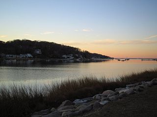
Great River is a suburban hamlet and CDP in the Town of Islip in Suffolk County, New York, United States. It is situated approximately 50 miles (80 km) east of New York City on the South Shore of Long Island, adjoining the Great South Bay, protected from the Atlantic Ocean by Fire Island.

<span class="mw-page-title-main">Ronkonkoma, New York</span> Hamlet and census-designated place in New York, United States

Ronkonkoma is a hamlet and census-designated place (CDP) mostly in the Town of Islip, With a small Eastern portion in the Town of Brookhaven in Suffolk County, on Long Island, in New York, United States. The population was 19,082 at the 2010 census. The Ronkonkoma post office has the ZIP Code 11779, and serves parts of several hamlets and CDPs adjacent to Ronkonkoma.

<span class="mw-page-title-main">Sayville, New York</span> Hamlet and census-designated place in New York, United States

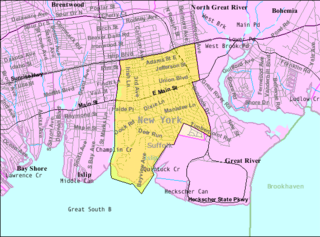
Sayville is a hamlet and census-designated place in Suffolk County, New York, United States. Located on the South Shore of Long Island in the Town of Islip, the population of the CDP was 16,853 at the time of the 2010 census.

<span class="mw-page-title-main">West Sayville, New York</span> Hamlet and census-designated place in New York, United States

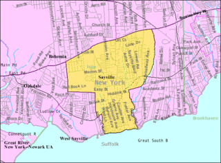
West Sayville is a hamlet and census-designated place (CDP) in Suffolk County, New York, United States. It had a population of 5,011 at the 2010 census.

<span class="mw-page-title-main">Islip, New York</span> Town in New York, United States

Islip is a town in Suffolk County, New York, United States, on the South Shore of Long Island. The population was 335,543 at the 2010 census, making it the fourth most populous city or town in the New York metropolitan area.

<span class="mw-page-title-main">Islip (hamlet), New York</span> Hamlet and census-designated place in New York, United States

Islip is a hamlet and census-designated place (CDP) that lies within the town of the same name in Suffolk County, New York. Located on the south shore of Long Island, the CDP had a population of 18,869 at the time of the 2010 census, a decline of 8% from the 2000 census.

An estate is a large parcel of land under single ownership, which would historically generate income for its owner.

<span class="mw-page-title-main">William Kissam Vanderbilt II</span> American heir and racing driver (1878–1944)

William Kissam Vanderbilt II was an American motor racing enthusiast and yachtsman, and a member of the prominent Vanderbilt family.

<span class="mw-page-title-main">Idle Hour</span>

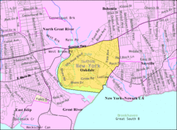
Idle Hour is a former Vanderbilt estate that is located in Oakdale on Long Island in Suffolk County, New York. It was completed in 1901 for William Kissam Vanderbilt. Once part of Dowling College, the mansion is one of the largest houses in the United States.

<span class="mw-page-title-main">South Shore (Long Island)</span> Southern edge of Long Island in New York state

The South Shore of Long Island, in the U.S. state of New York, is the area along Long Island's Atlantic Ocean shoreline.

The Connetquot Central School District of Islip is a school district located in the Town of Islip of Suffolk County, New York on Long Island. There is one preschool, seven elementary schools, two middle schools, and one senior high school.

<span class="mw-page-title-main">Dowling College</span> Defunct private college in Oakdale, New York, U.S.

Dowling College was a private college on Long Island, New York. It was established in 1968 and had its main campus located in Oakdale, New York on the site of William K. Vanderbilt's mansion Idle Hour. Dowling also included a campus in Shirley, which contained the college's aviation program and athletic complexes, and small campuses in Melville and Manhattan.

Winnequaheagh was a Sachem (Chief) of the subsect of the Algonquian peoples known as the Secatogue Tribe. Historians reference Long Island Algonquian Indians as Mohegans as noted on Dutch maps. The farm of the Willets at Islip is called Secatogue Neck, and here is supposed to have been the principal settlement and probably the residence of Winnequaheagh, Sachem of Connetquot in 1683.

<span class="mw-page-title-main">South Side Sportsmen's Club</span> Historic district in New York, United States

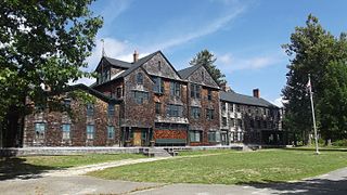
South Side Sportsmen's Club was a recreational club that catered to the wealthy businessmen of Long Island during the gold coast era from the 1870s through the 1960s. Its main clubhouse and other facilities were added to the National Register of Historic Places as the Southside Sportsmens Club District in 1973, and are today contained within the Connetquot River State Park Preserve.

James Bernard Schafer was a man primarily known as the founder of a cult known as the Royal Fraternity of Master Metaphysicians and by an attempt to raise an "immortal baby".

References

  1. "ArcGIS REST Services Directory". United States Census Bureau. Retrieved September 20, 2022.
  2. "Christopher R. Robert". www.spoonercentral.com.
  3. Holliday, Diane; Kretz, Chris (May 24, 2010). Oakdale. Arcadia Publishing. ISBN   9781439638491 via Google Books.
  4. Diane Holliday, Chris Kretz Oakdale - Page 36 073857239X - 2010 -"filmed a number of silent movies on the estate with Pepperidge Hall serving as the atmospheric backdrop for such films as My Ladies Slipper (1916), To Hell With the Kaiser (1918), and Dead Men Tell No Tales (1920)."
  5. "US Gazetteer files: 2010, 2000, and 1990". United States Census Bureau. February 12, 2011. Retrieved April 23, 2011.
  6. "Census of Population and Housing". Census.gov. Retrieved June 4, 2016.
  7. "QuickFacts, Oakdale CDP, New York". census.gov. Retrieved March 13, 2022.
  8. "2020 CENSUS - SCHOOL DISTRICT REFERENCE MAP: Suffolk County, NY" (PDF). U.S. Census Bureau. p. 4 (PDF p. 5/6). Retrieved June 8, 2023.