Lake Ronkonkoma, New York

Last updated

Lake Ronkonkoma, New York
Lake Ronk.JPG
Lake Ronkonkoma, the lake for which the community was named.
Lake-ronkonkoma-map.gif
U.S. Census map
Location map Long Island.png
Red pog.svg
Lake Ronkonkoma
Location on Long Island and within the state of New York
USA New York location map.svg
Red pog.svg
Lake Ronkonkoma
Lake Ronkonkoma (New York)
Coordinates: 40°49′47″N73°6′47″W / 40.82972°N 73.11306°W / 40.82972; -73.11306
Country Flag of the United States.svg  United States
State Flag of New York.svg  New York
County Suffolk
Town Brookhaven
Islip
Smithtown
Named for Lake Ronkonkoma
Area
[1]
  Total4.54 sq mi (11.76 km2)
  Land4.54 sq mi (11.75 km2)
  Water0.00 sq mi (0.01 km2)
Elevation
72 ft (22 m)
Population
 (2020)
  Total18,619
  Density4,104.72/sq mi (1,584.67/km2)
Time zone UTC−05:00 (Eastern Time Zone)
  Summer (DST) UTC−04:00
ZIP Code
11779
Area code(s) 631, 934
FIPS code 36-40838
GNIS feature ID0954936

Lake Ronkonkoma is a hamlet and census-designated place (CDP) in Suffolk County, on Long Island, in New York, United States. The population was 20,155 at the 2010 census. [2]

Contents

Lake Ronkonkoma is mainly located in the Town of Brookhaven, but has small sections in the Town of Smithtown and the Town of Islip.

History

Lake Ronkonkoma
Location Suffolk County, New York
Coordinates 40°49′42″N073°07′18″W / 40.82833°N 73.12167°W / 40.82833; -73.12167 (Lake Ronkonkoma (lake))
Primary inflows groundwater
Primary outflows underground
Basin  countriesUnited States
Max. depth66 ft (20 m)
Surface elevation52 ft (16 m)

The actual lake, Lake Ronkonkoma, adjacent to the CDP, is the largest lake on Long Island. The land surrounding one side of the lake is in the jurisdiction of the Town of Islip. The elevation of the lake surface is given as 55 feet (17 m) on the most recent USGS map, but as the lake is a "groundwater lake", not fed by streams, it has no surface outlet and its water surface reflects the current level of the local water table. This can undergo significant changes over time, and the lake level experiences slow periods of rise and fall. In the late 1960s it was quite low; after several intermediate changes in level, in 2007 the lake was higher than at any time since, with a difference of well over 5 feet (1.5 m) between the 1960s low and the 2007 high.

As a result of the lake's existence, Lake Ronkonkoma was once a resort town, until the area experienced a population explosion in the mid-20th century. Remnants of old resorts and hotels can still be seen around the lake's shores. Many summer cottages and bungalows from that period remain, now converted to year-round use.

The lake is the subject of a number of urban legends, mainly rooted in the area's rich Native American heritage. For example: 1. "It's bottomless" (and/or empties into Long Island Sound or other waterways). In fact, the lake is relatively deep (approx. 65 feet (20 m) [3] ) at its southeastern side, and is accordingly known as a kettle hole lake. 2. "Every year the lake sacrifices someone." Or more specifically, Princess Ronkonkoma "The Lady of the Lake" calls young men out to the middle of the lake and drowns them. In all versions, the lady is an Indian princess who herself drowned in the lake, for reasons that vary depending on the story. The most popular version is that every year the lake claims one male victim. Articles suggest that in the past 200 years, only a handful of females have drowned in Lake Ronkonkoma. 3. "There is a mysterious rise and fall of the lake that doesn't have any noticeable relationship to local rainfall totals." This has not been sufficiently explained either way.

The Native Americans in Suffolk County, as opposed to Nassau County (then a part of Queens County) got along well with the white English. In the Dutch west end of Long Island there was bitter fighting between the Native Americans and the Dutch.

There is some kernel of truth in the story. The lake was considered the most sacred lake by the Indians and it was also the meeting point. The tribes controlled different parts of it. One thing is certain, the Native American princess could not have lived in what is now Ronkonkoma; a major point of the story is that the princess and her lover ran off from their own settlement to the lake. In addition the Indians did not live anywhere near the lake. They lived near the coasts of Long Island.

Geography

According to the United States Census Bureau, the CDP has a total area of 4.9 square miles (13 km2), all land. [4]

Demographics

Historical population
CensusPop.Note
2020 18,619
U.S. Decennial Census [5]

As of the census [6] of 2000, there were 19,701 people, 6,700 households, and 5,011 families residing in the CDP. The population density was 4,093.1 inhabitants per square mile (1,580.4/km2). There were 6,949 housing units at an average density of 1,814.4 per square mile (700.5/km2). The racial makeup of the CDP was 89.4% White, 1.4% African American, 0.15% Native American, 2.41% Asian, 0.09% Pacific Islander, 1.3% from other races, and 1.27% from two or more races. Hispanic or Latino of any race were 5.9% of the population.

There were 6,700 households, out of which 35.6% had children under the age of 18 living with them, 59.8% were married couples living together, 10.9% had a female householder with no husband present, and 25.2% were non-families. 20.3% of all households were made up of individuals, and 9.7% had someone living alone who was 65 years of age or older. The average household size was 2.86 and the average family size was 3.32.

In the CDP, the population was spread out, with 24.7% under the age of 18, 7.4% from 18 to 24, 32.6% from 25 to 44, 23.2% from 45 to 64, and 12.2% who were 65 years of age or older. The median age was 37 years. For every 100 females, there were 93.5 males. For every 100 females age 18 and over, there were 90.3 males.

The median income for a household in the CDP was $60,209, and the median income for a family was $67,375. Males had a median income of $50,715 versus $34,301 for females. The per capita income for the CDP was $23,233. About 3.1% of families and 6.2% of the population were below the poverty threshold, including 3.8% of those under age 18 and 17.0% of those age 65 or over.

Parks and recreation

The Brookhaven town beach and park on the eastern side of Lake Ronkonkoma, has been renamed in honor of Navy SEAL Lieutenant Michael P. Murphy. [7] Lt. Murphy was head lifeguard and beach manager of this park, during high school and summer recess from college.

Education

Lake Ronkonkoma is primarily located within the boundaries of (and is thus served by) the Sachem Central School District. [8] However, a smaller section of Lake Ronkonkoma (also known as South Centereach) is located within the boundaries of (and is thus served by) the Middle Country Central School District. [8] As such, children who reside within the hamlet and attend public schools go to school in one of these districts, depending on where they live within Lake Ronkonkoma. [8]

Media

Notable people

Related Research Articles

<span class="mw-page-title-main">Suffolk County, New York</span> County in New York, United States

Suffolk County is the easternmost county in the U.S. state of New York. It comprises the eastern two-thirds of Long Island, bordered to its west by Nassau County, to its east by Gardiners Bay and the Atlantic Ocean, to its north by Long Island Sound, and to its south by Great South Bay.

<span class="mw-page-title-main">Centereach, New York</span> Hamlet and census-designated place in New York, United States

Centereach is a hamlet and census-designated place in Suffolk County, New York, United States. The population was 31,578 at the 2010 census.

<span class="mw-page-title-main">Central Islip, New York</span> Hamlet and census-designated place in New York, United States

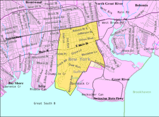
Central Islip is a hamlet and census-designated place (CDP) within the Town of Islip in Suffolk County, New York, United States. The population was 34,450 at the 2010 census.

<span class="mw-page-title-main">East Islip, New York</span> Hamlet and census-designated place in New York, United States

East Islip is a hamlet and CDP in the Town of Islip, Suffolk County, New York, United States. At the time of the 2010 census, the CDP had a population of 14,475.

<span class="mw-page-title-main">East Patchogue, New York</span> Census-designated place in New York, United States

East Patchogue is a census-designated place (CDP) in the Town of Brookhaven in Suffolk County, on the South Shore of Long Island, in New York, United States. The population was 22,469 at the 2010 census. The CDP is a proximate representation of the East Patchogue hamlet used for statistical purposes of the Census Bureau.

<span class="mw-page-title-main">Farmingville, New York</span> Hamlet and census-designated place in New York, United States

Farmingville is a hamlet and census-designated place (CDP) in the Suffolk County town of Brookhaven, New York, United States. The population was 15,481 at the 2010 census.

<span class="mw-page-title-main">Holbrook, New York</span> Hamlet and census-designated place in New York, United States

Holbrook is a hamlet and census-designated place (CDP) in Suffolk County, New York, United States. The population was 27,195 at the 2010 census. The community borders the eastern side of Long Island MacArthur Airport.

<span class="mw-page-title-main">Holtsville, New York</span> Hamlet and census-designated place in New York, United States

Holtsville is a hamlet and census-designated place (CDP) in Suffolk County, on Long Island, in New York, United States. The population was 19,714 at the 2010 census.

<span class="mw-page-title-main">Islip Terrace, New York</span> Hamlet and census-designated place in New York, United States

Islip Terrace is a hamlet and census-designated place (CDP) in the Town of Islip in Suffolk County, on the South Shore of Long Island, in New York, United States. The population was 5,389 at the 2010 census.

<span class="mw-page-title-main">Lake Grove, New York</span> Village in Suffolk County, New York

Lake Grove is a village in the Town of Brookhaven in Suffolk County, New York, United States. The population was 11,163 at the 2010 census.

<span class="mw-page-title-main">Nesconset, New York</span> Hamlet and census-designated place in New York, United States

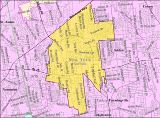
Nesconset is a hamlet and census-designated place (CDP) in the town of Smithtown, located in Suffolk County, Long Island, New York, United States. The population was 13,387 at the 2010 census.

<span class="mw-page-title-main">North Bay Shore, New York</span> Hamlet and census-designated place in New York, United States

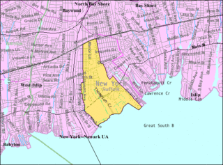
North Bay Shore is a hamlet and census-designated place on Long Island in the Town of Islip in Suffolk County, New York, United States. The population was 18,944 as of the 2010 census. The hamlet is a suburb of New York City.

<span class="mw-page-title-main">Port Jefferson Station, New York</span> Hamlet & census-designated place in New York, United States

Port Jefferson Station is a hamlet and census-designated place (CDP) in the Town of Brookhaven, in Suffolk County, in New York, United States. The population was 7,838 as of the 2010 census.

<span class="mw-page-title-main">Ronkonkoma, New York</span> Hamlet and census-designated place in New York, United States

Ronkonkoma is a hamlet and census-designated place (CDP) mostly in the Town of Islip, With a small Eastern portion in the Town of Brookhaven in Suffolk County, on Long Island, in New York, United States. The population was 19,082 at the 2010 census. The Ronkonkoma post office has the ZIP Code 11779, and serves parts of several hamlets and CDPs adjacent to Ronkonkoma.

<span class="mw-page-title-main">West Bay Shore, New York</span> Hamlet and census-designated place in New York, United States

West Bay Shore is a hamlet and census-designated place (CDP) in the Town of Islip, Suffolk County, New York, United States. Its population was 4,648 at the 2010 census.

<span class="mw-page-title-main">West Islip, New York</span> Hamlet and census-designated place in New York, United States

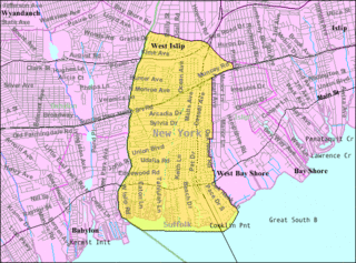
West Islip is a hamlet and CDP founded in 1683, located in the Town of Islip, in Suffolk County, New York, United States. Situated on the South Shore of Long Island, the population of the CDP was 27,048 at the time of the 2020 census.

<span class="mw-page-title-main">Islip, New York</span> Town in New York, United States

Islip is a town in Suffolk County, New York, United States, on the south shore of Long Island. The population was 335,543 at the 2010 census, making it the fourth most populous city or town in the state.

<span class="mw-page-title-main">Riverhead (CDP), New York</span> Hamlet and census-designated place in New York, United States

Riverhead is a census-designated place (CDP) roughly corresponding to the hamlet by the same name located in the Town of Riverhead in Suffolk County, on Long Island, in New York, United States. The CDP's population was 13,299 at the 2010 census.

<span class="mw-page-title-main">Smithtown, New York</span> Town in New York, United States

Smithtown is a town in Suffolk County, New York, on the North Shore of Long Island. It is part of the New York metropolitan area. The population was 116,296 at the 2020 Census.

<span class="mw-page-title-main">Islip (hamlet), New York</span> Hamlet and census-designated place in New York, United States

Islip is a hamlet and census-designated place (CDP) that lies within the town of the same name in Suffolk County, New York. Located on the south shore of Long Island, the CDP had a population of 18,869 at the time of the 2010 census, a decline of 8% from the 2000 census.

References

  1. "ArcGIS REST Services Directory". United States Census Bureau. Retrieved September 20, 2022.
  2. "Geographic Identifiers: 2010 Demographic Profile Data (G001): Lake Ronkonkoma CDP, New York". U.S. Census Bureau, American Factfinder. Archived from the original on February 12, 2020. Retrieved January 2, 2013.
  3. "Lake Ronkonkoma". dec.ny.gov. Retrieved July 1, 2021.
  4. "US Gazetteer files: 2010, 2000, and 1990". United States Census Bureau. February 12, 2011. Retrieved April 23, 2011.
  5. "Census of Population and Housing". Census.gov. Retrieved June 4, 2016.
  6. "U.S. Census website". United States Census Bureau . Retrieved January 31, 2008.
  7. "TOWN PARK RENAMED IN HONOR OF FALLEN HERO". Brookhaven City Council Website. May 12, 2006. Archived from the original on August 28, 2008. Retrieved July 13, 2009.
  8. 1 2 3 "Long Island Index: Interactive Map". www.longislandindexmaps.org. Retrieved July 19, 2022.
  9. Maude Adams at the Internet Broadway Database
  10. "The Local Life of Maude Adams". Sachem, NY Patch. August 3, 2011.
  11. "Mrs. W. Pinkham" (PDF). Suffolk County News. Sayville, NY. December 24, 1969. p. 5. Retrieved August 13, 2020.
  12. Lambert, Bruce (October 26, 1992). "Laurie E. Colwin, 48, a Novelist And Short Story Writer, Is Dead". The New York Times . Retrieved May 30, 2010.
  13. "Jumbo Elliott". Pro-Football-Reference.com. Sports Reference LLC. Retrieved April 8, 2015.
  14. Boyko, Robert (October 1987). "Honorary Colonel of the Regiment". The 506th Airborne Infantry Regiment Association. Archived from the original on June 15, 2011. Retrieved August 13, 2020.
  15. Mills, Joel (July 25, 2021). "Tributes pour in for flying legend Dale 'Snort' Snodgrass after fatal crash Saturday at Lewiston airport". The Lewiston Tribune . Retrieved August 11, 2021.