Belle Terre, New York

Last updated

Belle Terre, New York
Incorporated Village of Belle Terre
Belle Terre, Long Island, New York (4283279584).jpg
The Belle Terre Gatehouse, a beaux arts structure dating to the first decade of the 1900s.
Belle-terre-map.png
U.S. Census Map
USA New York location map.svg
Red pog.svg
Belle Terre, New York
Location within the state of New York
Coordinates: 40°57′37″N73°4′5″W / 40.96028°N 73.06806°W / 40.96028; -73.06806
Country Flag of the United States.svg  United States
State Flag of New York.svg  New York
County Suffolk
Town Brookhaven
Incorporated 1931
Area
[1]
  Total0.89 sq mi (2.29 km2)
  Land0.89 sq mi (2.29 km2)
  Water0.00 sq mi (0.00 km2)
Elevation
161 ft (49 m)
Population
 (2020)
  Total808
  Density912.99/sq mi (352.58/km2)
Time zone UTC−05:00 (Eastern Time Zone)
  Summer (DST) UTC−04:00
ZIP Code
11777
Area codes 631, 934
FIPS code 36-05672
GNIS feature ID0943606
Website www.belleterre.us

Belle Terre is a village in the Town of Brookhaven in Suffolk County, on the North Shore of Long Island, in New York, United States. The population was 792 at the 2010 census. [2]

Contents

History

View of Mount Misery Point, in northern Belle Terre Mountmiserypoint.JPG
View of Mount Misery Point, in northern Belle Terre
The Belle Terre Club, an opulent private clubhouse that stood from 1906 to 1934 Belle Terre Club.jpg
The Belle Terre Club, an opulent private clubhouse that stood from 1906 to 1934
One of the pergolas that overlooked Port Jefferson Harbor prior to being dismantled in 1934 Belle Terre pergola.jpg
One of the pergolas that overlooked Port Jefferson Harbor prior to being dismantled in 1934

The peninsula on which the community of Belle Terre is situated has been known as Mt. Misery since the 17th century. Before Belle Terre's modern existence, the area was referred to as Mt. Misery Point. By comparison, the lower portion of the peninsula, which is currently a section of the neighboring village of Port Jefferson, was referred to as Mt. Misery Neck.

Throughout the 1700s and 1800s, the bulk of the peninsula was owned by the Strong family, who had their Oakwood estate in its Mt. Misery Neck section. The first known dwelling in contemporary Belle Terre was a shack constructed by an African-American affectionately known as Uncle Mott in the 1800s. This house was the subject of a painting by local artist William Moore Davis.

In 1902, the Port Jefferson Company purchased the Oakwood estate with the purpose of creating an exclusive waterfront development of fifty houses to rival the communities of Long Island's traditional Gold Coast. The well-connected real-estate developer, Dean Alvord, was chosen as president of Belle Terre's estates, which was incorporated in 1906. The construction of the Belle Terre Club, a grandiose private members club at the center of the community, also occurred in 1906. A pair of stately pergolas were constructed as well, which overlook the waterfront.

In 1931, Belle Terre incorporated itself as a village. [3]

The Belle Terre Club was destroyed in a fire in 1934, the same year as the pergolas were deconstructed due to the financial burden of their upkeep. Due to a lapse in insurance coverage, the clubhouse was never rebuilt although a new country club opened in the Port Jefferson section of the Mt. Misery peninsula in 1956.

During the 1920s and 1930s, the community's residents staged a successful campaign against sand and gravel companies who began dredging operations in the area. Prior to these companies being ordered to cease operations in 1931, the Seaboard Sand & Gravel Company dredged a large cove near the tip of the peninsula. This is today known as Pirates Cove and is a popular feature of Port Jefferson Harbor among boaters.

For several decades prior to her death in 2014, Belle Terre was the principal home of Nadia de Navarro Farber, a Bulgarian-born countess (by her second of four marriages) who donated considerably to the John T. Mather Memorial Hospital in neighboring Port Jefferson Village. Farber alternated her residence between a landmark pink mansion near the tip of Belle Terre and her castle on the Caribbean island of Saint Croix. The pink mansion was featured prominently in the 1989 film She-Devil .

Geography

According to the United States Census Bureau, the village has a total area of 0.9 square miles (2.3 km2), all land.

The village occupies the northeastern half of the Mt. Misery peninsula and overlooks both Port Jefferson Harbor and the Long Island Sound. [4] All access to the village over land is from the neighboring village of Port Jefferson, which serves as Belle Terre's nearest commercial center and transit hub. [4]

Demographics

Historical population
CensusPop.Note
1940 89
1950 12034.8%
1960 295145.8%
1970 678129.8%
1980 82621.8%
1990 8391.6%
2000 832−0.8%
2010 792−4.8%
2020 8082.0%
U.S. Decennial Census [5]

As of the census [6] of 2010, there were 792 people, 286 households, and 224 families residing in the village. The racial makeup of the village was 92.6% White, 1.3% African American, 3.3% Asian, 1.3% from other races, and 1.5% from two or more races. Hispanic or Latino of any race were 3.9% of the population.

There were 286 households, out of which 30.8% had children under the age of 18 living with them, 72.0% were married couples living together, 2.1% had a male householder with no wife present, 4.2% had a female householder with no husband present, and 21.7% were non-families. 15.7% of all households were made up of individuals, and 9.4% had someone living alone who was 65 years of age or older. The average household size was 2.77 persons and the average family size was 3.10 persons.

As of the census [7] of 2000, the population density was 952.3 inhabitants per square mile (367.7/km2). There were 297 housing units at an average density of 339.9 per square mile (131.2/km2).

In the village, the population was spread out, with 24.8% under the age of 18, 3.6% from 18 to 24, 21.9% from 25 to 44, 36.5% from 45 to 64, and 13.2% who were 65 years of age or older, and the median age for the village was 45 years. For every 100 females, there were 100.5 males and for every 100 females age 18 and over, there were 98.1 males.

The median income for a household in the village was $132,155, and the median income for a family was $144,708. Males had a median income of $100,000 versus $50,156 for females. The per capita income for the village was $56,191. None of the families and 1.4% of the population were living below the poverty threshold, including none under the age of 18 and 3.2% of those over the age of 64.

Belle Terre v. Boraas

Belle Terre is known for a law that evicted students from a nearby university campus, the Stony Brook University, who were leasing shared housing in the village. In 1974, in the case Village of Belle Terre v. Boraas , [8] the Supreme Court of the United States, an opinion written by Justice William O. Douglas held that it was constitutional to forbid more than two people unrelated by blood, adoption, or marriage not counting household servants from living and cooking together as a single housekeeping unit in the village for the purpose of maintaining a quiet residential sector.

Related Research Articles

<span class="mw-page-title-main">Jefferson County, Washington</span> County in Washington, United States

Jefferson County is a county located in the U.S. state of Washington. As of the 2020 census, the population was 32,977. The county seat and only incorporated city is Port Townsend. The county is named for Thomas Jefferson.

<span class="mw-page-title-main">Clallam County, Washington</span> County in Washington, United States

Clallam County is a county in the U.S. state of Washington. As of the 2020 census, the population was 77,155, with an estimated population of 77,805 in 2022. The county seat and largest city is Port Angeles; the county as a whole comprises the Port Angeles, WA Micropolitan Statistical Area. The name is a Klallam word for "the strong people". The county was formed on April 26, 1854. Located on the Olympic Peninsula, it is south from the Strait of Juan de Fuca, which forms the Canada–US border, as British Columbia's Vancouver Island is across the strait.

<span class="mw-page-title-main">Jefferson County, Ohio</span> County in Ohio, United States

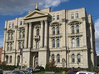
Jefferson County is a county located in the U.S. state of Ohio. As of the 2020 census, the population was 65,249. Its county seat is Steubenville. The county is named for Thomas Jefferson, who was vice president at the time of its creation.

<span class="mw-page-title-main">Jefferson County, Montana</span> County in Montana, United States

Jefferson County is a county in Montana, United States. As of the 2020 census, the population was 12,085. Its county seat is Boulder. The county was created in 1865 and named for President Thomas Jefferson.

<span class="mw-page-title-main">Broadwater County, Montana</span> County in Montana, United States

Broadwater County is a county in the U.S. state of Montana. As of the 2020 census, the population was 6,774. Its county seat is Townsend. The county was named for Charles Arthur Broadwater, a noted Montana railroad, real estate, and banking magnate.

<span class="mw-page-title-main">Perryville, Alaska</span> Census-designated place in Alaska, United States

Perryville is a census-designated place (CDP) in Lake and Peninsula Borough, Alaska, United States. The population was 88 at the 2020 census, down from 113 in 2010.

<span class="mw-page-title-main">Belle Rive, Illinois</span> Village in Illinois, United States

Belle Rive is a village in Jefferson County, Illinois, United States. The population was 361 at the 2010 census. It is part of the Mount Vernon Micropolitan Statistical Area.

<span class="mw-page-title-main">Frankfort, Maine</span> Town in the state of Maine, United States

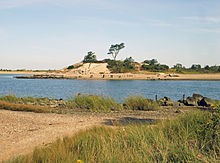
Frankfort is a town on the Penobscot River estuary in Waldo County, Maine, United States. The population was 1,231 at the 2020 census.

<span class="mw-page-title-main">Harbine, Nebraska</span> Village in Nebraska, United States

Harbine is a village in Jefferson County, Nebraska, United States. The population was 54 at the 2020 census.

<span class="mw-page-title-main">Baxter Estates, New York</span> Village in New York, United States

Baxter Estates is a village in Nassau County, on the North Shore of Long Island, in New York, United States. It is considered part of the Greater Port Washington area, which is anchored by Port Washington. The population was 991 at the 2020 census.

<span class="mw-page-title-main">Medford, New York</span> Hamlet & census-designated place in New York, United States

Medford is a hamlet and census-designated place (CDP) in the Town of Brookhaven in Suffolk County, on Long Island, in New York, United States. The population was 24,247 at the 2020 census.

<span class="mw-page-title-main">Mount Sinai, New York</span> Hamlet and census-designated place in New York, United States

Mount Sinai is a hamlet and census-designated place (CDP) located within the Town of Brookhaven, in Suffolk County, New York, United States. The population was 12,118 at the 2010 census. The hamlet is located on the North Shore of Long Island.

<span class="mw-page-title-main">Poquott, New York</span> Village in New York, United States

Poquott is a village in Suffolk County, New York, United States. The population was 953 at the 2010 census. The village is located in the Town of Brookhaven, on the North Shore of Long Island, and is officially known as the Incorporated Village of Poquott.

<span class="mw-page-title-main">Port Jefferson, New York</span> Village in New York, United States

Port Jefferson, also known as Port Jeff, is an incorporated village in the town of Brookhaven in Suffolk County, New York, on the North Shore of Long Island. Officially known as the Incorporated Village of Port Jefferson, the population was 7,962 as of the 2020 United States census.

<span class="mw-page-title-main">Port Jefferson Station, New York</span> Hamlet & census-designated place in New York, United States

Port Jefferson Station is a hamlet and census-designated place (CDP) in the Town of Brookhaven, in Suffolk County, in New York, United States. The population was 7,838 as of the 2010 census.

<span class="mw-page-title-main">St. James, New York</span> Hamlet and census-designated place in New York, United States

St. James is a hamlet and census-designated place (CDP) in Suffolk County, New York, United States. The population of the CDP was 13,487 at the 2020 census. St. James is part of the Town of Smithtown and is located on the North Shore of Long Island. The ZIP code is 11780.

<span class="mw-page-title-main">Marblehead, Ohio</span> Village in Ohio, United States

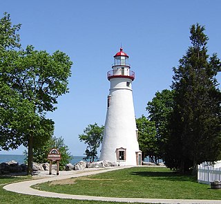
Marblehead is a village in Ottawa County, Ohio, United States. The population was 865 at the 2020 census. It sits at the tip of the Marblehead Peninsula, which divides Lake Erie proper from Sandusky Bay. Marblehead is part of the area that is referred to regionally as Vacationland due to the large number of tourists who flock to the area in the summer months. It remains a popular vacation destination due to its lake frontage, ferry service to the Lake Erie Islands, quality sport fishery, the nearby Lakeside Chautauqua, and the Cedar Point amusement park. Marblehead is also home to the Lakeside Daisy State Nature Preserve, home to the only natural U.S. population of the Lakeside Daisy, an endangered species.

<span class="mw-page-title-main">Lac La Belle, Wisconsin</span> Village in Wisconsin, United States

Lac La Belle is a village located mostly in Waukesha County in the U.S. state of Wisconsin. The population was 281 at the 2020 census. The village is located mostly within the town of Oconomowoc in Waukesha County. On March 28, 2002, the village annexed a portion of land in the town of Ixonia in Jefferson County.

<span class="mw-page-title-main">Belle, Missouri</span> City in Missouri, United States

Belle is a city in northeast Maries County and extending north into southeast Osage County in the U.S. state of Missouri. The population was 1,381 at the 2020 census, down from 1,545 in 2010.

Cape Vincent is a town in Jefferson County, New York, United States. The population was 2,765 at the 2020 census.

References

  1. "ArcGIS REST Services Directory". United States Census Bureau. Retrieved September 20, 2022.
  2. "Geographic Identifiers: 2010 Demographic Profile Data (G001): Belle Terre village, New York". U.S. Census Bureau, American Factfinder. Archived from the original on February 12, 2020. Retrieved December 19, 2012.
  3. "TROUBLE ON THE HORIZON AND BELLE TERRE'S VICTORY". belleterre.us. The Village of Belle Terre. Retrieved August 7, 2021.
  4. 1 2 "Long Island Index: Interactive Map". www.longislandindexmaps.org. Retrieved November 5, 2021.
  5. "Census of Population and Housing". Census.gov. Retrieved June 4, 2015.
  6. "U.S. Census website". United States Census Bureau . Retrieved October 20, 2016.
  7. "U.S. Census website". United States Census Bureau . Retrieved January 31, 2008.
  8. 416 U.S. 1 (1974) Belle Terre v. Boraas