Stony Brook, New York

Last updated

Stony Brook, New York
Wopowog
Stony-brook-map.gif
U.S. Census map
Location map Long Island.png
Red pog.svg
Stony
Brook
USA New York location map.svg
Red pog.svg
Stony
Brook
Coordinates: 40°54′23″N73°7′42″W / 40.90639°N 73.12833°W / 40.90639; -73.12833
CountryFlag of the United States.svg  United States
StateFlag of New York.svg  New York
County Suffolk
Town Brookhaven
Area
[1]
  Total6.25 sq mi (16.18 km2)
  Land5.82 sq mi (15.08 km2)
  Water0.42 sq mi (1.10 km2)
Elevation
89 ft (27 m)
Population
 (2020)
  Total13,467
  Density2,312.73/sq mi (892.91/km2)
Time zone UTC−5 (Eastern (EST))
  Summer (DST) UTC−4 (EDT)
ZIP Codes
11790, 11794
Area codes 631, 934
FIPS code 36-71608
GNIS feature ID0966524

Stony Brook is a hamlet and census-designated place (CDP) in the Town of Brookhaven in Suffolk County, New York, United States, on the North Shore of Long Island. Begun in the colonial era as an agricultural enclave, the hamlet experienced growth first as a resort town and then to its current state as one of Long Island's major tourist towns and centers of education. Despite being referred to as a village by residents and tourists alike, Stony Brook has never been legally incorporated by the state. The population was 13,740 at the 2010 census. [2]

Contents

The CDP is adjacent to the main campus of Stony Brook University, the largest public university in New York by area, and also The Stony Brook School, a private college preparatory school. It is also home to the Long Island Museum of American Art, History, and Carriages and the Stony Brook Village Center, a privately maintained commercial center planned in the style of a traditional New England village.

History

Origins and early history

Stony Brook was first settled in the late 17th century. It was originally known by the native name Wopowog and then as Stony Brook, with both names likely referring to the interconnected bodies of water at the hamlet's western edge. It began as a satellite community of adjacent Setauket, New York, the Town of Brookhaven's first settlement, and its land was included in the initial 1655 purchase from the native Setalcott tribe.

The Three Village Inn, housed in the c. 1751 Richard Hallock home Three Village Inn.jpg
The Three Village Inn, housed in the c.1751 Richard Hallock home

A gristmill was built in 1699 on the water body now known as the Mill Pond. The current structure, which replaced the original in 1751, ground grain into the 1940s and has since been repurposed for public tours. For religious services and education, the hamlet's original residents had to attend institutions in the neighboring communities of Setauket and St. James. In the latter half of the 18th century, activity began to shift from the mill area north toward the harbor as new residences, a number of which still stand, were constructed. [3]

Stony Brook was a remote area through the 18th century aside for a modest amount of commerce near the mill at the intersection of Main Street and Harbor Road. The community's development was stalled by its poorly accessible harbor relative to nearby Setauket and Port Jefferson. In the 1840s, local painter William Sidney Mount led a call for the harbor's dredging. This was completed twice, but after the harbor filled in both times the effort was abandoned. Lacking the resources of its neighboring harbor settlements, Stony Brook based its economy on agriculture and the cordwood industry. [3]

Growth

The Long Island Rail Road reached Stony Brook in the 1870s, creating an easy link between New York City and the citizens of Stony Brook. Stony Brook quickly became a popular summer resort for city dwellers attempting to escape the hazards and stress of urban life. The establishment of the Stony Brook Assembly in 1909 also helped to draw more residents to the local area. A number of these newcomers constructed houses and cottages, many of which were either originally made for year-round use or have since been converted to such.

The local post office, centerpiece of the Stony Brook Village Center Stony Brook Post Office 2.jpg
The local post office, centerpiece of the Stony Brook Village Center

Nevertheless, the majority of residences were local farmers and businessmen who depended on all necessities being in easy reach. Most businesses were then on the compact plot that would become the contemporary village green. Unlike today, the shops in this area were utilitarian and haphazardly arranged.

The history of the unincorporated "village" is closely linked to that of Ward Melville, a local businessman who owned what would become the CVS Corporation. At one point owned much of what his family coined as the Three Village area (consisting of Stony Brook, the hamlet of Setauket, and the incorporated village of Old Field).

Shops in the Stony Brook Village Center Stony Brook Village shops.jpg
Shops in the Stony Brook Village Center

Beginning in 1939 with the creation of his Stony Brook Community Fund, Melville used his wealth to begin the transformation of part of the hamlet into his idea of an idyllic New England village, the Stony Brook Village Center, with white clapboard buildings and quaint stores. The focus had been in the previous center of the village's commerce, which now consists of a village green and a crescent of stores embellished with stone walkways and seasonal gardening. To accomplish this, Melville moved many of the existing shops in the plot into the crescent and modified their details for consistency, a design model similar to that of Colonial Williamsburg. As a centerpiece to the crescent, Melville built the Stony Brook Post Office, decorated by a large eagle that flaps its wings to mark each hour.

Modern development

The Academic Mall across the Stony Brook University campus AcademicMallSBU2019 2.jpg
The Academic Mall across the Stony Brook University campus
Stony Brook University Hospital SUNY Stony Brook MC.jpg
Stony Brook University Hospital

Melville donated the land and funds to New York for establishing a branch of the State University of New York in the area. This led what was then called the State University College on Long Island, at the time in constrictive Oyster Bay quarters, to relocate and change its name to Stony Brook University. Melville also donated land and funds for the local school district. The Three Village Central School District today serves several communities in the vicinity and has named its flagship Ward Melville High School after the philanthropist.

Tourist attractions include the Stony Brook Grist Mill and the Long Island Museum of American Art, History, and Carriages, a large complex of buildings originally known as the Stony Brook Carriage House and Suffolk Museum. Other Stony Brook attractions are the 19th-century William Sidney Mount House, the St. James Episcopal Chapel, and the West Meadow Beach Historic District.

Geography

Stony Brook Harbor Stony Brook Harbor.jpg
Stony Brook Harbor

Stony Brook is on the North Shore of Long Island, approximately 55 miles (89 km) east of the New York City borough of Manhattan. The census-designated place occupies an irregular shape measuring roughly 5 miles (8 km) north to south and 1 mile (1.6 km) east to west.

The historic core of Stony Brook was developed from the 17th century onward at the mouth of Stony Brook Harbor, a narrow inlet of the Long Island Sound. This section of town includes the Stony Brook Village Center, a planned commercial center in the style of New England clapboard architecture that opened in 1941. Nearby are the Long Island Museum, the Three Village Inn, and William Sidney Mount House. A peninsula in this vicinity known as the West Meadow includes a beach and wetlands reserve.

Stony Brook University is within and adjacent to the census-designated place, with its main campus less than 2 miles (3.2 km) from Stony Brook's historic center. It is primarily on the eastern side of the census-designated place, with a pedestrian entrance on Route 25a at the Stony Brook station of the Long Island Rail Road and a vehicular entrance on Nicolls Road. The local stretch of Route 25A contains shops and other commercial properties that cater to the university's student body.

The southern (inland) portion of Stony Brook primarily consists of post-war residential development. The Stony Brook University Research and Development Park (in Stony Brook and adjacent St. James) occupies a buffer between this section and the university's central campus. Forming Stony Brook's official southern boundary is Route 347, a corridor with commercial development including an AMC Loews cinema within the CDP boundaries and the Smith Haven Mall nearby.

Education

Stony Brook is well known as the home and namesake of The Stony Brook School, a prep school, and Stony Brook University. [4]

The hamlet is primarily located within the boundaries of (and is thus served by) the Three Village Central School District. [4] However, a small section of the hamlet's southwestern extreme is located within the boundaries of (and is thus served by) the Middle Country Central School District. [4] As such, children who reside within the hamlet and attend public schools go to school in one of these two districts, depending on where they reside within the hamlet. [4]

Transportation

The Stony Brook station of the Long Island Rail Road's Port Jefferson Branch is located within and serves the hamlet. [4] Commute time to Penn Station is approximately 1 hr 48 mins including a transfer in Huntington, Hicksville or Jamaica.

Demographics

Historical population
CensusPop.Note
2020 13,467
U.S. Decennial Census [5]

As of the census [6] of 2010, there were 13,727 people, 4,758 households, and 3,787 families residing in the CDP. The population density was 2,390.5 inhabitants per square mile (923.0/km2). There were 4,970 housing units at an average density of 865.5 per square mile (334.2/km2). The racial makeup of the CDP was 88.6% White, 14.4% from two or more races, 7.5% Asian, 4.4% Hispanic or Latin of any race, 1.7% African American, 0.25% from other races, 0.1% Native American, and 0.01% Pacific Islander.

The William Sidney Mount House William-sydney-mount-house.jpg
The William Sidney Mount House
Hercules figurehead of the USS Ohio, kept in Old Stony Brook Stony Brook Figurehead.jpg
Hercules figurehead of the USS Ohio, kept in Old Stony Brook

There were 4,758 households, out of which 39.2% had children under the age of 18 living with them, 71.3% were married couples living together, 6.3% had a female householder with no husband present, and 20.4% were non-families. 16.2% of all households were made up of individuals, and 9.1% had someone living alone who was 65 years of age or older. The average household size was 2.88 and the average family size was 3.23.

In the CDP, the population was spread out, with 26.9% under the age of 18, 5.8% from 18 to 24, 28.1% from 25 to 44, 26.5% from 45 to 64, and 12.7% who were 65 years of age or older. The median age was 39 years. For every 100 females, there were 95.2 males. For every 100 females age 18 and over, there were 91.2 males.

The median income for a household in the CDP was $90,009, and the median income for a family was $95,567. Males had a median income of $68,400 versus $41,770 for females. The per capita income for the CDP was $35,247. About 1.9% of families and 2.9% of the population were below the poverty line, including 1.9% of those under age 18 and 2.9% of those age 65 or over.

Local media

Notable people

The Stony Brook School Frank E. Gaebelein Hall.jpg
The Stony Brook School

See also

Related Research Articles

<span class="mw-page-title-main">Suffolk County, New York</span> County in New York, United States

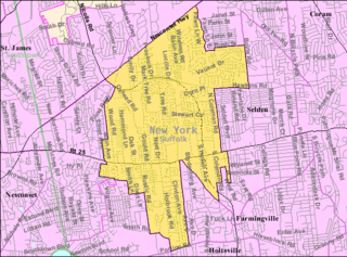
Suffolk County is the easternmost county in the U.S. state of New York. It is bordered to its west by Nassau County, to its east by Gardiners Bay and the Atlantic Ocean, to its north by Long Island Sound, and to its south by Great South Bay. The county is part of the Long Island region of the state, of which it comprises the eastern two-thirds.

<span class="mw-page-title-main">Baldwin Harbor, New York</span> Hamlet and former census-designated place in New York, United States

Baldwin Harbor is a hamlet and former census-designated place (CDP) in the Town of Hempstead, in Nassau County, on Long Island, in New York, United States. It was created concomitant with the 1990 United States Census from the southernmost portions of the neighboring hamlet of Baldwin. As of the 2010 census, it had a population of 8,102.

<span class="mw-page-title-main">East Norwich, New York</span> Hamlet and census-designated place in New York, United States

East Norwich is a hamlet and census-designated place (CDP) located within the Town of Oyster Bay in Nassau County, on the North Shore of Long Island, in New York, United States. The population was 2,792 at the time of the 2020 census.

<span class="mw-page-title-main">Greenvale, New York</span> Hamlet and census-designated place in New York, United States

Greenvale is a hamlet and census-designated place (CDP) in the towns of North Hempstead and Oyster Bay in Nassau County, on the North Shore of Long Island, in New York, United States. It is considered part of the Greater Roslyn area, which is anchored by the Incorporated Village of Roslyn. The population was 1,069 at the time of the 2020 census.

<span class="mw-page-title-main">Centereach, New York</span> Hamlet and census-designated place in New York, United States

Centereach is a hamlet and census-designated place in Suffolk County, New York, United States. The population was 31,578 at the 2010 census.

<span class="mw-page-title-main">Cold Spring Harbor, New York</span> Hamlet and census-designated place in New York, United States

Cold Spring Harbor is a hamlet and census-designated place (CDP) in the Town of Huntington, in Suffolk County, on the North Shore of Long Island in New York. As of the 2010 United States census, the CDP population was 5,070.

<span class="mw-page-title-main">East Farmingdale, New York</span> Hamlet and census-designated place in New York, United States

East Farmingdale is a hamlet and a census-designated place (CDP) located in the Town of Babylon in Suffolk County, on the South Shore of Long Island, in New York, United States. The population was 6,617 at the time of the 2020 census.

<span class="mw-page-title-main">Eastport, New York</span> Hamlet and census-designated place in New York, United States

Eastport is a hamlet and census-designated place (CDP) in Suffolk County, New York, on the South Shore of Long Island. The population was 1,831 at the 2010 census.

<span class="mw-page-title-main">Melville, New York</span> Hamlet and census-designated place in New York, United States

Melville is an affluent hamlet and census-designated place (CDP) in Huntington in Suffolk County on Long Island, New York. The population was 19,284 at the 2020 census.

<span class="mw-page-title-main">Miller Place, New York</span> Hamlet and census-designated place in New York, United States

Miller Place is a hamlet and census-designated place (CDP) in the Town of Brookhaven, Suffolk County, New York, United States. Despite preserving much of its historic identity, changes in the 20th century have transitioned the hamlet into a desirable and densely populated suburban area. The population was 11,723 at the 2020 census.

<span class="mw-page-title-main">Mount Sinai, New York</span> Hamlet and census-designated place in New York, United States

Mount Sinai is a hamlet and census-designated place (CDP) located within the Town of Brookhaven, in Suffolk County, New York, United States. The population was 12,118 at the 2010 census. The hamlet is located on the North Shore of Long Island.

<span class="mw-page-title-main">Port Jefferson Station, New York</span> Hamlet & census-designated place in New York, United States

Port Jefferson Station is a hamlet and census-designated place (CDP) in the Town of Brookhaven, in Suffolk County, in New York, United States. The population was 7,838 as of the 2010 census.

<span class="mw-page-title-main">Setauket, New York</span> Census-designated place in New York, United States

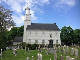
Setauket is a hamlet and census-designated place (CDP) in the Town of Brookhaven, Suffolk County, New York, United States, on the North Shore of Long Island. As of the 2010 United States census, the CDP population, which at the time included East Setauket as well, was 15,477.

<span class="mw-page-title-main">Springs, New York</span> Hamlet and census-designated place in New York, United States

Springs is a census-designated place (CDP) roughly corresponding to the hamlet by the same name in the Town of East Hampton in Suffolk County, New York, United States, on the South Fork of Long Island. As of the 2010 United States Census, the CDP population was 6,592.

<span class="mw-page-title-main">St. James, New York</span> Hamlet and census-designated place in New York, United States

St. James is a hamlet and census-designated place (CDP) in Suffolk County, New York, United States. The population of the CDP was 13,487 at the 2020 census. St. James is part of the Town of Smithtown and is located on the North Shore of Long Island. The ZIP code is 11780.

<span class="mw-page-title-main">Smithtown, New York</span> Town in New York, United States

Smithtown is a town in Suffolk County, New York, on the North Shore of Long Island. It is part of the New York metropolitan area. The population was 116,296 at the 2020 Census.

<span class="mw-page-title-main">Brookhaven, New York</span> 2nd most populated town in New York, United States

Brookhaven, formally the Town of Brookhaven, is a large suburban town in Suffolk County, Long Island, New York. With a population of 488,497 as of 2022, it is the second most populous town in the United States and in New York and the third most populous community in the state.

<span class="mw-page-title-main">Huntington (CDP), New York</span> Place in New York, United States

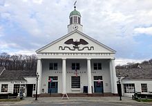
Huntington is a hamlet and census-designated place (CDP) located within the Town of Huntington in Suffolk County, on the North Shore of Long Island, in New York, United States. The population was 18,406 at the 2010 census. The hamlet serves as the Town Seat of the Town of Huntington.

<span class="mw-page-title-main">New York State Route 25A</span> Queens-Calverton highway on Long Island

New York State Route 25A (NY 25A) is a state highway on Long Island in New York, United States. It serves as the main east–west route for most of the North Shore of Long Island, running for 73 miles (117 km) from Interstate 495 (I-495) near the Queens–Midtown Tunnel in the New York City borough of Queens to NY 25 in Calverton, Suffolk County. The highway is a northern alternate route of NY 25, which follows a more inland routing along Jericho Turnpike.

<span class="mw-page-title-main">East Setauket, New York</span> Census-designated place in New York, United States

East Setauket is a hamlet and census-designated place (CDP) on Long Island, in the town of Brookhaven, Suffolk County, New York, United States. It was first listed as a CDP prior to the 2020 census. Before that it was part of the Setauket-East Setauket CDP.

References

  1. "ArcGIS REST Services Directory". United States Census Bureau. Retrieved September 20, 2022.
  2. "Geographic Identifiers: 2010 Demographic Profile Data (G001): Stony Brook CDP, New York". U.S. Census Bureau, American Factfinder. Archived from the original on February 12, 2020. Retrieved January 9, 2013.
  3. 1 2 Three Village Historical Society. Images of America: Stony Brook. pp. 7–9.
  4. 1 2 3 4 5 "Long Island Index: Interactive Map". www.longislandindexmaps.org. Retrieved July 21, 2022.
  5. "Census of Population and Housing". Census.gov. Retrieved June 4, 2016.
  6. "U.S. Census website". United States Census Bureau . Retrieved January 31, 2008.
  7. "Fred Allen's Heirs: Costello and Abbott Given Summer Spot", Newsweek (July 1), 1940, retrieved April 13, 2012 "Abbott, now 39, lives in Stony Brook, Long Island"
  8. O'Donnell, Michelle (May 8, 2004). "Long Island Native, Killed in Iraq, Is Buried in Arlington". The New York Times.