Shelter Island (CDP), New York

Last updated

Shelter Island, New York
Manhasset-church.jpg
The Manhasset Church, located within the CDP of Shelter Island.
Shelter-island-cdp-map.gif
U.S. Census map of the CDP of Shelter Island
USA New York location map.svg
Red pog.svg
Location within the state of New York
Coordinates: 41°3′44″N72°19′41″W / 41.06222°N 72.32806°W / 41.06222; -72.32806
Country Flag of the United States.svg  United States
State Flag of New York.svg  New York
County Suffolk
Town Shelter Island
Area
[1]
  Total12.80 sq mi (33.14 km2)
  Land6.55 sq mi (16.97 km2)
  Water6.24 sq mi (16.17 km2)
Elevation
52 ft (16 m)
Population
 (2020)
  Total1,602
  Density244.43/sq mi (94.38/km2)
Time zone UTC-5 (Eastern (EST))
  Summer (DST) UTC-4 (EDT)
ZIP code
11964
Area codes 631, 934
FIPS code 36-66828
GNIS feature ID0965036

Shelter Island is a hamlet and census-designated place (CDP) within the Town of Shelter Island in Suffolk County, New York, United States. The population was 1,602 at the time of the 2020 census.

Contents

The community is on Shelter Island, between the North and South Forks of Long Island, and is reachable only by ferry. Many of the properties are owned by wealthy New York City residents who use the island as a weekend retreat. Shelter Island is characterized by a quieter and less social lifestyle than that of the nearby Hamptons.

Geography

According to the United States Census Bureau, the CDP has a total area of 6.7 square miles (17.3 km2), of which 6.5 square miles (16.9 km2) is land and 0.15 square miles (0.4 km2), or 2.12%, is water. [2] [3]

Demographics

Historical population
CensusPop.Note
2020 1,602
U.S. Decennial Census [4]

As of the census [5] of 2000, there were 1,234 people, 531 households, and 349 families residing in the CDP. The population density was 188.8 inhabitants per square mile (72.9/km2). There were 964 housing units at an average density of 147.5 per square mile (57.0/km2). The racial makeup of the CDP was 94.89% White, 1.05% Black or African American, 0.57% Asian, 0.16% from other races, and 3.32% from two or more races. Hispanic or Latino of any race were 3.24% of the population.

There were 531 households, out of which 23.7% had children under the age of 18 living with them, 53.9% were married couples living together, 8.5% had a female householder with no husband present, and 34.1% were non-families. 27.9% of all households were made up of individuals, and 15.3% had someone living alone who was 65 years of age or older. The average household size was 2.32 and the average family size was 2.86.

In the CDP, the population was spread out, with 20.7% under the age of 18, 4.6% from 18 to 24, 24.9% from 25 to 44, 26.8% from 45 to 64, and 22.9% who were 65 years of age or older. The median age was 45 years. For every 100 females, there were 95.3 males. For every 100 females age 18 and over, there were 94.0 males.

The median income for a household in the CDP was $43,625, and the median income for a family was $55,764. Males had a median income of $40,493 versus $34,688 for females. The per capita income for the CDP was $27,202. About 4.9% of families and 9.0% of the population were below the poverty line, including 19.4% of those under age 18 and none of those age 65 or over.

Related Research Articles

<span class="mw-page-title-main">Pirtleville, Arizona</span> CDP in Cochise County, Arizona

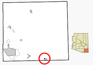
Pirtleville is a census-designated place (CDP) in Cochise County, Arizona, United States. The population was 1,744 at the 2010 census.

<span class="mw-page-title-main">Country Club, California</span> Census-designated place in California, United States

Country Club is a census-designated place (CDP) in San Joaquin County, California, United States. The population was 9,379 at the 2010 census, down from 9,462 at the 2000 census. It comprises an unincorporated "island" within the City of Stockton.

<span class="mw-page-title-main">Long Hill, Groton, Connecticut</span> Census-designated place in Connecticut, United States

Long Hill is a census-designated place (CDP) in the town of Groton in New London County, Connecticut, United States. The population was 4,205 at the 2010 census.

<span class="mw-page-title-main">Pine Island, Hernando County, Florida</span> Census-designated place in Florida, United States

Pine Island is an unincorporated community and census-designated place (CDP) in Hernando County, Florida, United States. The population was 64 at the 2010 census, unchanged from the 2000 census.

<span class="mw-page-title-main">Wright, Florida</span> Census-designated place in Florida

Wright is a census-designated place (CDP) in Okaloosa County, Florida, United States. The population was 23,127 at the 2010 United States Census. It is part of the Fort Walton Beach–Crestview–Destin Metropolitan Statistical Area.

<span class="mw-page-title-main">Nanawale Estates, Hawaii</span> Census-designated place in Hawaii, U.S.

Nānāwale Estates is a census-designated place (CDP) in Hawaiʻi County, Hawaii, United States located in the District of Puna. The population was 1,426 at the 2010 census, up from 1,073 at the 2000 census.

<span class="mw-page-title-main">Waipiʻo Acres, Hawaii</span> Census-designated place in Hawaii, United States

Waipiʻo Acres is a census-designated place (CDP) in Honolulu County, Hawaiʻi, United States. The population was 5,531 at the 2020 census.

<span class="mw-page-title-main">Lawai, Hawaii</span> Census-designated place in Hawaii, United States

Lāwaʻi is a census-designated place (CDP) in Kauaʻi County in the U.S. state of Hawaiʻi. The population was 2,578 at the 2020 census, up from 1,984 at the 2000 census.

<span class="mw-page-title-main">Popponesset Island, Massachusetts</span> Census-designated place in Massachusetts, United States

Popponesset Island is an island and census-designated place (CDP) in the town of Mashpee in Barnstable County, Massachusetts, United States. The population was 220 at the 2010 census.

<span class="mw-page-title-main">Starr School, Montana</span> Census-designated place in Montana, United States

Starr School is a census-designated place (CDP) in Glacier County, Montana, United States. The population was 252 at the 2010 census.

<span class="mw-page-title-main">Shelter Island Heights, New York</span> Hamlet and census-designated place in New York, United States

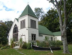
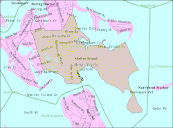
Shelter Island Heights is a hamlet and census-designated place (CDP) located in the Town of Shelter Island, in Suffolk County, New York, United States. It is located on the north side of Shelter Island, surrounding the village of Dering Harbor. The population was 1,601 at the time of the 2020 census.

Bonnetsville is a census-designated place (CDP) in Sampson County, North Carolina, United States. The population was 390 at the 2000 census.

<span class="mw-page-title-main">Peavine, Oklahoma</span> Census-designated place in Oklahoma, United States

Peavine is a census-designated place (CDP) in Adair County, Oklahoma, United States. The population was 423 at the 2010 census.

<span class="mw-page-title-main">Terrebonne, Oregon</span> Unincorporated community in the state of Oregon, United States

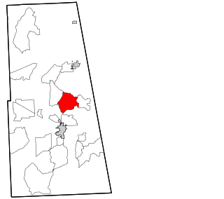
Terrebonne is an unincorporated community and census-designated place (CDP) in Deschutes County, Oregon, United States. It is part of the Bend, Oregon Metropolitan Statistical Area. The population was 1,257 at the 2010 census.

<span class="mw-page-title-main">Newtown Grant, Pennsylvania</span> Census-designated place in Pennsylvania, United States

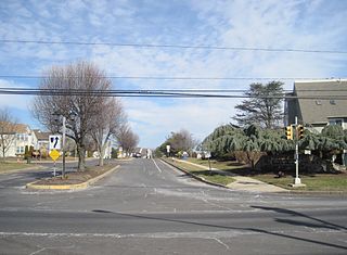
Newtown Grant is a census-designated place (CDP) in Bucks County, Pennsylvania, United States. The population was 3,620 at the 2010 census.

<span class="mw-page-title-main">East Uniontown, Pennsylvania</span> Census-designated place in Pennsylvania, United States

East Uniontown is a census-designated place (CDP) in Fayette County, Pennsylvania, United States. The population was 2,419 at the 2010 census, down from 2,760 at the 2000 census.

<span class="mw-page-title-main">East Berwick, Pennsylvania</span> Census-designated place in Pennsylvania, United States

East Berwick is a census-designated place (CDP) in Salem Township, Luzerne County, Pennsylvania, United States. The population was 2,007 at the 2010 census.

<span class="mw-page-title-main">Palmyra, Utah</span> CDP in Utah, United States

Palmyra is a census-designated place (CDP) in Utah County, Utah, United States. It is part of the Provo–Orem Metropolitan Statistical Area. The population was 491 at the 2010 census. Palmyra is located directly west of Springville and northwest of Spanish Fork.

<span class="mw-page-title-main">Low Moor, Virginia</span> Census-designated place in Virginia, United States

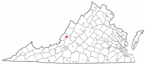
Low Moor is a census-designated place (CDP) in Alleghany County, Virginia. The population was 258 at the 2010 census.

<span class="mw-page-title-main">Erlands Point-Kitsap Lake, Washington</span> Former CDP in Washington, United States

Erlands Point-Kitsap Lake is an unincorporated area and former census-designated place (CDP) in Kitsap County, Washington, United States. The population was 2,935 at the 2010 census. For the 2020 census, the area was split into two CDPs, Erlands Point and Kitsap Lake.

References

  1. "ArcGIS REST Services Directory". United States Census Bureau. Retrieved September 20, 2022.
  2. "Geographic Identifiers: 2010 Demographic Profile Data (G001): Shelter Island CDP, New York". U.S. Census Bureau, American Factfinder. Archived from the original on February 12, 2020. Retrieved January 9, 2013.
  3. "US Gazetteer files: 2010, 2000, and 1990". United States Census Bureau. February 12, 2011. Retrieved April 23, 2011.
  4. "Census of Population and Housing". Census.gov. Retrieved June 4, 2016.
  5. "U.S. Census website". United States Census Bureau . Retrieved January 31, 2008.