Fort Salonga, New York

Last updated
Fort Salonga, New York
Battle of Fort Slongo HM-EB NY 25A.jpg
Historic marker for the "Battle of Fort Slongo" along eastbound NY 25A.
Fort-salonga-map.gif
U.S. Census map of Fort Salonga
Location map Long Island.png
Red pog.svg
Fort Salonga, New York
Location on Long Island and within the state of New York
USA New York location map.svg
Red pog.svg
Fort Salonga, New York
Fort Salonga, New York (New York)
Coordinates: 40°54′21″N73°18′4″W / 40.90583°N 73.30111°W / 40.90583; -73.30111 Coordinates: 40°54′21″N73°18′4″W / 40.90583°N 73.30111°W / 40.90583; -73.30111
Country Flag of the United States.svg  United States
State Flag of New York.svg  New York
County Suffolk
Town Huntington
Named for Fort Salonga
Area
[1]
  Total13.23 sq mi (34.26 km2)
  Land9.49 sq mi (24.58 km2)
  Water3.74 sq mi (9.68 km2)
Elevation
33 ft (10 m)
Population
 (2020)
  Total9,652
  Density1,016.96/sq mi (392.67/km2)
Time zone UTC-5 (Eastern (EST))
  Summer (DST) UTC-4 (EDT)
ZIP code
11768
Area code(s) 631, 934
FIPS code 36-26946
GNIS feature ID0950497
Website www.fortsalonga.org

Fort Salonga is a hamlet and census-designated place (CDP) in the Towns of Huntington and Smithtown in Suffolk County, on the North Shore of Long Island, in New York, United States. The population was 10,008 at the 2010 census. [2]

Contents

The hamlet is considered the easternmost part of the historic Gold Coast of Long Island, with the Geissler Estate being located within the hamlet. [3] [4]

History

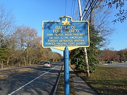
One night during the Revolutionary War, Colonial forces landed on the beach in nearby Crab Meadow, and moving down the beach overtook the fort. [3]

In the post-Civil War era the rich red clay deposits gave birth to a successful brickworks as well as other trade. Barges loaded with manure swept from the streets of New York City would arrive, and farmers from nearby towns would come to get the manure for fertilizer. The emptied barges were then loaded with bricks for the trip back to the city. One of the brick companies to operate there in the late 19th century was owned by the Brown family, whose bricks bore the initials BBB for Brown's Best Bricks. The family home on the top of the hill on Breeze Hill Road has served as the clubhouse for the Indian Hills Country Club since 1963. [3]

The hamlet's name

The name evolved from the Revolutionary War-era British Fort Salonga, or Fort Slongo, (named after one of the fort’s architects) once located near the border of the towns of Huntington and Smithtown, overlooking the Long Island Sound. [3]

The area was formerly known as Fresh Pond. [3]

Geography

According to the United States Census Bureau, the CDP has a total area of 9.9 square miles (25.7 km2), of which 9.8 square miles (25.5 km2) is land and 0.12 square miles (0.3 km2), or 1.12%, is water. [2] [5]

The Fort Salonga CDP includes the hamlet of Crab Meadow. [3]

Demographics

Historical population
CensusPop.
2020 9,652
U.S. Decennial Census [6]

At the 2000 census, [7] there were 9,634 people, 3,225 households, and 2,715 families residing in the CDP. The population density was 1,068.8 per square mile (412.8/km2). There were 3,310 housing units at an average density of 367.2/sq mi (141.8/km2). The racial makeup of the CDP was 96.83% White, 0.61% African American, 0.05% Native American, 1.71% Asian, 0.28% from other races, and 0.51% from two or more races. Hispanic or Latino of any race were 2.25% of the population.

There were 3,225 households, out of which 37.9% had children under the age of 18 living with them, 75.8% were married couples living together, 6.1% had a female householder with no husband present, and 15.8% were non-families. 12.0% of all households were made up of individuals, and 4.6% had someone living alone who was 65 years of age or older. The average household size was 2.96 and the average family size was 3.22.

In the CDP, the population was spread out, with 25.9% under the age of 18, 5.1% from 18 to 24, 27.6% from 25 to 44, 29.8% from 45 to 64, and 11.5% who were 65 years of age or older. The median age was 40 years. For every 100 females, there were 98.1 males. For every 100 females age 18 and over, there were 97.8 males.

Fort Salonga is an affluent location, with a median family income for a household in the CDP of $98,128, and the median income for a family was $106,253. Males had a median income of $70,663 versus $51,694 for females. The per capita income for the CDP was $41,933. About 2.5% of families and 3.3% of the population were below the poverty line, including 5.4% of those under age 18 and 1.5% of those age 65 or over.

Education

The portion of Fort Salonga located within the Town of Huntington is located within the boundaries of (and is thus served by) the Northport-East Northport Union Free School District, while the portion located within the Town of Smithtown is located within the boundaries of (and is thus served by) the Kings Park Central School District. [8] As such, children who reside within Fort Salonga and attend public schools go to school in one of these two districts, depending on where they live within Fort Salonga. [8]

The school district boundary within Fort Salonga overlaps with the town boundaries, following Bread and Cheese Hollow Road. [8]

Related Research Articles

<span class="mw-page-title-main">Baldwin Harbor, New York</span> Hamlet and former census-designated place in New York, United States

Baldwin Harbor is a hamlet and former census-designated place (CDP) in the Town of Hempstead, in Nassau County, on Long Island, in New York, United States. It was created concomitant with the 1990 United States Census from the southernmost portions of the neighboring hamlet of Baldwin. As of the 2010 census, it had a population of 8,102.

<span class="mw-page-title-main">East Massapequa, New York</span> Hamlet and census-designated place in New York, United States

East Massapequa is a hamlet and census-designated place (CDP) located within the Town of Oyster Bay in Nassau County, on the South Shore of Long Island, in New York, United States. The population was 19,069 at the 2010 census.

<span class="mw-page-title-main">Herricks, New York</span> Hamlet and census-designated place in New York, United States

Herricks is a hamlet and census-designated place (CDP) in Nassau County, on Long Island, in New York, United States. The population was 4,295 at the 2010 census.

<span class="mw-page-title-main">Saddle Rock Estates, New York</span> Hamlet and census-designated place in New York, United States

Saddle Rock Estates is a hamlet and census-designated place (CDP) located on the Great Neck Peninsula within the Town of North Hempstead in Nassau County, on the North Shore of Long Island, in New York, United States. The population was 466 at the 2010 census.

<span class="mw-page-title-main">Woodbury, Nassau County, New York</span> Hamlet and census-designated place in New York, United States

Woodbury is a hamlet and census-designated place (CDP) located within the Town of Oyster Bay in Nassau County, on Long Island, in New York, United States. The population was 8,907 at the 2010 census.

<span class="mw-page-title-main">Baiting Hollow, New York</span> Hamlet and census-designated place in New York, United States

Baiting Hollow is a census-designated place (CDP) roughly corresponding to the hamlet by the same name in the Town of Riverhead in Suffolk County, on Long Island, in New York, United States. The CDP's population was 1,642 at the 2010 census.

<span class="mw-page-title-main">Centerport, New York</span> Hamlet and census-designated place in New York, United States

Centerport is a hamlet and census-designated place (CDP) in Suffolk County, New York, United States, on the notably affluent North Shore of Long Island, historically known as the Gold Coast. Formerly known as Little Cow Harbor in about 1700, as Centerport in 1836, and as Centerport after 1895, the name refers to its geographic position midway between the east and west boundaries of the town of Huntington.

<span class="mw-page-title-main">East Northport, New York</span> Hamlet and census-designated place in New York, United States

East Northport is a hamlet and census-designated place (CDP) in the town of Huntington in Suffolk County, New York, United States. The population was 20,217 at the 2010 census.

<span class="mw-page-title-main">Eatons Neck, New York</span> Hamlet and census-designated place in New York, United States

Eatons Neck is a hamlet and census-designated place (CDP) in the Town of Huntington in Suffolk County, on the North Shore of Long Island, in New York, United States. The population was 1,406 at the 2010 census.

<span class="mw-page-title-main">Elwood, New York</span> Hamlet and census-designated place in New York, United States

Elwood is a census-designated place (CDP) in the Town of Huntington in Suffolk County, on Long Island, in New York, United States. The population was 11,177 at the 2010 census.

<span class="mw-page-title-main">Halesite, New York</span> Hamlet and census-designated place in New York, United States

Halesite is a hamlet and census-designated place (CDP) in the Town of Huntington in Suffolk County, on the North Shore of Long Island, in New York, United States. The population was 2,498 at the 2010 census.

<span class="mw-page-title-main">Huntington Station, New York</span> Hamlet and census-designated place in Suffolk County, New York, United States

Huntington Station is a hamlet and census-designated place (CDP) in the Town of Huntington in Suffolk County, on Long Island, in New York. The population was 33,029 at the 2010 census.

<span class="mw-page-title-main">Kings Park, New York</span> Hamlet and census-designated place in New York, United States

Kings Park is a hamlet and census-designated place (CDP) in the Town of Smithtown, in Suffolk County, on Long Island, in New York, United States. The population was 17,282 as of the 2010 census.

<span class="mw-page-title-main">Nesconset, New York</span> Hamlet and census-designated place in New York, United States

Nesconset is a hamlet and census-designated place (CDP) in the town of Smithtown, located in Suffolk County, Long Island, New York, United States. The population was 13,387 at the 2010 census.

<span class="mw-page-title-main">North Bellport, New York</span> Hamlet and census-designated place in New York, United States

North Bellport is a hamlet and census-designated place (CDP) located within the Town of Brookhaven, New York, United States. The population was 11,545 at the 2010 census.

<span class="mw-page-title-main">South Huntington, New York</span> Hamlet and census-designated place in New York, United States

South Huntington is an affluent hamlet and census-designated place (CDP) within the Town of Huntington in Suffolk County, on Long Island, in New York, United States. The population was 9,422 at the 2010 census. Residents have a Huntington Station postal address.

<span class="mw-page-title-main">St. James, New York</span> Hamlet and census-designated place in New York, United States

St. James is a hamlet and census-designated place (CDP) in Suffolk County, New York, United States. The population of the CDP was 13,338 at the 2010 census. St. James is part of the Town of Smithtown and is located on the North Shore of Long Island. The ZIP code is 11780.

<span class="mw-page-title-main">Smithtown (CDP), New York</span> Hamlet and census-designated place in New York, United States

Smithtown is a hamlet and census-designated place (CDP) within the Town of Smithtown in Suffolk County, New York. The population was 26,470 at the 2010 census. The hamlet includes the former Village of The Landing, which was dissolved in 1939.

<span class="mw-page-title-main">Smithtown, New York</span> Town in New York, United States

Smithtown is a town in Suffolk County, New York on the North Shore of Long Island. It is part of the New York metropolitan area. The population was 116,296 at the 2020 Census.

<span class="mw-page-title-main">Huntington (CDP), New York</span> Place in New York, United States

Huntington is a hamlet and census-designated place (CDP) located within the Town of Huntington in Suffolk County, on the North Shore of Long Island, in New York, United States. The population was 18,406 at the 2010 census. The hamlet serves as the Town Seat of the Town of Huntington.

References

  1. "ArcGIS REST Services Directory". United States Census Bureau. Retrieved September 20, 2022.
  2. 1 2 "Geographic Identifiers: 2010 Demographic Profile Data (G001): Fort Salonga CDP, New York". American Factfinder. U.S. Census Bureau. 2010. Archived from the original on 2020-02-12. Retrieved 2012-12-28.
  3. 1 2 3 4 5 6 "The History Of Fort Salonga". Fort Salonga. Retrieved 2022-07-22.
  4. Michalos, Michelle. "A Guide to Long Island's Gold Coast Mansions". THIRTEEN - New York Public Media. Retrieved 2022-07-22.
  5. "US Gazetteer files: 2010, 2000, and 1990". United States Census Bureau. 2011-02-12. Retrieved 2011-04-23.
  6. "Census of Population and Housing". Census.gov. Retrieved June 4, 2016.
  7. "U.S. Census website". United States Census Bureau. Retrieved 2008-01-31.
  8. 1 2 3 "Long Island Index: Interactive Map". www.longislandindexmaps.org. Retrieved 2022-07-22.