Port Jefferson Station, New York

Last updated

Port Jefferson Station, New York
Comsewogue
Echo, New York
PJSta3.JPG
1999 photo of the Port Jefferson LIRR station, which changed the name of the community formerly known as "Echo, New York"
Port-jefferson-station-map.gif
U.S. Census map
Location map Long Island.png
Red pog.svg
Port Jefferson Station
Location within the state of New York
USA New York location map.svg
Red pog.svg
Port Jefferson Station
Port Jefferson Station (New York)
Usa edcp location map.svg
Red pog.svg
Port Jefferson Station
Port Jefferson Station (the United States)
Coordinates: 40°55′27″N73°3′42″W / 40.92417°N 73.06167°W / 40.92417; -73.06167
Country Flag of the United States.svg  United States
State Flag of New York.svg  New York
County Suffolk
Town Brookhaven
Named for The Long Island Rail Road station located within the hamlet
Area
[1]
  Total2.64 sq mi (6.84 km2)
  Land2.64 sq mi (6.84 km2)
  Water0.00 sq mi (0.00 km2)
Elevation
177 ft (54 m)
Population
 (2020)
  Total7,950
  Density3,010.22/sq mi (1,162.23/km2)
Time zone UTC−05:00 (Eastern Time Zone)
  Summer (DST) UTC−04:00
ZIP Codes
11776
Area code(s) 631, 934
FIPS code 36-59377
GNIS feature ID0960970

Port Jefferson Station is a hamlet and census-designated place (CDP) in the Town of Brookhaven, in Suffolk County, in New York, United States. The population was 7,838 as of the 2010 census. [2]

Contents

History

The area now known as Port Jefferson Station was first called by the Native American name Comsewogue. The name "Echo" was also used. The first Colonial resident, William Tooker, had arrived by 1750.

In 1873, the Long Island Rail Road arrived to provide service to nearby Port Jefferson, providing the hamlet with its present-day name.

The primarily farming community began to experience suburban growth following the construction of Nesconset Highway in the mid 1950s. [3] By the early 1970s, it had become a primarily suburban community.

Geography

According to the United States Census Bureau, the CDP has a total area of 2.6 square miles (6.7 km2), all land.

The train tracks mark the northern boundary of Port Jefferson Station, separating it from the Village of Port Jefferson. [4] Nesconset Highway to the south forms a boundary with Terryville. [4]

Demographics

Historical population
CensusPop.Note
2020 7,950
U.S. Decennial Census [5]

As of the 2010 census, the population of Port Jefferson Station was 7,838. Out of those, 5,598 (76.5%) were White, 183 (2.3%) were Black, 416 (5.3%) were Asian, 7 (0.1%) were Native American, 3 (0.04%) were Native Hawaiian or Pacific Islander, 7 (0.1%) were some other race, and 66 (0.8%) were two or more races. 1,158 people (14.8%) were Hispanic or Latino (of any race). [6]

As of the 2010 census, there were 2,812 households, out of which 34.3% had children under the age of 18 living with them, 52.8% were headed by married couples living together, 11.5% had a female householder with no husband present, and 30.9% were non-families. 23.3% of all households were made up of individuals, and 9.5% were someone living alone who was 65 years of age or older. The average household size was 2.75, and the average family size was 3.21. [6]

In the CDP, the population was spread out, with 21.9% under the age of 18, 9.5% from 18 to 24, 27.6% from 25 to 44, 26.9% from 45 to 64, and 14.1% who were 65 years of age or older. The median age was 39.2 years. For every 100 females, there were 95.7 males. For every 100 females age 18 and over, there were 94.7 males. [6]

For the period 2007–11, the median annual income for a household in the CDP was $61,218, and the median income for a family was $73,854. Males had a median income of $67,466 versus $32,571 for females. The per capita income for the CDP was $32,894. About 0.8% of families and 12.7% of the population were below the poverty line, including 10.0% of those under age 18 and 2.3% of those age 65 or over. [7]

Education

Port Jefferson Station is primarily located within the boundaries of (and is thus served by) the Brookhaven-Comsewogue Union Free School District, although smaller portions are within the boundaries of (and are thus served by) by the Mount Sinai Union Free School District, Middle country central school district and the Three Village Central School District. [4] As such, children who reside within Port Jefferson Station and attend public school will attend school in one of these three districts, depending on where they live within the hamlet. [4]

Transportation

The Long Island Rail Road station is on the hamlet's northern border with the Incorporated Village of Port Jefferson. The area is also served by the following Suffolk County Transit bus routes: [8]

See also

Related Research Articles

<span class="mw-page-title-main">Bellport, New York</span> Village in New York, United States

Bellport is a village in the Town of Brookhaven in Suffolk County, on the South Shore of Long Island, in New York, United States. The population was 2,084 at the 2010 census.

<span class="mw-page-title-main">Calverton, New York</span> Hamlet and census-designated place in New York, United States

Calverton is a hamlet and census-designated place (CDP) on eastern Long Island in Suffolk County, New York, United States. The population was 6,510 at the 2010 census.

<span class="mw-page-title-main">Centereach, New York</span> Hamlet and census-designated place in New York, United States

Centereach is a hamlet and census-designated place in Suffolk County, New York, United States. The population was 31,578 at the 2010 census.

<span class="mw-page-title-main">East Patchogue, New York</span> Census-designated place in New York, United States

East Patchogue is a census-designated place (CDP) in the Town of Brookhaven in Suffolk County, on the South Shore of Long Island, in New York, United States. The population was 22,469 at the 2010 census. The CDP is a proximate representation of the East Patchogue hamlet used for statistical purposes of the Census Bureau.

<span class="mw-page-title-main">Farmingville, New York</span> Hamlet and census-designated place in New York, United States

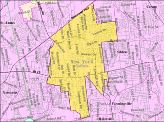
Farmingville is a hamlet and census-designated place (CDP) in the Suffolk County town of Brookhaven, New York, United States. The population was 15,481 at the 2010 census.

<span class="mw-page-title-main">Gordon Heights, New York</span> Hamlet and census-designated place in New York, United States

Gordon Heights is a hamlet and census-designated place (CDP) in the Town of Brookhaven, Suffolk County, Long Island, New York, United States. The population was 3,981 at the 2020 census.

<span class="mw-page-title-main">Holbrook, New York</span> Hamlet and census-designated place in New York, United States

Holbrook is a hamlet and census-designated place (CDP) in Suffolk County, New York, United States. The population was 27,195 at the 2010 census. The community borders the eastern side of Long Island MacArthur Airport.

<span class="mw-page-title-main">Holtsville, New York</span> Hamlet and census-designated place in New York, United States

Holtsville is a hamlet and census-designated place (CDP) in Suffolk County, on Long Island, in New York, United States. The population was 19,714 at the 2010 census.

<span class="mw-page-title-main">Huntington Station, New York</span> Hamlet and census-designated place in Suffolk County, New York, United States

Huntington Station is a hamlet and census-designated place (CDP) in the Town of Huntington in Suffolk County, on Long Island, in New York, in the United States. The population was reported as 34,878 with the 2020 census.

<span class="mw-page-title-main">Mastic, New York</span> Hamlet and census-designated place in New York, United States

Mastic is a hamlet and a census-designated place (CDP) in the southeastern part of the town of Brookhaven in central Suffolk County, New York, United States. The population was 15,481 at the 2010 census.

<span class="mw-page-title-main">Medford, New York</span> Hamlet & census-designated place in New York, United States

Medford is a hamlet and census-designated place (CDP) in the Town of Brookhaven in Suffolk County, on Long Island, in New York, United States. The population was 24,247 at the 2020 census.

<span class="mw-page-title-main">Nesconset, New York</span> Hamlet and census-designated place in New York, United States

Nesconset is a hamlet and census-designated place (CDP) in the town of Smithtown, located in Suffolk County, Long Island, New York, United States. The population was 13,387 at the 2010 census.

<span class="mw-page-title-main">North Amityville, New York</span> Hamlet and Census-designated place in New York, United States

North Amityville is a hamlet and census-designated place (CDP) in the Town of Babylon in Suffolk County, on the South Shore of Long Island, in New York. The population was 18,643 at the 2020 Census.

<span class="mw-page-title-main">North Bellport, New York</span> Hamlet and census-designated place in New York, United States

North Bellport is a hamlet and census-designated place (CDP) located within the Town of Brookhaven, New York, United States. The population was 11,545 at the 2010 census.

<span class="mw-page-title-main">Ridge, New York</span> Hamlet and census-designated place in New York, United States

Ridge is a hamlet and census-designated place (CDP) in the town of Brookhaven, Suffolk County, New York, United States. The population was 13,336 at the 2010 census.

<span class="mw-page-title-main">Stony Brook, New York</span> Hamlet and census-designated place in New York, United States

Stony Brook is a hamlet and census-designated place (CDP) in the Town of Brookhaven in Suffolk County, New York, United States, on the North Shore of Long Island. Begun in the colonial era as an agricultural enclave, the hamlet experienced growth first as a resort town and then to its current state as one of Long Island's major tourist towns and centers of education. Despite being referred to as a village by residents and tourists alike, Stony Brook has never been legally incorporated by the state. The population was 13,740 at the 2010 census.

<span class="mw-page-title-main">Wading River, New York</span> Hamlet and census-designated place in New York, United States

Wading River is a hamlet and census-designated place (CDP) in Suffolk County, New York, United States, on the North Shore of Long Island. As of the 2010 census, the CDP population was 7,719. It is adjacent to Shoreham and shares a school district.

<span class="mw-page-title-main">Brookhaven (CDP), New York</span> Hamlet and census-designated place in New York, United States

Brookhaven is a hamlet and census-designated place in Brookhaven Town, Suffolk County, New York, United States. The population was 3,451 at the 2010 census.

<span class="mw-page-title-main">Riverhead (CDP), New York</span> Hamlet and census-designated place in New York, United States

Riverhead is a census-designated place (CDP) roughly corresponding to the hamlet by the same name located in the Town of Riverhead in Suffolk County, on Long Island, in New York, United States. The CDP's population was 13,299 at the 2010 census.

<span class="mw-page-title-main">Smithtown (CDP), New York</span> Hamlet and census-designated place in New York, United States

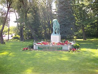
Smithtown is a hamlet and census-designated place (CDP) within the Town of Smithtown in Suffolk County, New York. The population was 25,629 at the 2020 census.

References

  1. "ArcGIS REST Services Directory". United States Census Bureau. Retrieved September 20, 2022.
  2. "Geographic Identifiers: 2010 Demographic Profile Data (G001): Port Jefferson Station CDP, New York". U.S. Census Bureau, American Factfinder. Archived from the original on February 12, 2020. Retrieved January 7, 2013.
  3. "New York State Route 347". newsday.com. Newsday. Archived from the original on October 1, 2005. Retrieved July 15, 2009.
  4. 1 2 3 4 "Long Island Index: Interactive Map". www.longislandindexmaps.org. Retrieved July 12, 2022.
  5. "Census of Population and Housing". Census.gov. Retrieved June 4, 2016.
  6. 1 2 3 "Profile of General Population and Housing Characteristics: 2010 Demographic Profile Data (DP-1): Port Jefferson Station CDP, New York". U.S. Census Bureau, American Factfinder. Archived from the original on February 12, 2020. Retrieved January 7, 2013.
  7. "Selected Economic Characteristics, 2007-2011 American Community Survey 5-Year Estimates (DP03): Port Jefferson Station CDP, New York". U.S. Census Bureau, American Factfinder. Archived from the original on February 12, 2020. Retrieved January 7, 2013.
  8. "System Map". sctbus.org. Suffolk County Transit . Retrieved October 31, 2023.