Hampton in Arden

Last updated

Hampton in Arden
The High Street Hampton in Arden.JPG
Hampton in Arden, High Street
West Midlands UK location map.svg
Red pog.svg
Hampton in Arden
Location within the West Midlands
Population1,834 (2011 Census)
OS grid reference SP205815
Civil parish
  • Hampton in Arden
Metropolitan borough
Metropolitan county
Region
Country England
Sovereign state United Kingdom
Post town SOLIHULL
Postcode district B92
Police West Midlands
Fire West Midlands
Ambulance West Midlands
UK Parliament
Website Welcome to the website for Hampton in Arden
List of places
UK
England
West Midlands
52°25′52″N1°42′00″W / 52.43110°N 1.69992°W / 52.43110; -1.69992

Hampton in Arden is a village and civil parish located in the Forest of Arden in the Metropolitan Borough of Solihull, in the West Midlands of England. Hampton in Arden was part of Warwickshire until the 1974 boundary changes. It lies within the Meriden Gap which is an area of countryside between Solihull and Coventry.

Contents

In 1968 the central part of the village was designated a Conservation Area, which is an "area of special architectural or historic interest, the character or appearance of which it is desirable to preserve or enhance". [1] Its population in the 2001 census was 1,787, [2] increasing to 1,834 at the 2011 Census. [3]

History

Hampton is mentioned in Domesday Book (1086), when it was held by Geoffrey de Wirce. "In Coleshill Hundred Hantone. 10 hides. Land for 22 ploughs. In lordship 2; 2 male and 2 female slaves. 50 villagers with a priest and 16 smallholders have 13 ploughs. A mill at 40d; meadow, 10 acres; woodland 3 leagues long and 3 wide. The value was and is 100s." All of Geffrey's lands were held freely by Leofwin. Geffrey's wife was called Aelfeva and her English name suggests that Geffrey may have acquired his Warwickshire lands through her, by inheritance rather than by confiscation; she may have been Leofwin's heiress. [4] A priest was recorded, implying that a church existed.

Of the name, Hantone, Dugdale states that the name was occasioned from the situation, "hean" in the Saxon signifying high though by contraction written "han" and through corrupt pronunciation "ham". [5]

Dugdale could find no mention of Geffrey having any children and concluded that he must have died without issue, his lands reverted to the Crown and by a grant of Henry I all his lands were passed to Nigel de Albani. Nigel had a son, Roger, surnamed Mowbray, from whom, from the middle of the 12th century the de Ardernes, became the Lords of the Manor. [5] Afterwards it passed by marriage to the de Montford family of Coleshill and then subsequently reverted to the Crown. It was granted to Robert Dudley, Earl of Leicester, by Queen Elizabeth I in 1570 but reverted to the Crown after his death. In 1625, it was assigned to Queen Henrietta Maria, wife of King Charles I. In the early 19th century it was sold to Isaac William Lillingston who later sold the Manor of Hampton to Sir Robert Peel (former Prime Minister and founder of the modern police force). On Sir Robert's death in 1850, the manor was inherited by his son, Frederick, who did much to 'modernise' Hampton, demolishing many half-timbered and thatched cottages. He employed the architect W E Nesfield to build new dwellings, shops and lodges. [1]

Notable landmarks

The parish church of St. Mary and St. Bartholomew

St. Mary and St. Bartholomew Hampton in Arden church - geograph.org.uk - 50337.jpg
St. Mary and St. Bartholomew
The Font St. Mary and St. Bartholomew the font.JPG
The Font
Heart Shrine and Priests door Heart Shrine and door.JPG
Heart Shrine and Priests door
Hampton in Arden Church, Warwickshire, S.E. (p.200, March 1824) Hampton in Arden Church, Warwickshire, S.E. (p.200, March 1824).jpg
Hampton in Arden Church, Warwickshire, S.E. (p.200, March 1824)
The East Window St. Mary and St. Bartholomew East Window.JPG
The East Window
Estate Cottages Hampton in Arden - Estate Cottages.jpg
Estate Cottages
War Memorial War Memorial Hampton in Arden.JPG
War Memorial

The parish church of St. Mary and St. Bartholomew has a chancel, nave with narrow aisles, west tower, south porch, and north vestry. The chancel is of about mid 12th-century date. It is comparatively long and narrow for the period, in a church of this size, and it has an unusual north doorway near the west end; it is possible that it represented the complete church, at least for a short time. The nave, if not coeval, was built soon afterwards and had a late-12th-century south aisle, of which the arcade remains. Possibly the nave was of the same width as the chancel, but was widened to the north about 5 ft (1.5 m). about the middle of the 13th century and a narrow north aisle and arcade added. The chancel arch was widened at the same time to the utmost limits permitted by the width of the chancel. For some reason, probably weakness, the north aisle was rebuilt late in the 14th century on the old foundations of the narrow aisle. This was followed by a similar rebuilding of the south aisle early in the 15th century, again without widening it. About the same time the west tower was begun, but carried up only a short way, the completion being delayed until late in the century. The last medieval alteration was the building of the clerestory in the 16th century in place of the old steeply pitched roof indicated by the lines on the tower. [7] The tower bore a tall spire "till by the extraordinary violence of lightning and thunder happening on St.Andrew's Day, in the night, in the year 1643, it was cloven, and fell to the ground: at which time the whole fabrick, with the tower, were torn in divers places." [5] The south porch and north vestry are modern, and various repairs and restorations have been executed to other parts. The chancel was rebuilt in 1879 with the old material [7] overseen by the architect W. E. Nesfield. [1] All the roofs are modern. [7] The church bells and most of their fittings were transplanted here from Manchester in 1976, where they had previously hung in the church of St John in Miles Platting, then being demolished due to subsidence. [8]

Other

Yew Tree Cottage Yew Tree Cottage.JPG
Yew Tree Cottage
Cottages on the High Street Cottages hampton in Arden.JPG
Cottages on the High Street

There are some well preserved 17th century and timber-framed houses, some of which are listed. [7] Outside the village, to the south-east, is the 15th-century packhorse bridge over the River Blythe and on the former route to Kenilworth. [1] Only 5 ft (1.5 m). wide between the low parapets, consisting of five bays with ancient stone piers having pointed cut-water faces on the west side against the flow of the stream—and square projections on the east. The three northern arches are segmental-pointed, the southern two have been rebuilt with brick arches. East of the bridge is a ford. [7]

15th-century Packhorse Bridge Packhorse Bridge.JPG
15th-century Packhorse Bridge

The war memorial lists the names of 23 men of the parish who were killed in World War I and one in World War II. It is dedicated; To the Glory of God and in Memory of the men of Hampton in Arden who gave their lives for their country in the cause of freedom 1914–1918 and below Sons of this place let this of you be said that you who live are worthy of your dead 1939–1945 ( there are 24 names from WW1 and 1 from WW2, one must have been added recently) .

Governance

Hampton in Arden is part of the Bickenhill ward of Solihull Metropolitan Borough Council, and is represented by Councillors Alison Rolf, Robert Sleigh and Jim Ryan, all of the Conservative Party. [9] Nationally, it is part of the constituency of Meriden, whose Member of Parliament is a Conservative, Saqib Bhatti. Prior to Brexit in 2020, it was included in the West Midlands electoral region of the European Parliament.

Hampton-in-Arden railway station Hampton-in-Arden railway station 1.jpg
Hampton-in-Arden railway station

The M42 motorway, Birmingham Airport and the National Exhibition Centre (NEC) are nearby.

Hampton was at the southern end of the Birmingham and Derby Junction Railway, later part of the Midland Railway. Opened as a double-track main line on 12 August 1839, the section from Whitacre to Hampton, known as the Stonebridge Railway, was downgraded to a branch line in 1842 after the opening of the line from Whitacre into Birmingham; it was singled in 1843 and lost its final passenger service in 1917 as a wartime economy measure. After lingering on as a goods line, it was closed entirely in 1935 following a bridge failure at Packwood. The line had originally enabled passengers from the Derby, Tamworth, Kingsbury, Whitacre, Shustoke and Coleshill areas to make connections at Hampton for other parts of the country, because at one time the Midland Railway and the London & North Western Railway (LNWR) had stations side by side at Hampton, at the point where the two lines met (called Derby Junction). The Midland station building can still be seen, but the LNWR station disappeared long ago, being replaced by the present Hampton-in-Arden railway station some 500m nearer London in 1884. The track bed of the old Midland route remains and a footpath for hikers and railway buffs runs alongside the site of the original track. Hampton is now served by hourly bus services 82 and 89 between Solihull and Coventry operated by Stagecoach in Warwickshire Although through fares are currently unavailable, most buses on service 82 continue from Solihull to Stratford upon Avon as service X20. The railway provides a link between Birmingham and Coventry approximately every 30 minutes Monday to Saturday.The village is namechecked in the Crokodile Tears song Trains.

Sports and leisure

The White Lion Public House The white Lion.JPG
The White Lion Public House

The village has one pub, the 17th-century The White Lion public house north-east of the church on the High Street, which is plastered externally, but old beams are exposed inside. [7] There is also one restaurant, the Beeches Bar & Grill, within an 18th-century Georgian building on Marsh Lane, with panel front door centred, topped with rectangular windows (in door or as a transom) and capped with an elaborate entablature supported by decorative pilasters. It began life as a private house but was later bought by the local George Fentham charity as a place of recreation for men. In 1913 a hall was built adjoining the house and the whole complex was used as a VAD Hospital during the First World War. After the war the hall became the equivalent of a village hall and the house reverted to being a working men's club. In the late 1980s the club was used less and less and an alternative use had to be found. In 1997 it was converted into, what is now, the Beeches Bar & Grill. Beeches Bar & Grill

Related Research Articles

<span class="mw-page-title-main">Knowle, West Midlands</span> Human settlement in England

Knowle is a large village situated 3 miles (5 km) east-southeast of the town of Solihull, West Midlands, England. Knowle lies within the Arden area of the historic county boundaries of Warwickshire, and since 1974 it has been part of the Metropolitan Borough of Solihull within the West Midlands. It lies 2.5 miles from the Warwickshire border and had a recorded population of 10,678.

<span class="mw-page-title-main">North Warwickshire</span> Borough and non-metropolitan district in England

North Warwickshire is a local government district with borough status in Warwickshire, England. The borough includes the two towns of Atherstone and Coleshill, and the large villages of Polesworth, Kingsbury, Hartshill and Water Orton along with smaller villages and surrounding rural areas.

<span class="mw-page-title-main">Metropolitan Borough of Solihull</span> Metropolitan borough in England

The Metropolitan Borough of Solihull is a metropolitan borough in West Midlands county, England. It is named after its largest town, Solihull, from which Solihull Metropolitan Borough Council is based. For Eurostat purposes it is a NUTS 3 region and is one of seven boroughs or unitary districts that comprise the "West Midlands" NUTS 2 region. Much of the large residential population in the north of the borough centres on the communities of Castle Bromwich, Kingshurst, Marston Green and Smith's Wood as well as the towns of Chelmsley Wood and Fordbridge. In the south are the towns of Shirley and Solihull, as well as the large villages of Knowle, Dorridge, Meriden and Balsall Common.

<span class="mw-page-title-main">Meriden, West Midlands</span> Human settlement in England

Meriden is a village and civil parish in the Metropolitan Borough of Solihull, West Midlands, England. Historically, it is part of Warwickshire and lies between the cities of Birmingham and Coventry. It is located close to the North Warwickshire district border within a green belt of the countryside known as the Meriden Gap and is in the ecclesiastical parish of the Diocese of Coventry.

<span class="mw-page-title-main">Water Orton</span> Human settlement in England

Water Orton is a village and civil parish in the North Warwickshire borough of Warwickshire in the West Midlands, England near the River Tame. It is located between Castle Bromwich and Coleshill, and borders the West Midlands metropolitan county boundary to the north, west and south. At the 2001 Census, the population was 3,573, falling to 3,444 at the 2011 Census. In the 2021 Census the population slightly rose to 3,487.

<span class="mw-page-title-main">Birmingham and Derby Junction Railway</span>

The Birmingham and Derby Junction Railway was a British railway company. From Birmingham it connected at Derby with the North Midland Railway and the Midland Counties Railway at what became known as the Tri Junct Station. It now forms part of the main route between the West Country and the North East.

<span class="mw-page-title-main">Olton</span> Human settlement in England

Olton is an area/suburban village within the Metropolitan Borough of Solihull in the West Midlands, England. In the 13th century, the Lords of the Manor moved their seat and formed a new settlement, at the junction of two major roads. It was then that Ulverlei was being referred to as ‘Oulton’ to distinguish itself from nearby Solihull. Historically within the county of Warwickshire, the village has gradually become contiguous with Solihull to the southeast, though it retains the character of a large independent village.

The Stonebridge Railway was a railway line between Whitacre Junction and Hampton-in-Arden in Warwickshire, England, passing through Stonebridge. It had an intermediate station at Coleshill, which was renamed Maxstoke in 1923.

<span class="mw-page-title-main">Hockley Heath</span> Human settlement in England

Hockley Heath is a large village and civil parish in the Arden area mostly within the Metropolitan Borough of Solihull, West Midlands, England. It incorporates the hamlet of Nuthurst, and has a history dating back to the year 705 AD as a wood owned by Worcester Cathedral. The parish, known as Nuthurst cum Hockley Heath, is to the south of the West Midlands conurbation, 12 miles (19 km) southeast of Birmingham 5.5 miles (8.9 km) from Solihull town centre and 13 miles (21 km) north of Stratford-upon-Avon. The village forms part of the border with Warwickshire and the District of Stratford-on-Avon to the south, with some parts of the village on either side of the border. According to the 2001 census, the parish had a population of 6,771, being measured at the 2011 Census as 2,038.

Ansley is a civil parish in Warwickshire consisting of Ansley, Ansley Common, Church End, Birchley Heath and, previously, Ansley Hall Colliery.

The Meriden Rural District was a rural district of Warwickshire, England, which existed between 1894 and 1974. It was named after the village of Meriden.

<span class="mw-page-title-main">Beaudesert, Warwickshire</span> Villages in England

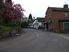
Beaudesert is a village, civil parish and former manor in the Stratford-on-Avon district of Warwickshire, England, immediately east across the River Alne to the east of Henley-in-Arden, to which it is closely associated and shares a joint parish council with. The main village, consisting of the church and a single short street of houses, stands close to the river and directly opposite Henley Church. Behind the village to the east rises the hill, locally known as 'The Mount', crowned with the earthwork remains of Beaudesert Castle of the De Montforts. According to the 2001 Census it had a population of 919, increasing to 990 at the 2011 Census.

Lea Marston is a village and civil parish on the River Tame in Warwickshire, England, about 7 miles (11 km) south-west of Atherstone. Lea Marston is close to the county boundary with Birmingham and about 4.5 miles (7.2 km) east of Sutton Coldfield.

<span class="mw-page-title-main">Shustoke</span> Human settlement in England

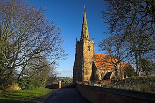
Shustoke is a village in the North Warwickshire district of the county of Warwickshire in England. The population of the civil parish at the 2011 census was 549. It is situated 2.5 miles northeast of Coleshill, 7.5 miles southwest of Atherstone, 9.5 miles west of Nuneaton and 12.5 miles east-northeast of Birmingham. It includes the sub-village of Church End half-a-mile to the east, where the parish church of Saint Cuthbert's is situated.

Whitacre Heath is a small village in the North Warwickshire district of the county of Warwickshire in England. It is one of 'The Whitacres' - Whitacre Heath, Nether Whitacre and Over Whitacre. Whitacre Heath is actually the heath of Nether Whitacre and not a separate parish. Whitacre Heath is newer and of 19th-century origin. It stems from the early days of railways in the 1830s, and from later developments by Joseph Chamberlain and the Water Department of the City of Birmingham. The Stonebridge Railway was opened on 12 August 1839 to provide a link between the Birmingham and Derby Junction Railway and the London and Birmingham Railway at Hampton in Arden, via Stonebridge. The line became redundant in the 1930s and the track bed is now a footpath for walkers. There are Victorian brick buildings for the management of drinking water, at Whitacre water works, which were originally associated with public works by the City of Birmingham. The village is now largely residential and agricultural.

<span class="mw-page-title-main">Nether Whitacre</span> Human settlement in England

Nether Whitacre is a small village and larger rural civil parish in North Warwickshire, Warwickshire, England.

<span class="mw-page-title-main">Solihull</span> Town in West Midlands, England

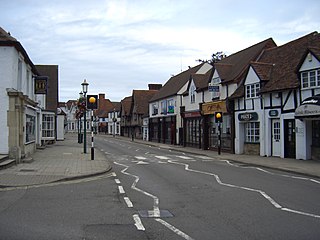
Solihull is a market town and the administrative centre of the Metropolitan Borough of Solihull, in the West Midlands, England. Solihull is situated on the River Blythe in the Forest of Arden area. The town had a population of 126,577 at the 2021 Census, and its wider borough had a population of 216,240. The town is located 8 miles (12 km) southeast of Birmingham and 13 miles (21 km) west of Coventry.

The Warwickshire Cricket League is the biggest cricket league for clubs in Warwickshire. Its origins go back to 1989, and since 1998 it has acted as a feeder league to the Birmingham and District Premier League Aston Manor in 2005, Berkswell in 2006, & Sutton Coldfield 2014 gained successive promotions from Birmingham League Division Three the following season. Olton and West Warwickshire Cricket Club are the current champions.

<span class="mw-page-title-main">Coughton, Warwickshire</span> Village in Warwickshire, England

Coughton is a small village located between Studley 2.4 miles (4 km) to the North and Alcester, 2 miles (3 km) to the South, in the county of Warwickshire, England. The village lies 19.3 miles (31 km) from Birmingham on the Birmingham–Alcester A435 road, which here follows the line of the Roman road Icknield Street. The village mainly consists of a number of houses on Sambourne Lane, Coughton Lane and farms and is primarily noted as being the location of the National Trust property, Coughton Court, which lies 400 yards to the east of the A435. The population according to the 2001 Census was 139, increasing to 157 in the 2011 Census.

<span class="mw-page-title-main">Whitacre Junction railway station</span> Former railway station in England

Whitacre Junction railway station was opened in 1864 by the Midland Railway. It served the village of Whitacre Heath, Warwickshire, England.

References

  1. 1 2 3 4 Solihull Council Web site
  2. Office for National Statistics : Census 2001 : Parish Headcounts : Solihull Retrieved 22 November 2009
  3. "Civil Parish population 2011" . Retrieved 16 December 2015.
  4. Domesday Book for Warwickshire, Phillimore edited by John Morris ISBN   0-85033-141-2
  5. 1 2 3 The Antiquities of Warwickshire, William Dugdale, 1656
  6. "The Gentleman's Magazine, and Historical Chronicle". The Gentleman's Magazine, and Historical Chronicle. 94 (1): 200. March 1824. Retrieved 13 December 2017.
  7. 1 2 3 4 5 6 A History of the County of Warwick: Volume 4(1947), pp. 81–86. Date accessed: 26 March 2010.
  8. "Hampton in Arden". warksbells.co.uk. Retrieved 11 April 2019.
  9. "Solihull Council Website: List of Councillors". Archived from the original on 19 January 2008. Retrieved 3 April 2010.