List of conservation areas in the West Midlands (county)

Last updated

This is a list of conservation areas in the West Midlands , England. There are a total of 137 conservation areas throughout the West Midlands.

Contents

Birmingham

Colmore Row and Environs, City Centre conservation area. ColmoreRowBirmingham.jpg
Colmore Row and Environs, City Centre conservation area.
St Edburgha's Church (Old Yardley Church) within the Old Yardley conservation area. Old Yardley Church, Birmingham.jpg
St Edburgha's Church (Old Yardley Church) within the Old Yardley conservation area.
The Warwick Bar stop lock and Banana Warehouse in the Warwick Bar conservation area. Warwick Bar stop lock and Banana Warehouse.jpg
The Warwick Bar stop lock and Banana Warehouse in the Warwick Bar conservation area.

Birmingham has 27 conservation areas. The first conservation areas in Birmingham were designated in 1969. [1] Birmingham City Council have designed 31 conservation areas, [2] of which one, St Peter's Place, have been de-designated in 1976 following the demolition of the church in its centre. [3] The Castle Bromwich Conservation Area was transferred to Solihull following a boundary amendment from 1 April 1988. The former Key Hill and St Paul's Conservation Areas were incorporated into the Jewellery Quarter Conservation Area on 27 September 2000. [2]

NameArea (ha)Date designatedAdditional designations
or notes
References Coordinates
(links to map & photo sources)
Anchorage Road, Sutton Coldfield 17.5715 October 1992None. [4] [5] 52°34′08″N1°49′26″W / 52.569°N 1.824°W / 52.569; -1.824
Aston Hall and Church 24.9827 January 1972Extended 6 February 1975 and 17 November 1977. [6] [7] [8] 52°30′22″N1°53′02″W / 52.506°N 1.884°W / 52.506; -1.884
Austin Village, Northfield/ Longbridge 13.2617 July 1997Covered by Article 4(2) Direction. [9] 52°24′04″N1°58′19″W / 52.401°N 1.972°W / 52.401; -1.972
Barnsley Road, Edgbaston 12.0719 May 1988None. [10] [11] 52°28′26″N1°57′47″W / 52.474°N 1.963°W / 52.474; -1.963
Bournville Tenants 9.14717 June 1971Extended 6 February 1975. [12] [13] 52°25′01″N1°56′49″W / 52.417°N 1.947°W / 52.417; -1.947
Bournville Village 76.8617 June 1971Covered by Article 4(2) Direction. Extended 7 October 1971, 18 June 1981 and 14 July 1994. [14] [15] [16] 52°25′52″N1°56′02″W / 52.431°N 1.934°W / 52.431; -1.934
Colmore Row and Environs, City Centre21.707 October 1971Extended 21 March 1985 and 5 July 1985. [17] [18] [19] [20] 52°28′52″N1°54′00″W / 52.481°N 1.900°W / 52.481; -1.900
Digbeth, Deritend, and Bordesley High Streets28.6831 May 2000None. [21] [22] 52°28′34″N1°53′02″W / 52.476°N 1.884°W / 52.476; -1.884
Edgbaston 395.44 September 1975Extended 13 December 1984, 17 September 1992 and 10 October 1992. [23] [24] [25] 52°27′40″N1°55′08″W / 52.461°N 1.919°W / 52.461; -1.919
Four Oaks, Sutton Coldfield 11410 July 1986None. [26] [27] 52°34′34″N1°49′55″W / 52.576°N 1.832°W / 52.576; -1.832
Harborne Old Village 24.7917 July 1969None. [28] [29] 52°27′11″N1°57′25″W / 52.453°N 1.957°W / 52.453; -1.957
High Street, Sutton Coldfield 16.9528 November 1973Partly covered by Article 4(1) Direction. Extended 6 February 1975, 14 August 1980 and 16 July 1992. [30] [31] 52°33′58″N1°49′23″W / 52.566°N 1.823°W / 52.566; -1.823
Ideal Village, Bordesley Green 17.5718 October 1990Covered by Article 4(2) Direction. [32] [33] 52°28′41″N1°50′10″W / 52.478°N 1.836°W / 52.478; -1.836
Jewellery Quarter 94.4310 January 1980Extended 18 January 1996 and 27 September 2000. [34] [35] [36] 52°29′17″N1°54′40″W / 52.488°N 1.911°W / 52.488; -1.911
Kings Norton 14.2817 July 1969None. [37] [38] 52°24′29″N1°55′48″W / 52.408°N 1.930°W / 52.408; -1.930
Lee Crescent, Edgbaston 2.3426 June 1974None. [39] [40] 52°28′08″N1°54′29″W / 52.469°N 1.908°W / 52.469; -1.908
Lozells and Soho Hill 34.4419 July 1979None. [41] 52°30′04″N1°55′08″W / 52.501°N 1.919°W / 52.501; -1.919
Moor Pool, Harborne 22.3230 July 1970Covered by Article 4(2) Direction. Character Appraisal and Management Plan adopted in March 2012. [42] [43] 52°27′47″N1°57′25″W / 52.463°N 1.957°W / 52.463; -1.957
Moseley 95.0617 March 1983Extended 12 November 1987 and 14 March 2005. [44] [45] 52°26′56″N1°53′35″W / 52.449°N 1.893°W / 52.449; -1.893
Northfield Old Village 4.07617 July 1969None. [46] [47] 52°24′40″N1°57′50″W / 52.411°N 1.964°W / 52.411; -1.964
Old Yardley 11.4717 July 1969Covered by Article 4(1) Direction). Extended 15 August 1974. [48] [49] 52°28′26″N1°48′11″W / 52.474°N 1.803°W / 52.474; -1.803
Ryland Road, Edgbaston 2.75913 March 1969None. [50] [51] 52°28′05″N1°54′32″W / 52.468°N 1.909°W / 52.468; -1.909
St Agnes, Moseley 27.5925 June 1987None. [52] [53] [54] 52°26′31″N1°52′37″W / 52.442°N 1.877°W / 52.442; -1.877
St Augustines, Edgbaston 13.4618 February 1988None. [55] [56] 52°28′23″N1°56′38″W / 52.473°N 1.944°W / 52.473; -1.944
School Road, Hall Green 6.38017 November 1988First designation of speculative semi-detached suburbia. [57] [58] [59] [60] 52°25′59″N1°50′13″W / 52.433°N 1.837°W / 52.433; -1.837
Steelhouse, City Centre11.074 October 1993None. [61] [62] [63] 52°29′02″N1°53′35″W / 52.484°N 1.893°W / 52.484; -1.893
Warwick Bar, Digbeth 16.1925 June 1987None. [64] [65] 52°28′44″N1°53′02″W / 52.479°N 1.884°W / 52.479; -1.884

Coventry

Birmingham Road in the Allesley Village conservation area. Allesley village 18o06.jpg
Birmingham Road in the Allesley Village conservation area.
Engine house and Coventry Canal (left), Oxford Canal (right) at the Hawkesbury Junction conservation area. Hawkesbury Junction.jpg
Engine house and Coventry Canal (left), Oxford Canal (right) at the Hawkesbury Junction conservation area.

Coventry has 15 conservation areas. The first conservation areas were designated in 1968. [66]

NameDate designatedAdditional designations
or notes
Coordinates
(links to map & photo sources)
Allesley Village 20 December 1968Extended 29 November 1994. 52°25′23″N1°33′29″W / 52.423°N 1.558°W / 52.423; -1.558
Kenilworth Road, Earlsdon 20 December 1968Extensions agreed 6 September 1978 with effect from 10 October 1978. Minor boundary adjustments approved 6 January 2004. 52°23′02″N1°32′10″W / 52.384°N 1.536°W / 52.384; -1.536
Stoke Green 20 December 1968Extension and other minor boundary adjustments approved 6 January 2004. 52°24′22″N1°28′52″W / 52.406°N 1.481°W / 52.406; -1.481
Greyfriars Green, City Centre8 August 1969Extended 6 April 1977. 52°24′14″N1°30′47″W / 52.404°N 1.513°W / 52.404; -1.513
Hill Top, City Centre8 August 1969"Outstanding" status given 14 December 1976 (since discontinued). Minor boundary adjustment approved 6 January 2004. 52°24′29″N1°30′25″W / 52.408°N 1.507°W / 52.408; -1.507
Lady Herbert's Garden, City Centre8 August 1969Extended 6 April 1977. Minor boundary adjustment approved 6 January 2004. 52°24′40″N1°30′29″W / 52.411°N 1.508°W / 52.411; -1.508
Spon Street, City Centre8 August 1969Extension to north and other minor boundary adjustments approved 6 January 2004. 52°24′29″N1°31′01″W / 52.408°N 1.517°W / 52.408; -1.517
Hawkesbury Junction 14 September 1976Designated jointly with Nuneaton & Bedworth Borough Council and ratified by the West Midlands County Council in October 1976. 52°27′25″N1°28′08″W / 52.457°N 1.469°W / 52.457; -1.469
Chapelfields 9 November 1976None. 52°24′25″N1°31′59″W / 52.407°N 1.533°W / 52.407; -1.533
London Road, north of Whitley 5 April 1977Given "outstanding" status 7 October 1977 (since discontinued). The Cemetery is now on the English Heritage Parks & Gardens register. 52°23′56″N1°29′46″W / 52.399°N 1.496°W / 52.399; -1.496
High Street, City Centre12 October 1982None. 52°24′25″N1°30′32″W / 52.407°N 1.509°W / 52.407; -1.509
Ivy Farm Lane, Canley 16 November 1989Minor boundary adjustments approved 6 January 2004. 52°23′13″N1°32′49″W / 52.387°N 1.547°W / 52.387; -1.547
Far Gosford Street, adjacent to the A460 21 October 1992None. 52°24′25″N1°29′38″W / 52.407°N 1.494°W / 52.407; -1.494
Naul's Mill 10 September 2003None. 52°24′47″N1°30′54″W / 52.413°N 1.515°W / 52.413; -1.515
Spon End 10 September 2003None. 52°24′40″N1°31′19″W / 52.411°N 1.522°W / 52.411; -1.522

Dudley

There are 21 conservation areas in Dudley. [67]

NameAdditional designations
or notes
Coordinates
(links to map & photo sources)
All Saints, Sedgley None. 52°32′24″N2°07′23″W / 52.540°N 2.123°W / 52.540; -2.123
Bumble Hole, Netherton None. 52°29′31″N2°04′19″W / 52.492°N 2.072°W / 52.492; -2.072
Castle Hill, Dudley None. 52°30′54″N2°04′44″W / 52.515°N 2.079°W / 52.515; -2.079
Church Road, Oldswinford None. 52°26′49″N2°08′10″W / 52.447°N 2.136°W / 52.447; -2.136
The Coppice, Coseley None. 52°32′28″N2°06′11″W / 52.541°N 2.103°W / 52.541; -2.103
Delph 'Nine' Locks, Brierley Hill None. 52°28′37″N2°07′12″W / 52.477°N 2.120°W / 52.477; -2.120
Dudley Town CentreNone. 52°30′32″N2°05′02″W / 52.509°N 2.084°W / 52.509; -2.084
High Street, Stourbridge None. 52°27′25″N2°08′46″W / 52.457°N 2.146°W / 52.457; -2.146
The Leasowes, Halesowen Article Four. 52°28′08″N2°03′54″W / 52.469°N 2.065°W / 52.469; -2.065
Love Lane, Oldswinford Article Four. 52°26′53″N2°08′46″W / 52.448°N 2.146°W / 52.448; -2.146
Lutley Mill, LutleyNone. 52°27′00″N2°04′37″W / 52.450°N 2.077°W / 52.450; -2.077
Mushroom GreenArticle Four. 52°28′34″N2°05′35″W / 52.476°N 2.093°W / 52.476; -2.093
Oak Street, Coseley None. 52°32′10″N2°05′24″W / 52.536°N 2.090°W / 52.536; -2.090
Parkhead Locks, DudleyNone. 52°29′53″N2°05′56″W / 52.498°N 2.099°W / 52.498; -2.099
Stourbridge Branch Canal (Amblecote)None. 52°28′01″N2°09′18″W / 52.467°N 2.155°W / 52.467; -2.155
Stourbridge Canal (Canal Street)None. 52°27′40″N2°09′07″W / 52.461°N 2.152°W / 52.461; -2.152
Stourbridge 16 Locks, Wordsley None. 52°28′41″N2°09′04″W / 52.478°N 2.151°W / 52.478; -2.151
The Village, Kingswinford Partly covered by Article Four. 52°30′04″N2°09′25″W / 52.501°N 2.157°W / 52.501; -2.157
Wollaston None. 52°27′36″N2°09′47″W / 52.460°N 2.163°W / 52.460; -2.163
Wordsley ChurchNone. 52°28′44″N2°09′36″W / 52.479°N 2.160°W / 52.479; -2.160
Wordsley HospitalNone. 52°29′06″N2°09′36″W / 52.485°N 2.160°W / 52.485; -2.160

Sandwell

There are six conservation areas in Sandwell. [68]

NameArea (ha)Date designatedAdditional designations
or notes
Coordinates
(links to map & photo sources)
Church Square, Oldbury 1.341974None. 52°30′11″N2°00′50″W / 52.503°N 2.014°W / 52.503; -2.014
Market Place, Wednesbury 3.111980None. 52°33′07″N2°01′05″W / 52.552°N 2.018°W / 52.552; -2.018
Smethwick Summit (Galton Valley)47.481985None. 52°29′49″N1°58′19″W / 52.497°N 1.972°W / 52.497; -1.972
Factory Locks, Tipton 2.621986None. 52°31′52″N2°04′16″W / 52.531°N 2.071°W / 52.531; -2.071
High Street, West Bromwich 11.801990Extended 1995 and 1997. 52°31′12″N1°59′49″W / 52.520°N 1.997°W / 52.520; -1.997
Warrens Hall 33.981994None. 52°29′38″N2°03′54″W / 52.494°N 2.065°W / 52.494; -2.065

Solihull

Berkswell village green. Berkswell village green 1308.JPG
Berkswell village green.
Knowle High Street. Knowle highstreet.JPG
Knowle High Street.

There are 20 conservation areas in Solihull. [69]

Name Coordinates
(links to map & photo sources)
Ashleigh Road 52°25′01″N1°47′13″W / 52.417°N 1.787°W / 52.417; -1.787
Barston 52°24′00″N1°41′46″W / 52.400°N 1.696°W / 52.400; -1.696
Berkswell 52°24′32″N1°38′28″W / 52.409°N 1.641°W / 52.409; -1.641
Bickenhill 52°26′13″N1°43′26″W / 52.437°N 1.724°W / 52.437; -1.724
Castle Bromwich 52°30′25″N1°47′17″W / 52.507°N 1.788°W / 52.507; -1.788
Granville Road, Dorridge 52°22′12″N1°44′49″W / 52.370°N 1.747°W / 52.370; -1.747
Grove AvenueUnknown
Hampton-in-Arden 52°25′37″N1°42′04″W / 52.427°N 1.701°W / 52.427; -1.701
Knowle 52°23′17″N1°44′02″W / 52.388°N 1.734°W / 52.388; -1.734
Malvern Hall and Brueton Avenue 52°24′43″N1°46′08″W / 52.412°N 1.769°W / 52.412; -1.769
Malvern Park Farm 52°23′56″N1°46′16″W / 52.399°N 1.771°W / 52.399; -1.771
Meriden Green 52°26′13″N1°38′56″W / 52.437°N 1.649°W / 52.437; -1.649
Meriden Hill 52°26′10″N1°39′07″W / 52.436°N 1.652°W / 52.436; -1.652
Olton 52°25′41″N1°48′40″W / 52.428°N 1.811°W / 52.428; -1.811
Solihull 52°24′43″N1°46′34″W / 52.412°N 1.776°W / 52.412; -1.776
Station Approach, Dorridge 52°22′19″N1°45′11″W / 52.372°N 1.753°W / 52.372; -1.753
Temple Balsall 52°22′52″N1°41′56″W / 52.381°N 1.699°W / 52.381; -1.699
Walsal End 52°24′43″N1°42′14″W / 52.412°N 1.704°W / 52.412; -1.704
Warwick Road 52°25′01″N1°46′52″W / 52.417°N 1.781°W / 52.417; -1.781
Whitehouse Green 52°24′40″N1°47′42″W / 52.411°N 1.795°W / 52.411; -1.795

Walsall

There are 18 conservation areas in Walsall. The first were designated in 1977. [70]

NameArea (ha)Date designated Coordinates
(links to map & photo sources)
Aldridge 3825 March 1980 52°36′18″N1°54′47″W / 52.605°N 1.913°W / 52.605; -1.913
Walsall Arboretum 31.3219 April 1989 52°35′24″N1°58′19″W / 52.590°N 1.972°W / 52.590; -1.972
Bloxwich High Street Unknown.18 October 2002 52°37′01″N2°00′14″W / 52.617°N 2.004°W / 52.617; -2.004
Bloxwich Park9.4113 December 1989 52°37′08″N2°00′18″W / 52.619°N 2.005°W / 52.619; -2.005
Bradford Street6.0517 April 1991 52°34′48″N1°59′06″W / 52.580°N 1.985°W / 52.580; -1.985
Bridge Street5.513 July 1983 52°35′02″N1°58′52″W / 52.584°N 1.981°W / 52.584; -1.981
Caldmore Green 1.518 March 1987 52°34′59″N1°58′52″W / 52.583°N 1.981°W / 52.583; -1.981
Church Hill20.59 March 1979 52°34′52″N1°58′37″W / 52.581°N 1.977°W / 52.581; -1.977
Darlaston 6.57 February 1977 52°34′05″N2°01′59″W / 52.568°N 2.033°W / 52.568; -2.033
Elmore Green, Bloxwich 7.7319 April 1990 52°36′50″N2°00′14″W / 52.614°N 2.004°W / 52.614; -2.004
Great Barr 76412 January 1996 52°34′08″N1°55′01″W / 52.569°N 1.917°W / 52.569; -1.917
Highgate 10.212 October 1994 52°34′34″N1°58′30″W / 52.576°N 1.975°W / 52.576; -1.975
Lichfield Street6.96 July 1988 52°35′10″N1°58′41″W / 52.586°N 1.978°W / 52.586; -1.978
Old Pelsall 3.920 August 1986 52°37′34″N1°58′41″W / 52.626°N 1.978°W / 52.626; -1.978
Old Rushall 7.0726 October 1983 52°35′49″N1°57′50″W / 52.597°N 1.964°W / 52.597; -1.964
Pelsall Common 57.52 March 1979 52°37′34″N1°58′01″W / 52.626°N 1.967°W / 52.626; -1.967
Walsall Locks5.518 March 1987 52°35′17″N1°59′35″W / 52.588°N 1.993°W / 52.588; -1.993
Willenhall 7.728 January 1977 52°35′02″N2°03′18″W / 52.584°N 2.055°W / 52.584; -2.055

Wolverhampton

There are 30 conservation areas in Wolverhampton, more than any other metropolitan borough in the West Midlands. The first conservation area was designated in 1972. [71] [72] [73]

NameDate designatedAdditional designations
or notes
Coordinates
(links to map & photo sources)
Ash Hill13 October 1994None. 52°35′06″N2°09′54″W / 52.585°N 2.165°W / 52.585; -2.165
Bantock House 12 October 1989None. 52°34′44″N2°09′14″W / 52.579°N 2.154°W / 52.579; -2.154
Bilston Town Centre 1975Boundaries were adjusted 30 September 2002. 52°33′58″N2°04′26″W / 52.566°N 2.074°W / 52.566; -2.074
Bushbury Hill 1972Boundaries were adjusted 25 June 1974. 52°37′30″N2°06′18″W / 52.625°N 2.105°W / 52.625; -2.105
Castlecroft Gardens28 July 1988None. 52°34′37″N2°10′34″W / 52.577°N 2.176°W / 52.577; -2.176
Cedar Way22 April 1999None. 52°36′25″N2°05′17″W / 52.607°N 2.088°W / 52.607; -2.088
Chapel Ash11 April 1991None. 52°35′02″N2°08′13″W / 52.584°N 2.137°W / 52.584; -2.137
Cleveland Road, City Centre13 June 1996None. 52°34′52″N2°07′12″W / 52.581°N 2.120°W / 52.581; -2.120
Copthorne Road2001Boundaries were adjusted 4 March 2002. 52°34′16″N2°08′28″W / 52.571°N 2.141°W / 52.571; -2.141
Fellows Street, Blakenhall 26 November 2001None. 52°34′30″N2°07′48″W / 52.575°N 2.130°W / 52.575; -2.130
Old Hall Street, City Centre26 October 1995None. 52°34′59″N2°07′26″W / 52.583°N 2.124°W / 52.583; -2.124
Park1975Boundaries were adjusted 12 October 1995. 52°35′24″N2°08′24″W / 52.590°N 2.140°W / 52.590; -2.140
Penn Fields 14 April 1994None. 52°34′01″N2°08′49″W / 52.567°N 2.147°W / 52.567; -2.147
Penn Road, Graiseley 24 July 1997None. 52°34′23″N2°08′17″W / 52.573°N 2.138°W / 52.573; -2.138
Springfield Brewery3 October 2003None. 52°35′31″N2°07′16″W / 52.592°N 2.121°W / 52.592; -2.121
St John's Square1972Boundaries were adjusted in 1986 and on 12 October 1989. 52°34′52″N2°07′41″W / 52.581°N 2.128°W / 52.581; -2.128
St Philips, Penn Fields 10 October 1991None. 52°33′58″N2°09′32″W / 52.566°N 2.159°W / 52.566; -2.159
Staffordshire and Worcestershire & Shropshire Union Canal 14 October 1993None. 52°36′54″N2°08′46″W / 52.615°N 2.146°W / 52.615; -2.146
Tettenhall Greens 1972Boundaries were adjusted 14 July 2003. 52°36′00″N2°10′19″W / 52.600°N 2.172°W / 52.600; -2.172
Tettenhall Road1 December 2004None. 52°35′31″N2°09′11″W / 52.592°N 2.153°W / 52.592; -2.153
Tettenhall Wood6 November 1975None. 52°35′38″N2°11′17″W / 52.594°N 2.188°W / 52.594; -2.188
The Oaks, Merridale 1 December 2004None. 52°35′02″N2°08′35″W / 52.584°N 2.143°W / 52.584; -2.143
The Woodlands17 June 1976None. 52°33′43″N2°09′18″W / 52.562°N 2.155°W / 52.562; -2.155
Union Mill1985Boundaries were adjusted 14 March 2007. 52°35′17″N2°07′01″W / 52.588°N 2.117°W / 52.588; -2.117
Vicarage Road, Penn 1972Boundaries were adjusted 17 June 1976. 52°33′22″N2°09′36″W / 52.556°N 2.160°W / 52.556; -2.160
Wednesfield 1988Boundaries were adjusted 13 January 1994. 52°35′56″N2°04′59″W / 52.599°N 2.083°W / 52.599; -2.083
Wightwick Bank 12 October 1989None. 52°34′55″N2°11′35″W / 52.582°N 2.193°W / 52.582; -2.193
Wolverhampton Locks1975Boundaries were adjusted 14 March 2007. 52°36′22″N2°08′28″W / 52.606°N 2.141°W / 52.606; -2.141
Wolverhampton City Centre1972Boundaries were adjusted in 1974, 1975, 1976, 1991, 2005 and on 14 March 2007. 52°35′13″N2°07′41″W / 52.587°N 2.128°W / 52.587; -2.128
Worcester Street, City Centre26 October 1995None. 52°34′55″N2°07′48″W / 52.582°N 2.130°W / 52.582; -2.130

See also

Related Research Articles

<span class="mw-page-title-main">West Midlands (county)</span> County of England

West Midlands is a metropolitan and ceremonial county in the larger West Midlands region of England. A landlocked county, it is bordered by Staffordshire to the north and west, Worcestershire to the south, and is surrounded by Warwickshire to the east. The largest settlement is the city of Birmingham.

<span class="mw-page-title-main">West Midlands Metro</span> Light rail system in the West Midlands, England

The West Midlands Metro is a light-rail/tram system in the county of West Midlands, England. The network has 33 stops with a total of 14 miles (23 km) of track; it currently consists of a single route, Line 1, which operates between the cities of Birmingham and Wolverhampton via the towns of Bilston, West Bromwich and Wednesbury, on a mixture of former railway lines and urban on-street running. The system is owned by the public body Transport for West Midlands, and operated by Midland Metro Limited, a company wholly owned by the West Midlands Combined Authority.

Edgbaston is a suburb of Birmingham, West Midlands, England. It lies immediately south-west of Birmingham city centre, and was historically in Warwickshire. The wards of Edgbaston and North Edgbaston had a combined population of 42,295 at the 2021 census.

<span class="mw-page-title-main">Harborne</span> Human settlement in England

Harborne is an area of south-west Birmingham, England. It is located three miles southwest from Birmingham city centre. It is a Birmingham City Council ward in the formal district and in the parliamentary constituency of Birmingham Edgbaston.

<span class="mw-page-title-main">Digbeth</span> Human settlement in England

Digbeth is an area of central Birmingham, England. Following the destruction of the Inner Ring Road, Digbeth is now considered a district within Birmingham City Centre. As part of the Big City Plan, Digbeth is undergoing a large redevelopment scheme that will regenerate the old industrial buildings into apartments, retail premises, offices and arts facilities. The district is considered to be Birmingham's 'Creative Quarter'.

Sport has always been important in Birmingham, England, from the hundreds of diverse grass-roots sports clubs to internationally famous teams, associations and venues.

As with any large town or city, food and drink has played an important role in the commerce and culture of Birmingham, England.

<span class="mw-page-title-main">Jewellery Quarter</span> Human settlement in England

The Jewellery Quarter is an area of central Birmingham, England, in the north-western area of Birmingham City Centre, with a population of 19,000 in a 1.07-square-kilometre (264-acre) area.

<span class="mw-page-title-main">Bordesley, Birmingham</span> Human settlement in England

Bordesley is an area of Birmingham, England, 1.2 miles (2 km) south east of the city centre straddling the Watery Lane Middleway ring road. It should not be confused with nearby Bordesley Green. Commercial premises dominate to the west of the ring road, but much of this area is to be redeveloped. Blocks of residential apartments are planned and set for completion from the mid-2020s onwards. The largely residential area east of the ring road was renamed Bordesley Village following large scale clearance of back-to-back houses and redevelopment in the 1980s and 90s. Bordesley is the real life setting of the BBC series Peaky Blinders, and home to Birmingham City Football Club's ground, St Andrew's.

<span class="mw-page-title-main">J. A. Chatwin</span> British architect

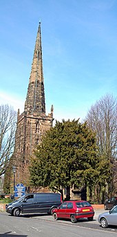
Julius Alfred Chatwin FRIBA, ARBS, FSAScot was a British architect. He was involved with the building and modification of many churches in Birmingham, and practised both Neo-Gothic and Neo-Classical styles. His designs always included all of the carvings and internal fittings.

<span class="mw-page-title-main">Digbeth Branch Canal</span>

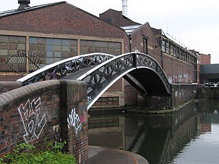
The Digbeth Branch Canal in Birmingham, England is a short canal which links the mainline of the Birmingham and Fazeley Canal at Aston Junction and the Grand Union Canal at Digbeth Junction in Digbeth, a district in Birmingham, England.

This article is intended to show a timeline of events in the History of Birmingham, England, with a particular focus on the events, people or places that are covered in Wikipedia articles.

<span class="mw-page-title-main">Birmingham city centre</span> City in the West Midlands, England

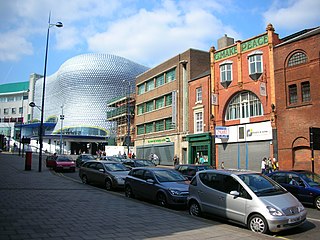
Birmingham city centre, also known as Central Birmingham, is the central business district of Birmingham, England. The area was historically in Warwickshire. Following the removal of the Inner Ring Road, the city centre is now defined as being the area within the Middle Ring Road. The city centre is undergoing massive redevelopment with the Big City Plan, which means there are now nine emerging districts and the city centre is approximately five times bigger.

Bournville College is a further education college based in Longbridge, Birmingham, England. The college offers courses that include A Levels, BTECs, NVQs, apprenticeships, and bespoke qualifications.

<span class="mw-page-title-main">Moor Pool</span> Garden Suburb in England

Moor Pool is a 22.32 hectares garden suburb within the ward of Harborne, Birmingham, England. It was designated a Conservation Area in July 1970, which was raised by an Article 4(2) direction order in 2006. A Conservation Area Character Appraisal and Management Plan was adopted in March 2012.

References

  1. "Birmingham's Conservation Areas". Birmingham City Council. Retrieved 26 October 2007.
  2. 1 2 "Conservation Area Properties Index". Birmingham City Council. 27 September 2000. Retrieved 23 August 2008.
  3. Larkham, Peter J. (1996). Conservation and the City. Routledge. p. 92. ISBN   0-415-07947-0.
  4. "Anchorage Road Conservation Area Map". Birmingham City Council. Retrieved 27 March 2008.
  5. "Anchorage Road Conservation Area Designation Report". Birmingham City Council. Retrieved 27 March 2008.
  6. "Aston Hall and Church Conservation Area Map". Birmingham City Council. Retrieved 27 March 2008.
  7. "Aston Hall and Church Conservation Area Designation Report". Birmingham City Council. Retrieved 27 March 2008.
  8. "Aston Hall". Birmingham City Council. Archived from the original on 5 March 2008. Retrieved 27 March 2008.
  9. "Austin Village Conservation Area Map". Birmingham City Council. Retrieved 27 March 2008.
  10. "Barnsley Road Conservation Area Map". Birmingham City Council. Retrieved 27 March 2008.
  11. "Barnsley Road Conservation Area Designation Report". Birmingham City Council. Retrieved 27 March 2008.
  12. "Bournville Tenants Conservation Area Map". Birmingham City Council. Retrieved 27 March 2008.
  13. "Bournville Tenants Conservation Area Designation Report". Birmingham City Council. Retrieved 27 March 2008.
  14. "Bournville Village Conservation Area Map". Birmingham City Council. Retrieved 27 March 2008.
  15. "Bournville Design Guide". Birmingham City Council. Retrieved 27 March 2008.
  16. "Bournville Village Conservation Area Designation Report". Birmingham City Council. Retrieved 27 March 2008.
  17. "Colmore Row and Environs Conservation Area Map". Birmingham City Council. Retrieved 27 March 2008.
  18. "Colmore Row and Environs Conservation Area Designation Report". Birmingham City Council. Retrieved 27 March 2008.
  19. "Character Appraisal and Supplementary Planning Policies". Birmingham City Council. Archived from the original on 13 March 2008. Retrieved 27 March 2008.
  20. "Colmore Row and Environs Conservation Area". Birmingham City Council. Retrieved 27 March 2008.
  21. "Digbeth, Deritend and Bordesley High Streets Conservation Area Map". Birmingham City Council. Retrieved 27 March 2008.
  22. "Digbeth Deritend & Bordesley High Streets Designation Report". Birmingham City Council. Retrieved 27 March 2008.
  23. "Edgbaston Conservation Area Map". Birmingham City Council. Retrieved 27 March 2008.
  24. "Edgbaston Conservation Area Designation Report". Birmingham City Council. Retrieved 27 March 2008.
  25. "Edgbaston Character Appraisal". Birmingham City Council. Retrieved 27 March 2008.
  26. "Four Oaks Conservation Area Map". Birmingham City Council. Retrieved 27 March 2008.
  27. "Four Oaks Conservation Area Designation Report". Birmingham City Council. Retrieved 27 March 2008.
  28. "Harborne Old Village Conservation Area Map". Birmingham City Council. Retrieved 27 March 2008.
  29. "Harborne Old Village Conservation Area Designation Report". Birmingham City Council. Retrieved 27 March 2008.
  30. "High Street Sutton Coldfield Conservation Area Map". Birmingham City Council. Retrieved 27 March 2008.
  31. "High Street Sutton Coldfield Conservation Area Designation Report". Birmingham City Council. Retrieved 27 March 2008.
  32. "Ideal Village Bordesley Green Conservation Area Map". Birmingham City Council. Retrieved 27 March 2008.
  33. "Ideal Village Bordesley Green Conservation Area Designation Report". Birmingham City Council. Retrieved 27 March 2008.
  34. "Jewellery Quarter Conservation Area Map". Birmingham City Council. Retrieved 27 March 2008.
  35. "Jewellery Quarter Conservation Area Designation Report". Birmingham City Council. Retrieved 27 March 2008.
  36. "Jewellery Quarter Regeneration Partnership". Birmingham City Council. Archived from the original on 5 March 2008. Retrieved 27 March 2008.
  37. "Kings Norton Conservation Area Map". Birmingham City Council. Retrieved 27 March 2008.
  38. "Kings Norton Conservation Area Designation Report". Birmingham City Council. Retrieved 27 March 2008.
  39. "Lee Crescent Edgbaston Conservation Area Map". Birmingham City Council. Retrieved 27 March 2008.
  40. "Lee Crescent Edgbaston Conservation Area Designation Report". Birmingham City Council. Retrieved 27 March 2008.
  41. "Lozells and Soho Hill Conservation Area Map". Birmingham City Council. Retrieved 27 March 2008.
  42. "Moor Pool Harborne Conservation Area Map". Birmingham City Council. Retrieved 27 March 2008.
  43. "Moor Pool Harborne Conservation Area Designation Report". Birmingham City Council. Retrieved 27 March 2008.
  44. "Moseley Conservation Area Map". Birmingham City Council. Retrieved 27 March 2008.
  45. "Moseley Conservation Area Designation Report". Birmingham City Council. Retrieved 27 March 2008.
  46. "Northfield Old Village Conservation Area Map". Birmingham City Council. Retrieved 27 March 2008.
  47. "Northfield Old Village Conservation Area Designation Report". Birmingham City Council. Retrieved 27 March 2008.
  48. "Old Yardley Conservation Area Map". Birmingham City Council. Retrieved 27 March 2008.
  49. "Old Yardley Conservation Area Designation Report". Birmingham City Council. Retrieved 27 March 2008.
  50. "Ryland Road Edgbaston Conservation Area Map". Birmingham City Council. Retrieved 27 March 2008.
  51. "Ryland Road Conservation Area Designation Report". Birmingham City Council. Retrieved 27 March 2008.
  52. "St Agnes Moseley Conservation Area Map". Birmingham City Council. Retrieved 27 March 2008.
  53. "St Agnes Moseley Conservation Area Designation Report". Birmingham City Council. Retrieved 27 March 2008.
  54. "St Agnes Leaflet". Birmingham City Council. Retrieved 27 March 2008.
  55. "St Augustines Edgbaston Conservation Area Map". Birmingham City Council. Retrieved 27 March 2008.
  56. "St Augustines Edgbaston Conservation Area Designation Report". Birmingham City Council. Retrieved 27 March 2008.
  57. "School Road Hall Green Conservation Area Map". Birmingham City Council. Retrieved 27 March 2008.
  58. "School Road Hall Green Conservation Area Designation Report". Birmingham City Council. Retrieved 27 March 2008.
  59. "School Road Character Appraisal". Birmingham City Council. Retrieved 27 March 2008.
  60. Stanilov, Kiril; Brenda Case Scheer (2004). Suburban Form: An International Perspective. Routledge. p. 247. ISBN   0-415-31476-3.
  61. "Steelhouse City Centre Conservation Area Map". Birmingham City Council. Retrieved 27 March 2008.
  62. "Steelhouse City Centre Conservation Area Designation Report". Birmingham City Council. Retrieved 27 March 2008.
  63. "Character Appraisal and Supplementary Planning Policies". Birmingham City Council. Retrieved 27 March 2008.
  64. "Warwick Bar Digbeth Conservation Area Map". Birmingham City Council. Retrieved 27 March 2008.
  65. "Warwick Bar Digbeth Conservation Area Designation Report". Birmingham City Council. Retrieved 27 March 2008.
  66. "List of conservation areas". Coventry City Council. Retrieved 27 March 2008.
  67. "Conservation Area Plans". Dudley Metropolitan Borough Council. Archived from the original on 8 June 2008. Retrieved 27 March 2008.
  68. "Conservation". Sandwell Metropolitan Borough Council. Archived from the original on 12 June 2008. Retrieved 27 March 2008.
  69. "Conservation Areas". Solihull Metropolitan Borough Council. Retrieved 27 March 2008.
  70. "Conservation areas". Walsall Council. Retrieved 27 March 2008.
  71. "Conservation areas". Wolverhampton City Council. Archived from the original on 21 November 2008. Retrieved 27 March 2008.
  72. "Wolverhampton Conservation Areas – Summary" (PDF). Wolverhampton City Council. March 2007. Archived from the original (PDF) on 26 September 2007. Retrieved 27 March 2008.
  73. "Conservation Areas in Wolverhampton" (PDF). Wolverhampton City Council. Archived from the original (PDF) on 26 September 2007. Retrieved 27 March 2008.