Wollaston, West Midlands

Last updated

Wollaston
West Midlands UK location map.svg
Red pog.svg
Wollaston
Location within the West Midlands
Population13,092 (2011.Ward. Wollaston and Stourbridge Town) [1]
OS grid reference SO888849
Metropolitan borough
Metropolitan county
Region
Country England
Sovereign state United Kingdom
Post town Stourbridge
Postcode district DY7 DY8
Police West Midlands
Fire West Midlands
Ambulance West Midlands
UK Parliament
List of places
UK
England
West Midlands
52°27′43″N2°09′59″W / 52.46193°N 2.16627°W / 52.46193; -2.16627

Wollaston is a village on the outskirts of Stourbridge in the English West Midlands. It is located in the south of the Dudley Metropolitan Borough, one mile west of Stourbridge town centre.

Contents

Etymology

The name Wollaston is taken to originate from the personal name Wulflāf and farm. Documents show various forms of the name, including Woolweston in 1708. [2]

History

Unlike namesakes Wollaston, Northamptonshire and Wollaston, Shropshire, this Wollaston is not listed in the Domesday Survey of 1086. [3]

A map from 1782 shows Wollaston Hall and a cluster of cottages where today Vicarage Road meets High Street. By 1827 this oldest part of the village included a windmill and the Barley Mow Inn; in addition there was a watermill on the Stour and a few cottages around the Gate Hangs Well Inn where High Park Avenue meets the Bridgnorth Road. [4] :9–10

Until 1974 when the West Midlands Metropolitan County was created, Wollaston was in Worcestershire.

Wollaston Hall

Wollaston Hall was a 17th-century mansion which stood in the village until 1926. Victoria County History of 1913 describes the front elevation of "five gables filled with ornamental half-timbering disposed in quatrefoil panels". [5] The Hall was later disassembled and shipped to North America, although nobody has been able to determine what happened to it. Panelling and a fireplace from the Hall are in the Edsel and Eleanor Ford House in Grosse Pointe Shores, Michigan. [6] The Wollastone Hall site was redeveloped for housing in the 1930s. [4] :30

Birthplace of steam locomotive

The Stourbridge Lion, built in Wollaston, was the first steam locomotive to run on a commercial line in the United States. Built by Foster, Rastrick and Company in Wollaston, the Stourbridge Lion's historic first run took place on 8 August 1829. The locomotive is now on view at the B&O Railroad museum, Baltimore MD, on loan from the Smithsonian Institution, Washington.

The foundry in Lowndes Road where the Stourbridge Lion was built, was under threat of demolition until work started in 2013/2014 to form the multimillion-pound Lion Health Centre.

Wollaston village school

Wollastone New Schools next to St James' Church opened on 28 February 1859. G Bidlake of Wolverhampton was architect. The buildings initially housed a mixed infants school and a separate school for older boys. A Girls' School had opened by 1861. Edward Hackwood, the first headmaster of the Boys' School held the position for 40 years. Joe Pearson, who had previously played football for Aston Villa and was a member of the club's 1905 FA Cup winning team was appointed headmaster in September 1919. The schools had capacity for 534 children in 1926. Pearson retired as headmaster in April 1946; he was also Mayor of Stourbridge for two years from November 1941. The school was extended in 1959 with the building of a hall, two classrooms, offices and a lavatory block and became a Junior School after the Infants were transferred to Meadow Park Infants' School. Wollaston School closed in 1984; the original buildings have been converted for use as offices. [4] :66–78

Historical population

Population of Wollaston township/parish taken from national censuses.

Population growth in Wollaston 1871–1951
YearPop.±%
18712,166    
18812,414+11.4%
18912,333−3.4%
19012,655+13.8%
19113,088+16.3%
19213,160+2.3%
19314,048+28.1%
19515,747+42.0%
Source: A Vision of Britain through Time

Wollaston Farm

The land of Wollastone Farm began to be developed for housing in the early 1950s. [4] :181–2 The almost circular Kingsway is the main road; roads off were named after English counties. [7] The Wollaston Free Church building on Somerset Drive started out as the clubhouse of Stourbridge Rugby Club. It was first used for worship in 1967; a foyer, heightened roof and illuminated spire have since been added. [4] :130–1

Wollaston Illuminations

The "Wollaston Illuminations" in Leonard Road were an annual Christmas lights display which attracted people from all over the Black Country [ citation needed ] to raise money for a chosen charity. Johnny Briggs, who played Mike Baldwin in the ITV soap Coronation Street and who lived in Stourbridge, switched on the lights several times over the years. In 2006, residents of Leonard Road decided to cancel the illuminations as a protest to food and drink vendors 'cashing in' on the fundraising event. [8]

Present

Wollaston's main thoroughfare is Bridgnorth Road (A458), which is home to a few pubs, restaurants and shops. The Unicorn Inn is a Bathams pub which was built in 1859. [9]

In 2014, Lion Health medical centre opened in the renovated former foundry of Foster, Rastrick and Company, a Grade II listed building. The next phase of regeneration on the foundry site will create parkland next to Stourbridge Canal with a "heritage and community hub" named Riverside House.

Governance

Wollaston is part of the Wollaston and Stourbridge Town ward for elections to Dudley Metropolitan Borough Council. [10] For elections to the House of Commons it is part of Stourbridge constituency.

Public services were the responsibility of the Vestry Committee from the formation of the parish in 1860 until the Local Government Act, 1894 curtailed its powers. The Vestry Committee, among other functions, installed streetlamps, named new roads and renamed existing ones, provided number plates for houses and street name signage, and was responsible for road maintenance. Wollaston chose to become part of Stourbridge Urban District rather than becoming a separate civil parish and in December 1894 elected three of twenty one councillors to serve on the new urban district council. Wollaston also elected one councillor to Worcestershire County Council. [4] :39–44

Education

Wollaston has two primary schools The Ridge Primary School, [11] which opened in 1968 and St James's C of E Primary, [12] a merger in 1984 of the village school with Meadow Park Infants' School. [4] :78

Ridgewood High School is on the site of High Park School, which opened in 1958. High Park merged with Longlands School in 1990 to form Ridgewood. [4] :80–1

Religious sites

Authorisation for the creation of the new parish of Wollaston was given by the Ecclesiastical Commissioners on 10 November 1859. Prior to this Wollaston was part of the ancient parish of Oldswinford. St James' Church was formally opened on 15 April 1960 on land donated by William Orme Foster of John Bradley & Co iron works and Member of Parliament for South Staffordshire. [4] :121–2 The church is of blue brick and bath stone and The Builder describes the style as fourteenth century Gothic. The architect was G Bidlake of Wolverhampton. [13] The church and its surrounding railings and gatepiers together with the vicarage are Grade II listed. [14] [15] [16] A vestry was added in October 1935 and the church hall was opened in June 1995. [4] :123–4

Transport

The Stourbridge Canal skirts around the village linking the Staffordshire and Worcestershire Canal with the Dudley No. 1 Canal, this places Wollaston on the Stourport Ring.

The nearest train station is Stourbridge Town.

The Stourbridge to Bridgnorth A458 road runs through the village. The route was turnpiked from 1816 until 1877. [4] :10–12

Between 1901 and 1930, Wollaston was served by an electric tramway, the Kinver Light Railway. Following the tramway's closure Midland Red buses served the village, followed by West Midlands Passenger Transport Executive by 1976 and West Midlands Travel from 1986. [4] :176–177 The main bus services are National Express West Midlands service 7 and 8 which connects Wollaston to Stourbridge, Dudley and the Merry Hill Shopping Centre. The 8 service continues to Wolverhampton but it is quicker to change on to service 16 at Stourbridge Interchange. Diamond Bus service 25 also serves the area. Select Bus Service's 242 serves the village every hour, providing another service to Stourbridge and a service to Kinver.

Public houses

Wollaston has had fifteen public houses over the years. The oldest extant is The Gate Hangs Well on High Park Avenue which is shown on a map from 1827. The Barley Mow, High Street is shown on the same map but its rebuilt premises have been converted into a Sainsbury's Local. The Forester's Arms and The Plough both on Bridgnorth Road at the western edge of the village are recorded in trade directories of 1852 and 1851 respectively. The Unicorn also on Bridgnorth Road is listed in a 1865 trade directory and is currently owned by local brewer, Bathams. [4] :134

Notable residents

Further reading

Related Research Articles

<span class="mw-page-title-main">Oldbury, West Midlands</span> Town in West Midlands, England

Oldbury is a market town in the Metropolitan Borough of Sandwell, West Midlands, England. It is the administrative centre of the borough. At the 2011 census, the town had a population of 13,606, while the 2017 population of the wider built-up area was estimated at 25,488. Sandwell Metropolitan Borough Council, which defines Oldbury Town as consisting of the wards of Bristnall, Langley, Oldbury, and Old Warley, gave the population as 50,641 in 2011.

<span class="mw-page-title-main">Bridgnorth</span> Human settlement in England

Bridgnorth is a town and civil parish in Shropshire, England. The River Severn splits it into High Town and Low Town, the upper town on the right bank and the lower on the left bank of the River Severn. The population at the 2011 Census was 12,079.

<span class="mw-page-title-main">River Stour, Worcestershire</span> River in the West Midlands, England

The Stour(, rhymes with "flour") is a river flowing through the counties of Worcestershire, the West Midlands and Staffordshire in the West Midlands region of England. The Stour is a major tributary of the River Severn, and is about 25 miles (40 km) in length. It has played a considerable part in the economic history of the region.

<span class="mw-page-title-main">Stourbridge</span> Town in the West Midlands, England

Stourbridge is a market town in the Metropolitan Borough of Dudley in the West Midlands, England, situated on the River Stour. Historically in Worcestershire, it was the centre of British glass making during the Industrial Revolution. The 2011 UK census recorded the town's population as 63,298.

<span class="mw-page-title-main">Brierley Hill</span> Human settlement in England

Brierley Hill is a town and electoral ward in the Metropolitan Borough of Dudley, West Midlands, England, 3 miles (4.8 km) south of Dudley and 1 mile (1.6 km) north of Stourbridge. Part of the Black Country and in a heavily industrialised area, it has a population of 13,935 at the 2011 census. It is best known for glass and steel manufacturing, although the industry has declined considerably since the 1970s. One of the largest factories in the area was the Round Oak Steelworks, which closed down and was redeveloped in the 1980s to become the Merry Hill Shopping Centre. Brierley Hill was originally in Staffordshire.

<span class="mw-page-title-main">Quinton, Birmingham</span> Suburb and ward in England

Quinton is a suburb and ward of Birmingham, England, 5 miles (8 km) west of the city centre. Formerly part of Halesowen parish, Quinton became part of Birmingham in 1909. Quinton was a village and the surrounding area was farmland until the 1930s when the first housing estates were developed. Most of the farmland had been built on by 1980 but some countryside remains in the form of Woodgate Valley Country Park. Along with Bartley Green, Harborne and Edgbaston, Quinton is within the Birmingham Edgbaston constituency.

<span class="mw-page-title-main">Shirley, West Midlands</span> Human settlement in England

Shirley is a town in the Metropolitan Borough of Solihull, in the West Midlands, England. Historically part of Warwickshire, neighbouring districts include Shirley Heath, Sharmans Cross, Solihull Lodge, Monkspath, Cheswick Green, Cranmore and the Hall Green district of Birmingham.

<span class="mw-page-title-main">Kingswinford</span> Human settlement in England

Kingswinford is a town of the Metropolitan Borough of Dudley in the English West Midlands, situated 5 miles (8.0 km) west-southwest of central Dudley. In 2011 the area had a population of 25,191, down from 25,808 at the 2001 Census.

<span class="mw-page-title-main">Amblecote</span> Human settlement in England

Amblecote is an affluent urban village in the Metropolitan Borough of Dudley in the West Midlands, England. It lies immediately north of the historic town of Stourbridge on the southwestern edge of the West Midlands conurbation. Historically, Amblecote was in the parish of Oldswinford, but unlike the rest of the parish it was in Staffordshire, and as such was administered separately.

<span class="mw-page-title-main">Wombourne</span> Human settlement in England

Wombourne is a large village and civil parish located in the district of South Staffordshire, in the county of Staffordshire, England. It is 4 miles (6 km) south-west of Wolverhampton and just outside the county and conurbation of the West Midlands.

<span class="mw-page-title-main">Chelmarsh</span> Human settlement in England

Chelmarsh is a village and civil parish in the English county of Shropshire. It lies 4 miles south of Bridgnorth on the B4555 road to Highley.

Kinver is a large village in the District of South Staffordshire in Staffordshire, England. It is in the far south-west of the county, at the end of the narrow finger of land surrounded by the counties of Shropshire, Worcestershire and the West Midlands. The nearest towns are Stourbridge, West Midlands, Kidderminster in Worcestershire and Bridgnorth, Shropshire. The Staffordshire and Worcestershire Canal passes through, running close to the course of the meandering River Stour. According to the 2011 census Kinver ward had a population of 7,225.

Wordsley is a suburban area of Stourbridge in the West Midlands, England. It is part of the Metropolitan Borough of Dudley and falls into the Stourbridge (DY8) postcode and address area, being just north of the River Stour. Wordsley is part of the Dudley South Parliamentary constituency. It is bordered by open Staffordshire countryside to the west, Kingswinford to the North, Brierley Hill to the East and Stourbridge to the South.

<span class="mw-page-title-main">Netherton, West Midlands</span> Human settlement in England

Netherton is an area of the Metropolitan Borough of Dudley, 1.5 miles (2 km) south of Dudley town centre in the West Midlands of England, but historically in Worcestershire. Part of the Black Country, Netherton is bounded by nature reserves to the east and west, and an industrial area and the Dudley Southern By-Pass to the north.

<span class="mw-page-title-main">Enville, Staffordshire</span> Human settlement in England

Enville is a village and civil parish in rural Staffordshire, England, on the A458 road between Stourbridge and Bridgnorth.

<span class="mw-page-title-main">Oldbury, Shropshire</span> Human settlement in England

Oldbury is a small village and former civil parish, now in the parish of Bridgnorth, in the Shropshire district, in the ceremonial county of Shropshire, England. It is situated approximately 12 mile (0.80 km) south of the market town of Bridgnorth. In 1951 the parish had a population of 283. On 1 April 1967 the civil parish of Oldbury was abolished and merged with Bridgnorth. The village remains separated from the town however and has a distinct character.

<span class="mw-page-title-main">Daniel Batham and Son</span>

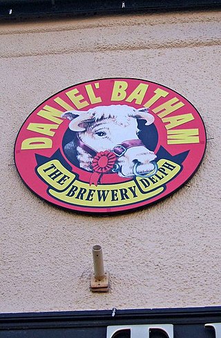
Bathams is a brewery in Brierley Hill, West Midlands, England established in 1877 in a former slaughterhouse. The brewery is described by the CAMRA Good Beer Guide as "A classic Black country small brewery". It produces three cask conditioned beers, Best Bitter (4.3%), Mild (3.5%) and XXX (6.3%), a Christmas special. The Best Bitter won its highly contested class at the Great British Beer Festival in 1991. Bottled versions are also available at Bathams pubs.

This article details a number of defunct schools that were once located in the Metropolitan Borough of Dudley. For details of currently operating schools in the area, please see: List of schools in Dudley.

Norton is a suburb and council ward in the town of Stourbridge, West Midlands. It has a population of 11,943 in an area of 569 hectares. The population is largely White British and self-identifies as predominantly Christian.

References

  1. "Dudley Ward population 2011" . Retrieved 18 December 2015.
  2. "Wollaston :: Survey of English Place-Names". epns.nottingham.ac.uk. Retrieved 21 March 2024.
  3. "Search results for Wollaston". discovery.nationalarchives.gov.uk. Retrieved 21 March 2024.
  4. 1 2 3 4 5 6 7 8 9 10 11 12 13 A History of Wollaston. History of Wollaston Group. 2004. ISBN   0954705300.
  5. "A History of the County of Worcester: Volume 3 - Parishes: Old Swinford". www.british-history.ac.uk. British History Online. London: Victoria County History. 1913. pp. 213–223. Retrieved 21 March 2024.{{cite web}}: CS1 maint: others (link)
  6. "History of Wollaston website".
  7. Haden, H Jack (1988). Street names of Stourbridge & its vicinity. The Dulston Press. pp. 99, 199.
  8. Express and Star "Festive Lights Switched Off" article - 25 October 2006
  9. The Unicorn Inn, History of Wollaston, retrieved 26 February 2019
  10. "Tell me about my neighbourhood". maps.dudley.gov.uk. Retrieved 5 April 2024.
  11. "The Ridge Primary School - Home". theridge.sch.life. Retrieved 21 March 2024.
  12. "St James's C of E Primary School: To our wonderful school". www.st-james.dudley.sch.uk. Retrieved 21 March 2024.
  13. The Builder. London. 5 May 1860. p. 284.{{cite book}}: CS1 maint: location missing publisher (link)
  14. Historic England. "Church of St James, Bridnorth Road (1076048)". National Heritage List for England .
  15. Historic England. "Railings and Gatepiers in front of the Church of St James... (1076049)". National Heritage List for England .
  16. Historic England. "Vicarage to the Church of St James, Bridnorth Road (1262891)". National Heritage List for England .