In early 2021, there were just under 9,800 unique Conservation Areas in England (excluding sub-sections managed by secondary Local Planning Authorities), providing heritage protection for around 2.3% of England's land area and over 10% of properties. This article was originally intended to provide a comprehensive list, arranged by ceremonial county and district / unitary authority, but the listing has remained incomplete (currently around 10% including external links) and has only been sporadically added to or maintained. The table has been retained at the foot of this article, as it provides a holding structure for a number of useful local links, but its usefulness has been largely superseded by other sources.
In mid-2017, the first comprehensive listing was published, accompanied by a range of supporting analysis, and made available as a PDF download or in spreadsheet format by the author. This has subsequently been improved on by a new national spatial dataset, containing not only the names and key attributes of all English conservation areas, but also a full boundary dataset suitable for use in spatial analysis. [1] This is currently the best available summary of English conservation areas, but will gradually become outdated as Local Planning Authorities designate new areas or amend the spatial extent of existing areas.
There is marked variation in the use of conservation area status across England, with coverage ranging from 100% of properties in the Isles of Scilly (which is one large conservation area) through an average of 17% in London (although some boroughs have over 50% coverage) to under 5% in about 30% of local authority areas. In some areas, the listing of individual buildings plays a very prominent role in local heritage protection, but in London almost 40 times as many properties benefit from conservation area protections, and in some areas such as Blackpool, Watford, Oadby, Wigston and Eastbourne the ratio is over 50.
An official national spatial dataset for English conservation areas is maintained by Historic England, which makes copies available on request, although 4% of Local Planning Authorities are omitted and a further 20% have not currently granted permission to publish their data.[ citation needed ]
Buckinghamshire is a ceremonial county in South East England and one of the home counties. It is bordered by Northamptonshire to the north, Bedfordshire to the north-east, Hertfordshire to the east, Greater London to the south-east, Berkshire to the south, and Oxfordshire to the west. The largest settlement is the city of Milton Keynes, and the county town is Aylesbury.

Greater Manchester is a ceremonial county in North West England. It borders Lancashire to the north, Derbyshire and West Yorkshire to the east, Cheshire to the south, and Merseyside to the west. Its largest settlement is the city of Manchester.

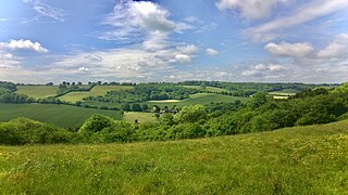
The Chiltern Hills or the Chilterns are a chalk escarpment in southern England, northwest of London, covering 660 square miles (1,700 km2) across Oxfordshire, Buckinghamshire, Hertfordshire, and Bedfordshire, stretching 45 miles (72 km) from Goring-on-Thames in the southwest to Hitchin in the northeast. The hills are 12 miles (19 km) at their widest.

Trafford is a metropolitan borough of Greater Manchester, England, with an estimated population of 236,301 in 2022. It covers 106 square kilometres (41 sq mi) and includes the area of Old Trafford and the towns of Altrincham, Stretford, Urmston, Partington and Sale. The borough was formed in 1974 as a merger of six former districts and part of a seventh. The River Mersey flows through the borough, separating North Trafford from South Trafford, and the historic counties of Lancashire and Cheshire. Trafford is the seventh-most populous district in Greater Manchester.

The London metropolitan area is the metropolitan area of London, England. It has several definitions, including the London Travel to Work Area, and usually consists of the London urban area, settlements that share London's infrastructure, and places from which it is practicable to commute to work in London. It is also known as the London commuter belt, or Southeast metropolitan area.
Chiltern District was a local government district of Buckinghamshire in south-central England from 1974 to 2020. It was named after the Chiltern Hills on which the region sits.

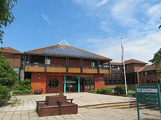
Salford, also known as the City of Salford, is a metropolitan borough with city status in Greater Manchester, England. The borough is named after its main settlement, Salford, but covers a larger area which includes the towns of Eccles, Swinton, Walkden and Pendlebury. The borough had a population of 278,064 in 2022, and is administered from the Salford Civic Centre in Swinton.

Eccles is a market town in the City of Salford in Greater Manchester, England, 3 miles (4.8 km) west of Salford and 4 miles (6.4 km) west of Manchester, split by the M602 motorway and bordered by the Manchester Ship Canal to the south. The town is famous for the Eccles cake.

Aspley Guise is a village and civil parish in the west of Central Bedfordshire, England. In addition to the village of Aspley Guise itself, the civil parish also includes part of the town of Woburn Sands, the rest of which is in the City of Milton Keynes in Buckinghamshire. Together with Woburn Sands and Aspley Heath, it forms part of the Milton Keynes urban area. It is centred 6 miles (9.7 km) east southeast of Central Milton Keynes and 1 mile (1.6 km) south of the M1 junction 13. It has its own railway station on the Marston Vale Line, and an historic centre with 29 listed buildings.
In January 2004, Deputy Prime Minister John Prescott announced the United Kingdom government's Expansion plans for Milton Keynes. However, the change of government in 2010 and the abolition of the Regional Spatial Strategy in 2012/13 saw these plans revoked and a planned expansion of up to 44,000 dwellings reduced to 28,000. The Milton Keynes Core Strategy was published in July 2013 and regards the figure of 28,000 new homes to be the minimum figure.

MediaCityUK is a 200-acre (81 ha) mixed-use property development on the banks of the Manchester Ship Canal in Salford, Greater Manchester, England. The project was developed by Peel Media; its principal tenants are media organisations and the Quayside MediaCityUK shopping centre. The land occupied by the development was part of the Port of Manchester and Manchester docks.
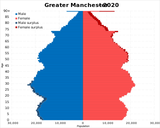
The demography of Greater Manchester is analysed by the Office for National Statistics and data is produced for each of its ten metropolitan boroughs, each of the Greater Manchester electoral wards, the NUTS3 statistical sub-regions, each of the Parliamentary constituencies in Greater Manchester, the 15 civil parishes in Greater Manchester, and for all of Greater Manchester as a whole; the latter of which had a population of 2,682,500 at the 2011 UK census. Additionally, data is produced for the Greater Manchester Urban Area. Statistical information is produced about the size and geographical breakdown of the population, the number of people entering and leaving country and the number of people in each demographic subgroup.

Kings and Bakers Woods and Heaths is a 212.8-hectare (526-acre) Site of Special Scientific Interest (SSSI) between Heath and Reach in Bedfordshire and Great Brickhill in Buckinghamshire. The site is mainly in Bedfordshire but includes Rammamere Heath in Buckinghamshire. It was notified in 1984 under Section 28 of the Wildlife and Countryside Act 1981, and the local planning authorities are Central Bedfordshire Council and Aylesbury Vale Council. Part of it is a National Nature Reserve, and part of it is a nature reserve managed by the Wildlife Trust for Bedfordshire, Cambridgeshire and Northamptonshire. it is also a Nature Conservation Review site.
In the United Kingdom, the term conservation area almost always applies to an area of special architectural or historic interest, the character of which is considered worthy of preservation or enhancement. It creates a precautionary approach to the loss or alteration of buildings and/or trees, thus it has some of the legislative and policy characteristics of listed buildings and tree preservation orders. The concept was introduced in 1967, and by 2017 almost 9,800 had been designated in England.

Barton Road Swing Bridge is a swing bridge for road traffic in Greater Manchester that crosses the Manchester Ship Canal between Trafford Park in the Metropolitan Borough of Trafford to Barton-upon-Irwell in the City of Salford. The bridge is a Grade II* listed building, and is part of a surrounding conservation area. It runs parallel to the Barton Swing Aqueduct which carries the Bridgewater Canal. The bridge opens regularly for traffic along the Manchester Ship Canal, which can cause delays for road traffic.

The Trafford Centre is a tram stop on the Manchester Metrolink's Trafford Park Line, and the line's current terminus. It is located adjacent to Barton Dock Road between Ellesmere Circle and Bright Circle, and serves the like-named shopping centre.

There are 48 Grade I listed buildings in Greater Manchester, England. In the United Kingdom, the term listed building refers to a building or other structure officially designated as being of special architectural, historical or cultural significance; Grade I structures are those considered to be "buildings of exceptional interest". In England, the authority for listing under the Planning Act 1990 rests with Historic England, a non-departmental public body sponsored by the Department for Culture, Media and Sport.
Notes
Sources