Purfleet

Last updated

Purfleet-on-Thames
Gateway-Clocktower at Purfleet - geograph.org.uk - 323278.jpg
Gateway Clocktower
Essex UK location map.svg
Red pog.svg
Purfleet-on-Thames
Location within Essex
OS grid reference TQ555775
Unitary authority
Ceremonial county
Region
Country England
Sovereign state United Kingdom
Post town PURFLEET
Postcode district RM19
Dialling code 01708
Police Essex
Fire Essex
Ambulance East of England
UK Parliament
List of places
UK
England
Essex
51°28′48″N0°15′00″E / 51.480°N 0.250°E / 51.480; 0.250

Purfleet-on-Thames is a town in the Thurrock unitary authority, Essex, England.

Contents

It is bordered by the A13 road to the north and the River Thames to the south and is within the easternmost part of the M25 motorway but just outside the Greater London boundary. It was within the traditional Church of England parish of West Thurrock. Some industry is located to the south and the area forms part of the Thames Gateway redevelopment area. Purfleet is one of seven conservation areas in Thurrock. [1]

History

The place-name "Purfleet" is first attested in 1285, where it appears as Purteflyete. It is recorded as Pourteflet in the Close Roll for 1312. The name means "Purta's stream or tidal inlet". [2]

In the 18th century, Purfleet Royal Gunpowder Magazine was established as a location for the storage of gunpowder together with a garrison to protect it. A constant danger of explosion as a result of lightning strikes existed. Benjamin Franklin was asked for advice on the design of a lightning conductor and a committee of the Royal Society supported his design for pointed conductors. After the American Revolution the powder store was protected from lightning which hit the building, though metal drainpipes actually did the work. When King George III heard of this, he insisted they be replaced with blunt conductors and the president of the Royal Society was forced to resign. [3] [4]

Magazine number 5, the only one remaining of the original five, is now the Purfleet Garrison Heritage and Military Centre and a Scheduled Ancient Monument. It is run by volunteers and contains a wide range of local and military memorabilia (including items from RAF Hornchurch) and is open to the public on Thursdays, Sundays and bank holidays.

J. M. W. Turner (1775–1851) made sketches of Purfleet in 1805-08 mainly featuring the Powder Magazines. The sketches are collected in the River and Margate Sketchbook which are part of the Tate Britain collection and accepted as part of the Turner Bequest in 1856. [5]

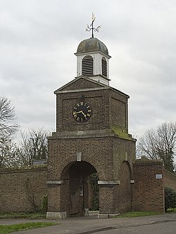
Other surviving 18th-century buildings include the proofing house (now used for community activities) and the gatehouse clock tower (described by English Heritage as forming "an integral part of the finest ensemble in any of the Ordnance Yards, consistent with the high standards practised by the Ordnance Board in its designs for fortifications and barracks from the C17"). [6]

In his history of Essex (1848) [7] W. White describes Purfleet as having 704 inhabitants including 199 from the barracks. "Purfleet is a village and military station...at the mouth of a rivulet, and at the west end of West Thurrock ... sometimes called a township ... and has a pleasure fair on the 13th of June. Near it are the extensive limeade chalk pits of W.H. Whitbread, the lord of the manor. The harbour is often full of shipping business and animation: and joining it is a large government powder magazine, consisting of five detached bomb-proof and well-protected store-houses, barracks for a company of artillery, a store keeper's mansion, and a good quay. The magazine was built in 1781, and has room for the safe keeping of 60,000 barrels of gunpowder." [8]

In March 1916, anti-aircraft gunners based at Purfleet shot down the German Zeppelin LZ 48 (also listed as L15) — the first airship to be destroyed by anti-aircraft artillery. In recognition of their achievement, the gunners received a prize from the Lord Mayor of London, Sir Christopher Wakefield. [9]

From 1921 to 1936, Purfleet formed an urban district of Essex, including the parishes of Aveley, West Thurrock and South Ockendon. It covered an area of 8,900 acres (3,600 ha) and in 1931 had a population of 8,511. The parishes and urban district were abolished in 1936 and their former area was used to form part of Thurrock Urban District.

Reflecting its importance as a seaport and storage depot, Purfleet was listed by the Ministry of Food as one of 14 sensitive A-bomb targets in 1955, including an entrepot for the import of tea. [10]

In Bram Stoker's novel Dracula , first published in 1897, Count Dracula purchased the fictional house called "Carfax" in Purfleet, which was next to a lunatic asylum. [11]

In 2020, after a two-year campaign, the town's name was officially changed to Purfleet-on-Thames in an attempt to improve its fortunes and attract more investment. [12]

High House Production Park

In 2006 Thurrock Thames Gateway Development Corporation initiated a project to regenerate High House, Purfleet by renovating historic farm buildings dating from the 16th century and encouraging the development of some creative-industry buildings on the 14-acre site.

The Royal Opera House's Bob and Tamar Manoukian scene-making facility for its operas and ballets opened on the High House site in December 2010, followed by a Costume Centre in 2015. Creative & Cultural Skills opened The Backstage Centre at the park in March 2013. [13] The Backstage Centre now houses the national headquarters of Creative & Cultural Skills. [14] In July 2013 ACME Studios, opened 43 artist studios in the park. [15]

Industry

Purfleet has been the site of a Unilever (formerly Van den Berghs & Jurgens) factory producing Stork, Flora, Bertolli, and ICBINB! margarine since 1917, reputed to be the largest in the world.[ citation needed ] It is the location of an Esso lubricants plant, a roll-on/roll-off ferry (RORO) terminal, and the head office of Carpetright, the UK's largest flooring company. It is also home to Scania GB Ltd's largest European workshop/office. [16]

Nearest places

Transport

Road transport links connect Purfleet to nearby towns including Basildon and Grays, as well as Lakeside Shopping Centre with buses operated by Ensignbus and NIBS Buses. Railway services operated by c2c from Purfleet station offer frequent services to London Fenchurch Street, Barking, Grays, Tilbury and Southend. The town is also one of the termini of the London LOOP long-distance trail.

Purfleet Freight Terminal

Purfleet Freight Terminal is the closest Roll-on/Roll-off (RORO) ferry port to London. Operated by C.RO Ports, the 92-acre (37 ha) combined freight terminal handles 250,000 lorry trailers and ISO containers and tanks per year, and via a dedicated Pre-Delivery Inspection (PDI) facility, the import/export of 400,000 vehicles. There are four railway sidings on site, accessed via the London, Tilbury and Southend line to allow direct unloading/loading from ferry or lorry to rail. Scheduled ferry services are operated daily by sister-company Cobelfret Ferries to the Port of Zeebrugge, Belgium and the Port of Rotterdam, Netherlands. [17] [18]

Media

The town is served by BBC London and ITV London with television signals received from Crystal Palace TV transmitter, [19] BBC South East and ITV Meridian can also be received from Bluebell Hill TV transmitter. [20]

Local radio stations are BBC Essex, Heart Essex, Radio Essex and Gateway 97.8, a community based radio station. [21]

The Thurrock Gazette is the town's local weekly newspaper. [22]

Sport

Thurrock F.C. (formerly Purfleet F.C.) played in the town until disbanding in 2018, and the local council helps to maintain seven leisure centres and one country club in the Borough, the nearest centre being in Springhouse Road, Corringham. [23] The Circus Tavern in Purfleet was the venue of the PDC World Darts Championship between 1994 and 2007, as well as hosting the Players Championship Finals in 2009 & 2010. [24] [25]

Related Research Articles

<span class="mw-page-title-main">Thurrock</span> Borough in Essex, England

Thurrock is a unitary authority area with borough status in the ceremonial county of Essex, England. It lies on the north bank of the River Thames immediately east of London and has over 18 miles (29 km) of riverfront including the Port of Tilbury, the principal port for London. Thurrock is within the London commuter belt and is an area of regeneration within the Thames Gateway redevelopment zone. The borough includes the northern ends of the Dartford Crossing.

The Port of London is that part of the River Thames in England lying between Teddington Lock and the defined boundary with the North Sea and including any associated docks. Once the largest port in the world, it was the United Kingdom's largest port as of 2020. Usage is largely governed by the Port of London Authority ("PLA"), a public trust established in 1908; while mainly responsible for coordination and enforcement of activities it also has some minor operations of its own.

<span class="mw-page-title-main">Grays, Essex</span> Town in Essex, England

Grays is the largest town in the borough and unitary authority area of Thurrock, in the ceremonial county of Essex, England. The town, which is both a former civil parish and one of Thurrock's traditional Church of England parishes, is located on the north bank of the River Thames.

<span class="mw-page-title-main">A13 road (England)</span> Major road in England

The A13 is a major road in England linking Central London with east London and south Essex. Its route is similar to that of the London, Tilbury and Southend line via Rainham, Grays, Tilbury, Stanford-Le-Hope & Pitsea,and runs the entire length of the northern Thames Gateway area, terminating on the Thames Estuary at Shoeburyness. It is a trunk road between London and the Tilbury junction, a primary route between there and Sadlers Hall Farm near South Benfleet, and a non-primary route between there and Shoeburyness.

<span class="mw-page-title-main">Tilbury</span> Human settlement in England

Tilbury is a port town in the borough of Thurrock, Essex, England. The present town was established as separate settlement in the late 19th century, on land that was mainly part of Chadwell St Mary. It contains a 16th century fort and an ancient cross-river ferry. Tilbury is part of the Port of London with a major deep-water port which contributes to the local economy. Situated 24 miles (38.5 km) east of central London and 23 miles (37 km) southwest of Southend-on-Sea, it is also the southernmost point in Essex.

<span class="mw-page-title-main">Aveley</span> Human settlement in England

Aveley is a town and former civil parish in the unitary authority of Thurrock in Essex, England, and forms one of the traditional Church of England parishes. Aveley is 16 miles (26.2 km) east of Charing Cross. In the 2021 United Kingdom census it had a population of 9,801.

<span class="mw-page-title-main">South Ockendon</span> Human settlement in England

South Ockendon is a town, former civil parish and Church of England parish within the Thurrock borough in Essex in the East of England, United Kingdom. It is located on the border with Greater London, just outside the M25 motorway. The area to the north is North Ockendon. In 2019 it had an estimated population of 22,303 and in the 2021 United Kingdom census it had a population of 22,442

<span class="mw-page-title-main">Wennington, London</span> Human settlement in England

Wennington is a small village in the London Borough of Havering, in east London. It is situated 14.8 miles (23.8 km) east of Charing Cross. Wennington was an ancient parish in the county of Essex that was abolished for civil purposes in 1934. It is peripheral to London, forming a ribbon development extending from the eastern edge of the urban sprawl and surrounded by the Metropolitan Green Belt. Wennington was added to Hornchurch Urban District in 1934 and has formed part of Greater London since 1965.

<span class="mw-page-title-main">West Thurrock</span> Human settlement in England

West Thurrock is an area, former civil parish and traditional Church of England parish in Thurrock, Essex, England, located 18 miles (28.1 km) east south-east of Charing Cross, London. In 1931 the parish had a population of 5,153. On 1 April 1936, the parish was abolished to form Thurrock.

<span class="mw-page-title-main">Thurrock (UK Parliament constituency)</span> Parliamentary constituency in the United Kingdom, 1945 onwards

Thurrock is a constituency represented in the House of Commons of the UK Parliament since 2010 by Jackie Doyle-Price, a Conservative.

<span class="mw-page-title-main">Stanford-le-Hope</span> Human settlement in England

Stanford-le-Hope is a town, former civil parish and Church of England parish in the unitary authority area of Thurrock, in the ceremonial county of Essex, England. Often known locally simply as Stanford, the town is located 24 miles (38.4 km) east of Charing Cross in London. In 2011 it had a population of 28,765.

<span class="mw-page-title-main">Thames Chase</span>

The Thames Chase Community Forest is a community forest of 9842 hectares located in 47 sites in London and Essex, England. Administered by the Thames Chase Trust, the community forest's stated aim is "to renew and regenerate the landscape at the edge of East London and South Essex by creating a varied wooded landscape for local people to influence, create, use, enjoy and cherish".

<span class="mw-page-title-main">Rainham Marshes Nature Reserve</span> Marshland nature reserve in east London

Rainham Marshes is an RSPB nature reserve in the east of London, adjacent to the Thames Estuary in Purfleet, Thurrock and the London Borough of Havering.

Thurrock Thames Gateway Development Corporation was a non-departmental public body sponsored by the Department for Communities and Local Government. It was an Urban Development Corporation set up by the Government of the United Kingdom covering the entire borough and unitary authority of Thurrock in Essex. It handled large planning applications in the borough, and was part of the government's plan for urban expansion in the Thames Gateway.

Orsett Rural District was the local government district centred on Orsett in south Essex, England from 1894 to 1936; a little of its far west is in modern Greater London. Likewise in modern terms the area is mostly east of the M25 motorway and north of the Thames Estuary. It was formed in 1894. Housing quite a few residents, it gradually fell from 62.4 to 49.6 square miles. Its notable omission was Grays or Great Thurrock; Thurrock was the main successor district.

<span class="mw-page-title-main">Gunpowder magazine</span> Building used to store gunpowder

A gunpowder magazine is a magazine (building) designed to store the explosive gunpowder in wooden barrels for safety. Gunpowder, until superseded, was a universal explosive used in the military and for civil engineering: both applications required storage magazines. Most magazines were purely functional and tended to be in remote and secure locations. They are the successor to the earlier powder towers and powder houses.

<span class="mw-page-title-main">High House, Purfleet</span>

High House is the collective name for a group of historic buildings in Purfleet, Thurrock, Essex, which was used as a farm for hundreds of years, with a Grade II listed house and barn, but with the addition of one of the best dovecotes in Southern England, which is a Scheduled Ancient Monument and notable for its nest box array. This property includes the house, coachman's cottage, chaise house, stable, granary, barn, workshop, cart sheds, dovecote, and inner and outer walled gardens. Known by many names in its past, the farm has been called Le Vineyards, because grape vines were grown on one of its south facing slopes. Its current name comes from the fact that it is a house high on the hill, which commands great views over the River Thames.

<span class="mw-page-title-main">Mardyke (river)</span> River in Essex, England

The Mardyke is a small river, mainly in Thurrock, that flows into the River Thames at Purfleet, close to the Queen Elizabeth II Bridge. In part, it forms the boundary between the Essex hundreds of Barstable and Chafford. The river gives its name to the Mardyke Valley—a project aimed at increasing appreciation and usage of recreational land around the Mardyke.

<span class="mw-page-title-main">Thurrock Council</span> Local authority in England

Thurrock Council is the local authority for the borough of Thurrock in the ceremonial county of Essex, England. Thurrock is a unitary authority, having the powers and functions of a county council and district council combined. It is a member of the East of England Local Government Association. The council is based in Grays.

References

  1. "Conservation Areas in Thurrock". thurrock.gov.uk. Thurrock Council. Retrieved 16 August 2017.
  2. Eilert Ekwall, The Concise Oxford Dictionary of English Place-names, pp.375 and 182.
  3. Van Doren, Carl (1939). Benjamin Franklin. London: Putnam. pp.  429.
  4. Christopher Harrold (editor) Exploring Thurrock (Thurrock Local History Society, 2008)
  5. Tate website
  6. listed building description
  7. History, gazetteer and directory of Essex, 1848
  8. Quoted in Brian Evans (2004), Grays Thurrock, A History, Phillimore
  9. Thurrock Council | Thurrock Heritage | Parish Facts Archived 8 June 2011 at the Wayback Machine
  10. BBC NEWS | UK | Nuclear threat sparked tea worry
  11. Bram: Dracula, Chapter 2, 1897 ISBN   978-0141439846
  12. Scotter, Kate; Shepka, Phil (7 July 2020). "Why this Essex town decided to change its name". BBC News. Retrieved 8 July 2020.
  13. "Home - The Backstage Centre".
  14. "Creative & Cultural Skills".
  15. "Acme Studios - High House Artists' Studios". Archived from the original on 8 August 2014. Retrieved 21 September 2013.
  16. Financial Times, 16 December 2015
  17. "C.RO - Ports - Stevedoring - Services".
  18. "Ports.org.uk / Purfleet".
  19. "Full Freeview on the Crystal Palace (Greater London, England) transmitter". UK Free TV. 1 May 2004. Retrieved 4 December 2023.
  20. "Full Freeview on the Bluebell Hill (Medway, England) transmitter". UK Free TV. 1 May 2004. Retrieved 4 December 2023.
  21. "Gateway 97.8" . Retrieved 4 December 2023.
  22. "Thurrock Gazette". British Papers. 11 November 2013. Retrieved 4 December 2023.
  23. Tourism Dept – Leisure Facilities Archived 4 October 2013 at the Wayback Machine Thurrock B.C Retrieved 23 July 2013
  24. "BBC SPORT | Other Sport... | Darts | PDC championship moves to London".
  25. "PDC Return to Circus Tavern | Planet Darts | Latest News | Latest News | Latest News". www.planetdarts.tv. Archived from the original on 4 November 2008. Retrieved 12 January 2022.