It has historically been a primarily agricultural community situated at the southern edge of the old ice age flood plain traversed by the river Mardyke.
Orsett contains a ring and bailey earthwork known locally as Bishop Bonner's palace; so called as it was the residence of the Bishops of London, including Bishop Edmund Bonner from 1553 to 1559.[2] On the gravel terrace, there is a neolithic causewayed enclosure discovered as a result of crop marks which showed on aerial photographs taken by St Joseph of Cambridge University.[3] It has three concentric ditches with a number of breaks or causeways. The enclosure was used as a burial ground by the Saxons and contained at least three barrows visible on the aerial photo.[4]
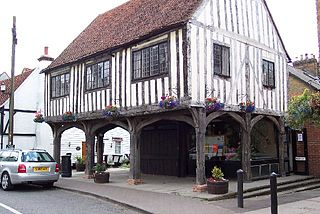
On the junction of Pound Lane and High Road is the village lock-up, removed in the mid 19th century but restored in the mid 20th century, the lockup or cage was built in the late 17th or early 18th century. It has barred windows and a plank door with heavy hinges. Before a national system of policing was set up many villages had their own lock-up. Petty criminals were held for a short time before being released or sent to a larger town for trial.[5]
Orsett Heath in the south of the parish was formerly part of an extensive area of heathland that included Terrel's Heath.
In 1931 the parish had a population of 1771.[6] On 1 April 1936 the parish was abolished to form Thurrock.[7]
Geography
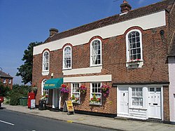
The centre of Orsett is aligned on an east–west axis along the High Road, on which is the parish church of St Giles and All Saints along with the animal pound and lock-up opposite Rowley Road. Its former workhouse on Rowley Road was developed into a large modern hospital in the 1960s but has, since the 1980s, been reduced in size once again. Most of the former shops in the High Road, including the Post Office opposite the Church and the blacksmith's in Rowley Road, have closed to be replaced by just one convenience store which contains a sub post office.[8]
Two public houses have survived in the centre of the village, one being the prize-winning Whitmore Arms, the other the Foxhound, and outside the village centre Orsett has one additional pub – The Kings Arms.
Education
The village's primary school has been located since the mid-19th century in School Lane, educating children up to the age of 14 until 1944 and to 11 thereafter.
Buildings
The Old Bakery on east side of Rectory Road
Orsett has a variety of listed and interesting buildings, including the almost perfectly preserved Victorian workmen's cottages on Maltings Lane[9] as well as several Grade Two listed timber-framed and thatched houses, and grand houses dating from the reign of Charles II.
Apart from some small-scale Council housing in Ridgewell Avenue to the North of the High Street, there was no significant growth in residential development until 1954–55 when new properties were erected in School Lane. These were followed by further developments on the former site of the Anglican Rectory (known as Herga Hyll following its sale), off Rectory and Conways Roads and off Rowley Road. During the late 1980s and throughout the 1990s, a new housing estate was built on land that belonged to the old container site, and some of the ex-military Orsett Camp site, between Stanford Road and Orsett Golf Course.
Most of the former hospital site has been re-developed as housing in the last five years. The redevelopment provided 200 houses, despite being within the green belt and avoided the need to provide affordable housing on the site.[10]
Opposite the Old Bakery, on the west side of Rectory Road, is Orsett Masonic Hall which is home to Orsett Masonic Lodge.
The historic Orsett Hall on Prince Charles's Avenue, the home of the Whitmore family until their estate was sold in the late-1960s, was destroyed by fire in May 2007 but was rebuilt during 2008–09.[11] The exterior design is in keeping with the original Georgian building. It was used for a Help for Heroes charity event on 11 April 2010. Orsett House is an early-eighteenth-century house off the High Street and on the western edge of the village.
It has a well-equipped village hall at its western end and a centre for the churches in the High Street.
Sport
Orsett is home to a cricket club. It has one tennis court and a bowling green.
Thurrock is a unitary authority area with borough status in the ceremonial county of Essex, England. It lies on the north bank of the River Thames immediately east of London and has over 18 miles (29 km) of riverfront including the Port of Tilbury, the principal port for London. Thurrock is within the London commuter belt and is an area of regeneration within the Thames Gateway redevelopment zone. The borough includes the northern ends of the Dartford Crossing.
Grays is the largest town in the borough and unitary authority area of Thurrock, in the ceremonial county of Essex, England. The town, which is both a former civil parish and one of Thurrock's traditional Church of England parishes, is located on the north bank of the River Thames.
Severn Beach is a village on the Severn Estuary in South Gloucestershire, England. The eastern portal of the Severn Tunnel is on the outskirts of the village. The Severn footpath – on the sea wall – is part of the Severn Way that leads from Gloucester, Slimbridge and the Second Severn Crossing. Extensive sea defences have been constructed and this provides a popular walkway along its length. Originally, the Severn Way finished at Severn Beach, but it has been extended to Bristol.
Chafford Hundred is an area in the Borough of Thurrock in the ceremonial county of Essex, England. Chafford Hundred is north-west of Grays.
Aveley is a town and former civil parish in the unitary authority of Thurrock in Essex, England, and forms one of the traditional Church of England parishes. Aveley is 16 miles (26.2 km) east of Charing Cross. In the 2021 United Kingdom census it had a population of 9,801.
West Horndon is a village and civil parish in the south of the Borough of Brentwood, Essex on the boundary with Thurrock. It is located 5 miles east of Upminster in the London Borough of Havering, East London and 20 miles (32 km) east north-east of Charing Cross in Central London. The civil parish also includes East Horndon and Dunton Hills.
Bulphan is a village and former civil parish in the borough of Thurrock in Essex and one of the traditional parishes in Thurrock. In 2019 it had an estimated population of 1028.
Chadwell St Mary is an area of the unitary authority of Thurrock in Essex, England. It is one of the traditional parishes in Thurrock and a former civil parish. Grays is 2 miles (3.2 km) to the west and 1 mile (1.6 km) to the south is Tilbury. The area is sometimes referred to simply as Chadwell, particularly before the 19th century.
West Tilbury is a village and former civil parish in the Thurrock district, in the ceremonial county of Essex, England. It is on the top of and on the sides of a 30 metres (98 ft) tall river terrace overlooking the River Thames. Part of the modern town of Tilbury is within the traditional parish of West Tilbury. In 1931 the parish had a population of 444. On 1 April 1936 the parish was abolished to form Thurrock.
East Tilbury is a village and former civil parish in the unitary authority of Thurrock borough, Essex, England, and one of the traditional Church of England parishes in Thurrock. In 2011 the ward had a population of 6,363.
Corringham is a town and former civil parish in the unitary authority area of Thurrock, in the ceremonial county of Essex, England, located directly next to the town of Stanford-le-Hope, about 24 miles (39 km) east of London and 3 miles (4.8 km) south of Basildon. Corringham lies on a hill overlooking the Thames between Canvey Island and Tilbury Fort. It is 6 miles (9.7 km) north-east of Grays, the administrative centre of Thurrock.
Orsett Hall was a 17th-century Grade II listed building in Orsett, Essex. It was set in 12 acres (4.9 ha) of parkland and was the centre of the Orsett Hall agricultural estate. The house was destroyed by fire on 11 May 2007 and rebuilt in the same style and on the same footprint as the original building in 2009.
Colonel Sir Francis Henry Douglas Charlton Whitmore, 1st Baronet was a British military officer and landowner.
Horndon on the Hill is a village, former civil parish and Church of England parish in the unitary authority of Thurrock, in the county of Essex, England. It is located close to the A13, around one mile northwest of Stanford-le-Hope and around two miles northeast of Orsett. The village area falls within the Orsett ward of Thurrock District Council. In 2019 it had an estimated population of 1517.
Little Thurrock is an area, ward, former civil parish and Church of England parish in the town of Grays, in the unitary authority of Thurrock, Essex. In 1931 the parish had a population of 4428.
Little Burstead is a village in Essex, England. It lies 2.25 miles (4 km) south-south-west of Billericay and 4.5 miles (7 km) east-south-east of Brentwood railway station.
Terrel's Heath is, in spite of its name, an area of woodland in Chadwell St Mary named on the 1938 six-inch Ordnance Survey map.
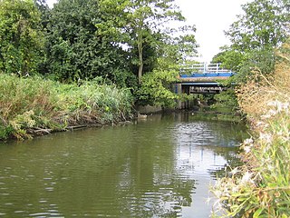
The Mardyke is a small river, mainly in Thurrock, that flows into the River Thames at Purfleet, close to the Queen Elizabeth II Bridge. In part, it forms the boundary between the Essex hundreds of Barstable and Chafford. The river gives its name to the Mardyke Valley—a project aimed at increasing appreciation and usage of recreational land around the Mardyke.
Thurrock Council is the local authority for the borough of Thurrock in the ceremonial county of Essex, England. Thurrock is a unitary authority, having the powers and functions of a county council and district council combined. It is a member of the East of England Local Government Association. The council is based in Grays.
This page is based on this Wikipedia article Text is available under the CC BY-SA 4.0 license; additional terms may apply. Images, videos and audio are available under their respective licenses.