
Bedford is a market town in Bedfordshire, England. At the 2011 Census, the population of its urban area, including Kempston and Biddenham, was 106,940. Bedford is also the county town of Bedfordshire and seat of the Borough of Bedford, a unitary authority that includes a significant rural area.

Flitwick is a town and civil parish in Central Bedfordshire, England. It is mentioned in the Domesday Book of 1086 as "a hamlet on the River Flitt". The spelling Flytwyk appears in 1381.
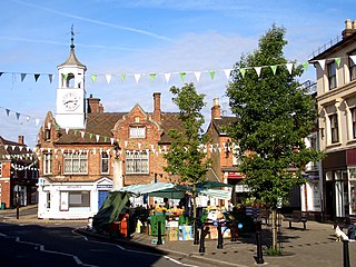
Ampthill is a town and civil parish in the Central Bedfordshire district of Bedfordshire, England. It lies between Bedford and Luton. At the 2021 census it had a population of 8,825.

The Borough of Bedford is a unitary authority area with borough status in the ceremonial county of Bedfordshire, England. Its council is based in Bedford, its namesake and principal settlement, which is the county town of Bedfordshire. The Bedford built-up-area is the 71st largest in the United Kingdom and comprises the boundaries of the pre-1974 Bedford Municipal Borough, the town of Kempston and the village of Biddenham, with the BUA surrounded by a rural area with many villages. 75% of the borough's population live in the Bedford Urban Area and the five large villages which surround it, which makes up slightly less than 6% of the total land area of the Borough.

Billington is a civil parish in Bedfordshire about 3 miles (4.8 km) south of Leighton Buzzard and not far from the Buckinghamshire border. There are two settlements: Little Billington and one that is now called Great Billington. At the 2021 census, the parish had a population of 359.

Arlesey is a town and civil parish in the Central Bedfordshire district of Bedfordshire, England. It is near the border with Hertfordshire, about three miles north-west of Letchworth Garden City, four miles north of Hitchin and six miles south of Biggleswade. Arlesey railway station provides services to London, Stevenage and Peterborough. The Domesday Book of 1086 mentions Arlesey. The town's name means the 'island of a man named Aelfric'.

Stewartby is a model village and civil parish in Bedfordshire, England, originally built for the workers of the London Brick Company. The village was designed and built to the plans of the company's architect Mr F W Walker, laid out on 'Garden City' principle, a later and more modern development than such better-known Victorian model villages as Saltaire. Started in 1926, Stewartby is also a later model than Woodlands which was first planned in 1905. The later retirement bungalow development of the 1950s and 1960s with the pavilion community centre in their midst was designed by the neo-Georgian architect Professor Sir Albert Richardson. Today, Stewartby parish also includes Kempston Hardwick.

Battlesden is a hamlet and civil parish in the Central Bedfordshire district of Bedfordshire, England. It is just north of the A5, between Dunstable and Milton Keynes. According to the 2001 census, it had a population of 38. Because of its low electorate, it has a parish meeting rather than a parish council. It is in the civil parish of Milton Bryan.

Caddington is a village and civil parish in the Central Bedfordshire district of Bedfordshire, England.

Brickhill is a civil parish and electoral ward within northern Bedford in Bedfordshire, England.

Silsoe is a village and civil parish in Bedfordshire, England. The village used to be on the main A6 road but a bypass around the village was opened in 1981 at a cost of £1.6m.

Swineshead is a village and civil parish in the Borough of Bedford in the county of Bedfordshire, England.

Northill is a village and civil parish in the Central Bedfordshire district of the county of Bedfordshire, England about 6.5 miles (10 km) southeast of the county town of Bedford.
Dunton is a village and civil parish in the Central Bedfordshire district of the county of Bedfordshire, England; about 12 miles (19 km) east south-east of the county town of Bedford. The civil parish includes the hamlets of Newton and Millow.

Tempsford is a village and civil parish in the Central Bedfordshire district of the county of Bedfordshire, England, about 7 miles (11 km) east north-east of the county town of Bedford.
Wixams is a new town and civil parish located in Bedfordshire, England, which has been under construction since early 2007. It is expected to become the third largest settlement in the Borough of Bedford after Bedford itself and Kempston, and one of the largest new settlements founded in England since the British new towns movement of the first twenty five years after World War II.

Houghton Conquest is a village and civil parish located in the Central Bedfordshire district of Bedfordshire, England. The parish also includes the hamlet of How End.

Harrold is a village, civil parish and electoral ward in Bedfordshire, England, nine miles north-west of Bedford on the north bank of the River Great Ouse, close to the county boundaries of Buckinghamshire and Northamptonshire. An ancient bridge links the village with Carlton with Chellington on the south bank. Immediately to the east of the village is Odell.

Goldington is part of Bedford, Bedfordshire, England. It encompasses much of the historic village and parish of Goldington that was merged with Bedford in 1934, although some parts of the old village are within the neighbouring Newnham ward. It also includes two modern estates that are part of Renhold parish.

Hulcote is a village and a former civil parish, now in the parish of Hulcote and Salford, in the Central Bedfordshire district of the ceremonial county of Bedfordshire, England. In 1931 the parish had a population of 39.


