
Flitwick is a town and civil parish in Bedfordshire, England. It is mentioned in the Domesday Book of 1086 as "a hamlet on the River Flitt". The spelling Flytwyk appears in 1381.

Kempston is a town and civil parish in the Borough of Bedford, Bedfordshire, England, situated around 2 miles (3.2 km) south-west of Bedford town centre. It had a population of 19,330 in the 2011 census, and forms part of the wider Bedford built-up area. The River Great Ouse separates it from the Queen's Park area of Bedford.

Chaldon Herring or East Chaldon is a village and civil parish in the English county of Dorset, about 8 miles (13 km) south-east of the county town of Dorchester. It is sited 2 miles (3.2 km) from the coast in the chalk hills of the South Dorset Downs. The highest point in the area is Chaldon Hill about 1.5 miles (2.4 km) to the south, overlooking the sea. In the 2011 census the civil parish had 59 households and a population of 140.

Haynes is a village and civil parish in Bedfordshire, England, about seven miles (11 km) south of Bedford. It includes the small hamlet of Haynes Church End. It used to be known as Hawnes. North from Haynes is a hamlet named Silver End, then further up is Herrings Green, Cotton End and Shortstown. There is a pub, "The Greyhound", a shop, a post office, a village hall and a Lower School.

A civil parish is a country subdivision, forming the lowest unit of local government in England. There are 125 civil parishes in the ceremonial county of Bedfordshire, most of the county being parished: Luton is completely unparished; Central Bedfordshire is entirely parished. At the 2001 census, there were 312,301 people living in the 125 parishes, which accounted for 55.2 per cent of the county's population.

Wootton is a large village and civil parish located to the southwest of Bedford, in the north of Bedfordshire, England. The parish also includes the hamlets of Hall End, Keeley Green and Wootton Green.

Kempston Rural is a civil parish in the Borough of Bedford in Bedfordshire, England.

Caddington is a village and civil parish in the Central Bedfordshire district of Bedfordshire, England.

Wrenbury-cum-Frith is a village and civil parish in the unitary authority of Cheshire East, and the ceremonial county of Cheshire, England. It lies on the River Weaver, around 8.5 miles south-west of Crewe.
Pulloxhill is a small village and civil parish in Bedfordshire, England 342 ft above sea level with a population of 850 at the 2001 Census, increasing to 985 at the 2011 Census.
Hardingstone is a village in Northamptonshire, England. It is on the southern edge of Northampton, and now forms a suburb of the town. It is about 1 mile (2 km) from the town centre. The Newport Pagnell road separates the village from the nearby village of Wootton, which has also been absorbed into the urban area.

Wilstead is a village and civil parish in Bedfordshire, England, just off the A6 Bedford to Luton road, about five miles south of Bedford town centre, and within the Borough of Bedford. The name of the village has been spelled in many different ways, including Wilshamstead and Wylhamstead. Wilstead is now the usual name of the village, but the civil parish is named Wilshamstead. The council estimated the population of the parish at 2,550 in 2005. Most of the inhabitants live in the main village, but some live in other hamlets and isolated houses.

Eastcotts is an electoral ward within the Borough of Bedford, in the ceremonial county of Bedfordshire, England. It was formerly also a civil parish until its abolition on 1 April 2019, when Cotton End and Shortstown parishes were established.
Renhold is a village and civil parish located on the River Ouse, in the Borough of Bedford, Bedfordshire, England. The parish church is situated some 4 miles (6.5 km) east-north-east of Bedford town centre. The former Bedfordshire County Council estimated the population of Renhold to be 1,800 in 2005, and forecast an increase to 2,320 by 2010.
Shortstown is a village and civil parish on the outskirts of Bedford, on a ridge above the River Great Ouse, originally called Tinkers Hill.
Cotton End is a small village and civil parish on the outskirts of Bedford. It became its own parish as of 1 April 2019, having previously been part of the parish of Eastcotts. Ordnance Survey maps from the 1880s show its name as 'Cardington Cotton End'.
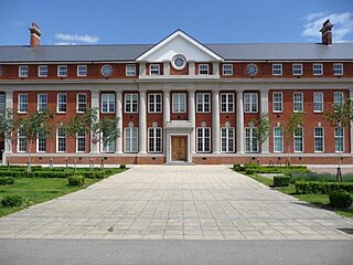
Wixams Academy is a co-educational secondary school and sixth form located in Wixams in the English county of Bedfordshire.
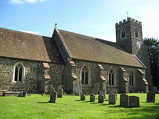
Elstow is a civil parish in Bedford, Bedfordshire, England. It contains 31 listed buildings that are recorded in the National Heritage List for England. Of these, three are listed at Grade I, two are listed at Grade II*, the middle of the three grades, and the others are at Grade II, the lowest grade. The parish adjoins the large town of Bedford. Almost all the listed buildings are houses. Also listed are a church, a moot hall, two public houses and the ruined Hillersdon mansion.
