
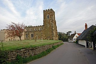
Campton is a village and former civil parish, now in the parish of Campton and Chicksands, in the Central Bedfordshire district of Bedfordshire, England. It is about 9 miles (14 km) south of Bedford, and is about 9 miles (14 km) north-west from Letchworth and sits on a tributary of the River Ivel. It is just to the west of Shefford. The 13th century Church of All Saints is in the centre of the village. In 1961 the parish had a population of 358.

Bletsoe is a village and civil parish in Bedfordshire, England. It is on the A6, and about eight miles north of Bedford. The village has a small park, the former site of Bletsoe Castle and a church. Nearby places are Sharnbrook, Milton Ernest, Riseley, Thurleigh, Odell, Souldrop, and Swineshead. The nearest town to Bletsoe is Bedford.

Carlton is a village and former civil parish, now in the parish of Carlton and Chellington, in the Bedford district, in the ceremonial county of Bedfordshire, England. The River Great Ouse runs just to the north of the village. Nearby places are Chellington, Harrold, Pavenham, Turvey, Lavendon and Odell. In 1931 the parish had a population of 340.

Farndish is a village and former civil parish, now in the parish of Podington, in the Bedford district, in northwest Bedfordshire, England, located about 500 metres (yards) east of the county border with Northamptonshire. The village is near the Northamptonshire villages of Irchester and Wollaston and the Bedfordshire village of Wymington. In 1881 the parish had a population of 72.

Thurgarton is a village and former civil parish, now in the parish of Aldborough and Thurgarton, in the North Norfolk district of the county of Norfolk, England. It lies 6½ miles north of Aylsham and 5½ miles south-west of Cromer, and was once part of the North Erpingham hundred. In 1931 the parish had a population of 186.
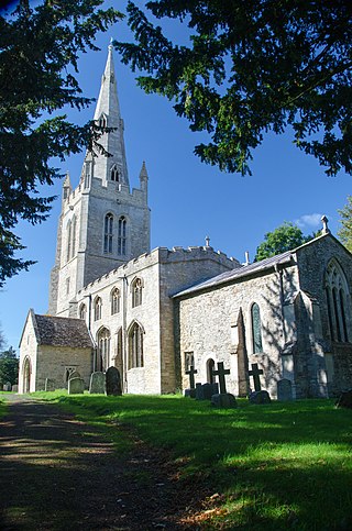
Flitton is a village and former civil parish, now in the parish of Flitton and Greenfield, in the Central Bedfordshire district, in the ceremonial county of Bedfordshire, England. The village derives its name from the River Flit which flows close by it. It is notable primarily as the home of the De Grey Mausoleum adjacent to the St John the Baptist Church. Richard Milward, the editor of Selden's Table Talk, was born at Flitton in 1609. There are two pubs, The White Hart by the church hall and Jolly Coopers at Wardhedges. The annual ‘Gala’ and ‘Potato Race’ are two of the main events that happen in the village. In 1961 the parish had a population of 572. On 1 April 1985 the parish was abolished to form "Flitton & Greenfield", parts also went to Flitwick, Pulloxhill and Westoning.

Souldrop is a village and former civil parish, now in the parish of Knotting and Souldrop, in the Bedford district, in the ceremonial county of Bedfordshire, England, located near the border with Northamptonshire. Nearby places are, Sharnbrook, Podington, Odell, Melchbourne, Yelden, Knotting, and Newton Bromswold and Rushden over the border in Northamptonshire. In 1931 the parish had a population of 161. On 1 April 1934 the parish was abolished and merged with Knotting to form "Knotting and Souldrop".
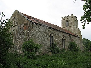
Corpusty is a village and former civil parish, now in the parish of Corpusty and Saxthorpe, in the North Norfolk district, in the county of Norfolk, England, situated on the River Bure. Corpusty is about sixteen miles from Norwich and six miles (10 km) from Holt.
Yelden or Yielden is a village and former civil parish, now in the parish of Melchbourne and Yielden, in the Bedford district, in the ceremonial county of Bedfordshire, England, near the borders with Northamptonshire and Cambridgeshire. It lies on the River Til which feeds into the Great Ouse valley and is about 70 m (230 ft) above sea level. It is approximately 14 miles (23 km) north of Bedford, 3.75 miles (6.04 km) south-east of Higham Ferrers and 6.75 miles (10.86 km) west of Kimbolton and is in the Hundred of Stodden. The countryside around the village rises to about 90 m (300 ft) above sea level, is generally open and rolling in nature and is predominantly used for agricultural purposes. The centre piece of the village is the Castle Mound or Yielden Castle the site of a Norman motte-and-bailey castle. This is now a complex of grassed over earthworks dominated by a central mound. Other notable features include the church of St Mary, a Wesleyan Chapel built in 1884, the Chequers Public House and the Yelden Village Hall. It has a present population of roughly between 150 and 200 adults and between 50 and 100 children living in about 90 residences.

Chellington is a village and former civil parish, now in the parish of Carlton and Chellington, in the Bedford district, in the ceremonial county of Bedfordshire, England, situated approximately 7 miles (11 km) north-west of Bedford town centre. In 1931 the parish had a population of 78.

Higham Gobion is a village and former civil parish, now in the parish of Shillington, in the Central Bedfordshire district, in the ceremonial county of Bedfordshire, England. It is located between the villages of Shillington and Barton-le-Clay. In 1961 the parish had a population of 28. On 1 April 1984 the parish was abolished and merged with Shillington. It was in the hundred of Flitt.

Troutbeck is a village and former civil parish, now in the parish of Lakes, in South Lakeland district in Cumbria, England. It is 3 miles (5 km) north of Windermere town, and west of the A592 road. It is a conservation area and includes the National Trust property of Townend. In 1961 the parish had a population of 592.

Goldington is an area of Bedford and electoral ward in the unparished area of Bedford, in the Bedford district, in the ceremonial county of Bedfordshire, England. It encompasses much of the historic village and parish of Goldington that was merged with Bedford in 1934, although some parts of the old village are within the neighbouring Newnham ward. It also includes two modern estates that are part of Renhold parish.

Hulcote is a village and a former civil parish, now in the parish of Hulcote and Salford, in the Central Bedfordshire district of the ceremonial county of Bedfordshire, England. In 1931 the parish had a population of 39.

Upper Gravenhurst is a village and former civil parish, now in the parish of Gravenhurst, in the Central Bedfordshire district of the ceremonial county of Bedfordshire, England. In 1881 the parish had a population of 354. On 24 March 1888 the parish was abolished and merged with Lower Gravenhurst to form "Gravenhurst".

Salford is a village and former civil parish, now in the parish of Hulcote and Salford, in the Central Bedfordshire district, in the ceremonial county of Bedfordshire, England. It is located near the large new town of Milton Keynes and the M1 motorway. In 1931 the parish had a population of 133. On 1 April 1933, the parish was merged with Hulcote to form "Hulcote and Salford".

Little Hormead is a village and former civil parish in the English county of Hertfordshire. It is a few miles away from the small town of Buntingford and near the village of Great Hormead. In 1931 the parish had a population of 149. On 1 April 1937 the parish was abolished and to create Hormead.
Keysoe is a village and former civil parish, now in the parish of Bolnhurst and Keysoe, in the Bedford district, in the ceremonial county of Bedfordshire, England. In 1931 the parish had a population of 432. On 1 April 1934 the parish was abolished to form "Bolnhurst and Keysoe".

Melchbourne is a village and former civil parish, now in the parish of Melchbourne and Yielden, in the Bedford district, in the ceremonial county of Bedfordshire, England. In 1931 the parish had a population of 160. On 1 April 1934 the parish was abolished to form "Melchbourne and Yelden".

Shelton is a village and former civil parish, now in the parish of Dean and Shelton, in the Bedford district, in the ceremonial county of Bedfordshire, England. In 1931 the parish had a population of 101. On 1 April 1934 the parish was abolished and merged with Dean to form "Dean and Shelton".

