Harwell is a village and civil parish in the Vale of White Horse about 2 miles (3 km) west of Didcot, 6 miles (10 km) east of Wantage and 13 miles (21 km) south of Oxford. The parish measures about 3.5 miles (6 km) north – south, and almost 2 miles (3 km) east – west at its widest point. In 1923 its area was 2,521 acres (1,020 ha). Historically in Berkshire, it has been administered as part of Oxfordshire, England, since the 1974 boundary changes. The parish includes part of Harwell Science and Innovation Campus in the southwest. The 2011 census recorded the parish's population as 2,349.
Earley is a town and civil parish in the Borough of Wokingham, Berkshire, England. Along with the neighbouring town of Woodley, the Office for National Statistics places Earley within the Reading/Wokingham Urban Area; for the purposes of local government it falls within the Borough of Wokingham, outside the area of Reading Borough Council. Its name is sometimes spelt Erleigh or Erlegh and consists of a number of smaller areas, including Maiden Erlegh and Lower Earley, and lies some 3 miles (5 km) south and east of the centre of Reading, and some 4 miles (6 km) northwest of Wokingham. It had a population of 32,036 at the 2011 Census.
The Vale of White Horse is a local government district of Oxfordshire in England. It was historically part of Berkshire. The area is commonly referred to as the 'Vale of the White Horse'. It is crossed by the Ridgeway National Trail in its far south, across the North Wessex Downs AONB at the junction of four counties. The northern boundary is defined by the River Thames. The name refers to Uffington White Horse, a prehistoric hill figure.
Streatley is a village and civil parish on the River Thames in Berkshire, England. The village faces Goring-on-Thames. The two places share in their shops, services, leisure, sports and much of their transport. Across the river is Goring & Streatley railway station and the village cluster adjoins a lock and weir. The west of the village is a mixture of agriculture and woodland plus a golf course. The village has a riverside hotel. Much of Streatley is at steeply varying elevations, ranging from 51m AOD to 185m at Streatley Warren, a hilltop point on its western border forming the eastern end of the Berkshire Downs. This Area of Outstanding Natural Beauty is topped by the 87-mile The Ridgeway path, which crosses the Thames at Goring and Streatley Bridge.

Goring-on-Thames is a village and civil parish on the River Thames in South Oxfordshire, Oxfordshire, England. It is located about 5+1⁄2 mi (9 km) south of Wallingford and 8 mi (13 km) north-west of Reading. It had a population of 3,187 in the 2011 census and was estimated to have increased to 3,335 by 2019.

Whitchurch Lock is a lock and weir on the River Thames in England. It is a pound lock, built by the Thames Navigation Commissioners in 1787. It is on an island near the Oxfordshire village of Whitchurch-on-Thames and is accessible only by boat.
Upper Basildon is a small village in the civil parish of Basildon, near to Pangbourne, in the English county of Berkshire. It has a church, dedicated to St. Stephen, built in 1964 in the shape of the Christian secret symbol of a fish. Basildon Church of England Primary School is located in School Lane.

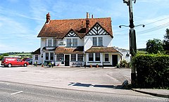
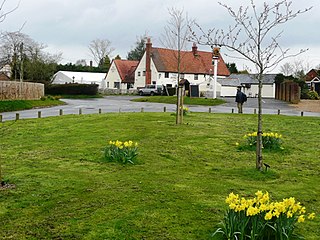
Basildon is a civil parish in the English county of Berkshire. It comprises the small villages of Upper Basildon and Lower Basildon, named for their respective heights above the River Thames.

Sulhamstead is a village and civil parish in West Berkshire, England. It occupies an approximate rectangle of land south of the (Old) Bath Road (A4) between Reading, its nearest town and Thatcham. It has several small clusters of homes and woodland covering about a fifth of the land, in the centre and north beside which is Thames Valley Police's main Training Centre at Sulhamstead House. Its main amenities are its Church of England parish church and a shop and visitor centre by the Kennet & Avon Canal.
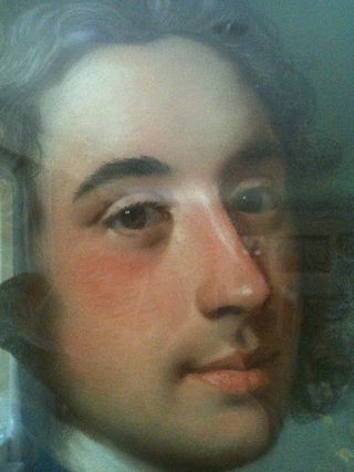
Sir Francis Sykes, 1st Baronet (1732–1804) was an English country landowner and politician who sat in the House of Commons between 1771 and 1804. He was sometime Governor of Cossimbazar in India, being styled an English nabob by his peers.

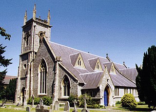
St Bartholomew's Church is the redundant Church of England parish church of Basildon in the English county of Berkshire. It lies in the hamlet of Lower Basildon and is now owned by the Churches Conservation Trust. The church is designated by Historic England as a Grade I listed building.

Kennington is a village and civil parish in the Vale of White Horse district of Oxfordshire, just south of Oxford. The village occupies a narrow stretch of land between the River Thames and the A34 dual carriageway. It was in Berkshire until the 1974 boundary changes transferred it to Oxfordshire.

Moulsford is a village and civil parish in South Oxfordshire. Before 1974 it was in the county of Berkshire, in Wallingford Rural District, but following the Berkshire boundary changes of that year it became a part of Oxfordshire. Moulsford is on the A329, by the River Thames, just north of Streatley and south of Wallingford. The west of the parish is taken up by the foothills of the Berkshire Downs, including the Moulsford Downs. Moulsford Bottom and Kingstanding Hill are traditionally associated with King Alfred and the Battle of Ashdown.

Charles Fane, 1st Viscount Fane PC (Ire) was an Anglo-Irish courtier, politician and a landowner in both England and Ireland.
Charles Fane, 2nd Viscount Fane was a landowner in Ireland and England, a Whig Member of Parliament and the British Resident in Florence.

Lyford is a small village and civil parish on the River Ock about 4 miles (6 km) north of Wantage. Historically it was part of the ecclesiastical parish of Hanney. Lyford was part of Berkshire until the 1974 boundary changes transferred the Vale of White Horse to Oxfordshire. The 2001 Census recorded the parish's population as 44. Lyford's name refers to a former ford across the river Ock, now replaced with a bridge on the road to Charney Bassett. "Ly" is derived from the Old English lin, meaning "flax". In 1034 it was recorded as Linford.

Dunton Wayletts or Dunton is hamlet and former civil parish in the Borough of Basildon in Essex, England. It lies on the western outskirts of the borough's main town of Basildon, adjoining the suburb of Laindon.

Basildon Park is a country house situated 2 miles south of Goring-on-Thames and Streatley in Berkshire, between the villages of Upper Basildon and Lower Basildon. It is owned by the National Trust and is a Grade I listed building. The house was built between 1776 and 1783 for Sir Francis Sykes and designed by John Carr in the Palladian style at a time when Palladianism was giving way to the newly fashionable neoclassicism. Thus, the interiors are in a neoclassical "Adamesque" style.