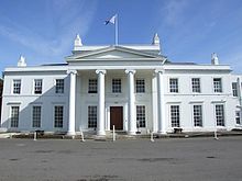
1888 Ordnance Survey Parish Boundary MapTyle Mill LockChurch of St MaryThe 'White House' at Sulhamstead where the Thames Valley Police Museum is housed.
Sulhamstead's immediate neighbours toward its northern border, the A4 road, are the much more populous Theale, which has the nearest railway station and shops, and Ufton Nervet. Across this road is Englefield which has five clusters of homes. The greatest of these is linear, on Sulhamstead Hill Road from the top of the hill by Ufton Church down 1 mile (1.6km) to the water meadows by the River Kennet and the A4 Road. Three further developed points are Sulhamstead Abbots, Whitehouse Green and Sulhamstead Bannister. Finally, Burghfield Common village is in the far south, which is in the remainder of the parish of Burghfield.
Sulhamstead Abbots Church, St Mary's, being to the south, is the active parish church. Sulhamstead Bannister forms the narrowly buffered halves: "Upper End" and "Lower End". Upper End is between Wokefield and Grazeley, although this has since been absorbed into Wokefield civil parish. The core of its village was around the old demolished church, where the inventor Samuel Morland's father was once the vicar.[citation needed] Before 1782, Sulhamstead consisted of two parishes, Sulhamstead Abbots and Sulhamstead Bannister, approximate to the boundaries of the manors of the same name before the medieval period.
History
A Congregational church was built in 1881 in place of an older chapel. The inclosure of the two parishes of Sulhamstead Abbots and Sulhamstead Bannister was made by an act of Parliament,[which?] which was effective in 1817.[2]Grazeley was a tithing in the parish of Sulhamstead Abbots which contained 519 acres (2.10km2). In 1854, when the manorial estate of Grazeley was advertised for sale, it was inclosed in a ring fence and apparently included the whole tithing.[2]
Between 2013 and 2015, eight gold coins from a single treasure hoard were discovered at an undisclosed location near Sulhamstead. The coins are estimated as having been buried between 20 and 30 BC. Six of these coins are quarter staters, similar to some others found in Berkshire and Wiltshire. The remaining two are believed to have originated from North West France. As of 2019, the coins are on display in the West Berkshire Museum, and will continue to be displayed in the museum's 'Hoards' exhibition throughout 2019.[3][4] On 15 August 2019, Sulhamstead was the location of the killing of Andrew Harper, a police officer of the Thames Valley Police Roads Policing Unit, who was responding to reports of a local burglary.[5]
This was built around a small timber-framed cottage dating to around 1650, which was gradually enlarged into a farm house and now survives as a small wing of the house. The house was transformed in 1906 by the Arts and Crafts architect Edwin Lutyens into a country house for H. H. Cochrane. It was extended, by Lutyens, for Zachary Merton, six years later. It is one of Lutyens' best-known house designs. Lutyens collaborated with Gertrude Jekyll to make the diverse, multi-level garden. Folly Farm is a Grade I listed building, as it is an exceptional example of Arts and Craft architecture.[citation needed]
Omer's Gully Wood is a 3.6-hectare (8.9-acre) wood that is bordered to the north-west corner of Burghfield Common. It is mostly owned by Englefield (Manor) Estate, with the remainder owned by the West Berkshire Council. The woodland has historically been well coppiced for firewood. 86 different plant species and 46 different birds have been found and it is a recorded habitat for mammals including foxes, deers, badgers, squirrels and rabbits.[9] This woodland links up with other woodlands by Omers Brook, such as Clayhill Copse, which lies to the north east and is part of a larger natural woodland covered habitat.
This page is based on this Wikipedia article Text is available under the CC BY-SA 4.0 license; additional terms may apply. Images, videos and audio are available under their respective licenses.