
The Royal County of Berkshire, more commonly known as simply Berkshire is a ceremonial county in South East England. It is bordered by Oxfordshire to the north, Buckinghamshire to the northeast, Greater London to the east, Surrey to the southeast, Hampshire to the south, and Wiltshire to the west. The county town is Reading.

Newbury is a market town in the county of Berkshire, England, and is home to the administrative headquarters of West Berkshire Council. The town centre around its large market square retains a rare medieval Cloth Hall, an adjoining half timbered granary, and the 15th-century St Nicolas Church, along with 17th- and 18th-century listed buildings. As well as being home to Newbury Racecourse, it is the headquarters of Vodafone and software company Micro Focus International. In the valley of the River Kennet, 26 mi (42 km) south of Oxford, 25 mi (40 km) north of Winchester, 27 mi (43 km) southeast of Swindon and 20 mi (32 km) west of Reading.

Hungerford is a historic market town and civil parish in Berkshire, England, 8 miles (13 km) west of Newbury, 9 miles (14 km) east of Marlborough, 27 miles (43 km) north-east of Salisbury and 60 miles west of London. The Kennet and Avon Canal passes through the town alongside the River Dun, a major tributary of the River Kennet. The confluence with the Kennet is to the north of the centre whence canal and river both continue east. Amenities include schools, shops, cafés, restaurants, and facilities for the main national sports. Hungerford railway station is a minor stop on the Reading to Taunton Line.

Thatcham is a market town and civil parish in the West Berkshire unitary area of the county of Berkshire, England. It is 3 miles (4.8 km) east of Newbury, 14 miles (23 km) west of Reading and 54 miles (87 km) west of London.
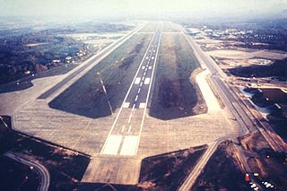
Royal Air Force Greenham Common or RAF Greenham Common is a former Royal Air Force station in the civil parishes of Greenham and Thatcham in the English county of Berkshire. The airfield was southeast of Newbury, about 55 miles (89 km) west of London.

Theale is a village and civil parish in the West Berkshire unitary area of the county of Berkshire, England. It is 5 miles (8 km) southwest of Reading and 10 miles (16 km) east of Thatcham. The compact parish is bounded to the south and south-east by the Kennet & Avon Canal, to the north by a golf course, to the east by the M4 motorway and to the west by the A340 road.

Newbury is a constituency represented in the House of Commons of the UK Parliament from 2019 by Laura Farris, a Conservative. It was created by the Redistribution of Seats Act 1885 and has been in continual existence since then.

Greenham is a village and civil parish in Berkshire, England. Greenham commences immediately south-east of Newbury and is in West Berkshire. It was recorded in the Domesday Book as Greneham.

Beedon is a village and civil parish about 6+1⁄2 miles (10.5 km) north of Newbury in West Berkshire, England.
Welford is a rural village and civil parish in West Berkshire, England occupying both sides of the valley of the River Lambourn north-west of Newbury and south of Wantage. It forms a strip parish which tapers in the south where it contains the hamlet of Halfway. It incorporates Welford Park with its annual snowdrop displays. The M4 motorway passes through the parish, but has no junctions within it. RAF Welford, a munitions depot used by the United States Air Force, is to the north of the village.
"Jack of Newbury" or John Winchcombe, also known as John Smallwood was a leading English clothier from Newbury in Berkshire. When Tudor cloth-making was booming, and woollen cloth dominated English exports, John Winchcombe was producing for export on an industrial scale.

Bowdown and Chamberhouse Woods is a 67.9-hectare (168-acre) biological Site of Special Scientific Interest south of Thatcham in Berkshire. An area of 55 hectares is a nature reserve managed by the Berkshire, Buckinghamshire and Oxfordshire Wildlife Trust.
Heads Hill is a hamlet on Crookham Common in the civil parish of Thatcham in the English county of Berkshire.

Sandleford is a hamlet and former parish in the English county of Berkshire. Since at least 1924, the settlement has been within the civil parish of Greenham, and is located approximately 1.5 miles (2.4 km) south of the town of Newbury.

Greenham and Crookham Commons are two adjoining public park areas of 280.5-hectare (693-acre) common land designated as a biological Site of Special Scientific Interest (SSSI) in the civil parishes of Greenham and Thatcham, on the southern outskirts of Newbury in the English county of Berkshire.

Newbury & Crookham Golf Club is located about two miles from the centre of Newbury, Berkshire on the fringes of Greenham Common. The Club is the result of an amalgamation in 1946 of two clubs: Crookham Golf Club, founded in 1873, and Newbury District Golf Club, founded in 1923.
Edmund Docwra, of Chamberhouse Castle at Crookham near Thatcham in Berkshire, was an English politician.

Sandleford Priory was a small Augustinian Priory, the remains of which now stand at Sandleford in the civil parish of Greenham in the English county of Berkshire.

