
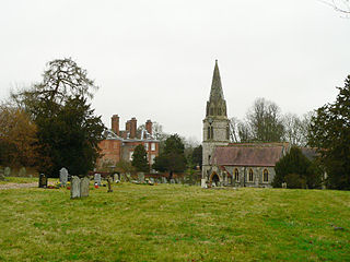
Speen is a village and civil parish in West Berkshire, England. Centred 2 miles (3 km) north west of the largest town in the district, Newbury, Speen has clustered settlements, the largest of which is Speen village, which is contiguous with Newbury, and the others, buffered from the town by the A34 road, are Bagnor, Stockcross, Woodspeen and Marsh Benham. Its other land is an approximately even mixture of woodland and agricultural fields including hay meadows for livestock feed and pasture. The area varies greatly in elevation, having the Reading to Taunton Line alongside the north bank of the River Kennet as its southern boundary and both banks of the River Lambourn in its north with elevated ground in between. Benham Park in the south-west of the area is a listed landscape garden and house.

Hungerford is a historic market town and civil parish in Berkshire, England, 8 miles (13 km) west of Newbury, 9 miles (14 km) east of Marlborough, 27 miles (43 km) northeast of Salisbury and 60 miles west of London. The Kennet and Avon Canal passes through the town alongside the River Dun, a major tributary of the River Kennet. The confluence with the Kennet is to the north of the centre whence canal and river both continue east. Amenities include schools, shops, cafés, restaurants, and facilities for the main national sports. Hungerford railway station is a minor stop on the Reading to Taunton Line.

Harwell is a village and civil parish in the Vale of White Horse about 2 miles (3 km) west of Didcot, 6 miles (10 km) east of Wantage and 13 miles (21 km) south of Oxford. The parish measures about 3.5 miles (6 km) north – south, and almost 2 miles (3 km) east – west at its widest point. In 1923 its area was 2,521 acres (1,020 ha). Historically in Berkshire, it has been administered as part of Oxfordshire, England, since the 1974 boundary changes. The parish includes part of the Milton Park business park in the north and part of Harwell Science and Innovation Campus in the southwest. In the east it includes part of the new Great Western Park housing estate that is contiguous with the built-up area of Didcot. The 2011 census recorded the parish's population as 2,349.

Thatcham is an historic market town and civil parish in the English county of Berkshire, centred 3 miles (4.8 km) east of Newbury, 14 miles (23 km) west of Reading and 54 miles (87 km) west of London.

Theale is a village and civil parish in West Berkshire, England, 5 miles (8 km) southwest of Reading and 10 miles (16 km) east of Thatcham. The compact parish is bounded to the south and south-east by the Kennet & Avon Canal, to the north by a golf course, to the east by the M4 motorway and to the west by the A340 road. The village's history is a good example of how different modes of transport have achieved dominance in England over the last three centuries, from road to canal to railway and back to road again.
Overstone is a village and civil parish in West Northamptonshire, England. At the time of the 2001 census, the parish's population was 650 people, increasing to 741 at the 2011 Census.

Greenham is a village and civil parish in Berkshire, England. Greenham commences immediately south-east of Newbury and is in West Berkshire. It was recorded in the Domesday Book as Greneham.

World's End is a hamlet in Berkshire, England. It is in the district of West Berkshire, near the A34 north of Newbury. To the north is the village of Beedon ; to the south lie Downend and Chieveley. World's End is in the parish of Beedon.

Woolhampton is a village and civil parish in West Berkshire, England. The village straddles the Bath road between the towns of Reading, 8 mi (13 km) to the east, and Newbury, 6 mi (9.7 km) to the west.

Upper Lambourn is a small village in the county of Berkshire, England. The village is situated in the civil parish of Lambourn, and is 1.2 miles (2 km) to the north-west of the village of Lambourn, just off the Lambourn to Shrivenham road. The parish is within the district of West Berkshire, close to the point where the counties of Berkshire, Oxfordshire and Wiltshire meet.

Boxford is a village and civil parish in the unitary authority of West Berkshire, England. The village is on the east bank of the River Lambourn, about 4 miles (6.4 km) northwest of Newbury but south of the M4 motorway. The hamlet of Westbrook is on the opposite bank of the Berkshire Downs tributary.

East Ilsley is a village and civil parish in the Berkshire Downs in West Berkshire, north of Newbury. The village is centred immediately east of the A34 dual carriageway which passes the length of the village from north to south. It has the vast majority of its buildings in a traditional clustered centre.
Welford is a rural village and civil parish in West Berkshire, England occupying both sides of the valley of the River Lambourn north-west of Newbury and south of Wantage. It forms a strip parish which tapers in the south where it contains the hamlet of Halfway. It incorporates Welford Park with its annual snowdrop displays. The M4 motorway passes through the parish, but has no junctions within it. RAF Welford, a munitions depot used by the United States Air Force, is to the north of the village.

Wasing is an agricultural and woodland village, country estate and civil parish in West Berkshire, England owned almost wholly by the descendants of the Mount family. In local administration, its few inhabitants convene their own civil parish, but share many facilities with Brimpton which was in its civil parish at the time of the 2011 Census.
Ashmansworth is a village and civil parish in the Basingstoke and Deane district of the English county of Hampshire.

East Lockinge is a village in Lockinge civil parish, about 1.5 miles (2.4 km) east of Wantage. It was part of Berkshire until the 1974 local authority boundary changes transferred the Vale of White Horse to Oxfordshire. The village is included within the North Wessex Downs Area of Outstanding Natural Beauty (AONB).

Lyford is a village and civil parish on the River Ock about 4 miles (6.4 km) north of Wantage. Historically it was part of the ecclesiastical parish of Hanney. Lyford was part of Berkshire until the 1974 boundary changes transferred the Vale of White Horse to Oxfordshire. The 2001 Census recorded the parish's population as 44. Lyford's toponym refers to a former ford the Ock, now replaced with a bridge on the road to Charney Bassett. "Ly" is derived from the Old English lin, meaning "flax". In 1034 it was recorded as Linford.

Brightwalton Green is a hamlet in the civil parish of Brightwalton in the county of Berkshire, England. The settlement lies near to the A338 road, and is situated approximately 8 miles (13 km) north-west of Newbury.

Crockham Heath is a hamlet in Berkshire, England. Crockham Heath is part of the civil parish of Enborne. The settlement lies near to the A34 road, and is located approximately 3 miles (4.8 km) south-west of Newbury.
Enborne Row is a hamlet in Berkshire, England, located on the county's border with Hampshire. The hamlet is within the civil parish of Enborne. The settlement lies next to the A34 road, and is located approximately 3 miles (4.8 km) south-west of Newbury. The name Enborne comes from Old English and means duck stream.

