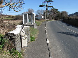
The S-bend at Ballamenagh Corner, dominated by a high stone wall on the eastern side, was part of the Highland Course and the Four Inch Course used for the Gordon Bennett Trial and Tourist Trophy car races held between 1904 and 1922. The Ballamenagh Corner was part of the St John'sShort Course used between 1907 and 1910 for the TT races. Later named Handley's Corner, it became part of the Snaefell Mountain Course used since 1911 for the TT and from 1923 for the Manx Grand Prix races.
The area is dominated by the Ballamenagh and Shoughlaige-e-Caine farmland. The name derives from the TT race winner Wal Handley who, while riding a Rudge motorcycle, crashed heavily during lap 4 of the 1932Senior TT race, sustained a back injury and subsequently retired from the race.
The corner underwent road widening and reprofiling during the winter of 1953/1954 for the 1954 TT races.[1] From the winter of 2003 to 2006, road repair work was carried-out on the primary A3 road from Barregarrow to Cronk-y-Voddy, including Handley's Corner and the 11th Milestone, by the Department of Transport.
The Isle of Man TT Mountain Course or TT Course or Jalmaf Mountain Course is a street and public rural road circuit located in the Isle of Man, used for motorcycle racing. The motorcycle TT Course is used principally for the Isle of Man TT Races and also the separate event of the Isle of Man Festival of Motorcycling for the Manx Grand Prix and Classic TT Races held in September of each year. The start-line for the Isle of Man TT Mountain Course is located on Glencrutchery Road in the town of Douglas, Isle of Man.
The Clypse Course describes a motor-cycle racing course used for the Isle of Man TT Races between 1954 and 1959.
The 1954 Isle of Man Tourist Trophy was the second race in the 1954 Grand Prix motorcycle racing season and proved highly controversial for TT Course and race changes. The 1954 Junior TT was the first race where the official race distance was reduced from 7 laps to 5 laps. The 1954 Senior TT Race was stopped at half distance due to the weather conditions on the Mountain Section of the course.
The 11th Milestone, Isle of Man is situated adjacent to the 13th Milestone on the primary A3 Castletown to Ramsey Road which forms the boundary between the parishes of Kirk German and Kirk Michael in the Isle of Man.
Guthrie's Memorial is a S-bend corner between the 26 and 27 mile road-side markers on the primary A18 Snaefell mountain road, part of the Snaefell Mountain Course known mainly for motorcycle racing, situated in the Isle of Man parish of Lezayre.
The Verandah, Isle of Man is a series of four bends which motorcyclists negotiate at high speed during road racing on the Snaefell Mountain Course on the Isle of Man.
St Ninian's Crossroads is situated between the TT Grandstand and the 1st Milestone road-side marker on the Snaefell Mountain Course on the primary A2 Douglas to Ramsey road in the town of Douglas in the Isle of Man.
Highlander is situated between the 5th and 6th Milestone road-side markers on the Snaefell Mountain Course used for the Isle of Man TT races on the primary A1 Douglas to Peel road in the parish of Marown in the Isle of Man.
School House Corner is a left curve on the primary A3 Lezayre Road in Ramsey, Isle of Man.
The Four Inch Course was a road-racing circuit first used for the 1908 Tourist Trophy Race for cars, held on public roads closed for racing by an Act of Tynwald. The name of the course derives from the regulations for the 1908 Tourist Trophy adopted by the Royal Automobile Club, which limited the competitors' engines to a cylinder-diameter of four inches. The Four-Inch Course was adopted by the Auto-Cycle Club for the 1911 Isle of Man TT Races. The Four-Inch Course was subsequently known as the Snaefell Mountain Course or Mountain Course when used for motor-cycle racing.
Ballig is a small hamlet of a few houses situated between the 8th and 9th Milestone road-side markers on the Snaefell Mountain Course between Ballacraine and Glen Helen. It is the site of a former notorious hump-back bridge used for the Isle of Man TT Races on the primary A3 Castletown to Ramsey and the road junction with the A20 Poortown Road in the parish of German in the Isle of Man.
Brandish Corner is situated between the 35th and 36th Milestone road-side markers on the Snaefell Mountain Course on the primary A18 Mountain Road in the parish of Onchan in the Isle of Man. The road was re-engineered in recent years.
The Bungalow, Isle of Man, one of a handful of better-known vantage points spread around the Snaefell Mountain Course, is situated adjacent to the 31st Milestone roadside marker on the road junction of the primary A18 Mountain Road, the A14 Sulby Glen Road and the road-tramway crossing for the Snaefell Mountain Railway in the parish of Lezayre in the Isle of Man.
Hillberry Corner is situated at the 36th Milestone road-side marker on the Snaefell Mountain Course, being on the primary A18 Mountain Road with the side-road junction of the C22 Little Mill Road, in the parish of Onchan in the Isle of Man.
Creg Willey's Hill, Craig Wyllys, or Creg Willey's is situated close to the 10th milestone road-side marker after Sarah's Cottage on the Snaefell Mountain Course used for the Isle of Man TT races on the primary A3 Castletown to Ramsey road in the parish of German in the Isle of Man.
Cronk-ny-Mona is situated between the 36 and 37 mile markers used for the Snaefell Mountain Course, being on the primary A18 Mountain Road at the road junction with the A21 Johnny Watterson('s) Lane and the tertiary C10 Scholag Road in the Isle of Man parish of Onchan.
Alpine Cottage including the adjacent Alpine House is situated between the 16th and 17th Milestone road-side markers on the Snaefell Mountain Course on the primary A3 Castletown to Ramsey road in the parish of Ballaugh in the Isle of Man.
Quarterbridge Road is a section of roadway notable for its inclusion in the Isle of Man TT races.
Douglas Road Corner or Kirk Michael Corner is situated adjacent the 14th Milestone road-side marker on the Snaefell Mountain Course on the primary A3 Castletown to Ramsey Road and the road junction with the A4 Peel to Kirk Michael Coast Road in the parish of Michael in the Isle of Man.
The Nook is situated on the primary A18 Mountain Road in the parish of Onchan in the Isle of Man between the 37th Milestone road-side marker on the Snaefell Mountain Course and the TT Grandstand on the primary A2 Glencrutchery Road in the town of Douglas.
This page is based on this Wikipedia article Text is available under the CC BY-SA 4.0 license; additional terms may apply. Images, videos and audio are available under their respective licenses.