
Harvard Yard, in Cambridge, Massachusetts, is the oldest part of the Harvard University campus, its historic center and modern crossroads. It contains most of the freshman dormitories, Harvard's most important libraries, Memorial Church, several classroom and departmental buildings, and the offices of senior University officials including the President of Harvard University.

Harvard Square is a triangular plaza at the intersection of Massachusetts Avenue, Brattle Street and John F. Kennedy Street near the center of Cambridge, Massachusetts, United States. The term "Harvard Square" is also used to delineate the business district and Harvard University surrounding that intersection, which is the historic center of Cambridge. Adjacent to Harvard Yard, the historic heart of Harvard University, the Square functions as a commercial center for Harvard students, as well as residents of western Cambridge, the western and northern neighborhoods and the inner suburbs of Boston. The Square is served by Harvard station, a major MBTA Red Line subway and a bus transportation hub.

Massachusetts Avenue is a major diagonal transverse road in Washington, D.C., and the Massachusetts Avenue Historic District is a historic district that includes part of it.

Spring Hill is the name of a ridge in the central part of the city of Somerville, Massachusetts, and the residential neighborhood that sits atop it. It runs northwest to southeast, roughly bounded by Highland Avenue, Somerville Avenue, Elm Street, and Willow Avenue. Summer Street runs along the hill's crest.

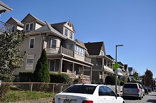
The Harvard Avenue Historic District is a historic district roughly bounded by Linden Street, Commonwealth Avenue, Harvard Avenue, and Park Vale Avenue in the Allston neighborhood of Boston, Massachusetts. Its spine is Harvard Avenue, a major north–south thoroughfare connecting Allston to points north, and south toward Brookline. The area underwent a population explosion in the early 20th century, and Harvard Avenue was developed roughly between 1905 and 1925 as a commercial and residential spine. Notable buildings in the district include the Allston Station building, designed by Shepley, Rutan and Coolidge, and the Harvard Avenue Fire Station.

Morton Street is a street in southern Boston, Massachusetts, United States. It extends from the southeastern end of the Arborway in Jamaica Plain to Washington Street in the Lower Mills Village of Dorchester. Most of the road is a connecting parkway, signed as part of Massachusetts Route 203, that provides access to Boston's Emerald Necklace of parks. That portion of the road was listed on the National Register of Historic Places in 2005.
The Ash Street Historic District Cambridge, Massachusetts is a residential historic district on Ash Street and Ash Street Place between Brattle and Mount Auburn Streets in Cambridge, Massachusetts, off Brattle Street just west of Harvard Square. The district consists of ten well-preserved houses, most of which were built between 1850 and 1890. The district was listed on the National Register of Historic Places in 1982.

The Avon Hill Historic District is a residential historic district near Porter Square in Cambridge, Massachusetts. Set atop Avon Hill southwest of Porter Square, this subdivision, laid out about 1870, contains a concentration of the finest Victorian and Second Empire residential buildings in the city. The district was listed on the National Register of Historic Places in 1983.

The Bigelow Street Historic District encompasses a uniform collection of 19th century houses on most of the length of Bigelow Street in Cambridge, Massachusetts, just northwest of Central Square. Bigelow Street was laid out in 1868, and the street was almost completely built out by 1874, resulting in a fairly uniform streetscape of Second Empire architecture. The district was added to the National Register of Historic Places in 1982.

The Cambridge Common Historic District is a historic district encompassing one of the oldest parts of Cambridge, Massachusetts. It is centered on the Cambridge Common, which was a center of civic activity in Cambridge after its founding in 1631. It was the site of the election for governor of the Massachusetts Bay Colony in 1636, and was a military barracks site during the American Revolutionary War. The common was gradually reduced in size to its present roughly triangular shape, and surrounded by buildings in the 18th and 19th centuries. In 1973 a historic district encompassing the extant common and everything within 100 feet (30 m) of it was listed on the National Register of Historic Places. In 1987 the district was amended to rationalize the boundary, which overlapped adjacent districts and included portions of some buildings.

The Maple Avenue Historic District is a residential historic district on Maple Avenue between Marie Avenue and Broadway in Cambridge, Massachusetts. It encompasses a street with a cohesive collection of well-preserved, predominantly Italianate and Second Empire, houses, in which the original spacing and setting has been preserved. It includes houses on both sides of Maple Avenue, numbered from 8 to 33, among which stand several Queen Anne and Colonial Revival houses. The district was added to the National Register of Historic Places in 1983.

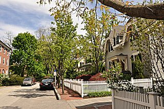
The Old Cambridge Historic District is a historic district encompassing a residential neighborhood of Cambridge, Massachusetts that dates to colonial times. It is located just west of Harvard Square, and includes all of the properties on Brattle Street west of Mason Street to Fresh Pond Parkway, all of the properties on Mason Street and Elmwood Avenue, and nearby properties on Craigie Street. The district includes five National Historic Landmarks: Elmwood, the Reginald A. Daly House, the Oliver Hastings House, the Mary Fiske Stoughton House, and the Longfellow House–Washington's Headquarters National Historic Site, as well as several other houses listed separately on the National Register. The district follows the general route of the Watertown Path, an early colonial road that supposedly followed a Native American trail. This portion of the way became known as Tory Row during the American Revolution, because many of the fine mansions lining it were owned by Loyalists. In the 19th and early 20th centuries it continued by a fashionable location, and now features a number of architecturally significant buildings. It includes 215 contributing buildings and one other contributing sites over an area of 52 acres (21 ha). One included building is the Cambridge Historical Society's offices, which are in the NRHP-listed Hooper-Lee Nichols House, located at 159 Brattle Street.

The North Irvington Gardens Historic District is a neighborhood and national historic district in Indianapolis, Indiana. It was placed on the National Register of Historic Places on June 27, 2008. It is immediately to the north of the Irvington Historic District, which has been on the National Register since 1987, sharing the same east and west boundaries of the older district, and extending north to 10th and 11th streets. It is a neighborhood of mostly residential buildings dating primarily from 1910 to 1950, with no one distinctive architectural style, including a house associated with the historic Osborn Farm. Except for one church, the only buildings contributing to the historic nature of the district are 843 houses and 551 garages. Most fences in the district mark the perimeter of the individual properties; very few are along the streets.

The Taconic and West Avenues Historic District is a largely residential historic district south of the downtown area of Great Barrington, Massachusetts. The roughly 117-acre (47 ha) district includes 172 contributing elements, most of which are houses or related buildings. Two thirds of the buildings were built between 1890 and 1910, and most of the rest were constructed in a historically sympathetic way.
The Diamond Historic District is a seaside, 69.5-acre (28.1 ha) National Register historic district in Lynn, Massachusetts. Established by the National Park Service in 1996, the district is situated between downtown Lynn and the Atlantic Ocean—bounded roughly by Broad and Lewis Streets to the north, Lynn Shore Drive to the southeast, Nahant Street to the west, and Eastern Avenue to the east. The Diamond Historic District encompasses 590 contributing resources.

The Charles River Reservation Parkways are parkways that run along either side of the Charles River in eastern Massachusetts. The roads are contained within the Charles River Reservation and the Upper Charles River Reservation, and fall within a number of communities in the greater Boston metropolitan area. The Charles River parks extend from the Charles River Dam, where the Charles empties into Boston Harbor, to Riverdale Park in the West Roxbury neighborhood of Boston. Most of the roadways within the parks are listed on the National Register of Historic Places as a unit, although Storrow Drive and Memorial Drive are listed as part of the Charles River Basin Historic District.
The Arlington Center Historic District includes the civic and commercial heart of Arlington, Massachusetts. It runs along the town's main commercial district, Massachusetts Avenue, from Jason Street to Franklin Street, and includes adjacent 19th- and early 20th-century residential areas roughly bounded by Jason Street, Pleasant Street, and Gray Street. The district was listed on the National Register of Historic Places in 1974.

The Everett Avenue–Sheffield Road Historic District is a historic district encompassing one of the finest residential districts from the turn of the 20th century in Winchester, Massachusetts. The district is roughly triangular in shape, bounded in the north by Bacon Street, on the west by Church Street, Sheffield West, and Sheffield Road, and on the south and heast by the Upper Mystic Lake and Mystic Valley Parkway. It is characterized by winding roads, with relatively large houses on well-proportioned lots. Most of the houses were built between 1890 and 1916, and all exhibit some architectural sophistication. A significant number of properties were designed by either F. Patterson Smith or Dexter Blaikie, two local architects. The district was listed on the National Register of Historic Places in 1989.

The Fort Madison Downtown Commercial Historic District has a collection of late-19th century store fronts centered on Ave. G, from 6th to 9th Street, and Ave. H from 7th to 9th, in Fort Madison, Iowa. It was listed on the National Register of Historic Places in 2007.
The Esmond Street Historic District is a historic district encompassing a small residential area in the Dorchester neighborhood of Boston, Massachusetts. Centered on a stretch of Esmond Street, the area was developed between 1884 and 1928, and includes a fine sample of Colonial Revival and Queen Anne architecture. The district was listed on the National Register of Historic Places in 2018.


