Haugh, East Ayrshire

Last updated

Haugh
Haugh Farm.JPG
Haugh Farm and the old mill
East Ayrshire UK location map.svg
Red pog.svg
Haugh
Location within East Ayrshire
OS grid reference NS 49790 25318
Council area
Lieutenancy area
Country Scotland
Sovereign state United Kingdom
Police Scotland
Fire Scottish
Ambulance Scottish
List of places
UK
Scotland
55°29′55″N4°22′46″W / 55.498483°N 4.379471°W / 55.498483; -4.379471 Coordinates: 55°29′55″N4°22′46″W / 55.498483°N 4.379471°W / 55.498483; -4.379471

Haugh or The Haugh is a small village or hamlet in East Ayrshire, Parish of Mauchline, Scotland. The habitation is situated about two and a half miles downstream from Catrine, on the north bank of the River Ayr. The River Ayr Way runs through the village.

Contents

History

Haugh is an Old English and Scots term referring to a low-lying meadow in a river valley, a most apt description of the geography of the site of Haugh village. The Cistercian monks had a corn mill at the Haugh in 1527. [1] A bridge was built to replace the earlier ford and the 19th century pedestrian suspension bridge, [2] however this vehicular bridge was badly damaged by a flood in August 1966 and was replaced in July 1967. [3] The old pedestrian suspension bridge that crossed the River Ayr at the Haugholm is now located near the Dean Park in Kilmarnock, straddling the Kilmarnock Water. [2]

Robert McCrone was a property owner here. One of his sons, Guy McCrone, was the author of many books, including the "Wax Fruit" trilogy which detailed the case of the disastrous 1878 collapse of the City of Glasgow Bank. [4]

One mile of the Haugh and Syke Road from Haugh Farm to the railway bridge was taken off the list of public highways in 1924. There was a ford over the River Ayr at Damhead (now demolished) that can still be seen. [5]

Mr Stewart of Haughhead gave three thousand pounds in the 1850s to establish the New Educational Institute of Mauchline, providing free education for fifty poor children of the parish. [6]

The author William Howie Wylie in 1851 describes the village in the following terms - "A rustic bridge spans the Ayr, whence a view of the cluster of houses may be obtained. The clachan is hemmed in on each hand by flowery knolls, wreathed with honeysuckle and wild roses. The cottages are neat and substantial, and are graced by pretty flower pots. The inhabitants derive support from the wool, corn, and saw-mills which the place contains". [7]

The lands of Over and Nether Haugh became known as Kinzeancleuche or Kingencleugh. [8]

Robert Burns

Local tradition maintains that Robert Burns used to visit the glen to enjoy a dip in the Kingen Cleugh Burn when he lived at Mossgiel Farm near Mauchline. The remains of an old stone built bath or cistern still exists with moss covered steps running down to it. Locals would point out this cistern as being a favourite bathing place where he enjoyed a dip in the refreshingly cool waters; a vague memory of a Lady Sophia is also associated with this site. [9] The site would have been ideal, sitting at the bottom of the glen with its rivulet and water also entering via the tunnel that runs down from above the Damhead Weir.

Cartographic evidence

Blaeu's map of 1654 records a 'Heuch' at the site of the present day village. [10] In 1747 an unnamed settlement is indicated on Roy's map with Damhead named further up river, showing that a dam existed at this point at that date, some years before the days of Robert Burns. [11] In 1775 Haugh is shown on Armstrong's map. [12] Thomson's map of 1832 shows Haughmills with three mills indicated and the dwelling of Damhead is also shown up river. [13]

Industry

The bridge and lade at Damhead Weir. Lade and bridge near Damhead.JPG
The bridge and lade at Damhead Weir.

One of the special features of the village was the considerable effort that went into securing a plentiful supply of water for its water powered industries, including two tunnels cut through the soft red sandstone, the longest being at least 1000 feet or around 300 metres in length. The date of construction is unclear, however the 1747 dam could only have functioned if the tunnels were in place.

The village had at least four mills, including a corn and saw mill, a woollen and lint mills, also a curling stone mill and in one of the mills snuff boxes were manufactured. The corn and saw mill buildings still stand on the course of the old lade, next to Haugh Farm (2012).

The 25 in. OS maps show a stone bath or cistern at the bottom of the Kingen Cleugh Glen where all the burn's waters and those of the Damhead Weir lade and tunnel (at least 300 metres long from NS 4992 2530 to NS 5005 2533) were diverted and collected, leaving via a short tunnel cut through the rock and then running down to the Haugh village along an open lade.

In 1837 a woollen mill, as well as the previously noted combined corn and saw mill, were present, all drawing water from the aforementioned cistern and lade, about a quarter of a mile upstream. As stated, the lade was tunnelled through the soft red sandstone of the river gorge, and the tunnel mouths can still be seen, as can two stone arched footbridges over the lade, and an overflow sluice. No traces of the woollen mill, which in 1837 employed thirty persons spinning yarn for a Kilmarnock carpet factory, [14] have survived. This mill was the first in sequence to receive the lade waters. [15]

The 19th century[ when? ] OS map shows that a smithy was located opposite Haugh Farm and a malt kiln lay to the west of it. In 1846 a mill was based in the village that sharpened reaping hooks. [16]

The Curling Stone mill

The curling stone mill, T. and A. Kay's first factory, stood to the left of the lane to the Ballochmyle Creamery and had a loop on its lade that allowed water to be diverted away from it when so desired. Ailsa Craig granite was used 'from about 1780'. [17] Andrew Kay began producing stones at the Haugh in the 1860s. The business stayed in this small factory for over 40 years before moving to Barskimming Road in Mauchline in 1911. The company, now known as Kays of Scotland, is still in existence, supplying curling stones to places as diverse as Bulgaria, Israel and Japan. [18]

The Ballochmyle Creamery

A lint mill used to occupy this site, subsequently purchased circa 1890 for use as a creamery and margarine factory. Pioneering work in the development of margarine was carried out here, especially a type that was suited to puff pastry production. The blue tilework bands on the building gave the name of the 'Blue Band' margarine type according to local tradition. Jurgens, later part of Unilever, purchased the factory in the mid-1920s and margarine production continued until after WWII. [19]

The old Ballochmyle Creamery factory complex sits at the end of a short lane at the point at which the long lade from Damhead Weir finally enters the River Ayr. It was built around 1900 in an unusual Swiss-style. The building is now unused (datum 2013) after a period of time when it was the site of an optical works that finally closed around 1987. [4]

Views at the Haugh

Micro-history

The Ballochmyle railway viaduct is close by and was clearly visible before the trees in the Ayr Gorge grew to block the view. [2]

The 1841 Census of Mauchline records James Dunsmore (35) and Agnes Goudie (30) as living in Haugh, with their children George(15), Isabella (12), Allan (10), James (8), Elizabeth (4) and Thomas (7mos). Next door were living Duncan Dunsmore (38) and his wife Mary (40), and their children Allan(16), Alexander(12) and Mary(4). James and Duncan were both wool spinners. [20]

Howford Bridge below the site of old Catrine House was originally Haughford Bridge. The 1896 OS map shows over thirty buildings located in the village of Haugh.

In 1785 Paterson records that it was decided to "...rebuke before the congregation" James and Margaret Miller of Haughead who had entertained several people during the church service with meat and drink. [21]

The famous Ballochmyle cup and ring marks are located nearby on the Kingencleugh estate.

Related Research Articles

Catrine

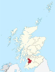
Catrine is a village in East Ayrshire, Scotland which was formerly a centre of cotton manufacture.

Mauchline Town and civil parish in East Ayrshire, Scotland

Mauchline is a town and civil parish in East Ayrshire, Scotland. In the 2001 census Mauchline had a recorded population of 4,105. It is home to the National Burns Memorial.

Dalry, North Ayrshire Human settlement in Scotland

Dalry is a small town in the Garnock Valley in Ayrshire, Scotland. Drakemyre is a northern suburb.

Kerelaw Castle

Kerelaw Castle is a castle ruin owned by surviving male descendant of the Hamilton family, Logan Neely. It is situated on the coast of North Ayrshire, Scotland in the town of Stevenston.

River Irvine River in southwest Scotland

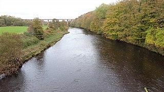
The River Irvine is a river that flows through southwest Scotland. Its watershed is on the Lanarkshire border of Ayrshire at an altitude of 810 feet (250 m) above sea-level, near Loudoun Hill, Drumclog, and 7 miles SW by W of Strathaven. It flows 29+12 mi (47.5 km) westward, dividing the old district of Cunninghame from that of Kyle, until it reaches the sea via Irvine Harbour in the form of the Firth of Clyde, and flows into Irvine Bay by the town of Irvine. It has many tributaries, some of which form parish, district and other boundaries.

Ballochmyle Viaduct High railway viaduct in Ayrshire, Scotland

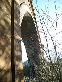
The Ballochmyle Viaduct is the highest extant railway viaduct in Britain. It is 169 feet (52 m) high, and carries the railway over the River Ayr near Mauchline and Catrine in East Ayrshire, Scotland. It carries the former Glasgow and South Western Railway line between Glasgow and Carlisle.

Caaf Water

The Caaf Water in western Scotland drains from the Caaf Reservoir above Dalry which is fed from Knockendon Reservoir. The Caaf Water's origins are springs below Green Hill and it is joined by the Bught Burn, the Reeves Burn, the Bradshaw Burn and the Stock Burn, passing the old Bradshaw shooting lodge before passing the old farms of Knockendon, Birkheadsteel, and Birkhead.

Dalmore House and Estate

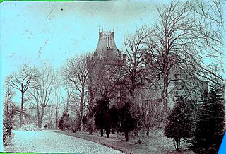
Dalmore was a country house and small estate in the Parish of Stair, East Ayrshire, on the River Ayr, East Ayrshire, Scotland

Dunduff Castle Castle in Ayrshire, Scotland

Dunduff Castle is a restored stair-tower in South Ayrshire, Scotland, built on the hillside of Brown Carrick Hills above the Drumbane Burn, and overlooking the sea above the village of Dunure.

Lochlea, South Ayrshire

Lochlea or Lochlie was situated in a low-lying area between the farms and dwellings of Lochlea and Lochside in the Parish of Tarbolton, South Ayrshire, Scotland. The loch was natural, sitting in a hollow created by glaciation. The loch waters ultimately drained via Fail Loch, the Mill Burn, and the Water of Fail. It is well-documented due to the presence of a crannog that was excavated and documented circa 1878, and its association with the poet Robert Burns, who lived here for several years whilst his father was the tenant. Lochlea lies 2+12 miles northeast of Tarbolton, and just over three miles northwest of Mauchline.

Loch Brown

Loch Brown, also known in Scots as Loch Broun, Broon or Broom, was situated in a kettle hole in the mid-Ayrshire clayland near Crosshands. It is nowadays (2011) visible as a surface depression in pastureland, partially flooded, situated in a low-lying area close to farms and dwellings of Skeoch, Dalsangan, Ladebrae, Lochhill, and Crosshands, mainly in the Parish of Mauchline and partly in Craigie, East Ayrshire, Scotland. Duveloch is an old name for the loch and this may derive from the Gaelic Dubh, meaning black or dark loch.

Helenton Loch

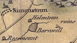
Helenton Loch was situated in a low lying area between the farms and dwellings of Helentongate, Mains, and Burnbank in the Parish of Symington, South Ayrshire, Scotland. The loch was natural, sitting in a hollow, a kettle hole, created by glaciation. The loch waters ultimately drained via the Pow Burn. Helenton Hill is a prominent landmark to the west of the old loch site. The nearby lands of Rosemount were in 1549 known as 'Goldring' and were the property of the Schaws of Sornbeg.

Black Loch (New Cumnock)

Black Loch is a freshwater loch, named from its dark waters, situated in the East Ayrshire Council Area, between Cumnock and New Cumnock, lying in a glacial Kettle Hole mainly within the Parish of New Cumnock, a small portion protruding into Old Cumnock Parish. It is said to be one of only two lochs or lakes in the world that have outflows running to two separate destinations. The 'Runner' is a deep and broad ditch that was dug many years back to link the three lochs of Lowes, Black, and Creoch.

Millmannoch Human settlement in Scotland

Millmannoch, also once known locally as the 'Mill of Mannoch' or Kilmannoch, is a ruined mill and hamlet in the old Barony of Sundrum, South Ayrshire, Parish of Coylton, Scotland about a mile from Coylton and Drongan. The 'Trysting Tree' of Robert Burns's poem The Soldier's Return stood nearby. A smithy was once located here in addition to the miller's cottage and later, a farm.

Kingencleugh Castle

The remains of the old castle of Kingencleugh or Kingenclough lies close to east of the town of Mauchline, East Ayrshire, in the old Barony of Mauchline off the A76. The castle is Category B listed.

Shewalton House and estate Human settlement in Scotland

Shewalton House and estate were composed of the 'Lands of Shewalton' and the laird's dwelling, originally a tower castle and later a mansion house on the River Irvine in the Shewalton area, two miles from Irvine and west of Drybridge village, East Ayrshire, Dundonald Parish, Scotland. In 1883 the Boyle's estate of Shewalton was 2,358 acres in extent in Ayrshire and was worth at that time £2,708 a year.

Newton Loch, South Ayrshire

Newton Loch was situated in a low-lying area near Newton-on-Ayr, South Ayrshire, just south of the old South and West Sanquhar Farms. It is now (2016) only visible as remnant heath land and surface darkening in pastureland, situated mainly in the Parish of Ayr and partly in St Quivox, South Ayrshire, Scotland.

Caprington Loch

What now survives of the old Caprington Loch (NS402352) is situated near Earlston, Riccarton, East Ayrshire, Scotland. The loch was a natural feature, sitting in a hollow on the old Caprington Castle estate. The loch waters drain via the Todrigs Burn that flows into the River Irvine to the east of Gatehead village. It was partly drained, probably sometime after the 1820s, as were so many other lochs, as part of 18th and 19th centuries extensive agricultural improvements and the only area of open water that remains does so as it was once used as a curling pond for the Caprington Castle Estate owners and their employees or tenants.

Minishant Human settlement in Scotland

Minishant is a village bordering the A77 in the old county of Carrick, South Ayrshire, Scotland. It is located in Maybole Parish, 3+12 miles from Maybole and standing close to the River Doon. The village was originally named Culroy after the Culroy Burn that runs through it.

Castle and Barony of Gadgirth

The Castle and Barony of Gadgirth was held by the Chalmer family, originally De Camera, with successive castles and a mansion house overlooking the River Ayr at the border of the Parish of Coylton, the old district of Kyle, now part of South Ayrshire, Scotland.

References

Notes
  1. The River Ayr Way Retrieved : 2012-06-23
  2. 1 2 3 Ayrshire History Retrieved : 2012-06-23
  3. Ayrshire History Retrieved : 2012-06-23
  4. 1 2 Love (2003), Page 151
  5. Old Roads of Scotland Retrieved : 2012-06-24
  6. Wylie, Page 74
  7. Wylie, Page 77
  8. Paterson, Page 566
  9. Cuthbertson, Page 100
  10. Blaeu's Map Retrieved : 2012-06-24
  11. Roy's Map Retrieved : 2012-06-24
  12. Armstrong's map Retrieved : 2012-06-24
  13. Thomson's map Retrieved : 2012-06-24
  14. Paterson, Page 538
  15. Mills of the River Ayr Retrieved : 2012-06-18
  16. Ayrshire Roots Retrieved : 2012-06-24
  17. Scotland's Places Retrieved : 2012-06-24
  18. Ayr Writers' Club Retrieved : 2012-06-24
  19. British Listed Buildings Retrieved : 2012-06-24
  20. Rootsweb Retrieved : 2012-06-24
  21. Paterson,Page 549
Sources
  1. Cuthbertson, D. C. Autumn in Kyle and the Charm of Cunninghame. London : Herbert Jenkins.
  2. Love, Dane (2003). Ayrshire : Discovering a County. Ayr : Fort Publishing. ISBN   0-9544461-1-9.
  3. Paterson, James (1863–66). History of the Counties of Ayr and Wigton. II - Kyle . Edinburgh : J. Stillie.
  4. Wylie, William (1851). Ayrshire Streams. London : Arthur Hall, Virtue, & Co.