Galston, East Ayrshire

Last updated

Galston
Town
Galston from the air (geograph 2071561).jpg
Aerial view
East Ayrshire UK location map.svg
Red pog.svg
Galston
Location within East Ayrshire
Population4,710 (mid-2020 est.) [1]
Language English
Scots
Scottish Gaelic
OS grid reference NS569200
Council area
Lieutenancy area
Country Scotland
Sovereign state United Kingdom
Post town Galston
Postcode district KA4
Dialling code 01563
Police Scotland
Fire Scottish
Ambulance Scottish
UK Parliament
Scottish Parliament
List of places
UK
Scotland
55°36′01″N4°22′47″W / 55.60037°N 4.3798°W / 55.60037; -4.3798

Galston (Lowland Scots: Gauston, Scottish Gaelic: Baile nan Gall) is a municipality in East Ayrshire, Scotland, which has a population of 5,001 (2001) [2] and is at the heart of the civil parish of the same name. It is situated in wooded countryside four miles (six kilometres) upriver from Kilmarnock and is one a group of the small towns located in the Irvine Valley between the towns of Hurlford and Newmilns. To the north of the town is the ruin of Loudoun Castle, the site of Loudoun Castle theme park from 1995 to 2010. In 1874 the population was 4,727. [3]

Contents

Etymology

The name Galston means "place of the strangers" from the Gaelic word Gall (a stranger), and the Toun or Ton was a farm and its outbuildings. The word baile was anglicised in more recent history as toun like many other place names in Scotland which were originally "bal". [4]

Churches

The Burn Anne

A view of the Burn Anne at Bank Wood Bridge. Burnawnbankwood.JPG
A view of the Burn Anne at Bank Wood Bridge.

The Burn Anne joins the Irvine at Galston. It is named after St Anne, said to be the mother of the Virgin Mary. "St Anne's Holy Well" is marked on the 1860 OS map and lies above Bank Wood, flowing into the Burn Anne. The Holy Well has been destroyed by the construction of a concrete tank which collects the spring water for Cessnock Castle, first constructed for the Duke of Portland in Victorian times. The Carsewell Hole nearby was used for adult baptism. [8]

The woodlands here have a high plant biodiversity value and are a registered provisional wildlife site as designated by the Scottish Wildlife Trust. Species noted in 2007 include woodruff, bird cherry, primrose, common violet, oak, stitchwort, golden male (scaly) fern, bugle, opposite-leaved golden saxifrage, bluebell, dog's mercury, broad buckler fern, watercress, lady fern, male shield fern, kidney vetch, woodrush, woodsedge, blackthorn, hawthorn, marsh marigold, foxglove, sweet cicely, herb robert, red campion, bistort, ribwort plantain, water avens, wood avens, moschatel, elm, alder, and many liverworts. A pair of buzzards were noted.

A great danger is the presence of the alien invader, the pink purslane or Stewarton flower, which will spread rapidly and destroy the native herbs by out-competing them (2007). It needs to be removed as matter of urgency.

A new (2008) metalled path has been created through part of these woods, greatly improving access. A new wood has been planted along part of the new path and this will in time extend and protect the habitats and the biodiversity of the site.

This tributary of the Irvine was famous [9] for its rich jasper pebbles; semi-precious stones which were collected, cut and polished for use in jewellery.

Galston railway station

This station on the Glasgow and South Western Railway line to Stonehouse via Strathaven, closed in 1964.

The Barr Castle

The Barr Castle in 1900. Barr Castle, Galston, Ayrshire.jpg
The Barr Castle in 1900.

Probably dating from the 15th century, this five-storeyed red sandstone tower castle still stands as a prominent feature (NS 505 360) on a rocky knoll close to the Burn Anne, within the town's boundaries. It was also known as Lockhart's Tower and was built to control the nearby access points up the Irvine Valley. [10]

William Wallace is said to have taken refuge from pursuing English soldiers within the tower, eventually escaping siege by climbing down an overhanging tree. [10]

It has a practical, if not authentic, roof which does not hide a view of the continuous corbelling of the parapet. The bottom section of the four angle towers are discernible. [11]

The castle was built for the Lockhart family who held the Barony of Galston; enthusiastic opponents of the Catholic faith. In 1670 the property was purchased by the Campbells of Cessnock Castle nearby. [11] In 2019 celebrations will be held to mark the 125th anniversary of the castle being used as a Masonic Lodge by Lodge St. Peter 331. It also houses a museum of local artefacts. The castle is open to the public on occasions and has proved a very popular venue for weddings. In August 1528, James Campbell of Lochlee abducted Alexander Pawtoun from Mauchline and imprisoned him for 5 days in the dungeon ('spelunca') of the Tower of Galston in order to extort the sum of £20. [12] In an old charter of 12 March 1438, John Lockhart, Lord of Barr, provides for an annual rent to be paid to the chaplain for saying three masses annually for the repose of his soul at the altar of the church of Saint Peter in Ardrossan. [13]

The renowned reformer and Protestant martyr George Wishart preached at the castle in 1545 and in 1556 John Knox also preached here; both were under the protection of John Lockart of Barr and his fellow reformers. [11]

The Galston Handball Game

This game was popular with farm workers who used clenched hands to hit a hard ball off the side wall of the Barr Castle – similar to Gaelic handball and fives, or rather like squash without the use of rackets or a soft, squashy ball. The court was of earth, beaten hard. Galston became World Champions at this handball sport, however it is no longer played, [14] the last official game being in 1939. Local legend has it that the game was used by William Wallace to help keep his men fit for battle. [10]

Handball was popular in these parts during the 19th century and Galston was the site of the most important competition, held on the Saturday of the Glasgow Fair. [15] It belonged to the group of sports that Gaelic handball still represents. John Galt refers to handball being played in Irvine against the back wall of a malt-kiln. [16]

The Judge's Hill

The Judge's Hill near Galston, just visible through the woods. Judge's Hill woods.JPG
The Judge's Hill near Galston, just visible through the woods.

A justice hill survives in a patch of woodland on the Hag Burn near the Loudoun Country Club. This site may have been linked to the old Barony of Galston and the feudal rights of the Campbells of Loudoun.

The site has a nearby lime kiln and old ruins next to the Hag Burn which may have been a forge.

Notable residents

See also

Related Research Articles

<span class="mw-page-title-main">Ayrshire</span> Historic county in Scotland

Ayrshire is a historic county and registration county, in south-west Scotland, located on the shores of the Firth of Clyde. The lieutenancy area of Ayrshire and Arran covers the entirety of the historic county as well as the island of Arran, formerly part of the historic county of Buteshire. Its principal towns include Ayr, Kilmarnock and Irvine and it borders the counties of Renfrewshire and Lanarkshire to the north-east, Dumfriesshire to the south-east, and Kirkcudbrightshire and Wigtownshire to the south. Like many other counties of Scotland, it currently has no administrative function, instead being sub-divided into the council areas of East Ayrshire, North Ayrshire and South Ayrshire. It has a population of approximately 366,800.

<span class="mw-page-title-main">East Ayrshire</span> Council area of Scotland

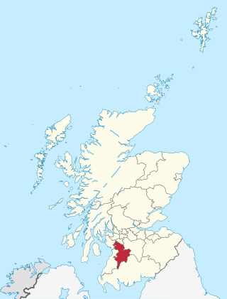
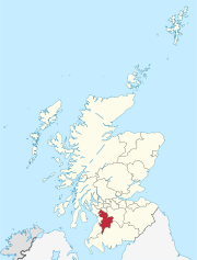
East Ayrshire is one of 32 unitary council areas of Scotland. It shares borders with Dumfries and Galloway, East Renfrewshire, North Ayrshire, South Ayrshire and South Lanarkshire. The headquarters of the council are located on London Road, Kilmarnock. With South Ayrshire and the mainland areas of North Ayrshire, it formed the former county of Ayrshire.

Loudoun is a parish in East Ayrshire, Scotland and lies between five and ten miles east of Kilmarnock. The parish roughly encompasses the northern half of the Upper-Irvine Valley and borders Galston Parish at the River Irvine.

<span class="mw-page-title-main">Kilmarnock and Loudoun (district)</span> Scottish district in East Ayrshire, Scotland, UK

Kilmarnock and Loudoun was one of nineteen local government districts in the Strathclyde region of Scotland from 1975 to 1996.

<span class="mw-page-title-main">Newmilns</span> Burgh (Newmilns and Greenholm) and Village in Scotland

Newmilns is a village in the burgh of Newmilns and Greenholm, in East Ayrshire, Scotland. It has a population of 3,057 people and lies on the A71, around seven miles east of Kilmarnock and twenty-five miles southwest of Glasgow. It is situated in a valley through which the River Irvine runs and, with the neighbouring towns of Darvel and Galston, forms an area known as the Upper Irvine Valley.

<span class="mw-page-title-main">Darvel</span> Town in Scotland

Darvel (Scots: Dairvel, Scottish Gaelic: Darbhail) is a small town in East Ayrshire, Scotland. It is at the eastern end of the Irvine Valley and is sometimes referred to as "The Lang Toon".

<span class="mw-page-title-main">Mauchline</span> Town and civil parish in East Ayrshire, Scotland

Mauchline is a town and civil parish in East Ayrshire, Scotland. In the 2001 census Mauchline had a recorded population of 4,105. It is home to the National Burns Memorial.

<span class="mw-page-title-main">River Irvine</span> River in southwest Scotland

The River Irvine is a river that flows through southwest Scotland. Its watershed is on the Lanarkshire border of Ayrshire at an altitude of 810 feet (250 m) above sea-level, near Loudoun Hill, Drumclog, and 7 miles SW by W of Strathaven. It flows 29+12 mi (47.5 km) westward, dividing the old district of Cunninghame from that of Kyle, until it reaches the sea via Irvine Harbour in the form of the Firth of Clyde, and flows into Irvine Bay by the town of Irvine. It has many tributaries, some of which form parish, district and other boundaries.

Riccarton is a village and parish in East Ayrshire, Scotland. It lies across the River Irvine from Kilmarnock, this river forming the boundary between Riccarton and Kilmarnock parishes, and also between the historical districts of Kyle and Cunningham. The name is a corruption of 'Richard's town', traditionally said to refer to Richard Wallace, the uncle of Sir William Wallace. The parish also contains the village of Hurlford.

<span class="mw-page-title-main">Roman Catholic Diocese of Galloway</span> Roman Catholic diocese in Scotland

The Diocese of Galloway is a Latin Church ecclesiastical territory or diocese of the Catholic Church in Scotland. The pre-Reformation Diocese of Galloway, founded by Ninian in the fifth century, had broken allegiance with Rome in 1560, and disappeared in 1689 in the (official) Church of Scotland but continued in the Episcopal Church of Scotland. The modern Roman Catholic diocese incorporates the local authority areas of Dumfries and Galloway, South Ayrshire, East Ayrshire and parts of North Ayrshire, (Cumbrae). The bishop's cathedra is at St Margaret's Cathedral, Ayr.

<span class="mw-page-title-main">Kilmarnock and Irvine Valley (Scottish Parliament constituency)</span> Region or constituency of the Scottish Parliament

Kilmarnock and Irvine Valley is a constituency of the Scottish Parliament (Holyrood) covering part of the council area of East Ayrshire. It elects one Member of the Scottish Parliament (MSP) by the plurality method of election. It is also one of nine constituencies in the South Scotland electoral region, which elects seven additional members, in addition to the nine constituency MSPs, to produce a form of proportional representation for the region as a whole.

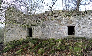
Loudoun Kirk is a disused church located about one mile west of Loudoun Castle, East Ayrshire. It served as Loudoun's parish church until some point after 1600, when this function moved to the church in nearby Newmilns. It subsequently fell into a state of disrepair, however since 1994 has been preserved by a local charity, Friends Of Loudoun Kirk.

<span class="mw-page-title-main">Alison Begbie</span>

Alison Begbie, Ellison Begbie or Elizabeth Gebbie (1762–1823), is said to have been the daughter of a farmer, born in the parish of Galston, and at the time of her courtship by Robert Burns she is thought to have been a servant or housekeeper employed at Carnell House, then known as Cairnhill, on the River Cessnock, situated about 2 miles from Loudoun Mill. It is thought that Burns's youngest sister Isobel Burns confused her name, which was really Elizabeth Gebbie.

Galston Parish is situated in East Ayrshire, Scotland, some five to ten miles east of Kilmarnock and roughly encompasses the southern half of the Upper Irvine Valley. The parish shares strong links with the parish of Loudoun, with which it shares a border along the River Irvine.

<span class="mw-page-title-main">Murder of Hugh Montgomerie</span>

The Murder of Hugh Montgomerie, 4th Earl of Eglinton at the Annick Ford in Stewarton, East Ayrshire, Scotland, took place in 1586 as a consequence of a long running feud between the Montgomeries, Earls of Eglinton and the Cunninghames, Earls of Glencairn, families who were competing for power and influence locally and nationally. The significant repercussions of this act were felt throughout the county of Ayrshire and beyond. The spelling 'Montgomerie' is used throughout for both the family and Montgomery for the clan and clan and district names 'Cunninghame' in the same fashion.

<span class="mw-page-title-main">Haining Place and the Barony of Haining-Ross</span>

Haining Place or The Haining in the Parish of Kilmarnock lies near an old fording place across the Cessnock Water in East Ayrshire, Parish of Riccarton, Scotland. Hanyng (sic) was the caput or laird's dwelling of the Barony of Haining-Ross with a tower house or keep located in a defensive position on a high promontory of land, half encircled by the river. Later Haining Place may have been a dower house, then a tenanted farm, finally being used as farm workers accommodation. Haining Place is now a ruin following a fire. The old farm of Haining Mains is still located nearby.

Cessnock Castle is a 15th-century keep greatly enlarged into a baronial mansion, about 1 mile (1.6 km) south east of Galston, East Ayrshire, Scotland, and 0.75 miles (1.21 km) south of the River Irvine.

The Lands of Dallars or Auchenskeith (NS463337) form a small estate in East Ayrshire, Hurlford, Kilmarnock, Parish of Riccarton, Scotland. The present mansion house is mainly late 18th-century, located within a bend of the Cessnock Water on the site of older building/s. "Dullers or Dillers" was changed to "Auchenskeith" or "Auchinskeigh" (sic) as well as other variants and then the name reverted nearer to the original form as "Dollars" and then finally "Dallars". Dallars lies 3.25 km south of Hurlford.

<span class="mw-page-title-main">Castle and Lands of Auchruglen</span> Scottish castle

The Castle and Lands of Auchruglen (NS5365436797) was a peel tower in the old district of Kyle held at different times by the Nesbitt and Campbell Clans and located near Newmilns, Parish of Galston, East Ayrshire, Scotland.

References

  1. "Mid-2020 Population Estimates for Settlements and Localities in Scotland". National Records of Scotland. 31 March 2022. Retrieved 31 March 2022.
  2. Scotland's Census Results OnLine Archived 2012-03-22 at the Wayback Machine
  3. Douglas, William Scott (1874). In Ayrshire. A Descriptive Picture of the County of Ayr. Kilmarnock : McKie & Drennan. Reprint. ISBN   978-1-4097-1645-7. p. 16
  4. Warrack, Alexander (1982)."Chambers Scots Dictionary". Chambers. ISBN   0-550-11801-2.
  5. "Galston Parish Church". 24 September 2017.
  6. Chambers, Robert (1885). Domestic Annals of Scotland. Edinburgh: Chambers. p. 188.
  7. "St Sophia's, Galston". 24 September 2017.
  8. Kyle, Thomas (1928). Burnawne Kilm Glenf Ramb Soc. Annals. 1919 - 1930. p. 126.
  9. MacIntosh, John (1894). Ayrshire Nights Entertainments: A Descriptive Guide to the History, Traditions, Antiquities, etc. of the County of Ayr. Pub. Kilmarnock. p. 11.
  10. 1 2 3 Irvine Valley Regeneration Partnership Accessed : 2009/12/05 Archived 2009-11-23 at the Wayback Machine
  11. 1 2 3 Campbell, Thorbjørn (2003). Ayrshire. A Historical Guide. Edinburgh : Birlinn. ISBN   1-84158-267-0. p. 142
  12. Protocol book of Gavin Ros, vol. 2, Scottish Record Society (1907) 187.
  13. St Peter in Chains Retrieved : 2010-11-18
  14. Travel Scotland - Galston. Accessed : 2009-12-05
  15. Scran - Handball. Accessed : 2009-12-05
  16. Galt, John (1895). Annals of the Parish and The Ayrshire Legatees. Edinurgh : William Blackwood & Sons. p. 265