Lefnoreis Castle

Last updated

Lefnoreis Castle
Cumnock, East Ayrshire, Scotland
UK grid reference NS 53908 20515
Leifnorris Castle site, Dumfries House, Ayrshire.jpg
The site of Lefnoreis or Ward of Lochnorris Castle
Scotland relief location map.jpg
Red pog.svg
Lefnoreis Castle
Coordinates 55°27′24″N4°18′43″W / 55.456614°N 4.3118274°W / 55.456614; -4.3118274
TypeTower
Site information
OwnerGreat Steward of Scotland Trust
Open to
the public
Yes
ConditionNo remnants
Site history
Built13th century
Built byCraufurds
In use13th to early 17th century
MaterialsStone

The site of the old Lefnoreis Castle [1] or Ward of Lochnorris [2] (NS 53908 20515) lies about 100 yards north-west of the old stable block of Dumfries House in East Ayrshire, Parish of Old Cumnock, Scotland. The old castle stood on a natural rise overlooking the Lugar Water, built and held for many years by the Craufurd family. [3] [4] For consistency the spelling Craufurd will be used throughout and Lefnoreis for the castle.

Contents

History

Lefnoreis is recorded as being the most important of the three castles in the parish of Old Cumnock, the other two being Borland Castle and Terringzean Castle. [4]

One recorded suggestion in regard of the occupied castle or fortified mansion is that two castles existed, one near the present day stables that was occupied until Dumfries House was built with its foundations still evident in 1885 and another that stood elsewhere on the estate that was abandoned before 1635 and of which no remains survive. [5]

The spelling of the placename

The name of the fortification is commonly recorded as variations of both Lefnoreis and Lochnorris with the former version more widely used on maps and many other variations in spelling and title, such as the Ward of Lefnorris, [6] Tower of Lefnoreis, [4] Lefnoreise, [7] Ward of Lochnoris, Lochnoreis, [1] Tower of Leifnorris, Liffnoris, Leifnoreis [8] and Lefnoryis. [1]

It is recorded on old maps as Lesno in the mid 17th century, [9] Castle of Lesno in 1654, [10] Lesnoris in 1685 [11] and finally as Lissnorris in 1747-1755. [12] It is also recorded as Craufurdstoun [13] as is the near by Terringzean Castle.

Considerable confusion has arisen in the writing of the castle's name arising from the use of the Long s to represent a lower case s in documents until around 1800 in printed documents and well into the 19th century for written documents. The convention previously being to use a letter similar to an elongated f, leading to a lower case s being easily and often confused and interpreted as an f. On the above mentioned maps this led to Lissnorris for example apparently having the spelling Liffnorris. An actual f had a short horizontal stroke to differentiate it. The intended pronunciation of the name might therefore be closer to Lesnories.

Ward

It is unusual for the term Ward to be applied to a fortification's name. In Scottish Law a Ward is "..the oldest form of feudal land tenure, viz. by military service, with various attendant rights and obligations, esp. that of the superior to uphold and draw the rents of the lands of a deceased vassal while the heir was uninfeft or remained a minor, as an equivalent for the loss of military services during such period, the usage being termed simple ward. Later commutation was admitted for a monetary payment in lieu of the drawing of rents." [14] This implies that the use of the name Ward only applied to periods in which the male heir was a minor, etc.

Description of the castle and lands

The 1671 Lefnoreis dovecote on the estate pre-dates Dumfries House. Dovecot at Dumfries House.jpg
The 1671 Lefnoreis dovecote on the estate pre-dates Dumfries House.

Paterson records that Lefnoreis was a tower known as the 'Ward'. [15] Lord Bute in 1897 carried out extensive excavations at the castle's site and discovered part of the walls of a fortification of considerable strength and also a causeway composed using water-worn stones. [6] In 1885 the foundations had still been visible above ground, the building being demolished circa 1759. [5] The old Lefnoreis walled garden stood near the recently restored Lady's Well (2018) that drains into the Lugar Water. [16]

The 1671 dated dovecote at Dumfries House (NS 53951 20350) is the oldest dated building on the estate and is contemporary with Lefnoreis Castle. [10] Another date of 1851 implies a restoration date. The armorial panel above the doorway is of the McDoualls of Freugh who in 1720 married into the Crichton family. [17]

To the west of the castle site and close to the site of the old Lefnoreis walled garden lies the recently restored Lady's Well (2018) that drains into the Lugar Water. 1756 is the first date recorded for the well although the well's name suggests a pre-reformation date that would make it contemporary with Leifnorris Castle. Until 1944 the well designed by Robert Adam stood as a small square structure with four arched openings and a pyramidal roof. [16]

The Craufurds also held lands in Ochiltree and Dalmellington. [8] The lands of Blackettle and Beauch were part of the lands of Lefnoreis. [18]

The Lairds of Lefnoreis

The site of the Lefnoreis Tower from near Dumfries House stables. Old Leifnorris Castle site, Dumfries House, Ayrshire.jpg
The site of the Lefnoreis Tower from near Dumfries House stables.
Arms of the Craufurds of Lefnoreis:Gules, a fess ermine, in chief two stars or. Crawford of Lochnorris arms.svg
Arms of the Craufurds of Lefnoreis:Gules, a fess ermine, in chief two stars or.

The first recorded lairds of Lefnoreis were the Craufurds in 1440, [2] a branch of the Craufurd family of Loudoun Castle near Galston. [8] On the third of October 1528 the laird of Leiffnoris was at Mauchline Castle in the company of the bailie of the Barony of Kylesmuir, Hugh Campbell and the lairds of Ardgowan, Haining, Caprington and Ochiltree. It was the eve of the annual Mauchline Fair. [19]

The estate belonged to the family until 1635 when it was purchased by William, 2nd Earl of Dumfries. His heiress, Penelope, married the second son of the 1st Earl of Stair and the Dumfries title passed into the Dalrymple family. The Crichton-Stuarts, Marquesses of Bute inherited Dumfries House and estate. [20]

The coat of arms of the Craufurds of Lefnoreis was "Gules, a Fess Ermine, and in Chief, two Stars. Or." [15] This translates from heraldic terminology as a shield with a red background with a band of ermine running horizontally across and two gold stars above the horizontal band.

Historical incidents

William Craufurd in 1510 was involved in the taking back of Loch Doon Castle from the Kennedy Clan. [1] In 1512 the same William was involved in the murder of the laird of Corsintoune (sic) at Cumnock Church. This may refer to Coursington near Motherwell. [1] In 1527 George Craufurd accompanied the Campbells of Loudoun in the ambush that led to the death of the Earl of Cassillis at Prestwick. [18]

In 1544 John Knox records that George Craufurd of Lefnoreis opposed the Scottish Protestant Reformation and joined the Bishop of Glasgow in attempting to prevent George Wishart, later a Protestant martyr, from preaching in Ayr. In doing so he stood against the Earl of Glencairn's and his supporters. In 1566 Knox records that the new Craufurd laird was a supporter of Protestantism. [7]

In 1550 Agnes Craufurd, the Lady of Lefnoreis, was abducted and carried away for some time by fellow Craufurds. It seems that her husband had died without an heir and following the abduction a George Craufurd inherited the lands and castle. [18]

Loch Doon Castle was taken from the Kennedy Clan by William Craufurd of Lefnoreis. Remains of Loch Doon castle, as relocated today - geograph.org.uk - 936512.jpg
Loch Doon Castle was taken from the Kennedy Clan by William Craufurd of Lefnoreis.

In 1578 George Craufurd of Lefnoreis was fined £2000 for allowing James Elliot, an infamous border's reiver, to escape from his custody at the castle. [8] In 1609 another George Craufurd of Lefnoreis was imprisoned in Blackness Castle for bearing arms and assisting fugitives. [7] In 1560 and 1572 George Craufurd sat in the Scottish parliament and in 1589 William Craufurd was appointed as a commissioner to ensure that all Jesuits were to leave the country for a month. [7]

In 1606 two servants of George Craufurd of Lefnoreis, George and Andrew McCubene, claimed that John and George Hervie of Skellingtoun Mill attacked them at the Cumnock Market, putting them in fear of their lives. The court took the view that the McCubenes were the aggressors even though the McCubenes had suffered physical injuries during the affray. [21]

In 1608 the Privy Council of Scotland issued an order that the Cunninghames of Caprington, Dalkeith and Auchincors were not to meet at Cumnock Church as violence was foreseen. The families were in dispute and elsewhere murders had taken place on the sabbath at churches. William Cunninghame of Caprington and his son and the laird of Lefnoreis and his son were to refrain from meeting with their men at the church or suffer a large fine, the order remaining in force until 1 April 1609. [22]

Dumfries House

William Dalrymple, 5th Earl of Dumfries, was responsible for commissioning John, Robert and James Adam to design and build Dumfries House between 1754–59, the old castle then being abandoned and the stone removed. [23] [5]

See also

Related Research Articles

<span class="mw-page-title-main">Cumnock</span> Town and former civil parish in Scotland

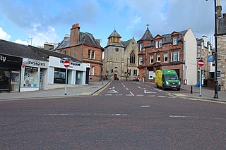
Cumnock is a town and former civil parish located in East Ayrshire, Scotland. The town sits at the confluence of the Glaisnock Water and the Lugar Water. There are three neighbouring housing projects which lie just outside the town boundaries, Craigens, Logan and Netherthird, with the former ironworks settlement of Lugar also just outside the town, contributing to a population of around 13,000 in the immediate locale. A new housing development, Knockroon, was granted planning permission on 9 December 2009 by East Ayrshire Council.

<span class="mw-page-title-main">Trabboch</span>

Trabboch is a hamlet in East Ayrshire, Scotland. Built as a miners village in the 1880s, it was owned and leased by Wm. Baird & Co., Ltd. and at one time had 94 dwellings. The miners rows stood, until demolition in 1969, on the Stair and Littlemill road, about two miles south of Stair, in that parish. The name is locally pronounced 'Traaboch'.

<span class="mw-page-title-main">Dule tree</span> Tree used as a gallows or gibbet in Britain

Dule trees, or dool trees, in Britain were used as gallows for public hangings. They were also used as gibbets for the display of the corpse for a considerable period after such hangings. These "trees of lamentation or grief" were usually growing in prominent positions or at busy thoroughfares, particularly at crossroads, so that justice could be seen to have been done and as a salutary warning to others. Place names such as Gallows-Hill, Gallows-See, Gallows-Fey and Hill of the Gallows record the site of such places of execution.

<span class="mw-page-title-main">Giffordland</span> Barony in North Ayrshire, United Kingdom

Giffordland is in North Ayrshire, Parish of Dalry (Cunninghame) in the former Region of Strathclyde, Scotland.

<span class="mw-page-title-main">Terringzean Castle, East Ayrshire</span>

Terringzean Castle, also Taringzean, pronounced 'Tringan', is a Category B listed castle ruin lying above the River Lugar and the Terringzean Holm in the policies of Dumfries House, Parish of Cumnock, Scotland. The name Craufordstone or Craufurdstoun, has also been used, echoing that it and these lands originally belonged to the Crawfords, as did Lefnoreis Castle or Lochnorris Castle which once stood near the site of the Dumfries House stables.

<span class="mw-page-title-main">Loch Fergus</span> Freshwater loch in South Ayrshire, Scotland

Loch Fergus is a freshwater post-glacial "Kettle Hole" sometimes recorded as Fergus Loch. It is quite visible and is situated in a low-lying area close to the B742 road between the farms and dwellings of Trees, Lochfergus and Bowmanston in the Parish of Ayr, South Ayrshire, Scotland. The loch lies to the north of Martnaham Loch, four miles east-southeast of Ayr. It drains to the southwest into the Snipe Loch.

<span class="mw-page-title-main">Kerse Castle, East Ayrshire</span>

Kerse Castle or Carse Castle is a ruined fortification once held by the Craufurd Clan, situated in the Parish of Dalrymple, East Ayrshire, Scotland.

<span class="mw-page-title-main">Auchencloigh Castle</span> Ruined fortification in the Parish of Ochiltree, East Ayrshire, Scotland

Auchencloigh Castle or Auchincloigh Castle is a ruined fortification near the Burnton Burn, lying within the feudal lands of the Craufurd Clan, situated in the Parish of Ochiltree, East Ayrshire, Scotland.

<span class="mw-page-title-main">Black Loch (New Cumnock)</span> Freshwater loch in East Ayrshire, Scotland

Black Loch is a freshwater loch, named from its dark waters, situated in the East Ayrshire Council Area, between Cumnock and New Cumnock, lying in a glacial Kettle Hole mainly within the Parish of New Cumnock, with a small portion protruding into Old Cumnock Parish. It is said to be one of only two lochs or lakes in the world that have outflows running to two separate destinations. The 'Runner' is a deep and broad ditch that was dug many years ago to link the three lochs of Lowes, Black, and Creoch.

<span class="mw-page-title-main">Kingencleugh Castle</span>

The remains of the old castle of Kingencleugh or Kingenclough lies close to east of the town of Mauchline, East Ayrshire, in the old Barony of Mauchline off the A76. The castle is Category B listed.

<span class="mw-page-title-main">Fairlie Castle</span> Castle in North Ayrshire, Scotland, UK

Fairlie Castle is a restored oblong tower castle located on a natural rounded knoll situated above a precipitous section of the Fairlie Glen near the town of Fairlie in the old Barony of Fairlie, Parish of Largs, North Ayrshire, Scotland. It was built by the now extinct family, the Fairlies of that Ilk and survives in a fairly good state of preservation. It is a protected scheduled monument.

<span class="mw-page-title-main">Lands of Borland, Barony of Cumnock</span> Human settlement in Scotland

The Lands of Borland or Boreland formed a castle and land holdings within the old Barony of Cumnock, East Ayrshire, Parish of Old Cumnock, Scotland. Lying two miles south of Cumnock the property was mainly held by a cadet branch of the Hamilton family from around 1400 before passing by marriage to the Montgomeries and others. For consistency the spelling 'Borland' will be used throughout.

<span class="mw-page-title-main">Wallace's Cave, Auchinleck</span>

Wallace's Cave in the Lugar Gorge at Auchinleck in the Parish of Auchinleck is an 18th-century grotto contemporary with Dr Johnson's Summerhouse, also located on the Auchinleck Estate. It shows superior workmanship in its construction, possibly being the enlargement of a pre-existing cave. The cave or grotto lies downstream of the confluence of the Dippol Burn with the River Lugar and is reached via a once well formed path, however access is now hazardous due to the condition of the cliff edge path and the vertical drop into the River Lugar.

What now survives of the old Caprington Loch (NS402352) is situated near Earlston, Riccarton, East Ayrshire, Scotland. The loch was a natural feature, sitting in a hollow on the old Caprington Castle estate. The loch waters drain via the Todrigs Burn that flows into the River Irvine to the east of Gatehead village. It was partly drained, probably sometime after the 1820s, as were so many other lochs, as part of 18th and 19th centuries extensive agricultural improvements and the only area of open water that remains does so as it was once used as a curling pond for the Caprington Castle Estate owners and their employees or tenants.

<span class="mw-page-title-main">Bickering Bush</span> Scottish thorn near Caprington, linked to legend of Sir William Wallace

The Bickering bush (NS41863635) thorn grew near Caprington on the lands of Monksholm or Maxholm, Riccarton, East Ayrshire, Scotland. The old farm house at Maxholm sat in hollow on the old Caprington Castle estate and to the north and west its fields bordered the River Irvine. The thorn was located, as recorded on the OS map, near to the confluence of the Kilmarnock Water and the River Irvine, downstream of the Simon's Burn's confluence on the south bank of the river.

<span class="mw-page-title-main">Minishant</span> Human settlement in Scotland

Minishant is a village bordering the A77 in the old county of Carrick, South Ayrshire, Scotland. It is located in Maybole Parish, 3+12 miles from Maybole and standing close to the River Doon. The village was originally named Culroy after the Culroy Burn that runs through it.

<span class="mw-page-title-main">Kyle Castle</span>

The ruins of the large courtyard style Kyle Castle, once also known as Cavil Castle or occasionally Dalblair Castle lie close to the hamlet of Dalblair in Auchinleck parish near Muirkirk in the East Ayrshire council area, Scotland. The castle stands at the confluence of the Guelt Water and the Glenmuir Water on a peninsula carved out by these rivers. Its name suggests that it was once of some significance.

<span class="mw-page-title-main">Castle and Barony of Gadgirth</span>

The Castle and Barony of Gadgirth was held by the Chalmer family, originally De Camera, with successive castles and a mansion house overlooking the River Ayr at the border of the Parish of Coylton, the old district of Kyle, now part of South Ayrshire, Scotland.

The Lands of Dallars or Auchenskeith (NS463337) form a small estate in East Ayrshire, Hurlford, Kilmarnock, Parish of Riccarton, Scotland. The present mansion house is mainly late 18th-century, located within a bend of the Cessnock Water on the site of older building/s. "Dullers or Dillers" was changed to "Auchenskeith" or "Auchinskeigh" (sic) as well as other variants and then the name reverted nearer to the original form as "Dollars" and then finally "Dallars". Dallars lies 3.25 km south of Hurlford.

<span class="mw-page-title-main">Castle and Lands of Auchruglen</span> Scottish castle

The Castle and Lands of Auchruglen (NS5365436797) was a peel tower in the old district of Kyle held at different times by the Nesbitt and Campbell Clans and located near Newmilns, Parish of Galston, East Ayrshire, Scotland.

References

Notes
  1. 1 2 3 4 5 James Paterson (1863). History of the counties of Ayr and Wigton. Vol.1 Kyle. James Stillie. p. 326.
  2. 1 2 Martin Coventry (2010). Castles of the Clans. Goblinshead. p. 130.
  3. Gordon W. Mason (2013). The Castles of Glasgow and the Clyde. Goblinshead. p. 118.
  4. 1 2 3 Rev John Warrick (1899). The History of Old Cumnock. Carn. p. 19.
  5. 1 2 3 A.H.Millar (1885). The Castles and Mansions of Ayrshire. The Grimsay Press. p. 70.
  6. 1 2 "Canmore - Dumfries House, Ward of Lochnorris" . Retrieved 27 August 2018.
  7. 1 2 3 4 Rev John Warrick (1899). The History of Old Cumnock. Carn. p. 21.
  8. 1 2 3 4 Rev John Warrick (1899). The History of Old Cumnock. Carn. p. 20.
  9. "Robert Gordon 1636-52. Cunningham" . Retrieved 27 August 2018.
  10. 1 2 "Coila Provincia (The province of Kyle). Timothy Pont. Blaeu 1654" . Retrieved 27 August 2018.
  11. "A mape of the west of Scotland containing Clydsdail, Nithsdail, Ranfrew, Shyre of Ayre, & Galloway / authore Jo. Adair. 1650-1722" . Retrieved 27 August 2018.
  12. "Roy Military Survey of Scotland, 1747-1755" . Retrieved 27 August 2018.
  13. "Clan Crawford Association" . Retrieved 27 August 2018.
  14. "Dictionary of the Scots Language" . Retrieved 28 August 2018.
  15. 1 2 James Paterson (1863). History of the counties of Ayr and Wigton. Vol.1 Kyle. James Stillie. p. 331.
  16. 1 2 "Canmore - Dumfries House, Lady's Well" . Retrieved 27 August 2018.
  17. "Canmore - Dumfries House, Dovecote" . Retrieved 27 August 2018.
  18. 1 2 3 James Paterson (1863). History of the counties of Ayr and Wigton. Vol.1 Kyle. James Stillie. p. 327.
  19. Sanderson, Margaret H.B. (1975). The Mauchline Account Books of Melrose Abbey 1527 - 1528. AANHS. p.93
  20. Martin Coventry (2010). Castles of the Clans. Goblinshead. p. 558.
  21. Rev John Warrick (1899). The History of Old Cumnock. Carn. p. 50.
  22. Rev John Warrick (1899). The History of Old Cumnock. Carn. p. 49.
  23. Martin Coventry (2010). Castles of the Clans. Goblinshead. p. 141.
Sources