Haulover Creek

Last updated
Haulover Creek
Haulover-creek.jpg
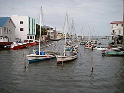
Haulover Creek littered by traditional wooden fishing boats
Location
Country Belize
Physical characteristics
Source 
  locationConfluence of Belize River and Bourdon Canal
  coordinates 17°29′N88°11′W / 17.483°N 88.183°W / 17.483; -88.183
Mouth  
  location
Caribbean Sea at Belize City
  coordinates
17°32′N88°14′W / 17.533°N 88.233°W / 17.533; -88.233 Coordinates: 17°32′N88°14′W / 17.533°N 88.233°W / 17.533; -88.233
Basin size Caribbean Sea

Haulover Creek is a coastal stream that runs through the center of Belize City and discharges into the Caribbean Sea. It is known for being the inlet of the Belize River, and separating the northern and southern areas of Belize City. [1] [2] There are multiple bridges built across it such as the Swing Bridge (Belize), which is the oldest of its kind in Central America, and the Belcan Bridge, which is used as the finishing line for the annual La Ruta Maya river challenge.

Contents

History

This creek has been used by fishing boats to easily access the center of Belize City and the Caribbean Sea. The creek still hosts the fleet of traditional fishing wooden boats (mostly from Sarteneja, Chunox and Copper bank) moored on posts to this present day (while the remaining Belize city wooden boats known as "sandlighters" that used to dock here now anchor in the north coast of Belize city). Its name is believed to be attained from those who had to "haul" their cattle over the creek with ropes prior to the construction of the swing bridge in 1922. [3] The creek is now famously used for easily accessing the Caribbean Sea from the city as observed by the hosting of the water taxi to distant islands such as San Pedro and Ambergris Caye, and the sighting of many fishing boats anchored in the stream.

Pollution and flooding

Haulover Creek is a noted high risk area for flooding and water pollution in Belize City. [4] [5] [6]

See also

Related Research Articles

Belize City Largest city in Belize

Belize City is the largest city in Belize and was once the capital of the former British Honduras. According to the 2010 census, Belize City has a population of 57,169 people in 16,162 households. It is at the mouth of the Haulover Creek, which is a distributary of the Belize River. The Belize River empties into the Caribbean Sea five miles from Belize City on the Philip Goldson Highway on the coast of the Caribbean. The city is the country's principal port and its financial and industrial hub. Cruise ships drop anchor outside the port and are tendered by local citizens. The city was almost entirely destroyed in October 1961 when Hurricane Hattie swept ashore. It was the capital of British Honduras until the government was moved to the new capital of Belmopan in 1970.

River Camel

The River Camel is a river in Cornwall, England, United Kingdom. It rises on the edge of Bodmin Moor and with its tributaries its catchment area covers much of North Cornwall. The river flows into the eastern Celtic Sea between Stepper Point and Pentire Point having covered about 30 miles, making it the second longest river wholly in Cornwall. The river is tidal upstream to Egloshayle and is popular for sailing, birdwatching and fishing. The name Camel comes from the Cornish language for 'the crooked one', a reference to its winding course. Historically the river was divided into three named stretches. Heyl was the name for the estuary up to Egloshayle, the River Allen was the stretch between Egloshayle and Trecarne, whilst the Camel was reserved for the stretch of river between its source and Trecarne.

Ballard Locks United States historic place

The Hiram M. Chittenden Locks, or Ballard Locks, is a complex of locks at the west end of Salmon Bay, in Seattle, Washington's Lake Washington Ship Canal, between the neighborhoods of Ballard to the north and Magnolia to the south.

Rahway River River in the United States

The Rahway River is a river in Essex, Middlesex, and Union Counties, New Jersey, United States, The Rahway, along with the Elizabeth River, Piles Creek, Passaic River, Morses Creek, the Fresh Kills River, has its river mouth at the Arthur Kill.

Trinity River (Texas) River in Texas, United States

The Trinity River is a 710-mile-long (1,140 km) river in Texas, and is the longest river with a watershed entirely within the U.S. state of Texas. It rises in extreme northern Texas, a few miles south of the Red River. The headwaters are separated by the high bluffs on the southern side of the Red River.

Hawkesbury River

The Hawkesbury River, is a semi–mature tide dominated drowned valley estuary located to the west and north of Sydney, New South Wales, Australia. The Hawkesbury River and its associated main tributary, the Nepean River, almost encircles the metropolitan region of Sydney.

River Torrens River in Australia

The River Torrens, is the most significant river of the Adelaide Plains. It was one of the main reasons for the siting of the city of Adelaide, capital of South Australia. It flows 85 kilometres (53 mi) from its source in the Adelaide Hills near Mount Pleasant, across the Adelaide Plains, past the city centre and empties into Gulf St Vincent between Henley Beach South and West Beach. The upper stretches of the river and the reservoirs in its watershed supply a significant part of the city's water supply.

Mersey River (Tasmania)

The Mersey River is a river on the north-west coast of Tasmania, Australia. The city of Devonport is situated at the river's mouth on Bass Strait.

River Esk, North Yorkshire

The River Esk is a river in North Yorkshire, England that empties into the North Sea at Whitby after a course of around 28 miles (45 km) through the valley of Eskdale, named after the river itself. The Esk is the only major river in Yorkshire that flows directly into the North Sea; all other watercourses defined as being major rivers by the Environment Agency, either flow to the North Sea via the River Tees or the Humber Estuary.

Hurricane Iris Category 4 Atlantic hurricane in 2001

Hurricane Iris was a small, but powerful tropical cyclone that caused widespread destruction in Belize. Iris was the second-strongest storm of the 2001 Atlantic hurricane season, behind Hurricane Michelle. It was the ninth named storm, fifth hurricane, and third major hurricane of the year, forming from a tropical wave on October 4 just southeast of Barbados. It moved westward through the Caribbean, intensifying into a tropical storm on October 5 south of Puerto Rico, and into a hurricane on the following day. While passing south of the Dominican Republic, Iris dropped heavy rainfall that caused landslides, killing eight people. Later, the hurricane passed south of Jamaica, where it destroyed two houses. On reaching the western Caribbean Sea, Iris rapidly intensified into a Category 4 on the Saffir–Simpson scale. A small hurricane with an eye of only 7 mi (11 km) in diameter, Iris reached peak winds of 145 mph (230 km/h) before making landfall in southern Belize near Monkey River Town on October 9. The hurricane quickly dissipated over Central America, although its remnants contributed to the formation of Tropical Storm Manuel in the eastern Pacific Ocean. The hurricane caused severe damage—destroying homes, flooding streets, and leveling trees—in coastal towns south of Belize City.

Esopus Creek Tributary of the Hudson River in the Catskill region of New York state

Esopus Creek is a 65.4-mile-long (105.3 km) tributary of the Hudson River that drains the east-central Catskill Mountains in the U.S. state of New York. From its source at Winnisook Lake on the slopes of Slide Mountain, the Catskills' highest peak, it flows across Ulster County to the Hudson at Saugerties. Many tributaries extend its watershed into neighboring Greene County and a small portion of Delaware County. Midway along its length, it is impounded at Olive Bridge to create Ashokan Reservoir, the first of several built in the Catskills as part of New York City's water supply system. Its own flow is supplemented 13 miles (21 km) above the reservoir by the Shandaken Tunnel, which carries water from the city's Schoharie Reservoir into the creek.

Albert (Belize House constituency)

Albert is an electoral constituency in the Belize District of Belize.

Burdon Canal Nature Reserve

The Burdon Canal Nature Reserve in Belize is a low-lying basin, comprising the backswamps of the Belize River/Haulover Creek delta. It is permanently waterlogged, with a gradient of saline to fresh water arising from regular tidal inundation at the seaward fringe and freshwater flooding from inland. During the dry season, parts of the reserve may become hypersaline. The site's elevation is generally sea level, but rises to approximately 4 ft (1.2 m) along river banks. It receives approximately 75 inches (1,900 mm) to 80 inches (2,000 mm) of rain per year. The tide in the Canal is semi-diurnal, and the water level at the Canal Bridge lags about 2-3 hours behind the centre of Belize City.

Sarteneja Village in Corozal District, Belize

Sarteneja is the largest fishing community and the second largest village in Belize. It recorded a population of 3,500 according to a 2016 estimate. The name Sarteneja is a Castilian distortion of its original Mayan name Tza-ten-a-ha, which means 'water between the rocks'.

Tropical Storm Arthur (2008)

Tropical Storm Arthur was the first Atlantic tropical storm that formed during the month of May since 1981. The first tropical cyclone of the 2008 Atlantic hurricane season, the storm formed on May 30, 2008 from the interaction of two tropical waves and the remnants of the eastern Pacific Tropical Storm Alma, which had crossed into the western Caribbean Sea. The system quickly organized and was named Tropical Storm Arthur on May 31, while crossing the shore of Belize. It dissipated two days later over the Yucatán Peninsula in Mexico. Arthur and its remnants triggered severe flooding which killed a reported nine people and affected 100,000 more in Belize. Damage was light to moderate, estimated at $78 million (2008 USD).

Wilsons River (New South Wales)

Wilsons River, a perennial river and part of the Richmond River catchment, is situated in the Northern Rivers district of New South Wales, Australia.

Hawkesworth Bridge

Hawkesworth Bridge is a one lane suspension bridge in San Ignacio, Belize. Built in 1949 and imported from Middlesbrough, England, it crosses the Macal River linking San Ignacio to its sister-town Santa Elena. It is currently the only drivable suspension bridge in Belize. Work began in October 2012 on a new, larger bridge that will link Santa Elena and San Ignacio that will span 154 meters across the Macal River.

Swing Bridge (Belize)

The Belize City Swing Bridge is a swing bridge located in downtown Belize City, Belize. It connects the north side of Belize City with the south side and spans Haulover Creek, a tributary of the Belize River.

Adyar River

The Adyar or Adayar, originating near the Chembarambakkam Lake in Kanchipuram district, is one of the three rivers which winds through Chennai (Madras), Tamil Nadu, India, and joins the Bay of Bengal at the Adyar estuary. The 42.5-kilometre (26.4 mi) long river contributes to the estuarine ecosystem of Chennai. Despite the high pollution levels, boating and fishing take place in this river. The river collects surplus water from about 200 tanks and lakes, small streams and the rainwater drains in the city, with a combined catchment area of 860 square kilometres (331 sq mi). Most of the waste from the city is drained into this river and the Cooum.

Bullet Tree Falls Place in Cayo District, Belize

Bullet Tree Falls is a village located along the Mopan River in Cayo District, Belize. It lies approximately five kilometers northwest of San Ignacio. According to the 2010 census, Bullet Tree Falls has a population of 2,124 people in 426 households. The population consists mainly of Spanish-speaking mestizos, along with a smaller number of Yucatec Maya and Creoles.

References

  1. "Belize City". Encyclopedia Britannica. Retrieved 12 October 2017.
  2. "Belize City Travel - Lonely Planet". Lonely Planet. Retrieved 12 October 2017.
  3. "Haulover Creek, Belize City". mygola. Retrieved 12 October 2017.
  4. "Belize Flood Risk" (PDF). Retrieved 12 October 2017.
  5. "Siltation, And Other Hydraulic Problems". 7 News Belize. July 13, 2016. Retrieved 12 October 2017.
  6. "Raw Sewage Pumped into Haulover Creek Causes Public Uproar". 7 News Belize. February 7, 2017. Retrieved 20 October 2017.