Hawksworth, Leeds

Last updated

Hawksworth
Hawkie099.JPG
The Broadway, Hawksworth
Leeds UK location map.svg
Red pog.svg
Hawksworth
West Yorkshire UK location map.svg
Red pog.svg
Hawksworth
Location within West Yorkshire
OS grid reference SE254369
Metropolitan borough
Metropolitan county
Region
Country England
Sovereign state United Kingdom
Post town LEEDS
Postcode district LS5
Police West Yorkshire
Fire West Yorkshire
Ambulance Yorkshire
UK Parliament
List of places
UK
England
Yorkshire
53°49′48″N1°36′47″W / 53.830°N 1.613°W / 53.830; -1.613 Coordinates: 53°49′48″N1°36′47″W / 53.830°N 1.613°W / 53.830; -1.613

Hawksworth is a small, early twentieth-century council estate in the Kirkstall ward in Leeds, West Yorkshire, England.

Contents

It is situated on a hill between West Park and Horsforth and is circled by Butcher Hill, the A65 and Vesper Road. Hawksworth lies within the LS5 Kirkstall postcode area and is commonly known as The Hawk, The Hawky or The Hawky Estate.

Etymology

The name Hawksworth appears to have been given to the estate as recently as its foundation in the twentieth century, and is not covered by the relevant English Place Name Society surveys. [1] The name also belongs to the ancient village of Hawksworth five miles away and may have been transferred to the Hawksworth estate from there.[ citation needed ]

The name Hawksworth Wood probably refers to the wood that stood to the west of Kirkstall Abbey. It provided shelter, fuel, pannage and building resources such as thatch for the abbey; timber was generally brought from elsewhere since Alexander, the founding abbot of Kirkstall who completed the initial building work, was concerned to preserve the woodland at Hawksworth.[ citation needed ]

History

After the First World War, councils were encouraged to build 'Homes fit for Heroes', and by 1930 7,000 new council houses had been built in Leeds, on estates which included the Hawksworth Wood.

The woodland around the Hawksworth estate lies within the framework of the Upper Aire Valley. Parts of these sites were formerly quarried or gleaned for millstone grit but have now reverted to woodland and scrub.

The woodlands are predominantly mixed broadleaves mainly containing oak and sycamore, with the understories consisting of rowan, hazel, holly and guelder rose. Small pockets of heather can also be found. These woodlands provide considerable colour and diversity to this suburban and formerly industrial area and are currently managed to ensure a continuity of multi-aged tree cover. Great Hawksworth has received active management in recent years through the removal of invasive tree species and the promotion of understorey and ground flora.

St. Marys Church St Marys Church, Hawksworth, Leeds.jpg
St. Marys Church

Another interesting fact concerning the area is that the 1933 Penny of George V, a classic rarity, had been placed under the foundation stone of St. Mary's Church in the area. Most accounts indicate that a mere seven pieces were struck for special presentation purposes, and only three currently reside in private collections. In 1933 there was no requirement for the Royal Mint to produce any pennies because there were already enough in circulation. Requests were, however, received for sets of coins dated 1933 to be placed under the foundation stones of buildings erected in that year, and the Mint obliged by striking a small number of coins. The result was to create a rarity that many people thought could turn up in their change.

Reports indicate that in 1970, during construction at Church of St. Cross, Middleton, one of these examples was stolen. In response, the Bishop of Ripon ordered that the St. Mary's Church 1933 Penny be unearthed and sold as a protective measure to prevent its theft.

Numerous public rights of way run through the woods which are accessible via Butcher Hill, Hawksworth Road, New Road Side, Abbey Road, Vesper Road, Cragside Walk and Cragside Close.

There is a metal hatch in Hawksworth Woods which is actually the entrance to an old explosives store from when the woods were once quarried for stone. It has been mistaken for a Second World War shelter.[ citation needed ]

Facilities

Hawksworth contains various different stores, including a Co-op, LloydsPharmacy and two small Premier stores. Other facilities include various independent takeaway stores, hairdressing salons and a charity shop.

A Post Office facility was situated on Broadway, however was eventually closed down due to lack of staff willing to operate the premises. [2] An intregreted Premier store has since taken over responsibility of main Post Office functions. However, as of July 2021, the postbox outside the previous Broadway premises still remains in use.

Previously there was a pub on Vesper Road titled The Woodway, however this was closed in the 1990s. [3]

Education

Primary Education

Hawksworth Wood Primary School is the sole primary school on the estate. The school was split into two during the 1970s into Hawksworth Wood Primary and Vesper Gate Middle School. Vesper Gate Middle School has since been redeveloped into Hawksworth Wood Children's Centre. On opening, the children's centre included an adult education facility run by Leeds City College however this closed soon after.

Secondary Education

Hawksworth does not contain any secondary education facilities itself. However, there are numerous secondary schools around the area where residents may attend, including Abbey Grange Church of England Academy, Lawnswood School and Horsforth School.

Culture

An episode of TV series A Touch of Frost named "Held in Trust", released in 2003, had some scenes filmed at Hawksworth Primary School.

See also

Related Research Articles

<span class="mw-page-title-main">Kirkstall</span> Suburb of Leeds, West Yorkshire, England

Kirkstall is a north-western suburb of Leeds, West Yorkshire, England, on the eastern side of the River Aire. The area sits in the Kirkstall ward of Leeds City Council and Leeds West parliamentary constituency, represented by Rachel Reeves. The population of the ward at the 2011 Census was 21,709.

<span class="mw-page-title-main">Horsforth</span> Town and civil parish in West Yorkshire, England

Horsforth is a town and civil parish in the City of Leeds, West Yorkshire, England, five miles north-west of Leeds city centre. Historically a village within the West Riding of Yorkshire, it had a population of 18,895 at the 2011 Census. It became part of the City of Leeds metropolitan borough in 1974. In 1999, a civil parish was created for the area, and the parish council voted to rename itself a town council. The area is within the Horsforth ward of Leeds City Council, which also includes the southern part of Rawdon.

<span class="mw-page-title-main">Roundhay</span> Suburb of Leeds, West Yorkshire, England

Roundhay is a large suburb in north-east Leeds, West Yorkshire, England. Roundhay had a population of 22,546 in 2011.

<span class="mw-page-title-main">Cookridge</span> Suburb of Leeds in West Yorkshire, England

Cookridge is a suburb of north-west Leeds, West Yorkshire, England, north of the Leeds Outer Ring Road. In 1715 Ralph Thoresby described it as a village four miles from Leeds and three from Otley, dating from 1540.

<span class="mw-page-title-main">West Park, Leeds</span> Human settlement in England

West Park is a suburb of north-west Leeds, West Yorkshire, England, north of Headingley. It is a mixed area of private suburban housing and suburban council estates. The name derives from its main park containing playing fields together with a conservation area of grassy meadow ending in woodland. The largest housing estate in West Park is Moor Grange.

<span class="mw-page-title-main">Woodhouse, Leeds</span>

Woodhouse is a largely residential area just north of the city centre of Leeds and close to the University of Leeds. It is in the Hyde Park and Woodhouse ward of City of Leeds metropolitan district. The population of the ward at the 2011 Census was 25,914.

<span class="mw-page-title-main">Ireland Wood</span>

Ireland Wood is a small residential area in north-west Leeds, West Yorkshire, England named after the Woodland Trust wood which it contains. It is approximately 4 miles (6.4 km) to the north-west of Leeds city centre. It was planned by Leeds Housing Director RAH Livett and won the Ministry Housing medal for 1945-9. An early plan of Ireland Wood in 1950 is shown on the Leodis website.

<span class="mw-page-title-main">Rawdon, West Yorkshire</span> Village and civil parish in West Yorkshire, England

Rawdon is a village and civil parish in the metropolitan borough of the City of Leeds, West Yorkshire, England. It sits on the River Aire and on the A65 south of Yeadon.

<span class="mw-page-title-main">Headingley railway station</span> Railway station in West Yorkshire, England

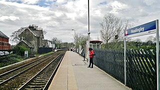
Headingley railway station is off Kirkstall Lane in Leeds, West Yorkshire, England, on the Harrogate Line, 3 miles (5 km) north west of Leeds. The station was opened in 1849 by the Leeds & Thirsk Railway, later part of the Leeds Northern Railway to Northallerton.

<span class="mw-page-title-main">Moor Grange</span> Human settlement in England

Moor Grange Estate is a housing estate in the West Park area of Leeds, West Yorkshire, England, which was built in the 1950s on reclaimed farmland. Work on the Moor Grange Estate began in 1955. It was originally owned by the local council, and was leased by the council to tenants as a council estate. Most of the housing on the estate is now privately owned. Moor Grange does not suffer the crime problems of other council estates. House prices on the estate are high, and Moor Grange is considered a 'model council estate'. This may be due to the affluence of the area in which it is situated. Moor Grange backs onto the smaller Spen Estate which is another council estate in West Park. The Estate falls within the Kirkstall ward of the Leeds Metropolitan Council.

<span class="mw-page-title-main">Shadwell, West Yorkshire</span> Village and civil parish in West Yorkshire, England

Shadwell is a village and civil parish in north-east Leeds, West Yorkshire, England. The village is 6 miles (9.7 km) to the north east of Leeds city centre.

<span class="mw-page-title-main">Richmond Hill, Leeds</span> Human settlement in England

Richmond Hill is a district of Leeds, West Yorkshire, England. The district lies a mile to the east of the city centre between York Road, East End Park and Cross Green. The appropriate City of Leeds ward is Burmantofts and Richmond Hill.

<span class="mw-page-title-main">Burley, Leeds</span> Area of Leeds, West Yorkshire, England

Burley is an inner city area of Leeds, West Yorkshire, England, 1 mile (1.6 km) north-west of Leeds city centre, between the A65 Kirkstall Road at the south and Headingley at the north, in the Kirkstall ward.

<span class="mw-page-title-main">Beckett Park</span> Residential area and a large public park in Leeds, West Yorkshire, England

Beckett Park is a residential area and a large public park in Leeds, West Yorkshire, England. It is in the Weetwood ward of Leeds City Council. It borders onto Headingley, West Park and Kirkstall. It is named after Ernest Beckett, 2nd Baron Grimthorpe.

<span class="mw-page-title-main">Architecture of Leeds</span> Buildings of Leeds, West Yorkshire, England

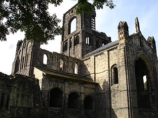
The architecture of Leeds, a city and metropolitan borough in West Yorkshire, England, encompasses a wide range of architectural styles and notable buildings. As with most northern industrial centres, much of Leeds' prominent architecture is of the Victorian era. However, the City of Leeds also contains buildings from as early as the Middle Ages such as Kirkstall Abbey, one of Britain's best preserved ruined Cistercian monasteries, as well as examples of 20th century industrial architecture, particularly in the districts of Hunslet and Holbeck.

<span class="mw-page-title-main">Kirkstall Forge</span>

Kirkstall Forge is a 57-acre mixed-use development located in Kirkstall in Leeds, West Yorkshire. The site is one of the oldest most continuously used industrial sites in England. It was operated by Kirkstall Forge Engineering, a metalworking business. It was a working forge until 1995 when the site was bought by Commercial Estates Group who have had plans approved to build 1,050 homes, 300,000 sq ft of office space, 100,000 sq ft of leisure and retail and a primary school. In June 2016 a railway station was opened on the site served by trains between Leeds and Bradford.

<span class="mw-page-title-main">Chapel Allerton</span> Suburb of Leeds in West Yorkshire, England

Chapel Allerton is an inner suburb of north-east Leeds, West Yorkshire, England, 2 miles (3.2 km) from the city centre.

Kirkstall is a ward in the metropolitan borough of the City of Leeds, West Yorkshire, England. It contains 48 listed buildings that are recorded in the National Heritage List for England. Of these, one is listed at Grade I, the highest of the three grades, two are at Grade II*, the middle grade, and the others are at Grade II, the lowest grade. The ward contains Kirkstall, Burley and Hawksworth, all suburbs of Leeds. The River Aire and the Leeds and Liverpool Canal pass through the ward, and the listed buildings associated with these are weirs, sluices, locks, and a canal bridge. The most important building is the ward is Kirkstall Abbey, which is listed, together with associated structures. The other listed buildings include houses and associated structures, churches and items in churchyards, public houses, a school and a former Sunday school, a commemorative arch, road bridges, a railway viaduct and station, former mill buildings, buildings associated with a former forge, and a war memorial.

<span class="mw-page-title-main">Newlay</span> Suburb of Horsforth, West Yorkshire, England

Newlay is a suburb of Horsforth, in West Yorkshire, England. Originally a hamlet, it is now part of Horsforth parish in the City of Leeds District, and has its own conservation area. Newlay is situated on the Leeds and Liverpool Canal and the River Aire, some 5 miles (8 km) north west of Leeds city centre.

References

  1. Harry Parkin, Your City's Place-Names: Leeds, English Place-Name Society City-Names Series, 3 (Nottingham: English Place-Names Society, 2017), pp. 52–53.
  2. "Leeds residents launch campaign to save estate post office". The Guardian. 9 November 2010. Retrieved 13 July 2021.
  3. "The Woodway, Leeds". www.closedpubs.co.uk. Retrieved 13 July 2021.