
Kew Gardens is a Grade II–listed London Underground and London Overground station in Kew, in the London Borough of Richmond upon Thames. It first opened in 1869 and is now managed by London Underground. The station, which is in Travelcard Zones 3 and 4, is served by both the District line on the London Underground and the North London line on the London Overground, and is situated midway between Gunnersbury and Richmond stations.
Hawthorn is an inner suburb of Melbourne, Victoria, Australia, 6 kilometres (3.7 mi) east of Melbourne's central business district, located within the City of Boroondara local government area. Hawthorn recorded a population of 22,322 at the 2021 census.

Caulfield is a suburb in Melbourne, Victoria, Australia, 10 kilometres (6.2 mi) south-east of Melbourne's Central Business District, located within the City of Glen Eira local government area. Caulfield recorded a population of 5,748 at the 2021 census.

A rail trail is a shared-use path on railway right of way. Rail trails are typically constructed after a railway has been abandoned and the track has been removed but may also share the right of way with active railways, light rail, or streetcars, or with disused track. As shared-use paths, rail trails are primarily for non-motorized traffic including pedestrians, bicycles, horseback riders, skaters, and cross-country skiers, although snowmobiles and ATVs may be allowed. The characteristics of abandoned railways—gentle grades, well-engineered rights of way and structures, and passage through historical areas—lend themselves to rail trails and account for their popularity. Many rail trails are long-distance trails, while some shorter rail trails are known as greenways or linear parks.

Salford Crescent railway station is a railway station in Salford, Greater Manchester, England, opened by British Rail in 1987.

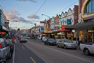
Glenferrie Road is a major north–south thoroughfare in Melbourne, Australia. It runs from Kew to Caulfield North, and includes major shopping districts at both Hawthorn and Malvern. There are a number of rail transport options on Glenferrie Road and also some landmarks.
The Kew railway line was a former railway line in Melbourne, Australia. The line ran from Hawthorn to Kew. It was opened on 19 December 1887 and was officially closed on 13 May 1957. The last train ran on 18 August 1952 after years of decline.
The Purple Line is a 16.2-mile (26.1 km) light rail line being built to link several Maryland suburbs of Washington, D.C.: Bethesda, Silver Spring, College Park, and New Carrollton. Currently slated to open in late 2027, the line will also enable riders to move between the Maryland branches of the Red, Green, and Orange lines of the Washington Metro without riding into central Washington, and between all three lines of the MARC commuter rail system. The project is administered by the Maryland Transit Administration (MTA), an agency of the Maryland Department of Transportation (MDOT), and not the Washington Metropolitan Area Transit Authority (WMATA), which operates Metro.

The Capital Crescent Trail (CCT) is a 7.04-mile (11.33 km), shared-use rail trail that runs from Georgetown in Washington, D.C., to Bethesda, Maryland. An extension of the trail from Bethesda to Silver Spring along a route formerly known as the Georgetown Branch Trail is being built as part of the Purple Line light rail project.

The Dalecarlia Tunnel in Brookmont, Maryland, near Washington, D.C., is a former railroad tunnel that presently carries the Capital Crescent Trail underneath MacArthur Boulevard and the Washington Aqueduct.

The Schuylkill River Trail is a multi-use trail along the banks of the Schuylkill River in southeastern Pennsylvania. Partially complete as of 2018, the trail is ultimately planned to run about 140 miles (230 km) from the river's headwaters in Schuylkill County to Fort Mifflin in Philadelphia.

The Syndal Heatherdale Pipe Reserve Trail is a shared use path for cyclists and pedestrians, which follows the Syndal to Heatherdale pipe reserve in the eastern suburbs of Melbourne, Victoria, Australia.
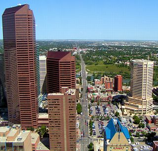
Centre Street is a major road in Calgary, Alberta, and defines the east and west halves of the city for the purposes of street addresses.

The Yarra River is a river in southern Victoria, Australia that flows through the city of Melbourne. There are many parklands, including state parks and national parks, that adjoin the river along its 250 km length. Every park listed has walking tracks, smaller parks usually have unsealed paths, while bigger parks will have sealed pathways suitable for walking and cycling. The Yarra River Trail runs along much of the length of the river's lower reaches through Melbourne. Most parks listed have parking available, the quality and quantity of which varies according to the size of the park. Dogs are not permitted in parklands adjoining the river unless otherwise stated in special off-lead areas.
The Seattle and North Coast Railroad (SNCT) was a short-line railroad that operated on the northern part of the Olympic Peninsula in Washington State from Port Angeles to Port Townsend. The line was unique in that it was a "rail island" with no outside rail connection to a mainline railroad. Instead, rail equipment was brought in via barges that traveled between Port Townsend and Seattle.
Yale Heights is a neighborhood in the Southwest District of Baltimore, located between Beechfield (west) and Irvington (east). Most of its homes were built in 1955 as a development of two-bedroom, brick townhouses. Its population in 2008 was estimated at 2,916.

The DL class is a class of diesel locomotives built by Queensland Railways, Robert Stephenson and Hawthorns and Walkers Limited for Queensland Railways between 1939 and 1961.
The Melbourne tram network began in 1884 with the construction of the Fairfield Horse Tramway. However, the purpose of the line was to increase land prices in the area, and it soon closed during the depression in 1890. The first genuine attempt to construct a tramway network was the construction of the Richmond cable tram line by the Melbourne Tramway & Omnibus Company in 1885. Over the next few years, 16 more cable tram lines were constructed, as well as numerous other horse tramways. The depression of the early 1890s slowed further expansion of the cable network. The first electric tram line was the Box Hill and Doncaster tramway which opened in 1889. This was a pioneering line in what was then the countryside and thus didn't receive much patronage. It closed in 1896. The next attempt at an electric tramway was Victorian Railways' St Kilda to Brighton line, which opened in 1906. Later that year, the North Melbourne Electric Tramway & Lighting Company opened lines to Essendon and Maribyrnong. Many local councils formed their own tramway trusts and built tramways within their own constituency. The most successful of these was the Prahran & Malvern Tramways Trust.
The Djerring Trail is a shared use path that runs alongside the Cranbourne and Pakenham railway lines in south-eastern Melbourne, Australia. The route serves a total of 13 railway stations.
