A railroad switch (AE), turnout, or [set of] points (BE) is a mechanical installation enabling railway trains to be guided from one track to another, such as at a railway junction or where a spur or siding branches off.

A rail trail is a shared-use path on railway right of way. Rail trails are typically constructed after a railway has been abandoned and the track has been removed, but may also share the right of way with active railways, light rail, or streetcars, or with disused track. As shared-use paths, rail trails are primarily for non-motorized traffic including pedestrians, bicycles, horseback riders, skaters, and cross-country skiers, although snowmobiles and ATVs may be allowed. The characteristics of abandoned railways—gentle grades, well-engineered rights of way and structures, and passage through historical areas—lend themselves to rail trails and account for their popularity. Many rail trails are long-distance trails, while some shorter rail trails are known as greenways or linear parks.
Rokeby is a suburb of Hobart, capital of Tasmania, Australia on the eastern shore of the Derwent River. It is part of the City of Clarence local government area.

Kilkivan is a town and locality in the Gympie Region of Queensland, Australia. At the 2016 census, Kilkivan had a population of 713.
Mount Kokeby is a small town in the Wheatbelt region of Western Australia, about 12 kilometres (7 mi) south of the town of Beverley towards Brookton.

Rosewood is a village community and locality in the south east part of the Riverina, New South Wales, Australia. It is situated about 16 kilometres (9.9 mi) south east from Carabost and 19 kilometres (12 mi) north west from Tumbarumba. At the 2016 census, Rosewood had a population of 214. The village is administered by two local governments; the northern part of the locality by the Greater Hume Shire and the southern part of the locality by the Snowy Valleys Council. The village of Rosewood is within the Snowy Valleys Council area.

The Bombala railway line is a branch railway line in the south of New South Wales, Australia. The northern part of it forms part of the main line from Sydney to Canberra, but the southern part is closed. It branches off the Main South line at Joppa Junction, south of Goulburn. The line is used by NSW TrainLink Xplorer services running between Sydney Central and Canberra station.

Rokeby is a town in West Gippsland, Victoria, Australia. It is near the towns of Warragul and Neerim South, 100 kilometres (62 mi) east of the state capital, Melbourne.
The Mansfield railway line is a closed 121-kilometre (75 mi) branch railway line situated in the Hume region of Victoria, Australia. Constructed by the Victorian Railways, it branches from the Seymour line at Tallarook station, and runs east from the town of Tallarook to Mansfield. The line was primarily built to provide a general goods and passenger service to townships in the area.

The Great Victorian Rail Trail is the second longest rail trail in Australia, following the route of the former railway line from Tallarook, the Mansfield Railway and Alexandra Railway in north central Victoria, Australia, about 100 kilometres (62 mi) north-east of Melbourne. The trail surface is partially granitic sand and partly chert.
Cycling in the Australian state of Victoria is a popular pastime, sport and way of getting around since at least 1896, as indicated by the Banjo Paterson poem Mulga Bill's Bicycle. Cycling in Victoria has been encouraged by the development of bicycle networks in town and cities throughout the state, and many regional rail trails. The sports popularity has been encouraged by the success of racing clubs such as the St Kilda Cycling Club and Victorian racing riders such as Cadel Evans, Simon Gerrans and Matthew Lloyd. Organised rides held annually including the Great Victorian Bike Ride, and races held in Victoria include the Herald Sun Tour.
Rutherglen is a closed station on the Wahgunyah railway line, located in the town of Rutherglen, in Victoria, Australia.

The Wahgunyah railway is a closed railway line in the north-east of Victoria, Australia. Branching off the main North East railway at Springhurst, it ran north to Wahgunyah. The terminus was near the New South Wales Culcairn - Corowa railway, but no bridge was ever provided over the Murray River. As the two lines were of differing gauges and the stations 2.5 kilometres apart there was probably no particular benefit for the expense of building a bridge to connect the two differing systems.
The Noojee railway line is a closed railway line in Victoria, Australia. Branching off from the Gippsland line at Warragul station, it was built to service the timber industry in the upper Latrobe River area, transporting timber as well as providing a general goods and passenger service to townships in the area. The final section of the line between Neerim South and Noojee traversed increasingly hilly terrain and featured a number of large timber trestle bridges. Extensively and repeatedly damaged by bushfires over the years, the line was closed in the 1950s and dismantled. The last remaining large trestle bridge on the line has been preserved and has become a popular local tourist attraction.

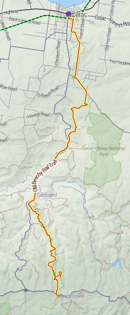
The Old Beechy Rail Trail is a 45–kilometre rail trail in Australia, running from Colac to Beech Forest. The trail includes approximately 30 kilometres of dedicated rail trail, with the rest being on-road. The historic "Beechy" train ran on this line from 1902 to 1962. The trail has 21 seats installed along the route for walkers to rest on, with shelters having been erected at Banool, Wimba, McDevitt and Dinmont. These were the old stopping points where the train would have collected travellers or produce. The original station signs have been replicated and painted in the Victorian railways colours. These being on a black board with white colouring and are positioned at the relevant stopping points along the rail trail. Other facets of the rail trail are the location of information boards as well as replicated road crossing markers. The first section of the Old Beechy Rail Trail was officially opened by Victoria's premier, Mr Steve Bracks in July 2005.

A long-distance trail is a longer recreational trail mainly through rural areas used for hiking, backpacking, cycling, horse riding or cross-country skiing. They exist on all continents except Antarctica.
The Murchison-Rushworth Rail Trail is a multi use bicycle and walking path being constructed along the former train line between Murchison and Rushworth in north central Victoria, Australia. As of November 2013, two kilometres of trail have been constructed at Rushworth, while another ten kilometres at the Murchison end are scheduled for completion by June 2014.

The Grampians Rail Trail is a walking and cycling rail trail in Victoria, Australia.
Bravington railway station was a railway station on the Noojee railway line. It was located in the town of Bravington. It was opened on 12 May 1890 when the railway line was laid through the town and closed in 1958.


