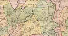
Langtree is a village and parish in north Devon, England, situated about 4 miles (6 km) south-west of Great Torrington and 8 miles (13 km) south of Bideford. Its name means "tall tree". Torridge District Council and Devon County Council are responsible for local government, while for religious administrative purposes it is part of the Archdeaconry of Barnstaple and the Diocese of Exeter. In 2021 the parish had a population of 837.

Peters Marland is a small village and civil parish in the local government district of Torridge, Devon, England. The parish, which lies about four miles south of the town of Great Torrington, is surrounded clockwise from the north by the parishes of Little Torrington, Merton, Petrockstowe, Buckland Filleigh, Shebbear and Langtree. In 2001 its population was 234, down from the 286 residents it had in 1901.

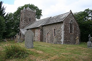
Abbots Bickington is a village and civil parish in the English county of Devon, located 7.7 mi (12.4 km) north-northeast of Holsworthy and near the River Torridge.

North Petherwin is a civil parish and village in the historic county of Devon and the ceremonial county of Cornwall, England, United Kingdom. The village is situated five miles (8 km) northwest of Launceston on a ridge above the River Ottery valley.
Holcombe Rogus is a village, civil parish and ecclesiastical parish in the English county of Devon. In 2001 the population of the parish was 503.

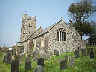
Brendon is a village and former civil parish, now in the parish of Brendon and Countisbury, in the North Devon district, in the county of Devon, England. It is close to the border with Somerset within the Exmoor National Park, the village is 1.5 miles (2.4 km) southeast of Lynton and 15 miles (24 km) west of Minehead in the East Lyn Valley. It is located just off the A39 and is on two long distance footpaths, the Coleridge Way and the Samaritans Way South West. The Church of St Brendon is 2 mi (3 km) from the village and was built in 1738, possibly with building material brought from another site. In 2001 the parish had a population of 159.
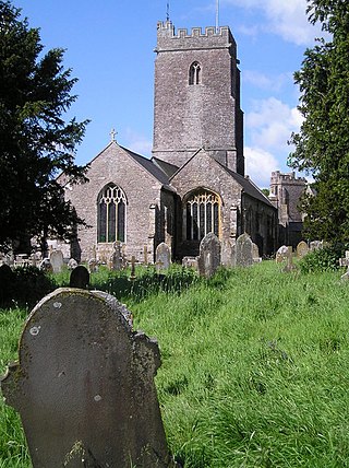
Kingskerswell is a village and civil parish within Teignbridge local government district in the south of Devon, England. The village grew up where an ancient track took the narrowest point across a marshy valley and it is of ancient foundation, being mentioned in the Domesday Book. It has a church dating back to the 14th century and the ruins of a manor house of similar date. The coming of the railway in the 1840s had a large effect on the village, starting its conversion into a commuter town. The village is a major part of the electoral ward called Kerswell-with-Combe. This ward had a population of 5,679 at the 2011 census.

Exeter Racecourse is a thoroughbred horse racing venue located near the city of Exeter, Devon, England. Locally it is known as Haldon racecourse because of its location on top of the Haldon Hills. Until the early 1990s it was officially known as Devon and Exeter.

Rewe is a village and civil parish in the county of Devon in England. It lies on the river Culm, 5 miles (8 km) north of the city of Exeter and 9 miles (14 km) south of the town of Tiverton. Rewe is a linear village, with most of its buildings lying along the A396 road about 1 mile (1.6 km) north of the larger village of Stoke Canon. The Reading to Plymouth railway line also passes through the village, but there has never been a station here; the nearest operating station is Exeter St Davids. Before its closure, Stoke Canon station was the nearest.

Hexworthy is a hamlet on Dartmoor, in Devon, England. It lies on the West Dart River a mile upstream from Dartmeet. Historically in the parish of Lydford, since 1987 it has been in the civil parish of Dartmoor Forest.
The hundred of Haytor was the name of one of thirty two ancient administrative units of Devon, England. The hundred covered the coastal area between the River Teign and River Dart. It was likely named after a lost village located somewhere between Totnes and Newton Abbot.
Lifton Hundred was the name of one of thirty two ancient administrative units of Devon, England.
Kennerleigh is a village and civil parish in Devon, England.

Monkokehampton is a village and civil parish in West Devon, England. The village lies on the River Okement, about 3 miles (4.8 km) east-north-east of Hatherleigh. The parish is bounded by Hatherleigh, Exbourne, Broadwoodkelly and Iddesleigh, and had a population of 139 at the 2011 Census.

Thrushelton or Thruselton is a village and civil parish about 2 and a half miles north of Coryton railway station, in the West Devon district, in the county of Devon, England. In 2011 the parish had a population of 197. The parish touches Bratton Clovelly, Bridestowe, Lewtrenchard, Stowford, Broadwoodwidger, Marystow and Germansweek.

Inwardleigh is a village and civil parish about 3 and a half miles north north west of Okehampton railway station, in the West Devon district, in the county of Devon, England. The parish contains the village of Folly Gate. The A386 road runs through the parish. In 2011 the parish had a population of 491. The parish touches Hatherleigh, Sampford Courtenay, Okehampton Hamlets, Jacobstowe and Northlew.

Sampford Spiney is a village and civil parish in the Walkham valley, about 4 miles east south east of Tavistock, in the West Devon district, in the county of Devon, England. In 2011 the parish had a population of 117. The parish touches Walkhampton, Whitchurch and Horrabridge.

West Anstey is a village and civil parish on the River Yeo, about 5 miles west of Dulverton, in the North Devon district, in the county of Devon, England. In 2011 the parish had a population of 163. The parish touches Molland, East Anstey and Withypool and Hawkridge.

Cheldon is a village and former civil parish, 17 miles (27 km) north-west of Exeter, now in the parish of Chulmleigh, in the North Devon district, in the county of Devon, England. In 1961, the parish had a population of 32.