Hayti Heights, Missouri

Last updated
Hayti Heights, Missouri
Hayti-Heights-84-mo.jpg
Route 84 in Hayti Heights
Pemiscot County Missouri Incorporated and Unincorporated areas Hayti Heights Highlighted.svg
Location of Hayti Heights, Missouri
Coordinates: 36°13′52″N89°46′06″W / 36.23111°N 89.76833°W / 36.23111; -89.76833 Coordinates: 36°13′52″N89°46′06″W / 36.23111°N 89.76833°W / 36.23111; -89.76833 [1]
Country United States
State Missouri
County Pemiscot
Area
[2]
  Total0.98 sq mi (2.54 km2)
  Land0.98 sq mi (2.54 km2)
  Water0.00 sq mi (0.00 km2)
Elevation
[1]
266 ft (81 m)
Population
 (2020)
  Total515
  Density524.97/sq mi (202.77/km2)
Time zone UTC-6 (Central (CST))
  Summer (DST) UTC-5 (CDT)
ZIP code
63851
Area code 573
FIPS code 29-31168 [3]
GNIS feature ID2394337 [1]

Hayti Heights is a city in eastern Pemiscot County in the bootheel of southeast Missouri, United States. The population was 515 at the 2020 census. [4]

Contents

Geography

Hayti Heights lies immediately west of Hayti in eastern Pemiscot County. Missouri Route 84 traverses Hayti Heights from west-to-east. U.S. Route 412 passes through the southern tip of the city. [5]

According to the United States Census Bureau, the city has a total area of 0.98 square miles (2.54 km2), all land. [6]

Demographics

Historical population
CensusPop.Note
1980 1,023
1990 893−12.7%
2000 771−13.7%
2010 626−18.8%
2020 515−17.7%
U.S. Decennial Census [7]

2010 census

As of the census [8] of 2010, there were 626 people, 210 households, and 150 families living in the city. The population density was 638.8 inhabitants per square mile (246.6/km2). There were 244 housing units at an average density of 249.0 per square mile (96.1/km2). The racial makeup of the city was 1.12% White, 98.40% Black or African American, 0.16% Native American, and 0.32% from two or more races. Hispanic or Latino of any race were 0.32% of the population.

There were 210 households, of which 51.0% had children under the age of 18 living with them, 15.2% were married couples living together, 50.5% had a female householder with no husband present, 5.7% had a male householder with no wife present, and 28.6% were non-families. 25.7% of all households were made up of individuals, and 8.6% had someone living alone who was 65 years of age or older. The average household size was 2.98 and the average family size was 3.61.

The median age in the city was 22.8 years. 41.9% of residents were under the age of 18; 10.7% were between the ages of 18 and 24; 20.4% were from 25 to 44; 18.6% were from 45 to 64; and 8.1% were 65 years of age or older. The gender makeup of the city was 45.7% male and 54.3% female.

2000 census

As of the census [3] of 2000, there were 771 people, 254 households, and 183 families living in the city. The population density was 780.0 inhabitants per square mile (301.2/km2). There were 287 housing units at an average density of 290.4 per square mile (112.1/km2). The racial makeup of the city was 0.65% White, 98.31% African American, 0.39% Asian, and 0.65% from two or more races.

There were 254 households, out of which 46.9% had children under the age of 18 living with them, 19.3% were married couples living together, 49.6% had a female householder with no husband present, and 27.6% were non-families. 24.0% of all households were made up of individuals, and 9.1% had someone living alone who was 65 years of age or older. The average household size was 3.04 and the average family size was 3.64.

In the city, the population was spread out, with 44.7% under the age of 18, 9.9% from 18 to 24, 22.7% from 25 to 44, 13.5% from 45 to 64, and 9.2% who were 65 years of age or older. The median age was 21 years. For every 100 females there were 72.9 males. For every 100 females age 18 and over, there were 62.0 males.

The median income for a household in the city was $12,011, and the median income for a family was $15,417. Males had a median income of $23,750 versus $16,786 for females. The per capita income for the city was $6,398. About 55.5% of families and 57.7% of the population were below the poverty line, including 67.1% of those under age 18 and 40.7% of those age 65 or over.

Related Research Articles

<span class="mw-page-title-main">Pemiscot County, Missouri</span> County in Missouri, United States

Pemiscot County is a county located in the southeastern corner in the Bootheel in the U.S. state of Missouri, with the Mississippi River forming its eastern border. As of the 2020 census, the population was 15,661. The largest city and county seat is Caruthersville. The county was officially organized on February 19, 1851. It is named for the local bayou, taken from the word pem-eskaw, meaning "liquid mud", in the language of the native Fox (Meskwaki) people. This has been an area of cotton plantations and later other commodity crops.

<span class="mw-page-title-main">Lamar Heights, Missouri</span> Village in Missouri, United States

Lamar Heights is a village in Barton County, Missouri, United States. The population was 170 at the 2020 census.

<span class="mw-page-title-main">Umber View Heights, Missouri</span> Village in Missouri, United States

Umber View Heights is a village in Cedar County, Missouri, United States. The population was 41 at the 2020 census.

<span class="mw-page-title-main">Glenaire, Missouri</span> City in Missouri, United States

Glenaire is a city in Clay County, Missouri, United States. The population was 539 at the 2020 census. The city is completely surrounded by the city of Liberty. It was originally referred to as "Interurban Heights" or "Belleview" because of the interurban train that ran through the area and stopped at the Belleview depot near the Belleview Dairy. It is part of the Kansas City metropolitan area.

<span class="mw-page-title-main">Brooklyn Heights, Missouri</span> Village in Missouri, United States

Brooklyn Heights is a village in Jasper County, Missouri, United States. The population was 101 at the 2020 census. It is part of the Joplin, Missouri Metropolitan Statistical Area.

<span class="mw-page-title-main">Bragg City, Missouri</span> City in Missouri, United States

Bragg City is a city in Pemiscot County, Missouri, United States. The population was 72 at the 2020 census.

<span class="mw-page-title-main">Caruthersville, Missouri</span> City in Missouri, United States

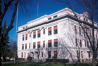
Caruthersville is a city in and the county seat of Pemiscot County, Missouri, United States, located along the Mississippi River in the Bootheel region of the state's far southeast. The population was 5,562, according to the 2020 census.

<span class="mw-page-title-main">Cooter, Missouri</span> City in Missouri, United States

Cooter is a city in Pemiscot County, Missouri, United States. The population was 343 at the 2020 census.

<span class="mw-page-title-main">Hayti, Missouri</span> City in Missouri, United States

Hayti is a city in eastern Pemiscot County, Missouri, United States. The population was 2,493 at the 2020 census.

<span class="mw-page-title-main">Hayward, Missouri</span> Census-designated place in Missouri, United States

Hayward is a census-designated place and former village in Pemiscot County, Missouri, United States. The population was 131 at the 2010 census.

<span class="mw-page-title-main">Holland, Missouri</span> Town in Missouri, United States

Holland is a town in Pemiscot County, Missouri, United States. The population was 194 at the 2020 census.

<span class="mw-page-title-main">Homestown, Missouri</span> City in Missouri, United States

Homestown is a city in Pemiscot County, Missouri, United States. The population was 73 at the 2020 census.

<span class="mw-page-title-main">North Wardell, Missouri</span> Former Village in Missouri, United States

North Wardell was a village in Pemiscot County, Missouri, United States. The population was 170 at the 2000 census.

<span class="mw-page-title-main">Pascola, Missouri</span> Village in Missouri, United States

Pascola is a village in Pemiscot County, Missouri, United States. The population was 108 at the 2010 census.

<span class="mw-page-title-main">Steele, Missouri</span> City in Missouri, United States

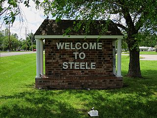
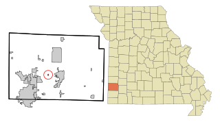
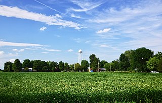
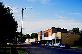
Steele is a city in southern Pemiscot County in the Missouri Bootheel of southeastern Missouri, United States. The population was 1,853 at the 2020 census.

<span class="mw-page-title-main">Wardell, Missouri</span> City in Missouri, United States

Wardell is a city in Pemiscot County, Missouri, United States. The population was 310 at the 2020 census. It annexed North Wardell in 2007.

<span class="mw-page-title-main">Parkville, Missouri</span> City in Missouri, United States

Parkville is a city in Platte County, Missouri, United States and is a part of the Kansas City Metropolitan Area. The population was 7,177 at the 2020 census. Parkville is known for its antique shops, art galleries, and historic downtown. The city is home to Park University, English Landing Park, Platte Landing Park, and the National Golf Club of Kansas City. Large neighborhoods in Parkville include: Riss Lake, The National, Thousand Oaks, Creekside, Parkville Heights, River Hills, Riverchase, The Bluffs, Downtown, and Pinecrest.

<span class="mw-page-title-main">Wood Heights, Missouri</span> City in Missouri, United States

Wood Heights is a city in western Ray County, Missouri, and part of the Kansas City metropolitan area within the United States. The population was 757 at the 2020 census.

<span class="mw-page-title-main">Hayti, South Dakota</span> Town in South Dakota, United States

Hayti is a town in and county seat of Hamlin County, South Dakota, United States. The population was 393 at the 2020 census. It is part of the Watertown, South Dakota Micropolitan Statistical Area. It is the county seat of Hamlin County.

<span class="mw-page-title-main">Portageville, Missouri</span> City in Missouri, United States

Portageville is a city in New Madrid and Pemiscot counties in the U.S. state of Missouri. The population was 2,942 according to the 2020 Census.

References

  1. 1 2 3 U.S. Geological Survey Geographic Names Information System: Hayti Heights, Missouri
  2. "ArcGIS REST Services Directory". United States Census Bureau. Retrieved August 28, 2022.
  3. 1 2 "U.S. Census website". United States Census Bureau . Retrieved 2008-01-31.
  4. "Explore Census Data". data.census.gov. Retrieved 2021-12-12.
  5. Missouri Atlas & Gazetteer, DeLorme, 1998, First edition, p. 71, ISBN   0-89933-224-2
  6. "US Gazetteer files 2010". United States Census Bureau . Retrieved 2012-07-08.
  7. "Census of Population and Housing". Census.gov. Retrieved June 4, 2015.
  8. "U.S. Census website". United States Census Bureau . Retrieved 2012-07-08.